Tags
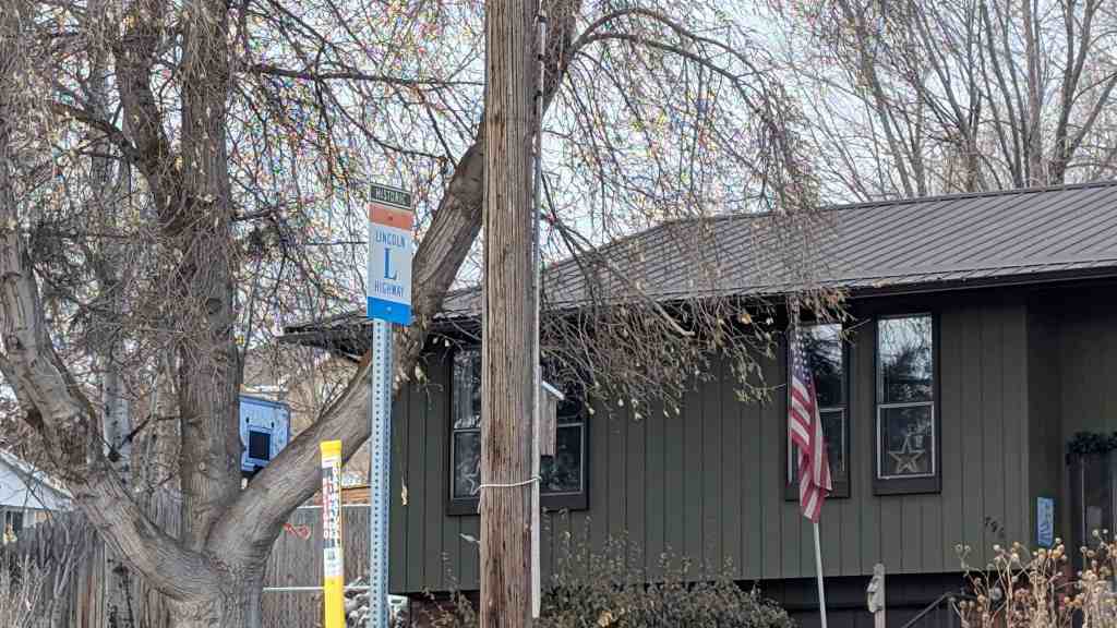
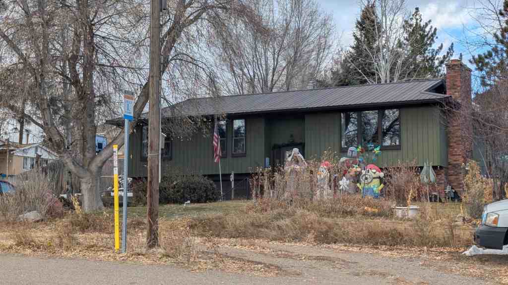
796 North 700 East in Morgan, Utah
A Lincoln Highway Marker in Morgan, Utah across the street from the North Morgan Cemetery.

28 Saturday Feb 2026
Posted in Uncategorized
Tags
796 North 700 East in Morgan, Utah
A Lincoln Highway Marker in Morgan, Utah across the street from the North Morgan Cemetery.
18 Thursday Sep 2025
Posted in Uncategorized
Tags
Lincoln Highway Bridge
During the early days of Tooele County area around 1900 a road was constructed over Johnson Pass and on west across what is now Dugway Proving Ground. The Goodyear Tire and Rubber Co. was interested in opening a road to the west which became the Lincoln Highway. Mr. Fisher was president of the company and invested a large amount of money in the project. A group of convicts from Utah State Prison were camped at Clover Creek in order to start the construction, and later moved west as the road progressed. Their work included the construction of subject bridge and tiie building up of the elevated causeway from Granite Peak to the west edge of the salt flats. The portion of the road from Johnson Pass to west edge of the salt flats was known as the Goodyear Cut-off in honor of the interest and money the company invested. Attempts to make this road the main route to the west coast were not successful as certain influential persons in Salt Lake City wanted the western route to pass through that city. Therefore the Lincoln Highway passing through Dugway Proving Ground was abandoned in the early 1920’s, and was used by local ranchers and mining interests. This bridge is an existing structure of the original national Lincoln Highway from Lincoln, Nebraska to Sacramento, California. It is the only significant structure in this area that remains of the original proposed national highway.
The Lincoln Highway Bridge was added to the National Register of Historic Places (#75001825) on May 21, 1975 and is located in the Ditto area of Dugway, Utah.
Related:
The bridge is of hewn logs and log supports. Hewn logs make up deck of bridge and circular logs make up supporting members. Abutments are of rock construction with concrete added in early 1930’s by CCC Camp to support badly deteriorated rock abutments. Dimensions are.14V-6″ long by ll’-6″ wide. Rails along the sides of the bridge have fallen “off. It is estimated that the structure was built about 1900, with rehabilitation by CCC Camp at Clover Creek in the early 1930’s. A new road and bridge diverted traffic away from bridge; consequently, it has remained in fairly good condition.
20 Tuesday Aug 2024
Posted in Uncategorized
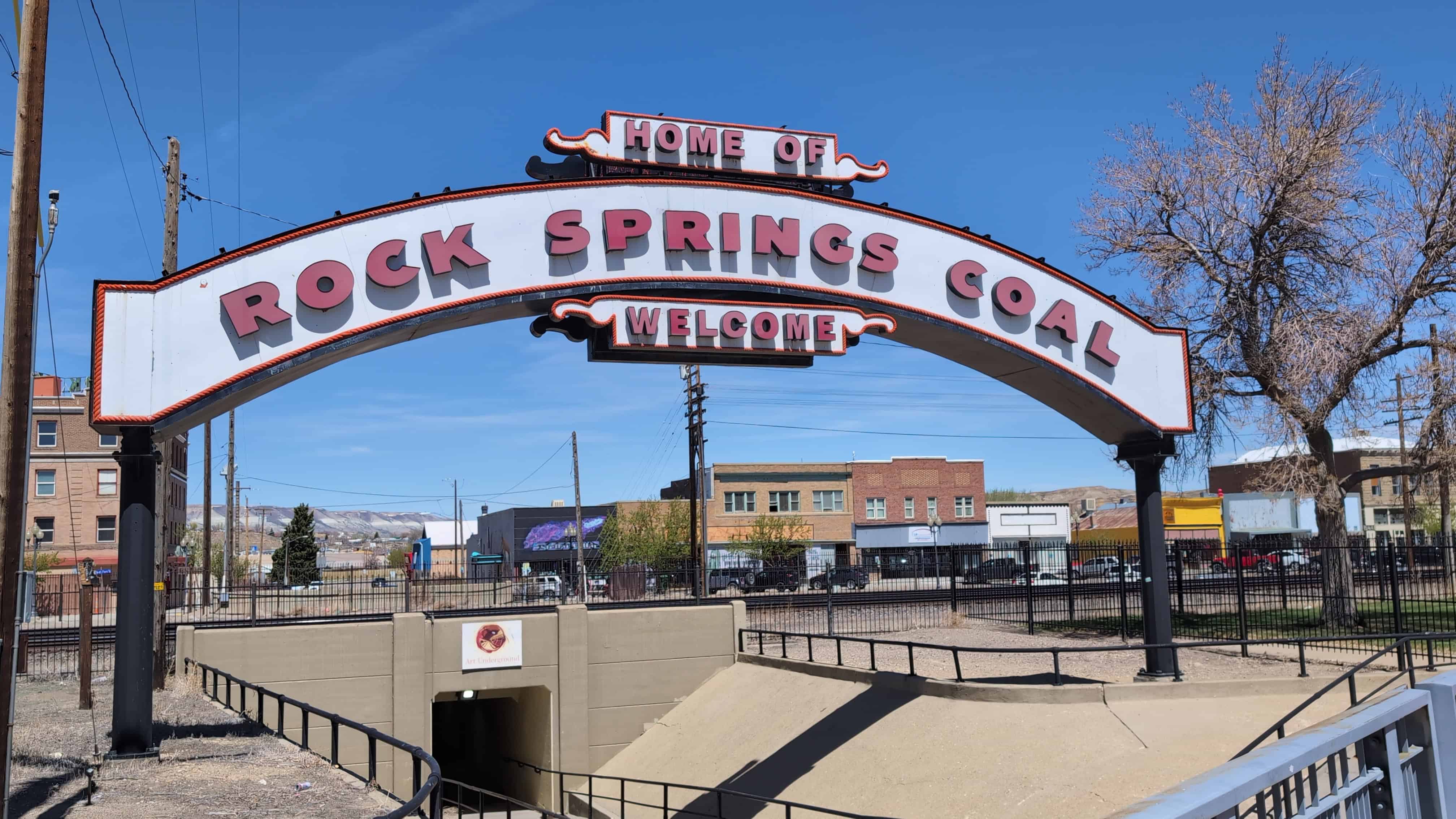
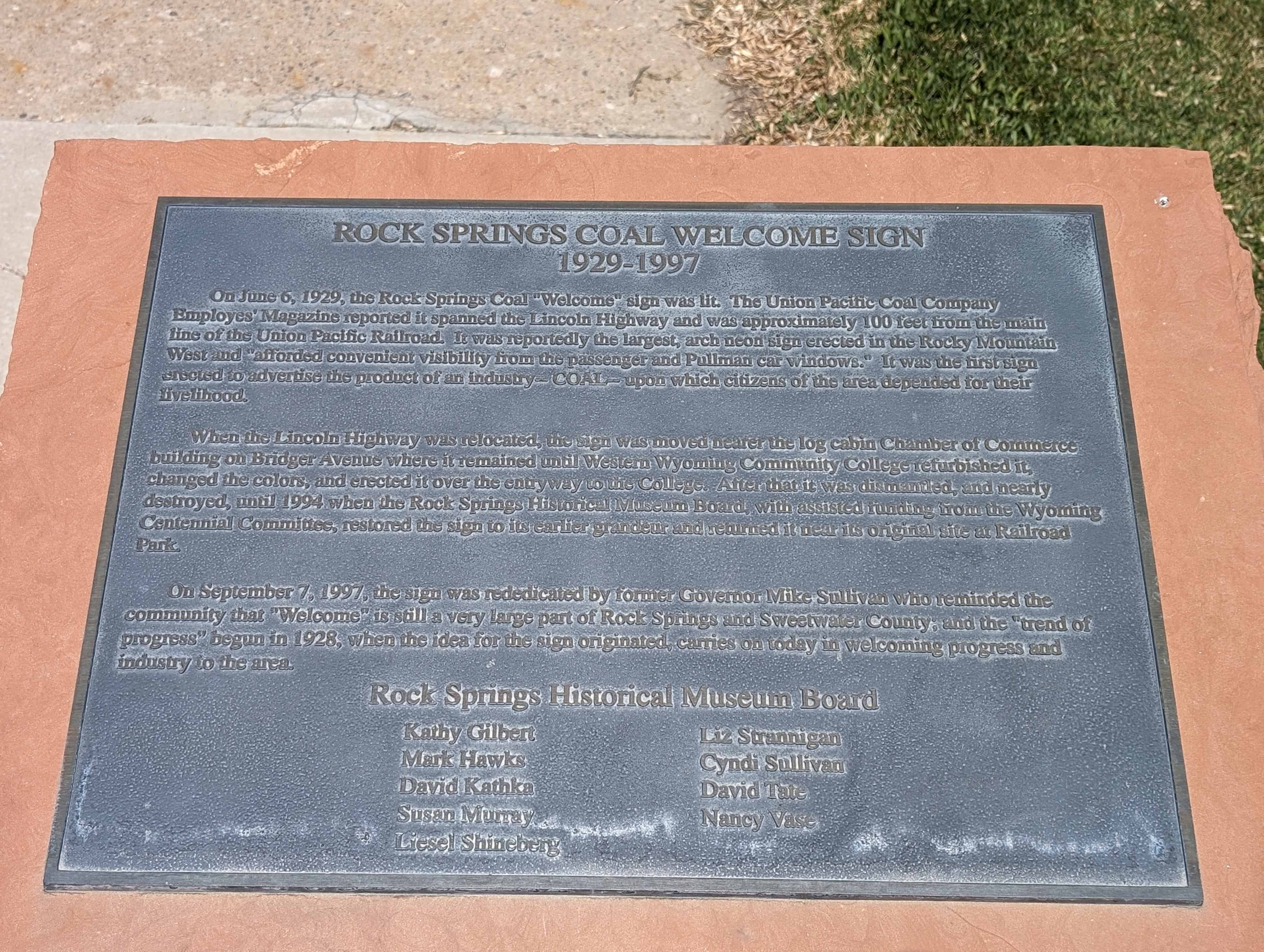
Rock Springs Coal Welcome Sign
1929-1997
On June 6, 1929, the Rock Springs Coal “Welcome” sign was lit. The Union Pacific Coal Company Employees’ Magazine reported it spanned the Lincoln Highway and was approximately 100 feet from the main line of the Union Pacific Railroad. It was reportedly the largest, arch neon sign erected in the Rocky Mountain West and “afforded convenient visibility from the passenger and Pullman car windows.” It was the first sign erected to advertise the product of an industry – COAL – upon which citizens of the area depended for their livelihood.
When the Lincoln Highway was relocated, the sign was moved nearer the log cabin Chamber of Commerce building on Bridger Avenue where it remained until Western Wyoming Community College refurbished it, changed the colors, and erected it over the entryway to the College. After that it was dismantled, and nearly destroyed, until 1994 when the Rock Springs Historical Museum Board, with assisted funding from the Wyoming Centennial Committee, restored the sign to its earlier grandeur and returned it near its original site at Railroad Park.
On September 7, 1997, the sign was rededicated by former Governor Mike Sullivan who reminded the community that “Welcome” is still a very large part of Rock Springs and Sweetwater County; and the “trend of progress” begun in 1928, when the idea for the sign originated, carries on today in welcoming progress and industry to the area.

The sign is located at Main Street and C Street in Rock Springs, Wyoming.
17 Friday Nov 2023
Posted in Uncategorized
11 Saturday Nov 2023
Posted in Uncategorized
Tags

Fisher Pass – Elevation 6,496 Feet
The idea of the Lincoln Highway came from the creative mind of Carl Fisher, the man also responsible for the Indianapolis Motor Speedway and Miami Beach. With help from fellow industrialists Frank Seiberling and Henry Joy, an improved, hard-surfaced road was envisioned that would stretch almost 3,400 miles from coast to coast, New York to San Francisco, over the shortest practical route. The Lincoln Highway Association was created in 1913 to promote the road, using private and corporate donations. The Lincoln Highway was completed in 1930 and passed here through Fisher Pass along current State Route 199. This was the first Transcontinental Highway.
“Not only was the Lincoln Highway to be the greatest memorial, but a perpetual memorial. The Lincoln Highway will never be finished.“
The Lincoln Highway-America’s First Highway
The old Lincoln Highway follows today’s State Route 199 over the Stansbury Mountains into Skull Valley. This road was completed in 1919, at which time this pass was officially named Fisher Pass. The pass was named after Carl G. Fisher who had contributed $25,000 to pay for the construction of the road over this difficult section of the Lincoln Highway.
The Rocks used in this monument are from the rocks blasted and moved from Devils Gate, about 1 mile west of here, to complete the construction of this road.
Related:
Located at N 40.33735 W 112.57291


17 Monday Jul 2023
Posted in Uncategorized
Tags
15 Thursday Dec 2022
Posted in Uncategorized

The Lincoln Highway
America’s First Coast-to-Coast Automobile Highway
The Lincoln Highway was established in 1913 when a group of businessmen involved in the automobile industry decided to sponsor and promote a transcontinental highway for automobile traffic.
They organized the Lincoln Highway Association and dedicated their proposed highway to the memory of President Abraham Lincoln. On September 10, 1913, the route of the highway was announced, and the general public was invited to become members of the association. Contributions to help finance the improvement of the highway were solicited from businesses and private citizens.
The route that was chosen for the Lincoln Highway went from New York City to San Francisco, following the straightest line that was possible. In the beginning, the route was laid out along already existing roads, but an important part of the plan was that these roads would be improved and the route shortened wherever possible.
A major goal of the Lincoln Highway Association was to persuade local, state, and the federal government to get involved in the improvement and construction of automobile roads and highways. The Association wanted the Lincoln Highway to be a model for the building of roads throughout the United States. By 1928 they felt that for the most part they had achieved their goals, and it was decided to dissolve the association. But the Lincoln Highway lives on. Although most of the original highway has been replaced by modern roads such as US Highway 30, US 40, and Interstate 80, many sections of the Lincoln Highway are still being used today.
In western Utah, the original 1913 route of the Lincoln Highway came through the city of Grantsville, then continued west through Skull Valley, Fish Springs, Callao, and Ibapah. In 1919, construction projects at Johnson Pass in the Stansbury Mountains and on the mud flats west of Granite Peak were completed, and the route was changed to go through Tooele and Gold Hill, which shortened the route by about 50 miles. Grantsville was dropped from the route. But another change came in 1927. For several years, the state of Utah had been working on a road across the Great Salt Lake Desert to Wendover, a small town on the Nevada border. This project was completed in 1925, and two years later, the Lincoln Highway Association made the decision to incorporate this new road into its official route. Grantsville was on the Lincoln Highway again.

This is Sons of Utah Pioneers historic marker #178, located at Lincoln Park, 550 West Clark Street in Grantsville, Utah


18 Thursday Aug 2022
Posted in Uncategorized
Tags

The Lincoln Highway: A Vision that Spanned America
The Visionary: Carl Fisher was a dreamer with an entrepreneurial spirit. After amassing a large fortune and building a reputation in the auto-parts industry, Fisher began to dream of building a paved, hard-surface, coast-to-coast highway. He envisioned a magnificent roadway that spanned the United States and officially closed the gap between the East and the West forever.
The Vision: Prior to the Lincoln Highway’s completion, the majority of roadways in America were unpaved, dusty trails that aimlessly crooked and kinked from one settlement to the next. The disjointed nature of the roadways did not permit transcontinental travel. Fisher recognized the growing popularity of the automobile and saw the need for a national road which would allow individuals to travel at their own pace, a luxury not afforded by trains.
Construction began in 1913 with the proposed highway route starting in Times Square in New York City and passing through New Jersey, Pennsylvania, Ohio, Indiana, Illinois, Iowa, Nebraska, Wyoming, Utah, Nevada, and ending in San Francisco, California’s Lincoln Park. As the construction effort moved forward, paving the roadway became an expensive proposition, and much of the route was left unpaved until state and federal funds were invested in the project almost a decade later.
The Vision Fades: The Lincoln Highway triggered the American people’s desire to connect and drive across the nation. Witnessing the economic prosperity that followed the highway route, every state in the Union wanted a named highway built within their borders. Soon, named highways began to pepper the landscape. The new roadways shared routes, intersecting and overlapping in a confusing tangle. The time for a national system of highways was looming.
In March 1925, the American Association of State Highway Officials ( AASHO ) started planning a federal highway system. All named roads (including the Lincoln Highway) were ignored in their planning. Eventually, the Lincoln Highway was broken up into U.S. 1, U.S. 30 (including U.S. 30N and U.S. 30S ), U.S. 530, U.S. 40, and U.S. 50. All road signs featuring the Lincoln Highway name were removed. By the 1940s, the Lincoln Highway had faded away.

This historic marker is located at the Schellbourne Rest Area is located along Highway 93 in Nevada.
20 Wednesday Jul 2022
Posted in Uncategorized
Tags
Ely, Historic Markers, Lincoln Highway, Nevada, Nevada Historic Markers, Railroad, White Pine County

Nevada Northern Railway
Mark Requa’s Nevada Consolidated Copper Company laid 150-mile of track from Cobre, on the Southern Pacific line, to Ely in 1905-06 to haul ore from the Copper Flat mines west of Ely.
Ore was loaded into railroad gondolas at Copper Flat for the trip to the smelter at McGill, over a double-track trestle that was 1720 feet long. The trestle burned in 1922 and was replaced with an earth-fill span.
Passenger service and the “school train” carrying McGill youth to Ely High School ended in 1941. With the closing of local copper mines in 1983, the railroad ceased operations. Currently, part of the line serves the Nevada Northern Railway Museum for live steam rides. The East Ely shop complex for the Railway was listed as a National Historic Landmark District in 2006.
This is Nevada State Historical Marker #100 located at the White Pine Public Museum at 2000 East Aultman Street in Ely, Nevada.
See others on this page:
Related:


16 Saturday Jul 2022
Posted in Uncategorized

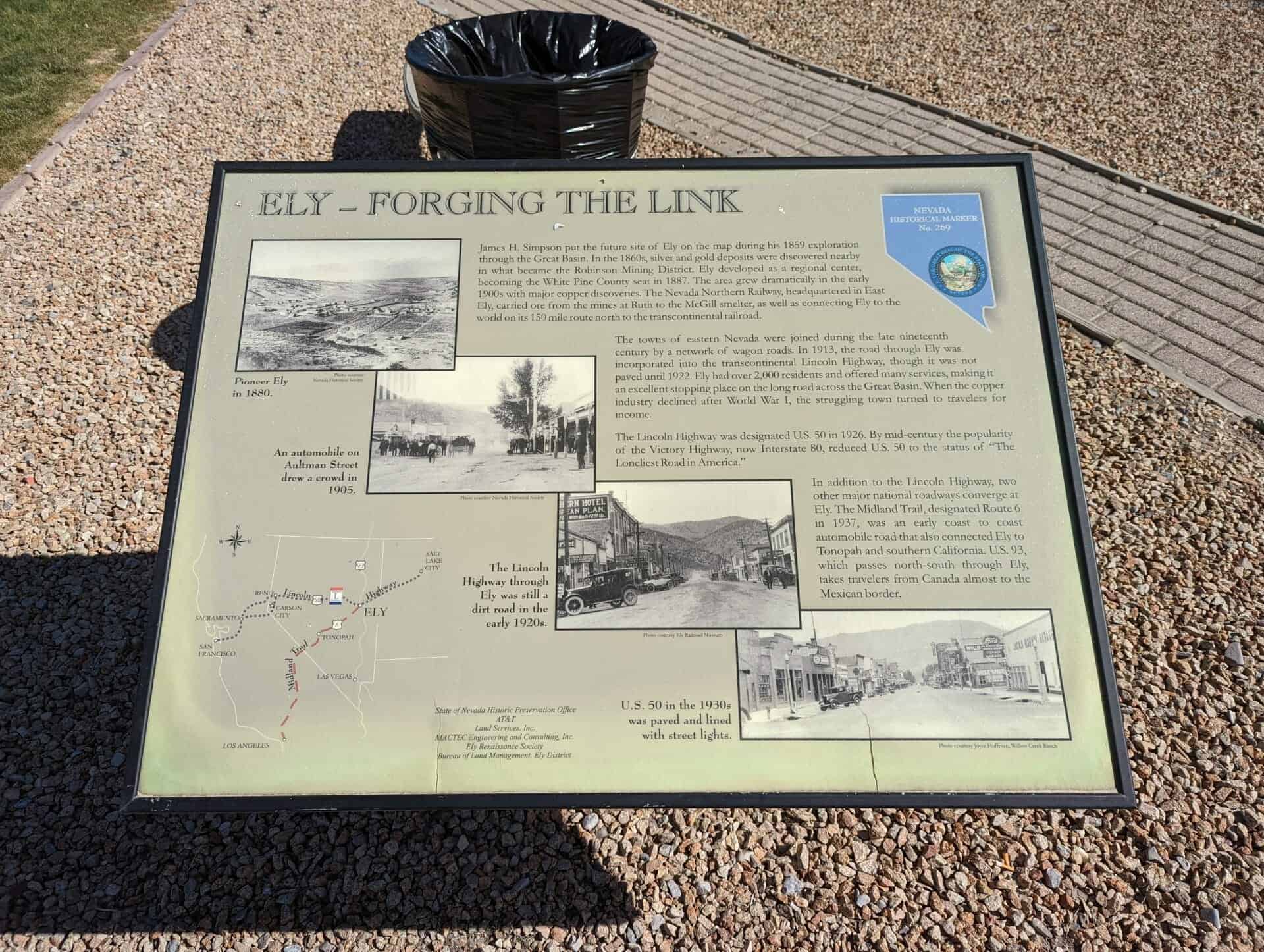
Ely – Forging the Link
James H. Simpson put the future site of Ely on the map during his 1859 exploration through the Great Basin. In the 1860s, silver and gold deposits were discovered nearby in what became the Robinson Mining District. Ely developed as a regional center, becoming the White Pine County seat in 1887. The area grew dramatically in the early 1890s with major copper discoveries. The Nevada Northern Railway, headquartered in East Ely, carried ore from the mines in Ruth to the McGill smelter, as well as connecting Ely to the world on its 150 mile route north to the transcontinental railroad.
The towns of eastern Nevada were joined during the late nineteenth century by a network of wagon roads. In 1913, the road through Ely was incorporated into the transcontinental Lincoln Highway, though it was not paved until 1922. Ely had over 2,000 residents and offered many services, making it an excellent stopping place on the long road across the Great Basin. When the copper industry declined after World War I, the struggling town turned to travelers for income.
The Lincoln Highway was designated U.S. 50 in 1926. By mid-century the popularity of the Victory Highway, now Interstate 80, reduced U.S. 50 to the status of “The Loneliest Road in America.”
In addition to the Lincoln Highway, two other major national roadways converge at Ely. The Midland trail, designated Route 6 in 1937, was an early coast to coast automobile road that also connected Ely to Tonopah and southern California. U.S 93, which passes north-south through Ely takes travelers from Canada almost to the Mexican border.
This is Nevada State Historical Marker #269, located at 681 East Aultman Street in Ely, Nevada.
See others on this page:
Related: