Tags
Cemeteries, Granite, historic, Salt Lake County, Sandy, utah

23 Monday Mar 2015
Posted in Uncategorized
Tags
Cemeteries, Granite, historic, Salt Lake County, Sandy, utah
23 Tuesday Dec 2014
Posted in Uncategorized
Tags
Big Cottonwood Canyon, Cottonwood Heights, Geology, Holladay, Little Cottonwood Canyon, Murray, Salt Lake City, Salt Lake County, Sandy
See Also: G.K. Gilbert Geologic View Park
Little Cottonwood Rocks
Geology and History of Little Cottonwood Canyon.
Little Cottonwood Bedrock
Three Bedrock units are visible on the north side of, and in Little Cottonwood Canyon :

Little Willow Formation
The little willow formation is approximately 1.7 billion years old, making it the oldest rock in the Salt Lake City area. The highly metamorphosed rock consists primarily of intensely contorted quartz schist and gneiss intruded by igneous rocks that have been altered to amphibolite and chlorite schist.
Big Cottonwood Formation
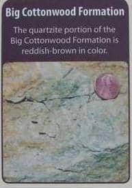
Big Cottonwood Formation
One billion to 850 million years old, the Big Cottonwood Formation is a low-grade metamorphic rock that consists of reddish-brown quartzite and black to purple to green shale, argilite, and slate. Originally deposited along the shoreline of an ancient sea, ripple marks and mud cracks are still preserved in this rock.
The rock on the north canyon wall is easy to distinguish from the adjacent light gray “granite” father up the canyon.
Little Cottonwood Stock

Little Cottonwood Stock
This igneous rock is quartz monzonite, or more generally called granite. Between 32 and 31 million years ago, magma pushed up through the crust into overlying rock layers and then cooled and solidified before reaching the surface. Quartz monzonite is composed of plagioclase, quartz, orthoclase, biotite, and hornblende.
Popular for rock climbing, this light grey granite rock makes up most of the canyon walls.
A history of the rocks in this area :


23 Tuesday Dec 2014
Posted in Uncategorized
Tags
Cottonwood Heights, Fort Union, Holladay, Midvale, Murray, Salt Lake City, Salt Lake County, Sandy, utah
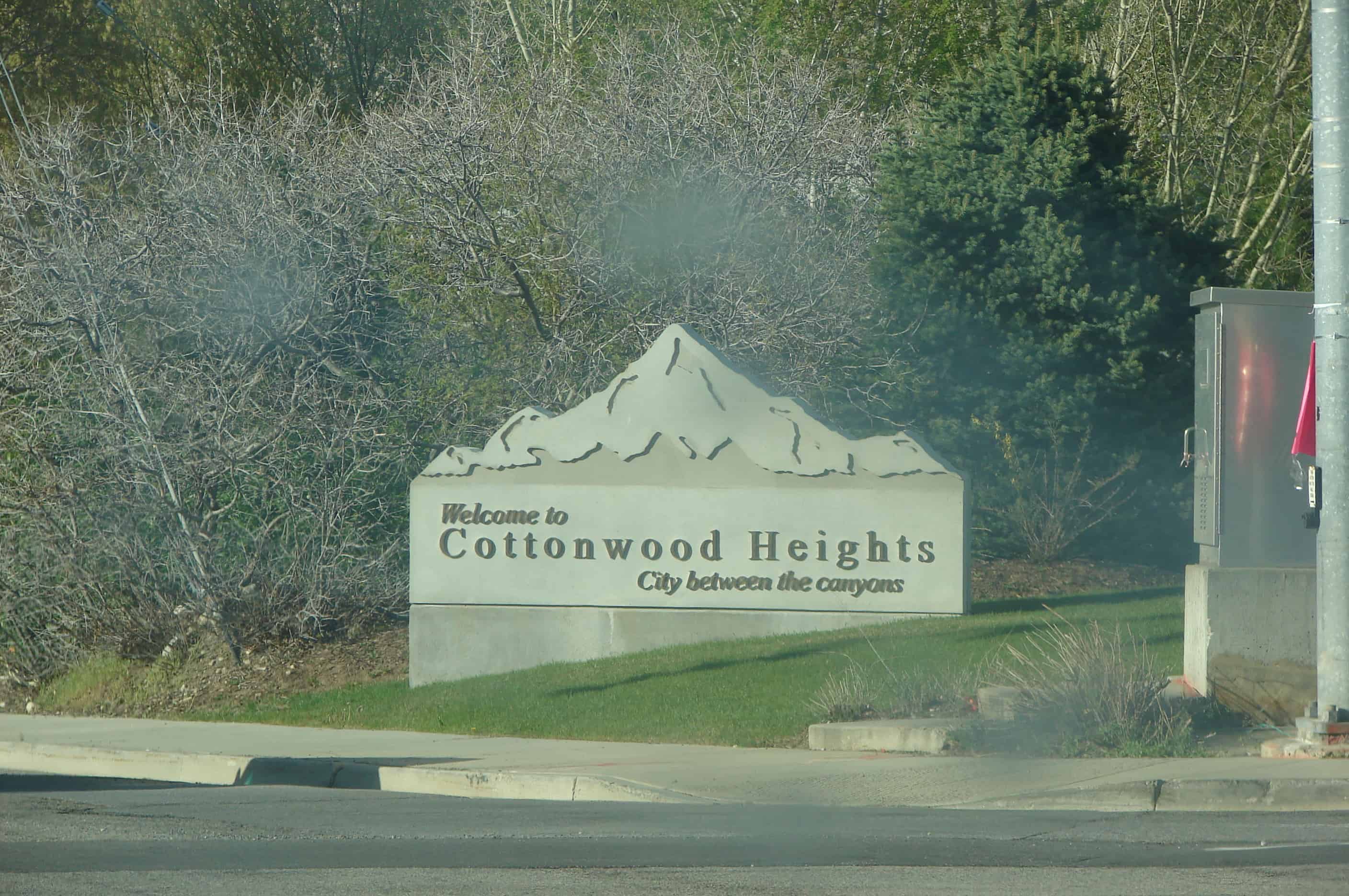
Cottonwood Heights Posts:
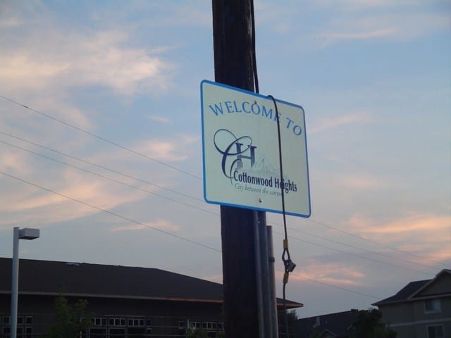
The first use of the Cottonwood Heights name occurred in 1937 when J.D. Fife, Sr., a Butlerville resident, so named his proposed subdivision. The name was officially adopted in 1953 by the newly organized Cottonwood Heights Community Council.
21 Thursday Aug 2014
Posted in Uncategorized
Tags
Big Cottonwood Canyon, DUP, historic, Mining, Salt Lake City, Salt Lake County, Sandy, Silver Fork, utah

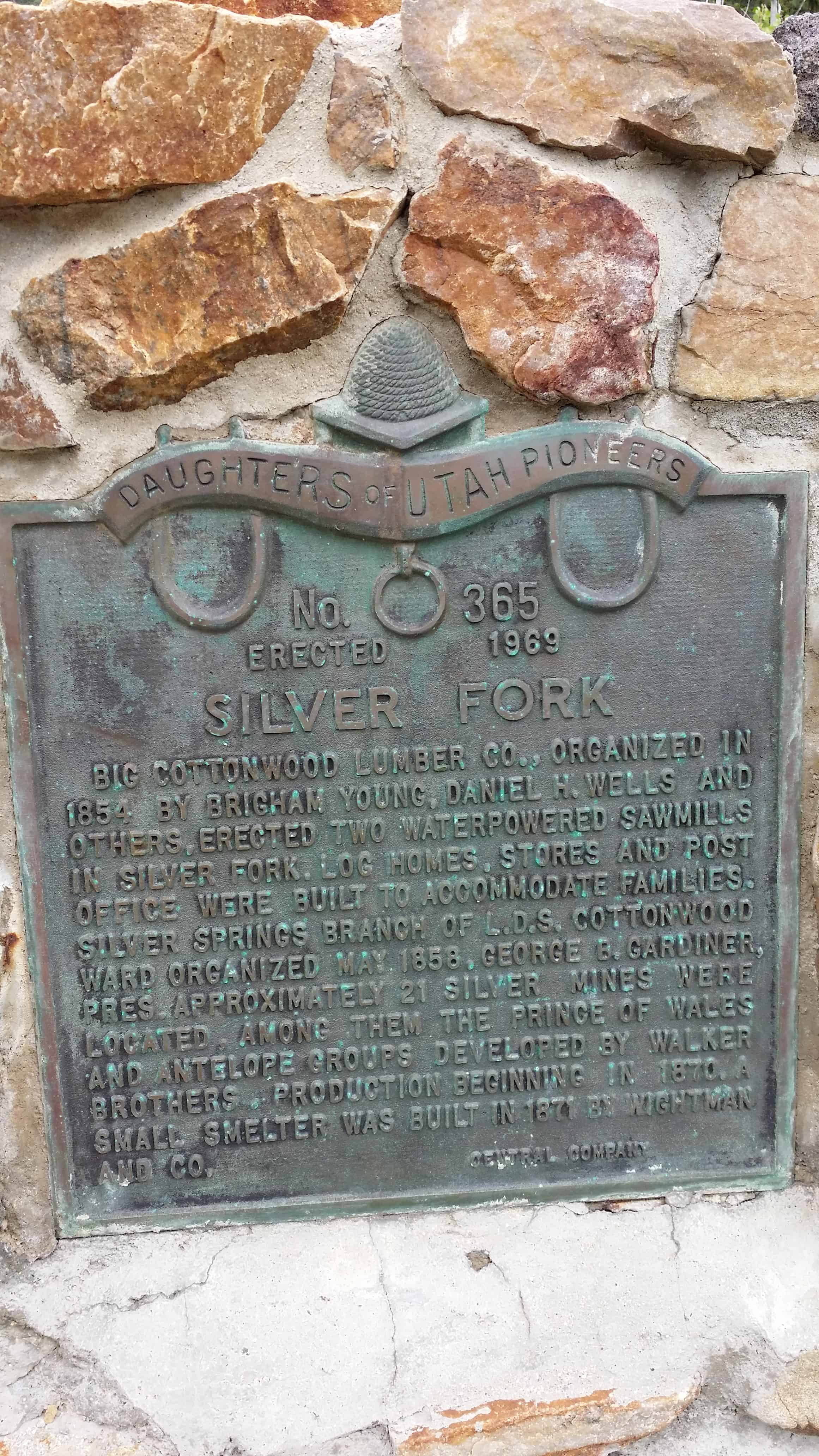
Big Cottonwood Lumber Co., organized in 1854 by Brigham Young, Daniel H. Wells and Others, erected two waterpowered sawmills In Silver Fork. Log homes, stores and post Office were built to accommodate families. Silver springs branch of the L.D.S. Cottonwood Ward organized may 1858, George b. Gardiner, Pres. Approximately 21 silver mines were Located. Among them, the prince of wales and antelope groups developed by Walker Brothers. Production beginning in 1870.
A small smelter was built in 1871 by Wightman And Co.
This D.U.P. Marker is located in Big Cottonwood Canyon.


Silver Fork is one of the last forks branching to the south in Big Cottonwood Canyon before reaching Brighton and Silver Lake. Silver Fork, the canyon, is today best known for the large concentration of summer homes and family cabins at its mouth that is Silver Fork, the town.
From the present day tree covered appearance you would hardly guess that this area began as a base for early logging operations. It would be more than 20 years before mining would play a part in the area’s history.
Logging began shortly after the arrival of the pioneers in 1847, by 1854 the Big Cottonwood Lumber Company was in operation with two saw mills and a shingle mill. The mills were located on the flats at the mouth of Silver Fork. A small community of log buildings quickly sprang up around the operation, all there to support the mills and lumbermen who worked them. In time the sawmills relocated and the town was partially abandoned.
By 1870, the one time logging camp became a mining camp. It didn’t take long for the flurry of activity in Little Cottonwood Canyon at Alta to spill over the ridge and into the tops of Silver and Honeycomb Forks. With that activity, and the rush that accompanied it, the town came to life, supporting the mines just as it had the loggers previously. A small smelter was constructed, another hotel, commercial buildings, and the once abandoned cabins, became homes again.
This second life of the town would be short lived, as the mining boom ended by the mid 1880’s. Some mining did take place after this time, but larger mills and smelters in the valley and improved transportation methods combined to set Silver Fork up for its second abandonment.
In 1893, the area was homesteaded by Joy Dunyon who ran sheep in the fork for many years. Around 1925, the Dunyon family who still owned the property, subdivided the land, and the present community of Silver Fork with its many summer homes and mountain cabins came to be.(1) The third life of the town has never ended, and the fork has been a hiking destination in the summer, and a back country skiing area in the winter. It is the skiing that may most directly affect the town and the futuer of Silver Fork.
A fourth life to the area may be in the works. Just this year (2010) Solitude Ski Resort made application to expand their ski resort operations into Silver Fork. At least a part of it. The original application that would have opened the entire fork, some 463 acres, was withdrawn or denied, depending on who you talk to. A second, smaller impact application was then submitted. This application would open 182 acres, pretty much the entire east face of the fork from the ridge with Honeycomb Fork down the slope to within 100 feet of SIlver Creek along its entire length.
If this access were granted, it would encompass almost all of the historic mining sites in Silver Fork, including the Prince of Wales, Wellington, and others. What remains may have to be “reclaimed” to make it safe for the rest of us. If the state does this work, it usually means destroying it. I hope that preservation would be mandated as a part of any permit, but that is a battle yet to be fought.
While that third life goes on, the fourth life being argued, the second life is the focus of this work; the mining boom. One of the earliest mines in the entire territory to have a steam compressor, the Wellington, is found in Silver Fork as well as the Prince of Wales, Antelope, Highland Chief, Boston Tunnel, Alta Tunnel, Star Tunnel, Warrior, Lucky Dutchman and more.
Silver Fork is also the access-way for a large branch fork to the east and south, Honeycomb Fork.
Silver Fork has no structures that remain standing from those early days, but there is hardware, some of it partially buried, but visible nonetheless. That which can be seen, shows the beauty and craftsmanship of those metal workers who designed and built the machinery of mining.(*)

11 Monday Aug 2014
Posted in Uncategorized
Just north of 7200 South street, on the west side of State Street, stood Travelers’ Rest, or Traders’ Rest, the first pony express station out of Salt Lake City. This station was probably used only for a short time, and no evidence of its existence can be found at the site. The location is marked by a granite marker placed by the Pony Express Trail Association.
Richard F. Fike and John W. Headley locate this first station site west of Salt Lake City nine miles south of the Salt Lake House. The station once stood on State Street in an area referred to as Lovendahl’s Corner. Some sources generally identify this first relay station as Trader’s Rest or Traveler’s Rest. The 1861 mail contract identified Trader’s Rest Station, where Absalom Smith managed station operations. After the Pony Express era, someone added wood siding and a false front to the adobe building to convert it into a business establishment. The building was also used as a garage prior to its destruction sometime before 1979.


05 Tuesday Aug 2014
Posted in Uncategorized
Tags

Only a few yards from this monument – to the Northwest – stood the Milo Andrus “Halfway House”, a comfortable and convenient two-story pioneer inn. The inn was one of several built along State Street in the 1850-80 period to care for the many south and northbound travelers. The Andrus Inn became known as the “Halfway House” because it was located midway between “Traveler’s Rest” at 6400 South State and Porter Rockwell‘s layout near the Point of the Mountain. If one were walking, riding horseback or in a buggy or ther (sic) horse-drawn conveyance, the Andrus place was always a welcome stop. Built in 1859 and the early part of the 1860’s, the Halfway House served as both a hotel and a family residence for 120 years. The structure was moved from here beginning in 1982 to the Pioneer Trails State Park in Salt Lake City after its history was authenticated by the State. The inn was actually a project of Lucy Loomis Tuttle Andrus, one of several wives of Milo. Lucy was a widow with children when Milo married her in 1850 as they were crossing the plains. At the time he was leader of some Church members who were enroute to Utah from England. After the group arrived in Utah, he worked hard to get them all situated. During the 1850’s Milo and his families were involved in the great Church colonization program. Locations they helped settle were Green River, Dixie and Cache Valley in Utah, and Oxford and the Salmon River Country in Idaho. They eventually bought 160 acres in the Dry Creek area of the Jordon Bottoms that included this land on State Street. This area is now part of the community of Crescent.
See other historic markers in the series on this page for SUP Markers.

05 Tuesday Aug 2014
Posted in Uncategorized
Tags
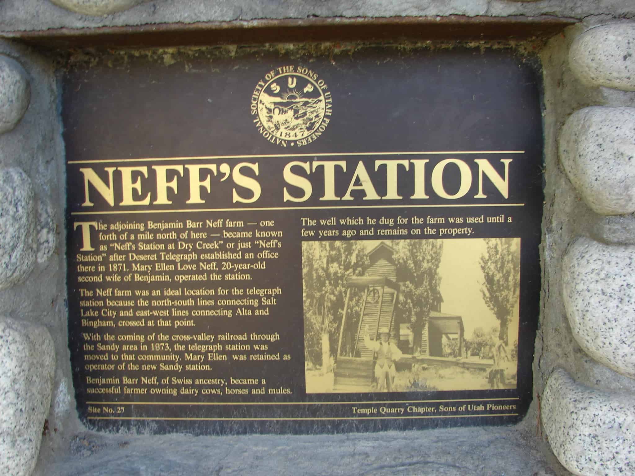
The adjoining Benjamin Barr Neff farm – one forth (sic) of a mile north of here – became known as “Neff’s Station at Dry Creek” or just “Neff’s Station” after Deseret Telegraph established an office here in 1871. Mary Ellen Love Neff, 20-year-old second wife of Benjamin operated the station. The Neff farm was an ideal location for the telegraph station because the north-south line connecting Salt Lake City and east-west lines connecting Alta and Bingham, crossed at that point. With the coming of the cross-valley railroad through the Sandy area in 1873, the telegraph station was moved to that community. Mary Ellen was retained as operator for the new Sandy station. Benjamin Barr Neff, of Swiss ancestry, became a successful farmer owning dairy cows, horses and mules. The well which he dug for the farm was used until a few years ago and remains on the property.
See other historic markers in the series on this page for SUP Markers.
09 Monday Jun 2014
Posted in Uncategorized
Tags
DUP, historic, Historic Markers, Salt Lake County, Sandy, Smelters, utah

The Mingo Smelter was the largest single producer in Utah of metals such as gold, silver, and lead. When it began in 1873, it was known as the Mountain Chief Smelter and was renamed the Mingo smelter in 1876 when it was expanded. By 1881 it produced 19,000,000 pounds of unrefined metal which was shipped to Pennsylvania. The rich ores came from Little Cottonwood Canyon, Bingham Canyon and Lark and provided work for 500 to 1,200 men. Power for the smelter was provided by water traveling through a network of canals to Allsop’s Pond on the south side of Locust Street. From there, it was channeled through wooden pipes to Mingo. In 1877 the plant consisted of Blake crusher, one pair of Cornish rolls, two reverberatory furnaces for ore, matte, and flue dust, three blast furnaces, two boilers, three blowers, and one 35 horsepower horizontal engine. The iron flux came from the Tintic District, the limestone was bought in Salt Lake City, and the fuel used was coke.
Using all four of its furnaces, the Mingo Smelter could produce enough metal to fill sixteen railroad cars each week. It was destroyed by fire in 1887 and was rebuilt in 1888. The Mingo closed in April 1901 when the ores were depleted. This was one of the most successful of the old smelters that operated in Utah.
The above text is from the monument erected in 1993, located at 50 East 9000 South in Sandy, Utah


06 Friday Jun 2014
Posted in Uncategorized
Tags
In 1871, Utah Southern Railroad from Salt Lake was finished and station built here. Wasatch and Jordan Valley Line ran east to granite quarry to bring to this junction huge rocks for constructing S. L. Temple. Later, a narrow-gauge, completely covered with a snowshed, was extended to Alta silver mines. Empty cars were drawn up the steep grade by horse team. Two ore-filled cars were coasted down backwards. The brakes were operated by one man from the rear car. Between Wasatch and Alta the grade was too steep for even the most powerful locomotives, being at one place nearly six hundred feet to the mile; consequently, the empty cars had to be drawn up by horses. The traffic consisted almost entirely of ores from the Alta mines bound for sampling works at Sandy.
The above text is from the monument erected in 1977, located in Bicentennial Park at 530 East 8680 South in Sandy, Utah.

29 Thursday May 2014
Posted in Uncategorized

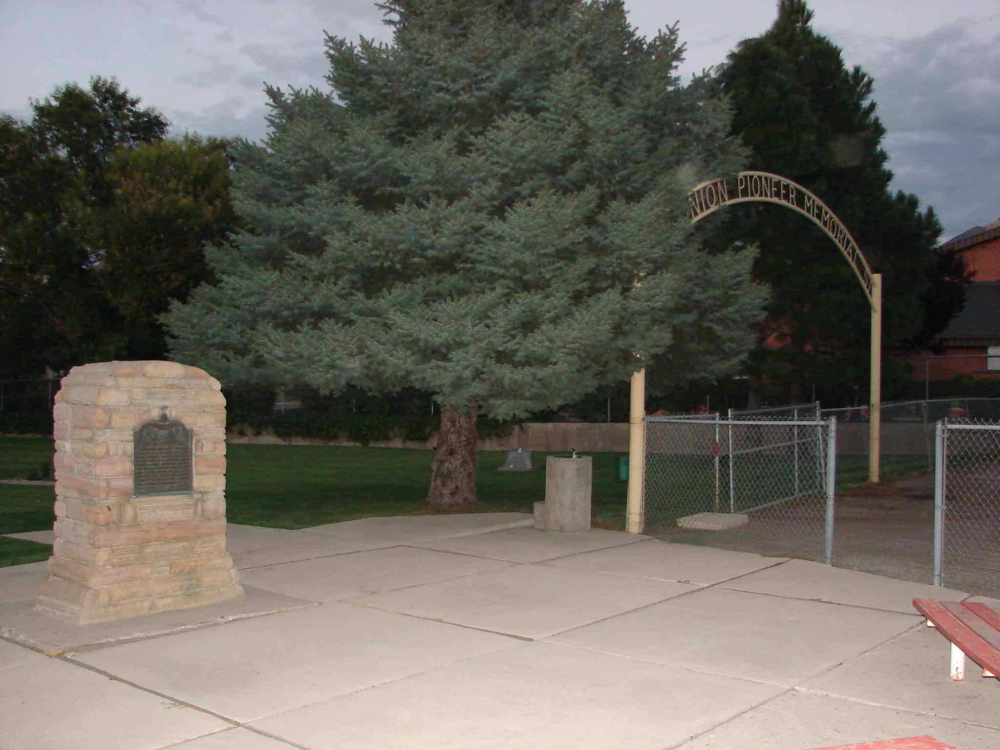
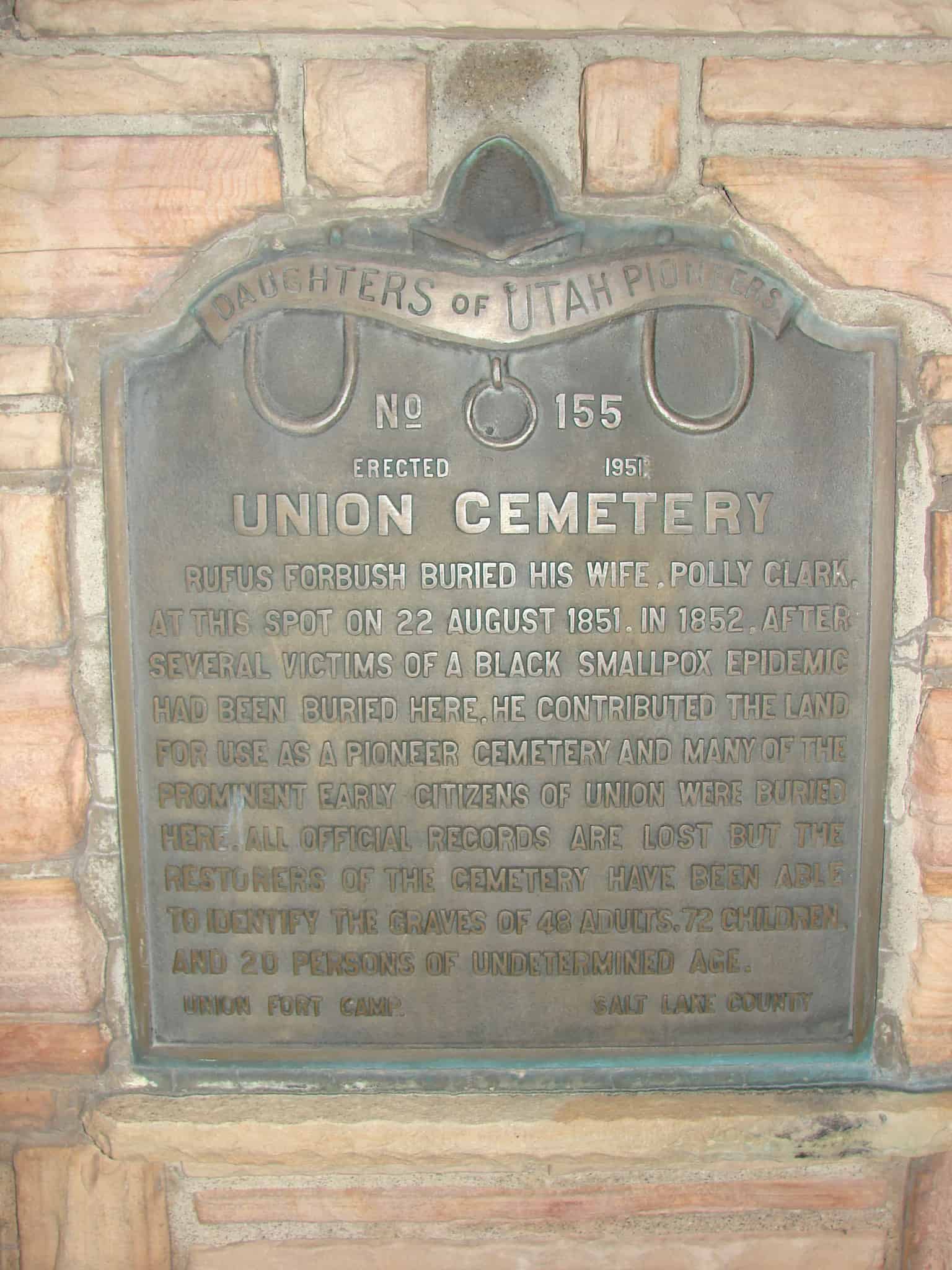
Rufus Forbush buried his wife, Polly Clark, at this spot on 22 August 1851. In 1852, after several victims of a Black Smallpox epidemic had been buried here, he contributed the land for use as a pioneer cemetery and many of the prominent early citizens of Union were buried here. All official records are lost but the restorers of the cemetery have been able to identify the graves of 48 adults, 72 children and 20 persons of undetermined age.
See also:

Check out all of the historic markers placed by the Daughters of Utah Pioneers at JacobBarlow. com/dup