Tags

Snyder, Utah

15 Friday Mar 2024
Posted in Uncategorized
Tags
Snyder, Utah
15 Friday Mar 2024
Posted in Uncategorized
Tags
15 Friday Mar 2024
Posted in Uncategorized
Tags
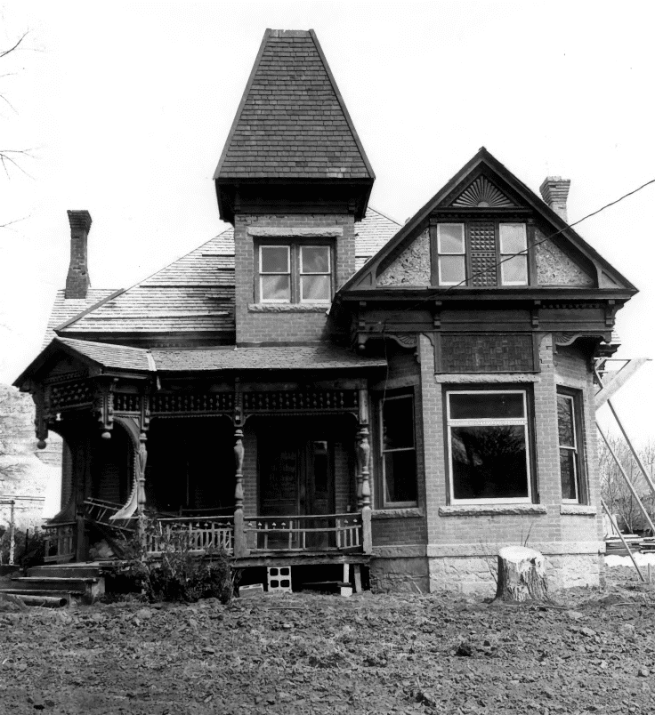
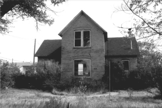
Bowman-Chamberlain House / McAllister Home
The significance of this home lies both in its architecture and its occupants. The architectural significance has already been noted in section 7 B. The site passed through a number of hands before it was purchased by Henry E. Bowman .April 30, 1892, It was he who had the present dwelling constructed. Bowman arrived in Kanab in 1885 where he taught school. In 1887 Henry E, Bowman bought an–adobe house faced with brick at 2nd North and Main in Kanab, It was in this home that Bowman began his mercantile business in the 19 x 21 ft. living room. In 1892 H, E, Bowman and four other residents formed a corporation called the Bowman Company, At this time they built a brick building on the corner of Center and Main, It wasn’t until 1894 that Bowman sold the adobe home mentioned above, at which time his new home was probably completed. It is not known who designed the home or if an architect was used, Bowman operated the mercantile business until 1896 when he sold both his home and the business to Thomas Chamberlain in order to raise the funds to go on a mission for the Mormon Church to Switzerland, He was president of the Swiss Mission from 1898 to 1900, Upon his return, he went to Mexico, returning to Kanab in 1916 and acquiring the Bowman Company once again. Bowman was responsible for the construction of the road connecting Kanab and Orderville to the north which required hauling clay and gravel by team to cover the sand which stretched between Kanab and Orderville, This highway was later to become part of Highway 89,
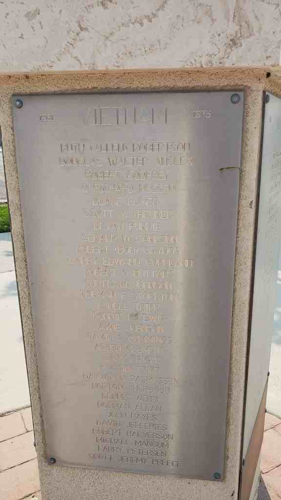
Located at 14 East 100 South in Kanab, Utah and added to the National Historic Register (#75001811) on July 8, 1975.
On November 28, 1896, Thomas Chamberlain acquired the Bowman house for $5,000. Chamberlain was among the first settlers of Orderville arriving in Long Valley in 1871, He was among the first to join in the United Order, a Mormon cooperative effort which was particularly successful in Orderville, He was designated bishop of the Qrderville Ward in 1877 and was one of the original High Councilors in the Kanab Stake, He was on the Board of Directors of the United Order serving for nine years as its president, Chamberlain had six wives and fifty-five children. He served six months (1888-9) in the Utah penitentiary for polygamy, His first wife, Elinor Hoyt Chamberlain, resided in the home until 1935, when it was acquired by her daughter, Lillian C, McAllister, Her husband, June McAllister, continued to live in the home from 1956 until his death, at which time it was sold by his estate to the city of Kanab, Kanab citizens are now engaged in a restoration project which has received funds from the State Bicentennial Commission, Plans for the building include museum space as well as a meeting place for the local historical society and other groups.
13 Wednesday Mar 2024
Posted in Uncategorized
Tags
Woodruff Stake House / Woodruff Stake Tithing House
Completed in 1901, the Woodruff Stake House is locally significant as the only remaining historic building in Woodruff that represents the Mormon Church and its strong influence in the community. The church’s principal building, the chapel or meetinghouse, was demolished in the mid-1980s. The stake house served as offices for the local ward (congregation) as well as the regional stake, which is comprised of several wards. The bishop of the Woodruff Ward occupied the north wing of the building from 1901 until 1949, and the president of the Woodruff Stake had his offices in the south wing throughout that same period. The building also served as the ward “tithing office,” the place where church members settled their voluntary contributions of one-tenth of their annual “increase,” and as a meeting place for the women’s Relief Society. The community used the building for nonchurch purposes as well, including meetings for organizations such as the local livestock association and for school purposes when space was needed. It is the only remaining civic-use building in Woodruff. The building is one of twenty-seven tithing offices remaining in Utah, as documented in the 1985 National Register of Historic Places thematic resource nomination of Tithing Offices and Granaries of the Mormon Church.
Located at 50 South Main Street in Woodruff, Utah and added to the National Historic Register (#00001586) on December 28, 2000.
Woodruff is a small, livestock-based town in extreme northeastern Utah near the borders of both Idaho and Wyoming. Though the town is actually much closer, geographically, to the Wyoming hub-town of Evanston than to any Utah city of substantial size, its history is deeply embedded in Mormon-settled Utah. The town was settled in 1865 as part of the Mormon Church’s systematic plan to establish settlements throughout the Utah region after relocating here from the Midwest in 1847. The town’s name is derived from one of the prominent early settlers in the region, Wilford Woodruff, who later served as president of the Church of Jesus Christ of Latter-day Saints (Mormon or LDS Church) from 1889 until his death in 1898.
The decision to construct the stake house was made by leaders of the LDS Woodruff Stake (a stake is comprised of several wards or congregations) on March 10, 1900, and work commenced on March 17. Church headquarters contributed $400 toward the cost of the building, and the balance was covered by the Woodruff Ward and wards from other towns in the stake. A local history of the town notes that the building contained “a clerk’s office, a High Council Chamber [apparently the center room on the main floor], a Bishops Office and also a room upstairs for a prayer circle.” The “clerk” referred to was the stake clerk, who kept track of stake affairs under the direction of the stake president. In February 1901, a local correspondent to the statewide Deseret Evening News noted that “[W]e have a fine Stake house office, with five rooms nearly completed. It was built by contributions from each settlement, and is a credit to the people of this Stake.” The fifth room referred to in this article is probably the small, windowless room adjoining the upstairs prayer room. This small room may have been used to store sacred clothing used for the prayer circles, an activity now reserved only for temples, the most sacred of Mormon structures. It was more common in the late-nineteenth and early twentieth centuries for remote communities to perform some of the lesser temple functions, such as prayer circles, in non-temple facilities.
Though the building was usually referred to locally as the “stake house,” it was sometimes called the stake tithing office as well. Tithing offices or bishop’s storehouses, as they were also known, were built in most Mormon settlements as a place to accept contributions from ward members. Through the nineteenth century those contributions were usually “in-kind” farm commodities such as eggs, hay, livestock, and so forth. Tithing yards of the period included granaries, barns, and corrals to accommodate these contributions.
In Woodruff the tithing lot and granary were established in 1891 and “located west of and adjoined to John M. Baxter’s home.” (These tithing lot structures are no longer standing.) Baxter was the bishop at the time and later served for 38 years as stake president. Though most tithing lots were usually separate facilities, it was not uncommon for them to be located on the bishop’s property. Even after the task of settling tithing accounts shifted to the new stake house, the tithing lot remained in its former location; there never was a granary, barn, or other such facility on the stake house property. The stake house was constructed during a period in which tithing throughout the church was undergoing a transition from in-kind contributions to cash payments, so there was less of a need for the traditional tithing lot structures. Eventually in-kind contributions ceased altogether.
The Woodruff Stake House is unusual in that it was both constructed and used by both the ward and stake. Most tithing offices were simply ward structures. While there are probably other examples of this dual use, it was not the norm. The building is also unusual in that it continued with its original use until 1949. By mid-century, most other wards and stakes had long since moved their offices into newer or remodeled meetinghouses and either sold their tithing offices or allowed them to be used by auxiliary organizations.
The building’s temple-form design is much more representative of 1870s Utah architecture than it is of early 20th-century buildings. Shortly after the completion of this building, the LDS Church apparently came out with standard plans for such buildings. Tithing offices constructed in a number of Utah communities after 1900 represent some of those standard plans. By 1910, however, the construction of tithing offices appears to have been terminally suspended. The new concept was to consolidate all activities under one roof. The new church buildings that emerged in the 1920s were much larger than the earlier meetinghouses because they not only included a chapel but also a bishop’s office, classrooms, women’s Relief Society meeting room, and amusement/recreation halls.
The church’s women’s organization, the Relief Society, also used the building for its meetings. This is somewhat unusual given that most ward Relief Societies preferred having their own building. The nineteenth-century pattern of separate buildings for the various ward groups and functions changed in the early twentieth century, and by the 1920s new meetinghouses included those various functions under one roof.
The Woodruff Stake House served other non-church purposes as well. It served briefly as a home for Savannah and Marie Putnam after their home burned to the ground on March 2,1917. The first and second-story rooms accommodated school children for a year when the town’s school was overcrowded in the late 1920s. It also served as a meeting place for the Woodruff Livestock Association and very likely was used for town meetings as well, since there was not a town hall. Besides the stake house, there are no other civic or public buildings remaining in Woodruff from the nineteenth or early twentieth centuries.
In 1949, with the completion of major additions to the LDS meetinghouse, the ward and stake moved out of the stake house and decided to sell the building in order to help pay for some of the cost of the new facility. According to county records, Woodruff Ward sold the building in February 1950 to Osro and Fuchsia Cornia, who owned it for three years. They sold the house to Al and LaVerl Miller in January 1953. The Millers, who are generally credited with converting the stake house into a residence, owned it until 1971. Subsequent owners include Frank and Helen Shelby (1971-75), Ralph and Sally Eastman (1975-95), and the current owners Jef T. and Gayle Jensen. The house is currently vacant and for sale.


The Woodruff Stake House, constructed in 1900-1901, is a late example of the temple-form type that was typically constructed in Utah during the 1850s-1870s. The symmetrically composed brick building faces west and features a two-story central section with its gable end facing the street, characteristic of the temple form type, and flanking one-story wings on either side. Despite a few relatively minor alterations to both the exterior and interior, the building retains a significant amount of its historic integrity.
True to the classical origins of the temple form type, the building features a symmetrical facade. Windows are centered in the central gabled section, and the flanking wings contain a mirrored door/window arrangement, though both doors were enclosed in the 1950s after the building was converted to residential use. Other changes likely made at that time include the removal of Victorian-style porches in front of both one-story sections (see historic photo) and the replacement of the original paired double-hung window on the first-story facade with a c. 1950s window (though the overall size of the opening has not changed). The open porch on the rear was probably constructed or expanded in the 1950s, given its flat roof and open-rafter construction; its turned columns may have been recycled from the front porches. The foundation of the building is randomly laid fieldstone, and the walls are constructed of locally manufactured brick. Though the Victorian porches are now gone, vestiges of that stylistic influence include the segmental arches over the windows and the lathe-turned porch columns and single engaged column at the southwest corner that may have supported a sign for the building.
The interior contains three main rooms on the ground floor corresponding to the three sections visible from the exterior and a room upstairs in the central two-story section. There is also a small “attic” room above the north wing, though inexplicably there is not a matching room above the south wing. The upstairs is accessed by an unusual, enclosed frame stairway attached to the back of the building. This stairway, which is almost certainly original, includes a coal room on the north end of the ground floor under the stairs, accessed only from the exterior. The north wing on the main floor was divided into two rooms in the 1950s or ’60s to accommodate a bathroom after the building was converted into a home. Built-in propane heaters were installed in the corners of the rooms at about that same time. The ceiling height and woodwork have been retained on the interior. Those are the only alterations of note to the interior.
The stake house is located on Main Street (State Route 16) in Woodruff, a block north of where the LDS meetinghouse was located. Both in scale and setback from the street, the building is more typical of residential buildings in the community, as opposed to institutional buildings.
Also located on the property (at the northeast corner) is a frame single-hole outhouse constructed by the WPA in the 1930s. It has a shed roof, drop siding with 1×4 corner boards on the exterior, and distinctive WPA features on the interior, such as a concrete base and riser set diagonally in a rear corner, metal vent pipe, and a rectangular wooden lid and latch to hold it in an upright position. Though it is possible this outhouse was moved in later, it is more likely that the structure was built to serve the needs of this building. It is considered a contributing building on the property. Noncontributing features include the flagstone, freestanding outdoor fireplace behind the building and the flagstone planter box that replaced the porch in front of the north wing.
13 Wednesday Mar 2024
Posted in Uncategorized
Tags
Daniel Heiner House
The Daniel Heiner home in Morgan is a distinguished pioneer residence that marks the local importance of a man who, in peculiarly Mormon fashion, combined a life of religious leadership with active entrepreneurial activity in ranching, mining, and banking, as well as significant involvement in Republican politics.
Located at 543 North 700 East in Morgan, Utah and added to the National Historic Register (#78002664) on December 20, 1978.
Daniel Heiner was born November, 1850, in Pennsylvania to German immigrant parents. After conversion to the Church of Jesus Christ of Latter-day Saints, the Heiner family migrated to Utah in 1859. With ten members in the family, together with all their belongings, there was no room on the one wagon for eight year-old Daniel Heiner….so he walked the 1,000 miles from Council Bluffs, Iowa.
ollowing some years of hardship, during which he worked as a shepherd )oy, Daniel finally settled with his family in Morgan county. During these early years he helped support his family through hunting and leading hunting parties and by working as a laborer on the Union Pacific Railroad. Despite his almost total lack of formal education, Heiner was literate and intelligent and eventually at age 22 he was called as the village schoolmaster in Morgan.
In 1873 Heiner married both his brother’s widow and a virgin of his choice, and in his biography later noted that following the double ceremony in the Salt Lake Endowment House he had exactly two dollars to his name. However, it was not long before his energy and initiative had created a family ranching business that he maintained throughout his life. In addition he managed Echo Land and Livestock Company for 15 years, and bought and sold cattle on behalf of the Whitney § Chambers Company of Evans ton, Wyoming. In commenting on his vigorous business instincts, Heiner remarked that he could never “content myself by killing time.” Every activity had to be turned to good account, and for example, “When I was riding horses over the country I would notice the kind of grass, brush, or timber that I was going through. If I passed a grove of timber, I would figure out mentally how much lumber could be sawed out of the grove, by guessing how many acres in the grove, how many trees to the square rod, and how much lumber could be cut out of an average sized tree.”
The family fortune from mining, principally coal and silver claims, was the result of this eagerness to work and achieve. “I went down there (Emery County) four or five times and climbed over the high mountains following coal measures and survey lines while my neighbors were sitting by the fire warming their shins. I succeeded in getting twelve of my children (he had nineteen) located on coal claims, which are now know as the Black Hawk coal mine, about the best coal mine in the state.” Growing out of his mining and ranching activity was Heiner’s interest in banking which led to the creation of the First National Bank of Morgan of which he was President for 16 years.
Describing himself as a “natural Republican,” Heiner served in a number of local political offices, and was mayor of Morgan City for two years. Following service in the first state legislature, Heiner was then appointed as road commissioner for Morgan County. In this role, he had several significant accomplishments in road and bridge building.
Keeping pace with his growing prestige in the secular world, Heiner’s role in the Mormon Church grew increasingly more responsible. As a polygamist he narrowly escaped prosecution, being saved from being brought to trial by the timely announcement of the Manifesto which had the effect of halting active prosecutions of polygamists under the Edmunds-Tucker Act. Although he did not join the distinguished group of Mormon Church leaders serving time as “prisoners for conscience’s sake” in the territorial prison, Heiner had gained that extra measure of responsibility, from a Mormon point of view, which probably ensured his eventual selection as President of the Morgan state (akin to a diocese) of the Mormon Church. He served in that position for twenty-three years.
Daniel Heiner was preceeded in death by the two wives who had given him nineteen children. Before his own death in 1931, at his home in Morgan, he was married to his nurse, Barbara Wheeler.
The Heiner Home, like the man, is a measure of the sturdy values of pioneer enterprise and its solid construction and innate style a fitting memorial to a man who made contributions to his community through business, politics, and religion.
The Daniel Heiner house is a very well maintained five-over-five I-form central hall house. A two-story porch runs almost the full width of the house, with the porch columns matching the five-part division of the façade openings. Although the jigsaw scrollwork brackets on the sides of the columns are missing, the porch railings and balustrades are in excellent condition. The stucco walls were originally scored to give the appearance of cut stone; they are now painted slate blue. The shingle roof has been covered with neutral colored asphalt shingles.
The house stands on the edge of a valley and commands an exceptional view of valley farm lands and mountains. A number of pioneer residences, differing in style, are strung out along a country road. Unfortunately, they are interspersed with modern dwellings.

13 Wednesday Mar 2024
Posted in Uncategorized
Tags
Coombs Village Site
The Coombs Site appears to have been the largest settlement along the southern slopes of the Aquarius Plateau; as such, it must have exerted considerable influence on peoples residing in its immediate environs. Large open sites are not common in this area or In the adjacent areas which have been subject to investigations (e.g., the Kaiparowits Plateau, the Escalante River drainage, the triangle area between the San Juan and Colorado Rivers, and the right bank tributaries of the Colorado). Excavated sites simply do not approach the Coombs Site in complexity of architectural form, wealth of artifacts, amount of refuse, or sheer size.
The Coombs Village Site is part of Anasazi State Park Museum at 460 North Highway 12 in Boulder, Utah and was listed on the National Historic Register on (#76001815) on January 1, 1976
The analysis of the large quantity of data recovered during excavation of the site is extremely significant, in that it shed considerable light on our understanding of various aspects of prehistoric lifeways, and the relationship of various groups over a wide geographic region. On the basis of pottery analysis, the site is believed to have been occupied for a relatively short period of time from A.D, 1075 to perhaps 1150, by a population of approximately 200 people.
The village is believed to have been established by people from the San Juan drainage to the southeast. The ceramic assemblage from the site is strongly affiliated with the Kayenta region. However, based on the amount of Fremont ceramics, there was also considerable contact with Fremont populations. There is also evidence for contact with the Virgin, Mesa Verde, and Chaco areas, based on ceramic as well as other kinds of evidence.
The reason for the abandonment of the site after a short period of time is not known. Ultimate cause may be associated with fire. It is postulated that a major holocaust spread through the village at its termination. “Whether it was a result of conflict, accident or intentional action we cannot state, although the latter seems most probable. The town was never reoccupied. The Coombs site is but one more example of the burning of Anasazi villages in the San Juan. Morris (1939, 41-2) has written of the great frequency of burning in archeological sites in the La Plata area.” (Lister and Lister 1961I:I0).
The Coombs Site (42GA34) is a 12* century Ancestral Puebloan (Anasazi) habitation site located at Anasazi State Park Museum in Boulder, Utah. Cumulatively, excavations over the past half-century have yielded approximately 162,000 artifacts distributed across nearly 100 room structures. Dendrochronological data indicate that the site was constructed at latest by about A.D. 1160 (Marwitt and Fry 1973) and was occupied until approximately AD 1235.
Three types of architecture have been identified at this site: jacal, Kayenta masonry, and pit structures (Lister and Lister 1961). hi addition, one example of a four-post roofed shade, or ramada, was identified on the southern slope of the site (Lister 1960). A minimum of two distinct pueblo units, one L-shaped and one U-shaped, were also identified. These consist of both habitation and storage units, while additional isolated habitation and storage units are scattered across the site. In addition, ten pit structures have been excavated on the southern slope of the site. Features within the pithouses suggest they were likely used for habitation rather than ceremony, thus the reference to them as pithouses rather than kivas (Lister and Lister 1961). To date, no confirmed kivas have been identified at the Coombs Site.
Estimates suggest that although the major structures have been identified, only about 50 percent of the site has been investigated. In fact, outlines of unexcavated rooms are visible across the site. Excavations conducted since the Park opened in 1970 have modified our interpretation of the site structure and future excavations will undoubtedly modify it further. A full re-recording of the site is currently in progress.
Based on architectural forms, artifact types, and the ceramic assemblage retrieved from the site, the original interpretation of the site places it firmly within the Kayenta branch of the Anasazi (Lister 1959; Lister, Ambler, and Lister 1960; Lister and Lister 1961). The presence of intrusive ceramic wares, as demonstrated by design elements and temper type, indicate contact with neighboring Virgin Anasazi and Fremont peoples (Lister and Lister 1961). A small percentage of Mesa Verdean ceramics also suggests contact or trade with that distant center (Lister and Lister 1961).
In 1889, Sam Sheffield established a homestead just southeast of the prehistoric village and before long discovered the “Indian Mound” (LeFevre 1973). From the pottery, projectile points, and grinding stones he found on the surface, Sheffield believed the site to be a burial ground of a more ancient group than those he had previously encountered in Utah.
The site attracted little attention from the early residents of Boulder, although they sometimes collected “arrow heads” and other stone tools, metates, manos, and pottery sherds. As Boulder developed, so did construction activities and the resulting knowledge of the presence of an “Indian Mound.” Morss (1931) reported that some burials had been uncovered when the southern slope of the site was being used as a “sand pit.” Lister (1959) indicates that widening of a road along the base of the hill exposed additional burials and cultural material, thus stimulating local pot hunting activities at the site. Despite these non-archaeological collecting activities, the majority of the site deposits remained relatively undisturbed.
Professional archaeological investigations at the Coombs Site were initiated in 1927 when members of the Claflin-Emerson Expedition of the Peabody Museum visited the site (Morss 1931). Although primarily a reconnaissance program, the Expedition prompted Peabody Museum personnel to initiate a program of survey and excavation a year later (Gunnerson 1969). Directing work in this geographic area was archaeologist Noel Morss, who tested the Coombs Site in 1928 and reported his findings in 1931. Morss (1931) identified the remnants of several masonry rooms at the top of the hill, and described the finding of three burials in a sandy drift along the southern slope of the site. Morss reported that the burials were in a flexed position and all skulls were occipitally deformed. He also described mortuary offerings found with the remains, primarily ceramic vessels (Morss 1931).
In addition to the vessels from the burials, Morss collected a sample of sherds for analytical purposes. The vast majority of pottery was corrugated, followed by black-on-white, red ware, polychrome, and plain gray sherds. He identified the pottery as “Proto-Kayenta,” or what is now called Tusayan ware, concluding that pueblo peoples occupied the Coombs Site, whose material culture resembled that of the Kayenta peoples in northern Arizona. Morss also noted that the material remains at Coombs differed from those of the Fremont culture to the north.
LeFevre (1973) indicated that a “Dr. Kerr, a Utah professor,” also conducted a small excavation in 1928 with the assistance of local residents. LeFevre reports that a skeleton was exhumed and put on display at the University of Utah.
In 1955, the Coombs Site was examined and recorded by James H. Gunnerson as part of a reconnaissance conducted by the Utah Statewide Archaeological Survey for the Department of Anthropology of the University of Utah. Because Gunnerson’s primary research concern at that time was the Fremont culture, little was said about the site except to note that the artifacts from the site did not resemble those of the Fremont. Gunnerson recommended that no further work be conducted at the site (Gunnerson 1955).
Despite Gunnerson’s recommendation, extensive excavations would begin three years later as an adjunct to the 1957 Upper Colorado River Basin Archaeological Salvage Project. Participants in the project failed to locate any sites in the Glen Canyon area that would compare with the Coombs Site either in size or in volume of cultural remains. Additional importance was assigned the site because of its intermediate position between the Anasazi in the south and the Fremont to the north (Lister 1959). The 1958 excavation succeeded in uncovering three distinct structures, a borrow pit, three burials, and thousands of artifacts. The excavations verified the importance of the site to the prehistory of the area. Subsequently, plans were formulated-even before the 1958 excavation was completed-to return during the summer of 1959 to continue investigations (Lister et al. 1960).
The 1959 season revealed a much larger portion of the site than had been exposed in 1958. Excavations continued in those areas explored in 1958 and expanded into other portions of the site. Twelve additional exploratory trenches were opened, which identified 12 surface structures, 10 pit houses, 11 burials, and several miscellaneous structures. As with the 1958 excavation, thousands of artifacts were recovered and analyzed (Lister, Ambler, and Lister 1960).
Following the 1959 season, all structures were covered with plastic and backfilled in anticipation of including the site in the Utah State Park system. The results of the University of Utah excavations have been published in three volumes that comprise the original Coombs Site Report (Lister 1959; Lister et al. 1960; Lister and Lister 1961). In all, the University of Utah excavations identified 77 masonry or jacal rooms, 10 pit houses, one ramada, and 14 burials.
The site was designated a State Park in 1960 after the State, the town of Boulder, and Garfield County purchased the private lands containing the ruins. Prior to the construction of the Visitors Center, the University of Utah conducted a magnetometer survey and limited test excavations in 1969 (Hammond and Marwitt 1970). As a result of these investigations, the location of the Visitors Center was moved to avoid a pit house and extramural activity areas. The visitor center opened in 1970 and the Coombs Site became the first State Park featuring archaeology and archaeological ruins. Subsequently, the site was placed in the National Register of Historic Places in 1976.
Small-scale excavations were conducted intermittently between 1970 and 2002 under the supervision of Anasazi State Park staff. These investigations, in conjunction with laboratory analyses of the collections (Morgenstein and Latady 1997; Prince et al. 1997; Roberts 1997), identified several additional structures and a number of burials. A more thorough discussion of the site history is provided in a number of sources, listed in the bibliography below.
13 Wednesday Mar 2024
Posted in Uncategorized
Tags
Simmons Ranch
The Simmons (Remund) Ranch has significance as an intact, excellent, and representative example of an early Homestead; quite possibly the first Homestead, in Duchesne County. As such it is the oldest surviving site of European/American settlement, in this area, formerly part of an Indian Reservation, which was opened to such settlement in the early twentieth century. This site has additional significance since the homesteader succeeded while most others in the locale failed in similar endeavors.
The Simmons Ranch is located along the Strawberry River in Duchesne County, Utah and was added to the National Historic Register (#92000463) on August 18, 1992.
An archaeological team from Brigham Young University examined the Simmons (Remund) Ranch complex (district) in late 1990 and prepared a report on buildings and structures extant at that date. They found an older part that consists of five buildings of “log cabin” construction, as well as a system of corrals, a pavilion, an underground storage facility, an irrigation ditch, and a barbeque pit. The last five items fit into the category of structures. In the western part of the area stand three other cabins and one house of “poverty siding construction,” a external wallboard or plywood material. These cabins and house were transported to the present location, hence they are “noncontributing” though they were a later part of the functional ranch.
The largest of the buildings of the “log cabin” construction stands at the southeast cornpr of the group of buildings of the ranch and measures 30 ft. by 15 ft. and consists of two rooms. This building includes a front porch, gabled roof, and stone foundation. The roof is of planks with a tin exterior added to the east side only. A loft or attic with exterior opening for entry is present which is accessable from a ladder on the outside of the cabin. The hand hewn and notched logs suggest an early date of construction. The cabin has two doors into the two rooms from the exterior on the west side and two windows on that side. One of the doors is partially missing but was a solid exterior door. The other is missing completely but a screen door is still in place on the outside. A single door on the east side is gone completely. One window on the first floor is on the north side below the opening to the loft. The county tax assessor’s office has a record which indicates that the cabin may date from as early as 1910 but the best estimate, as described below, is that it dates from approximately 1920.
A second “log cabin” appears on the map sketch as having additions on both the north and south. An original portion of this second “log cabin” of 15 ft. by 13 ft. provided the basis for the building with the portion on the north side marked “addition” on the map representing an extension of the interior. The addition made the entire “log cabin” some 28 ft. by 13 ft., not counting a plywood porch 10 ft. by 10 ft. shown on the map as a second “addition.” The original cabin had only an entry door but the plywood porch also has a door and three windows across the south end and one window on the west end. the addition on the north end simply lengthened the original building with no more doors and windows. A plywood façade of later date covered the logs but has fallen away enough to reveal underlying logs. The roof consists of dirt and sod materials, which are now bearing grasses. The additions are more than 50 years old so they are considered “contributing” to the nomination. Neither of the two larger “log cabins” designed for residence (nor any of the later poverty sided cabins) include any heating facilities.
Three additional “log cabins” are described as connecting storage sheds, each 13 ft. by 10 to 12 ft. The two sheds at the ends of the group probably originated as separate buildings. Logs placed between the original sheds formed the third shed. The eastern most of the three sections is of construction suggesting use as a granary with a door opening about 1 and 1/2 feet (the width of three logs) above the ground. The door itself is simply planks nailed to braces. The cabin at the west end has a single door opening which is at ground level with another door consisting of planks. The roofs of all three sections consist of dirt and sod materials. However, the logs of the middle shed show clear evidence of machine sawing, implying a somewhat later date, though, as described below, all three can be reasonably documented as having been on the site by 1913. The middle shed has no exterior doors but is entered through a door opening from the western most shed. A small door covering a hole in the ground stands just east of the three connected cabins.
A system of corrals at the north end of the complex is also of axe hewn log construction as is a fence which encompasses the entire ranch complex. The western portion of the corrals, in a circular shape, suggests that is was designed for horses. The eastern portion of the corrals which consist of parallel logs suggests use for cattle or other livestock. A portion of an irrigation ditch runs along the southern edge of the corral just north of the log sheds. All of the log construction is of hardwoods which were of the same species currently present along the stream. The most important is the box elder, a member of the maple family and quite common in the area. However, cottonwood trees, less useful for construction, are also present in numbers.
A small structure noted as a pavilion of 20 ft. by 15 ft. has a gabled roof of wooden frame construction, supported by upright logs, but no walls. Next to the pavilion is a circular plaza approximately 15 ft. in diameter which consists of flat stones. The stones surround a porcelain bathtub sunken to the ground level which served as a barbeque pit. A proper description of this feature is also that of a structure rather than a building. Neither the pavilion and the barbeque pit appear on any records of the Assessor’s office but the cattle operators added them, probably in the 1940s. Hence both are non-contributing to the nomination though present in the area.
Charles Simmons completed an application to take legal ownership of the lands under Homestead Laws, on February 10, 1913. This process is also called going to patent with the document showing the government’s grant of ownership called the final patent. He presented an inventory of the improvements that he had made on the land. Two other witnesses also appeared, as required by the Homestead Laws, who substantiated the inventory and other items in Simmons’s statement. In fact, they valued the improvements at $700; Simmons himself only gave $650. Also they noted the existence a lateral irrigation ditch, that Simmons omitted. Otherwise, they gave identical inventories.
Log House, 15′ x 15′
” Barn, 12′ x 20′
Cellar, 8′ x 10′
Log shop, 10′ x 12′
Pole corral, 30′ x 50′
Chicken house, 8′ x 8′
Hog-pen, 8′ x 10′
Log stable, 14′ x 16′
Pole fence, 1/2 mile,
900-1000′ lateral irrigation ditch.
A correlation of the above listing with the buildings and structures evident on the property is useful. The later owner of the ranch who had memory of it from a very early date stated in oral interviews that nothing had been removed except the chicken house and log stable, though other buildings were added later. Hence the inventory on the patent application needs to be reconciled with the observable earlier buildings on the site. With this fact in mind it is safe to say that the cabin on the 1913 inventory of 15′ x 15′ is probably the smaller log cabin as noted with additions from later times, though the actual measurement is 15′ x 13′, the number is close enough considering the nature of the records. Records at Duchesne Co. Assessor’s Office imply that the changes were made prior to 1940, a date substantiated by a later owner of the ranch. The Barn is probably the shed designated as a granary with the shed next to it. The dimensions of 24 ft. by 13 ft. are close enough to the measured dimensions of 20 ft. by 12 ft. in the original patent.
The third shed is probably the improvement noted in the 1913 inventory as a log shop since it fits the dimensions almost exactly. The covered hole just east of the sheds may well be the cellar. The pole fence of 1/2 mile is represented by several segments of wooden fence in the area, though some may have been replaced over the years. The Pole corral is still represented by the existing corral, though, again, some portions may have been replaced and the entire structure expanded. Conceivably the Hog pen of 8′ x 10 J was also in this area at the north end of the ranch. Even a portion of a 900 J to 1000′ lateral irrigation ditch probably survives along the south end of the existing corral, though only 50 J today. Presumably the original ditch extended farther to the east into fields of various crops. The only items from the 1913 inventory which can not be readily correlated with anything still present are the Log Stable and Chicken house, though a chicken yard is present on the eastern edge of the area next to the smaller log cabin.
The inventory does not list the larger log cabin, but the later owner of the ranch stated that the cabin dates from the time of occupancy by Charles Simmons, certainly to the 1920s and possibly earlier. The Assessor’s Office listed it from 1910 but that was obviously too early. The later owner also noted that his family had brought in and occupied the “poverty sided” ranch house and smaller “poverty sided” cabins in the 1940s. Hence this group of buildings are listed as “noncontributing” to the nomination though they were a functional part of the ranch at a later date and may be added to the site as “contributing” when time requirements are met within just a few years. (Indeed, a case can be made that these additional buildings could be designated as contributing at this time since they were part of the functional ranch for many years and date before 1940; quite possibly some years before 1940.
As a final listing, the following existing items are contributing as part of the original homestead as representing the first permanent European/American settlement in the area:
The significance of the Remund Ranch as the oldest surviving European/American residence in the area of northwest Duchesne County, Utah, is documented by the records filed by Charles Simmons in the Homestead process which ultimately led to a full patent (grant of private ownership) by the U.S. General Land Office on June 26, 1913. (Rather typically, the owners did not file a copy of the patent document, no. 344144, with the Duchesne County Recorder until June 25, 1928, but it had legally been their property for fifteen years.) This is the earliest patent granted by the General Land Office under Homestead, Sale, or any other method in the entire region of the county, as revealed by the Recorder’s Office and a master file book of land patents in the National Archives. The area had been a part of the Uintah Reservation of the Ute Tribe until the early twentieth century when the General Land Office opened it to entry under the various land distribution laws. However, the Land Office did attach some additional restrictions directly into the patent that were not part of patents on typical federal lands.
The opening of previously withdrawn lands to Homestead is a major theme in the history of the Western U.S. A series of major “Land Rushes” in Oklahoma, formerly known as “Indian Territory,” have defined much of that State’s character. (Even the nickname “Sooner State” reflects the trick of a few slipping into an area “too soon” before legal opening to claim choice lands.) The U.S. Congress opened a portion of the Ute Tribes Uintah Reservation to non-Indian Homesteads by an Act of May 27, 1902. Members of the tribe selected lands: 80 acres per head of family, 40 for all other members. The purpose of opening the lands was to raise additional cash for the tribe which was “land poor.” The same act allotted some $70,064 to the tribe for various medical expenses then current. Further the Act specified that those entering the lands for the purpose of Homestead would have to fulfill the normal requirements under the famous Act of 1862 by constructing a cabin, residing on the site for five years as the only residence, and productively farming or ranching the land. However, in the case of former Ute Lands (and other former Reservation Lands opened under a variety of Acts of Congress), a Homesteader had to pay a fee of $1.25 per acre after the five years residency. In cases of “ordinary” Homesteads, the filing party could secure the land by paying the $1.25 fee per acre at anytime prior to completion of the five years but after that time the party had a two year period to file final paperwork and pay processing fees as the only monetary expense.
Though the Act opening the Uintah Reservation took effect on October 1, 1903, actual administrative enforcement of the provisions was delayed until July 1, 1905, when the General Land Office finally opened a facility to service the area. This office, at Vernal, Utah, administered a variety of government lands in the area. In the Utah case there was no dramatic “Land Rush” as had marked at least five openings in Oklahoma which have been recreated by Hollywood with claimants madly dashing over a starting line at an appointed time. In Oklahoma, large tracts of prairie with excellent wheat potential attracted large numbers of claimants from the start. On the former Ute lands, rugged topography made the great majority of the acreage useless for farming or ranching. However, there were some exceptions, including the site selected by Simmons, which was along a stream bottom. Claimants drifted into such sites over the ensuing years. Simmons was clearly one of the first to file a claim, on January 27, 1906, and take residency on June 25, 1906. It is impossible to state if he was the first to do so in the area, however, he was the first in what is now Duchesne County to actually complete the patent process, as noted above. In 1907 a large group of families arrived from Nebraska and began to improve homesteads. The Nebraskans were not alone. From July 1, 1906, to June 30, 1907, various claimants filed 331 documents for entry into former Ute lands. It should be noted that this area was considerably larger than that part of the Reservation which was ultimately placed in Duchesne County. The fact that few of these actually went to patent adds to the significance of the Simmons Homestead in this context.
The “log cabins” contribute to the theme of the site as intact, excellent, and representative examples typical of the dwellings of most early European/American residents. Though several other “log cabins” on other properties are known in Duchesne County, they have been removed from their original locations or are not as old. The prevalence of hand hewn logs in the two cabins that served as residences and two of what are now the log storage sheds is unusual for log cabins constructed by the twentieth century and is important physical evidence of the early date of settlement in the local area. Subsequent use of sawed logs at the Ranch emphasizes the significance.
The Simmons (Remund) Ranch proved successful from farming and, subsequently, from open range ranching. The popular media have frequently portrayed open range ranches, loosely described as operations which graze livestock on open, unfenced lands. However, there are relatively few such facilities in the Western States which have been so well preserved. The fact that the Ranch operated in such a capacity from its first settlement until relatively recently also adds to this aspect of its significance. The success of the Simmons (Remund) Ranch is most striking when contrasted to the operations of other immigrants who came to the area at about the same time. The Nebraska group noted earlier is particularly striking in this regard. Several families with origins in Nebraska are listed on the 1910 U.S. Census at the same time Simmons lived there. Even though the group included some well-to-do families for the times, with doctors and lawyers among the contingent, their efforts were mostly unsuccessful. Virtually the entire group returned to Nebraska before living on the parcels of land for the five years required for Homestead. Thus the date 1913 by which Charles Simmons had lived on the land long enough to fulfill the requirements for the full patent provision of Homestead, represented the approximate time that the Nebraska group was abandoning such ultimate prospect.
When Charles Simmons filed for his final Homestead in February, 1913, he listed himself as single, 31 years of age. By the time the officials in Washington approved the application in June, 1913, they issued the final patent to Charles and Hanna Simmons. This is a further testament to the success of Charles Simmons development of the ranch. The Simmonses went so far as to acquire additional adjacent lands under the Act of Congress of 1820 which allowed outright purchases (instead of the five year occupancy for Homestead). They filed for these purchases in 1917 but the Land Office did not issue their final patents until 1921, possibly because of the restrictions of release of former tribal reservation lands. The fact that the Simmonses had enough capital to make a land purchase, and chose to do so on adjacent lands, is further evidence of success.
Yet another suggestion of the success of the original Homesteader appears in his original patent application of 1913. In addition to the inventory of improvements noted in Sect. 7, Charles Simmons also presented a list of crops and acreages that he had cultivated over the years immediately prior to his final application. It should be noted that his application was for a total of 160 acres of land, considerably more than the area immediately around his cabins. He grew the following crops on the acreages noted, which totaled 25 ac. cleared and ready by 1912:
The steady increase in production is inescapable evidence of success.
The Simmonses may have leased the Ranch, or a portion of it, to a man named Hays in the 1920s or early 1930s. The recorder’s office shows a 1938 sale to H. Ray Knox and a 1946 resale to the Remund brothers, hence the Ranch name on the USGS topographic map.
However, Lloyd Remund stated that he and his brother had occupied the ranch as early as the 1930s though he could not provide an exact date. (A time lag of some years in recording of a property transfer is quite consistent with the earlier history of this particular parcel and of general practice in Duchesne County. Such a lag may also show final payment of a mortgage after some years.) The Remunds ran from 60 to 180 head of cattle. Earlier Hays had run as many as 300 goats for mohair production. Lloyd Remund stated that Hays was the builder of the circular portion of the corral since he also had horses, though some corral facilities existed in the area from the first Homestead. However, some corral facilities were clearly present earlier as shown by Simmons application. Both Hays and the Remunds had operated the ranch only in the summer. However, Lloyd Remund stated that the Simmonses had lived on the ranch year round at some times but had lived in town at others. He was uncertain as to whether they ultimately had any livestock production, though they grew crops from the initial entry. This seems consistent with the crop records through the years listed in the patent application. If Charles Simmons had produced livestock he would have listed it as well.
A final point from contemporary records on the original homesteader, Simmons, is of some interest. Charles Simmons listed himself as arriving on his homestead from Theodore, Utah. Two other homesteaders on nearby sites in 1906-1907 also listed themselves as arriving from the same community. They could well have been a loosely organized group but no conclusive support documents are available.
13 Wednesday Mar 2024
Posted in Uncategorized
Tags
The Manila petroglyphs are unique to Utah rock art, and resemble no other known panels in the state. Schaafama (n.d. :59) considers the site to be an example of the Plains Interior Line Style, which would make it the only one of this style in Utah. Day and Dibble (1963:14) point out that while some of the elements found in the panels are often assigned to the Fremont Culture south of the Uintah Mountains, these motifs are commonly found on the Northwest Plains also. In addition, the numerous phallic representations found on the Manila panels appear to be more characteristic of the Northwest Plains rather than the rock art found south of the Uintah Mountains.
Thus, it would seem that this rock art is most likely associated with prehistoric hunting and gathering cultures to the north of Utah. It should be noted, however, that the panels themselves do not closely resemble most of the published rock art to the north, and thus stand at present as unique examples of aboriginal art.
Located at Manila, Utah in Daggett County, the site was added to the National Historic Register (#75001802) on October 6, 1975.
The site consists of a 200-foot long, discontinuous petroglyph panel of anthropomorphic, zoomorphic and geometric figures. These figures have been deeply pecked into the mineral-stained faces of escarpment boulders and fallen boulders below the cliff, all of which are part of the Dakota sandstone formation. The outstanding elements In the panels are the large anthropomorphic figures (approx. 3 to 4 ft. high) which have intricate line designs in their interiors. They are rectangular in form, with prominent phalli. In addition, there are numerous small stick-figure anthropomorphs, and animals done in the same manner; these Include mountain sheep, bison, and deer (or elk). Involved abstract designs are present–concentric circles, zig-zags, wavy lines and other motifs. Extensive camping sites are associated with the petroglyph panels. Heavy concentrations of lithic materials are present both above and below the boulders on which the art is located. There is a small spring only a few hundred yards below the panels (i.e., to the south), which may have been an important factor In the location of the art work and camp sites.
At present, the site appears to be in excellent condition with the exception of a few initials and minor shooting (using the concentric circles for target practice). No new vandalism was noted in 1975 from the time the site was first recorded in 1962. The road which runs immediately to the south of the site is now closed, making access more difficult, and probably providing more protection from vandalism.
12 Tuesday Mar 2024
Posted in Uncategorized
Tags
11 Monday Mar 2024
Posted in Uncategorized