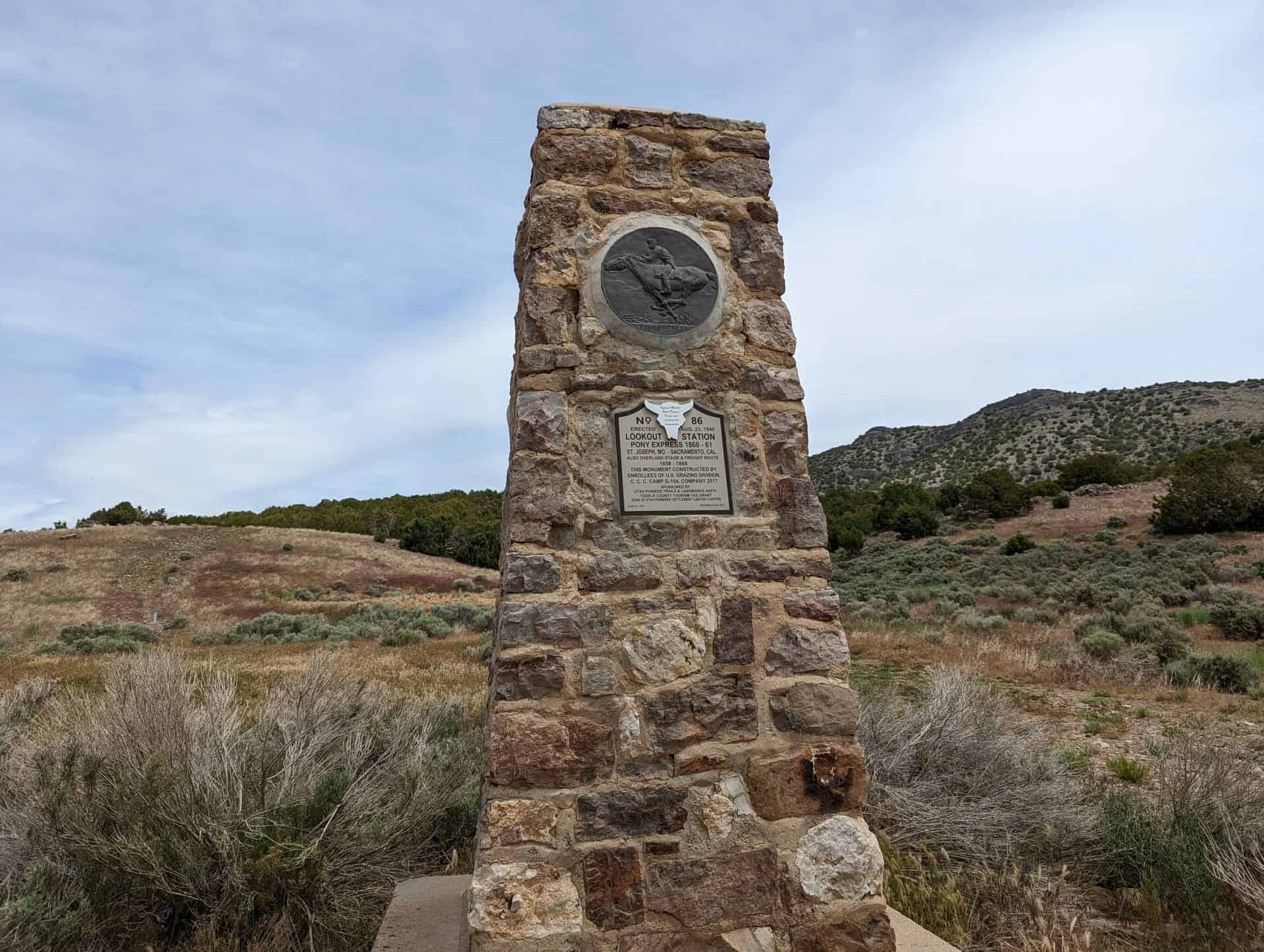
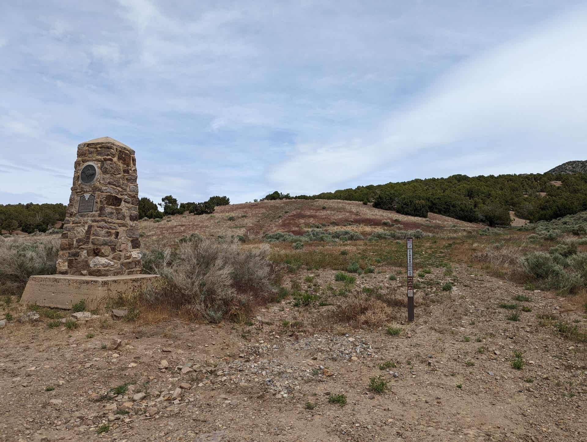
Lookout Station Pony Express – 1860-61 St. Joseph, Missouri – Sacramento, California Also Overland Stage & Freight Route 1858-1868
This monument was constructed at Lookout Pass by enrollees, U. S. Grazing Division, C. C. C. Camp G-154, Company 2517 on August 23, 1940 and sponsored by the Utah Pioneer Trails and Landmarks Association (#86 of their monuments) it was later adopted by the Sons of Utah Pioneers (#235 of their monuments) and rededicated in 2017.
St. Joseph, Missouri to Sacramento, California 1860-1861
This monument was constructed September 3, 1934 by citizens of Ibapah and by the Utah Pioneer Trails and Landmarks Association (it is #47 of their monuments) it was later adopted by the Sons of Utah Pioneers and is located in Ibapah, Utah.
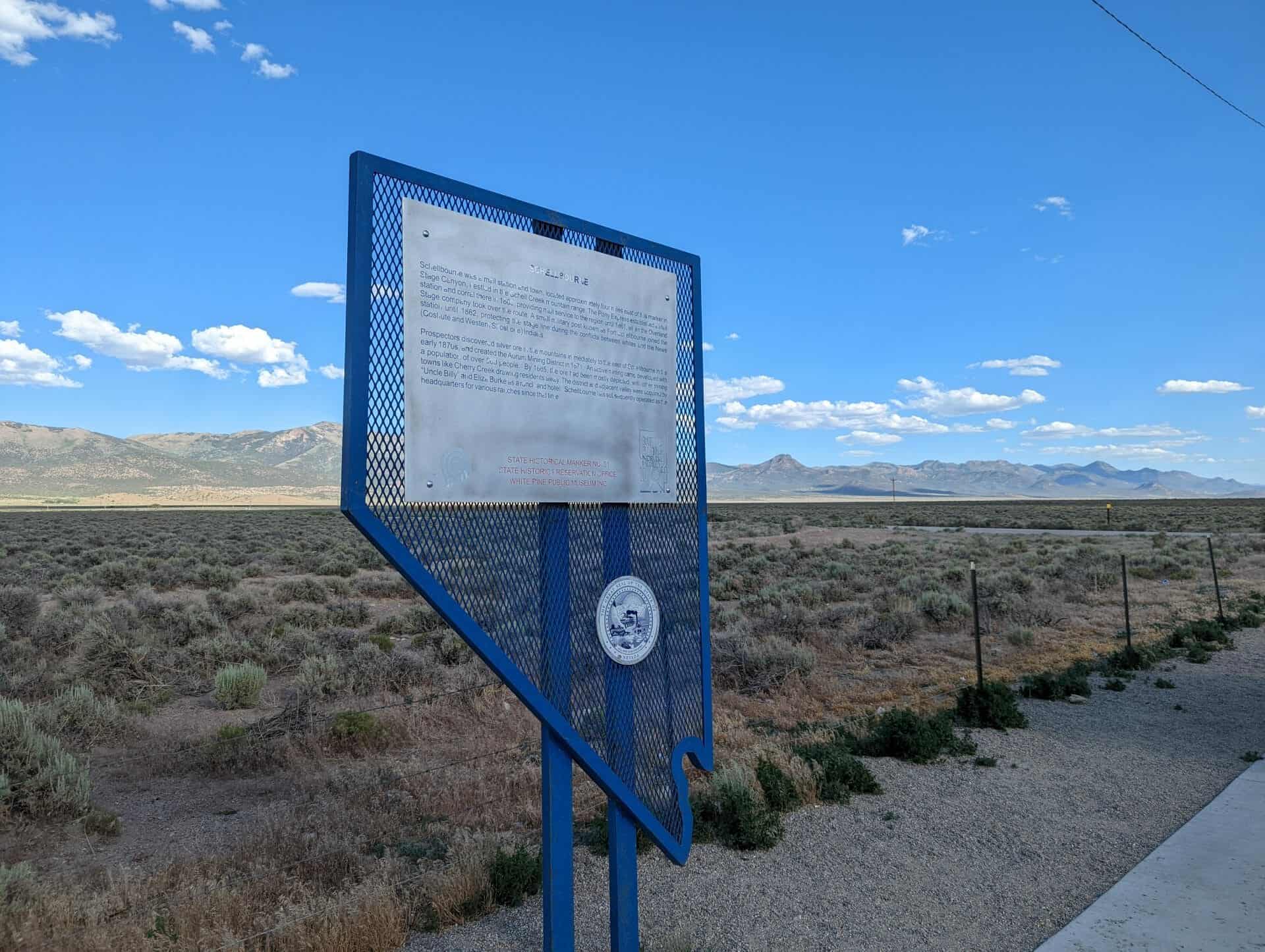
Schellbourne was a mail station and town, located approximately four miles east of this marker in Stage Canyon, nestled in the Schell Creek mountain range. The Pony Express established a mail station and corral there in 1860, providing mail service to the region until 1861, when the Overland Stage company took over the route. A small military post known as Fort Schellbourne joined the station until 1862, protecting the stage line during the conflicts between whites and the Newe (Goshute and Western Shoshone) Indians.
Prospectors discovered silver ore in the mountains immediately to the east of Schellbourne in the early 1870s, and created the Aurum Mining District in 1871. An active mining camp developed with a population of over 500 people. By 1885, the ore had been mostly depleted, with other mining towns like Cherry Creek drawing residents away. The district and adjacent valley were acquired by Uncle Billy” and Eliza Burke as a ranch and hotel. Schellbourne has subsequently operated as the headquarters for various ranches since that time.
This is Nevada State Historical Marker #51 located at the Schellbourne rest area along Highway 93 in Nevada.
Bullionville began early in 1870 when John H. Ely and W. H. Raymond, removed their five-stamp at Hiko and placed it at this point. The enterprise prospered and during the next two years most of nearby Pioche’s mills were located here because of the proximity to water. The town grew rapidly and by 1875 it had five mills, a population of 500, and the first iron foundry in eastern Nevada. During the same year a water works was constructed at Pioche, which eventually led to the relocation of the mills. Although a plant was erected here in 1880 to work the tailings deposited by the former mills, this failed to prevent the decline of Bullionville.
This is Nevada State Historical Marker #203, located just outside Panaca, Nevada.
Mark Requa’s Nevada Consolidated Copper Company laid 150-mile of track from Cobre, on the Southern Pacific line, to Ely in 1905-06 to haul ore from the Copper Flat mines west of Ely.
Ore was loaded into railroad gondolas at Copper Flat for the trip to the smelter at McGill, over a double-track trestle that was 1720 feet long. The trestle burned in 1922 and was replaced with an earth-fill span.
Passenger service and the “school train” carrying McGill youth to Ely High School ended in 1941. With the closing of local copper mines in 1983, the railroad ceased operations. Currently, part of the line serves the Nevada Northern Railway Museum for live steam rides. The East Ely shop complex for the Railway was listed as a National Historic Landmark District in 2006.
This is Nevada State Historical Marker #100 located at the White Pine Public Museum at 2000 East Aultman Street in Ely, Nevada.
Built when Cherry Creek was founded in 1872, it is one of the two oldest standing Nevada schoolhouses. In November 1894 a dispute between Pat Green and Pat Dolan over the building’s location turned violent with Dolan killing Green in a gunfight. With successful mining operations the area population grew to 6000 people and a peak enrollment of 56 students. In 1901 a lantern was fueled with gasoline and exploded. The fire burned several buildings nearly destroying the schoolhouse. After the last class in 1941, the building was used as a post office until 1971. Acquired by Walter Campbell in 1994, the schoolhouse has been converted into a museum.
This historic marker was dedicated June 12, 1999 by the Lucinda Jane Saunders chapter 1881 of E Clampus Vitus.
The town of Cherry Creek before you was part of a network of mining districts that operated in the nineteenth and twentieth centuries, including the Gold Canyon district in Egan Canyon, five miles to the south.
Peter Corning and John Carpenter helped start the town of Cherry Creek when they staked the Tea Cup gold claim in 1872, resulting in a boom and the development of a town. At the town’s peak in 1882, it boasted a population of over 1,800. While production fluctuated, Cherry Creek continued to produce gold and silver ore into the 1940s.
Egan Canyon to the south was part of the 1855 route established by Howard Egan and the Mormon Battalion, and surveyed for use in 1859 by the U.S. Army. By 1860, the Pony Express placed a change station at the west opening of the canyon. Between 1861 and 1869, Butterfield’s Overland Mail and Stage established a station here that grew into a small temporary town.
In 1863, soldiers from Fort Ruby discovered gold in the canyon, leading to the creation of the town of Egan and a mining district. By 1865 there were three stamp mills in Egan processing ore from the district. Like Cherry Creek, to the north, Egan boomed and busted into the 1920s before mining ceased.
This is Nevada State Historical Marker #52 located in Cherry Creek, Nevada.
Burial Plot Enclosing graves (west side) of two men and a child, emigrants of the early eighteen sixties.
Original Wall erected in 1888, by Mrs. Horace (Aunt Libby) Rockwell, to shelter graves of her beloved dogs.
Jenny Lind
Josephine Bonaparte
Bishop
Toby Tyler
Companions in her lonely, childless vigils here. About 1866 to 1890.
This monument was constructed at Lookout Pass by enrollees, U. S. Grazing Division, C. C. C. Camp G-154, Company 2517 on August 23, 1940 and sponsored by the Utah Pioneer Trails and Landmarks Association (#95 of their monuments) it was later adopted by the Sons of Utah Pioneers (#239 of their monuments) and rededicated in 2017.
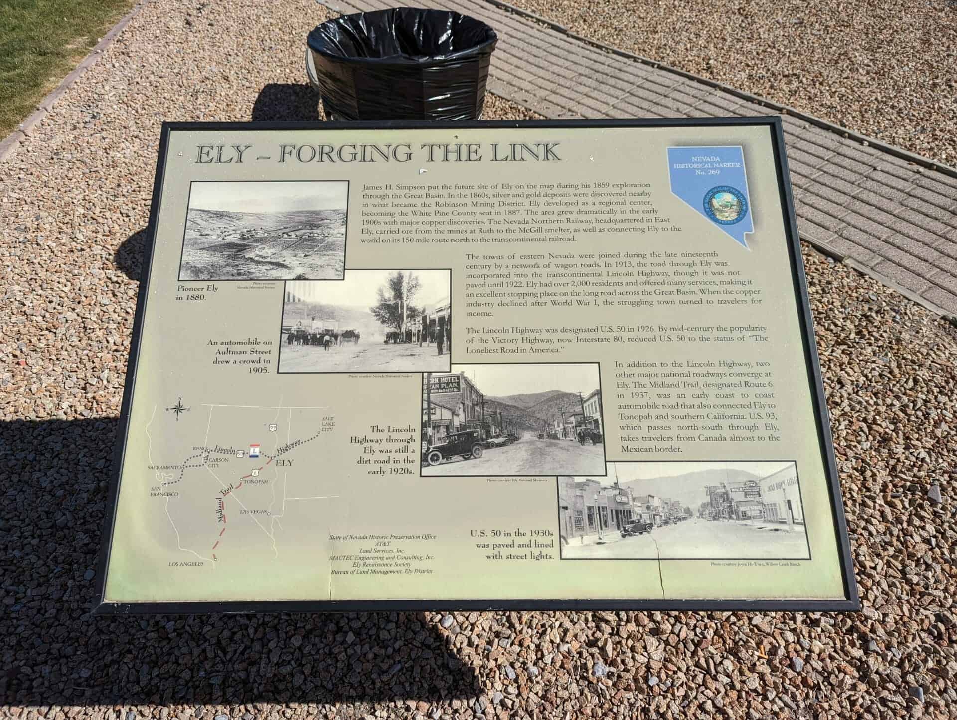
James H. Simpson put the future site of Ely on the map during his 1859 exploration through the Great Basin. In the 1860s, silver and gold deposits were discovered nearby in what became the Robinson Mining District. Ely developed as a regional center, becoming the White Pine County seat in 1887. The area grew dramatically in the early 1890s with major copper discoveries. The Nevada Northern Railway, headquartered in East Ely, carried ore from the mines in Ruth to the McGill smelter, as well as connecting Ely to the world on its 150 mile route north to the transcontinental railroad.
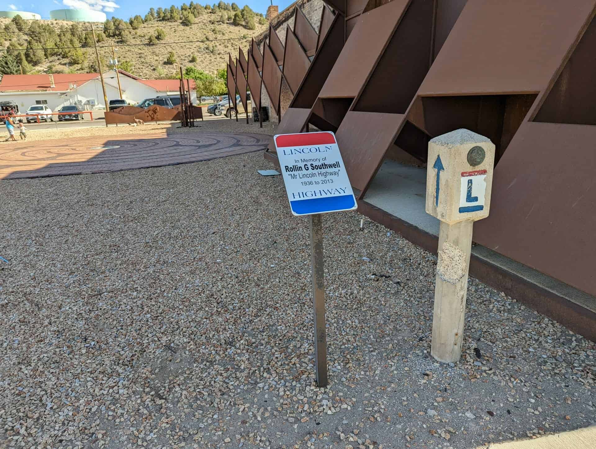
The towns of eastern Nevada were joined during the late nineteenth century by a network of wagon roads. In 1913, the road through Ely was incorporated into the transcontinental Lincoln Highway, though it was not paved until 1922. Ely had over 2,000 residents and offered many services, making it an excellent stopping place on the long road across the Great Basin. When the copper industry declined after World War I, the struggling town turned to travelers for income.
The Lincoln Highway was designated U.S. 50 in 1926. By mid-century the popularity of the Victory Highway, now Interstate 80, reduced U.S. 50 to the status of “The Loneliest Road in America.”
In addition to the Lincoln Highway, two other major national roadways converge at Ely. The Midland trail, designated Route 6 in 1937, was an early coast to coast automobile road that also connected Ely to Tonopah and southern California. U.S 93, which passes north-south through Ely takes travelers from Canada almost to the Mexican border.
This is Nevada State Historical Marker #269, located at 681 East Aultman Street in Ely, Nevada. See others on this page: