This two-story brick commercial building was constructed in 1929. The varied shades of tan bricks are unusual in the historic district. In the early 1930s, the right side of the building was occupied by the “Smart Shop” owned by N. A. Neilson, and the second story housed professional offices. Thorit and Janet Hatch operated the Helper Insurance and Loan Company here for many years.
This valley was originally settled in 1881 by Teancum Pratt. The original Pratt Survey still predominates on maps of this area. He sold land to the Rio Grande Western Railroad for a right of way. By the fall of 1887 the railroad had built 27 frame residences and from this start the town continued to grow. With the completion of the standard gauging of track in 1891, a terminal was established in this area.
It took extra engines to push trains over Soldier Summit, these extra locomotives were called “Helpers” and it was from this source that Helper was named.
With a mixed population of practically every nationality, Helper grew into a booming town. In 1907 Helper Township was incorporated.
This historic marker is located at the old Helper City Hall Building at 73 South Main Street in Helper, Utah and was dedicated by the Matt Warner Chapter 1900 of E Clampus Vitus on July 11, 1987 and remounted and rededicated July 8, 1995.
This one-story red brick flat roof building was built as the Helper City Hall in 1927. This building has classical “tin” cornices, columns and pediment. The project architect was Walter E. Ware of Salt Lake City.
The City Hall has been a center of community events since it was built. The building has always served as Helper’s City Hall, maintains its original appearence and contributes to the historic qualities of the Helper Historic District.
Marker Placed in 1997 by Division of State History. ( CR-07-735.)
Star Dancing Erected June 1, 2010 The Star of Helper represents the sky like the town and has no bounds. The Star also represents Helper as Utah’s Christmas Town. Donated by: Marie Camille Truscott Lentsch (a former Helper resident) Kirt E. Mascaro Helper City Councilman, 2010
Presented to Helper City We pledge allegiange to the flag of the United States of America and to the Republic for which it stands one Nation, Indivisible, with Liberty and Justice for all.
Presented and dedicated by Price Lodge No. 1550, B. P. O. Elks June 14 – 1952
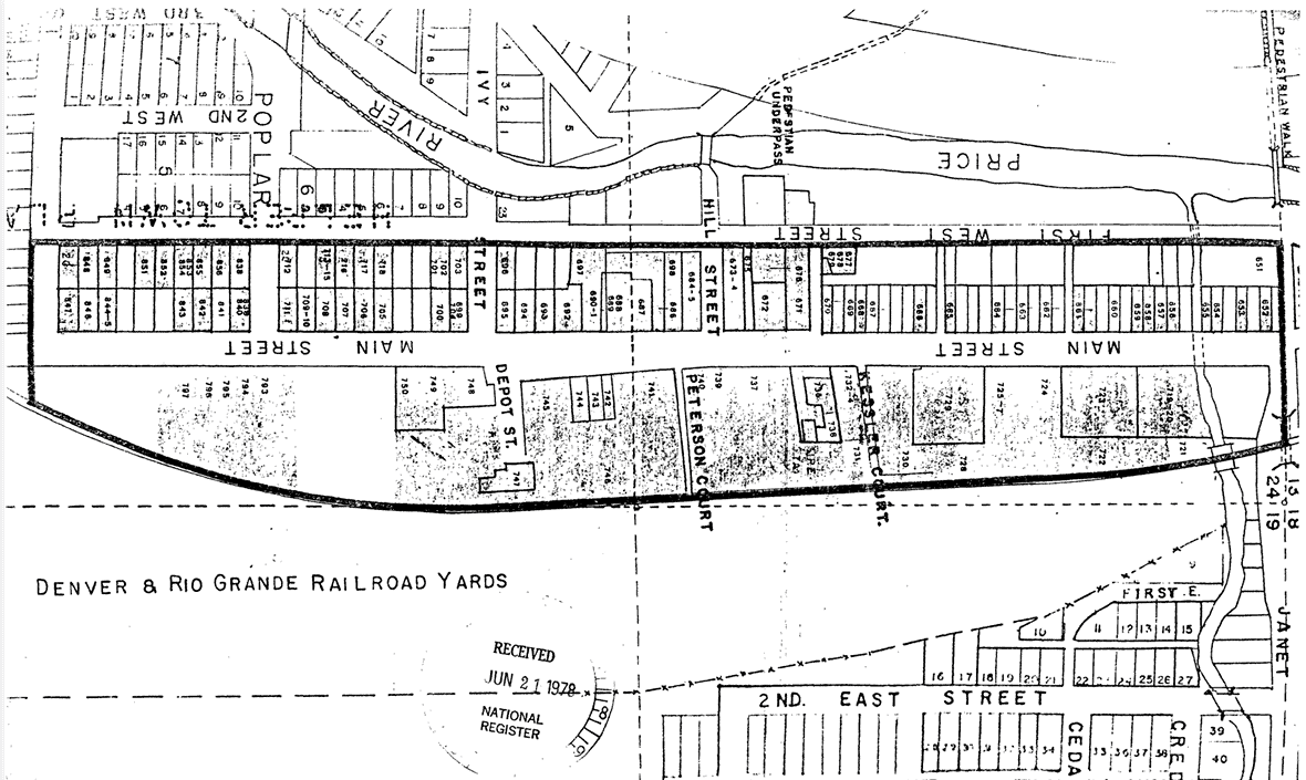
The Helper commercial district is located within the present city limits of Helper, Utah. The District is entirely within the E 1/2 of the NE 1/4 of Section 24, Township 13 South, Range 9E Salt Lake City Standard Meridian. The District is bounded on the north by Janet Street, on the west by First West Street, on the South by Locust Street and on the east by the Denver and Rio Grande Western (D&RGW) railyards. The size of the district is somewhat less than 40 acres and includes, but is not limited to, the entire extent of Pratt’s and Mead’s Survey Platts.
The existing boundaries were selected because of their tight nature, delineating the main Helper commercial district, as well as access points to that area. The inclusion of residences was determined by both their presence on Main Street or their adjacent location to the street and within business district, other residences were excluded and may be part of a future multiple resource nomination.
Janet Street is the northern boundary, and with its underpass (to the east) represents the effective beginning of Helper’s Main Street. On the west is First West Street which contains some residences, but included major rear access ways to the commercial buildings on Main Street. Locust Street boarders the district on the south, representing the end of the main commercial area. The eastern boundary follows the Rio Grande Western railway yards, which formed a vital part of Helper’s commercial life.
The Helper commercial district consists of a total of 110 of which 98 sites have been judged to be potentially contributory to the historic character of the area. A wide variety of both residential and commercial structures, arrayed along both sides of Main street in a north-south manner, comprise the district.
The Helper Commercial District was listed on the National Register of Historic Places (#79002491) on July 24, 1979.
The residential buildings are generally one story and are fairly modest in appearance. Several styles and building materials were utilized, including; hand hewn stone, wood frame, stucco, and several types of brick. The commercial buildings also exhibit a wide degree of variability, although they are generally consistent in scale, with almost all buildings being one to two stories in height. The predominate building material was red brick, although hand hewn stone stucco, wood frame, and other types of brick were also utilized.
Comparison of the present appearance of the district with early Sanborn maps and historic photos indicates that the area still retains much of its historic character. Prior to 1927 the area east of Main Street was dominated by Denver and Rio Grande Western (D&RGW) railroad company houses, but after that time, the area began to acquire the predominately commercial appearance it retains today. The modifications of the residential buildings have been fairly minor and have generally consisted of “modern” siding materials and additions, and modification of the porches. The commercial seen facade modifications, many of which are the installation of the enclosure or buildings have often minor and reversable.
A description of each contributory building along with its capsule history is given below. The buildings are listed by their Utah Historical Society site inventory number.
This one-story vernacular (the common building style of a period or place) house was built in 1903 of hand-hewn stone laid in a random ashlar pattern. The original part of the building is a late example of a hall-parlor house type, which was common in Utah during the second half of the nineteenth century. The house was built by John Bottino and used as a rental property until 1944 when his son, Jim, acquired the property and lived here with his wife, Ida.
Organized and built by the Greek immigrants of Carbon County. Dedicated August 15, 1916 by Reverend Mark E. Petrakis. Built in traditional byzantine style.
The Hellenic Orthodox Church of the Assumption is located at 61 South 200 East in Price, Utah and it was added to the National Register of Historic Places (#73001861) on April 11, 1973.
The following is from the nomination form for the National Register:
The Hellenic Orthodox Church of the Assumption at Price, Utah was dedicated August 15, 1916. The Greek immigrant was the last of the Europeans to come to America and the church at Price was the thirty-third Greek Orthodox Church established in North and South America.
In 1900 there were only three Greeks in Utah, During the Carbon County coal miners’ strike in 1903-1904 Greeks were first brought into the Price area as strike breakers. By 1916 there were 3,000 young Greek men working in the coal mines of Carbon County.
“To the Mormons the Greeks were interlopers among the ‘white’ population; they were clannish, would not marry outsiders, and thought they were an exceptional people with the only true religion on earth…. The Mormons were also clannish, would not marry outsiders, and thought they were an exceptional people with the only true religion on earth,” (Helen Zeese Papanikolgs, Toil and Rage in a New Land, p.143.) The result was a clash of cultures which was intensified by the abuses suffered by the Greeks in the coal mines and camps.
Plans were drawn as early as 1912 for a Greek Orthodox Church, however it was not until August 15, 1916 that construction had been completed and the church was consecrated.
The leaders of the movement to construct a church were Stylian Staes, Emmanuel Salevurakis and Gust Pappas. In 1914 a church had been established in Helper. During 1914 the Greeks from Price met with those of Helper in an effort to convince them that there should be a permanent church building erected in Price, (The church services at Helper were held in a Greek Coffee House.) Eventually the Helper Greeks agreed to aid in the construction of a church in Price.
An attempt was made to secure the donation of a plot of land by Price City, however this was voted down by the Price City Council The land was finally purchased from Lars and Sadie Gunderson for $800.00.
On March 7, 1916 bids were opened for the construction of the church, Lars Gunderson had submitted the lowest bid, $11,336,00, for construction of the church without a heating plant, and the bid of $968,00 for a furnace.
On the day of consecration special trains ran from all the coal camps bringing men to Price for the celebration. They were met at the station by the Sunnyside Italian band which escorted the men to the church. The procession to the church was characterized by shouting and the shooting of guns for good luck to the church.
The church was very important to the Greek population of the county. It gave them a sense of security and stood as a symbol that they had made a permanent settlement. This encouraged the Greek men to send for their wives or, for the majority who were single, to request that Greek girls be sent over for them to marry. In the beginning most of the Greek men had come to America with the idea of earning as much money as possible and then returning to their homeland.
The construction of the church was also significant because it came at a time when foreigners, especially Southern and Eastern Europeans, were regarded as an inferior menace to America. In this respect the church served as a sanctuary for the Greeks from both the intolerance of the American public and the abuses of the coal mines.
The immigrants served by the church were an important element in Utah history sharing in strikes, labor wars, attempted lynchings, Ku Klux Klan attacks, mine explosions and accidents, the Depression and war. In their own way the early Greek immigrants who built the Greek Church of the Assumption were just as much pioneers as were the Mormons who came to Utah more than fifty years earlier.
The original church was of traditional Byzantine construction in which the dome rests on a square supported by four pillars with the nave of the church in the form of a cross. It was built of yellow colored brick with a foundation of cement.
In 1940-41 a new entrance, two towers on the outside front, and an inside balcony were added. The original wooden columns were replaced by four cast Corinthian columns.
A fire in 1945 caused considerable smoke and water damage. The altar and environs were badly marred. A new tableau was built and the Rev. Zoygraphos of Texas, a Greek priest and iconographer, was commissioned to paint new icons for the entire church to replace the original ones ruined by the fire.
The icons, religious images painted on panels, have been called the “Bible of the Unlettered.” They cover the iconostasion or altar screen. The central large figure on the middle door of the altar m screen, the Royal Gate, which slides open to reveal the altar, is of Christ the Arch Priest, while other icons always include Christ on the right, Virgin and Child on the left, etc. The second and third rows above show scenes from the life of Christ and the twelve Apostles respectively. There are icons on the two sides of the church, while the four pendentives depict the Evangelists: Matthew, Mark, Luke and John, The most awe-inspiring scene of all fills the concavity of the top of the dome and is a symbolic representation of God the Father, surrounded by an angelic host, holding the world in His left hand. The vertical walls of the dome are covered by portraits of Old Testament prophets and contain numerous round, stained and leaded glass windows; they cast a subdued, even light on the contents of the dome.
Another artifact of singular beauty is the massive brass and crystal chandelier which hangs by a huge iron chain from the center of the dome. It was a feature of the original church and the sum of $560 was raised for it by the Greek miners of Hiawatha, a coal mining camp of southwestern Carbon County. It was also extensively damaged by the fire, but was repaired and restored at a cost close to its original value.
In 1961 the church was again enlarged, however the basic integrity of the church has been maintained in spite of two remodelings and one fire-induced renovation. In fact, these programs have added to and enhanced the structure while producing much-needed space. On each side of the church are three of the original stained and leaded glass windows. Another is in the east end of the church behind the altar. A dozen of the original small, round, stained and leaded windows augment the sides of the dome. The size of the building as it now stands is 87 feet 8 inches long by 43 feet six inches wide.
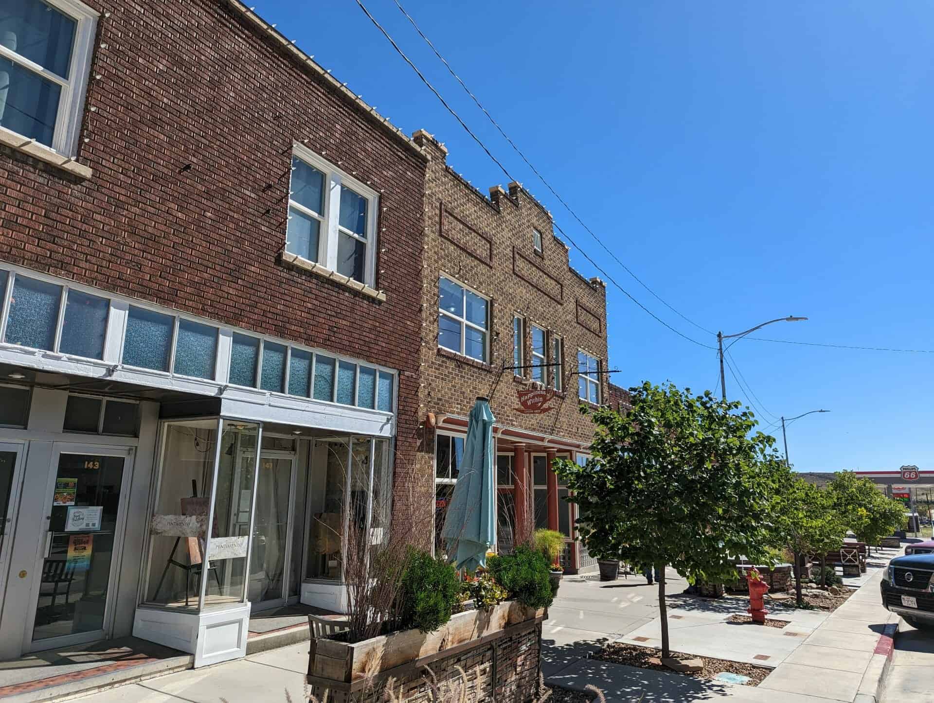
This one-story red brick commercial block was built by Helper Securities in 1927 and contained seven businesses. The northern section originally housed the J.C. Penney store managed by M. P. Street. Just south, the Safeway store was operated during the early 1930s. South of Safeway was Central Cleaners, first owned by E. E. Iwanoto during c.1933-70. The southern portion of the building was occupied by a drugstore during the early 1930s. A similar Helper Securities building containing five businesses was also built in 1927 on the south end of this block.
This single-story, red brick, commercial one-part block building was originally owned by John Milon, George Gigoumakis, and Steve Zoulakis. The building was at one time an O.P. Skaggs meat and grocery store operated by Barney Hyde. Mr. Hyde was also active in the community as the president of the Chamber of Commerce, president of the Kiwanis Club, a city councilman, and mayor of Helper in the 1940s. A clothing store later occupied the building for many years.
One story red brick commercial building, originally owned by John Milon, George Gigoumakis and Steve Zoulakis. This building was previously an O.P. Skaggs meat and grocery store operated by Barney Hyde, who was also mayor of Helper 1940-1943. A clothing store now occupies the building and there have been minor façade modifications.
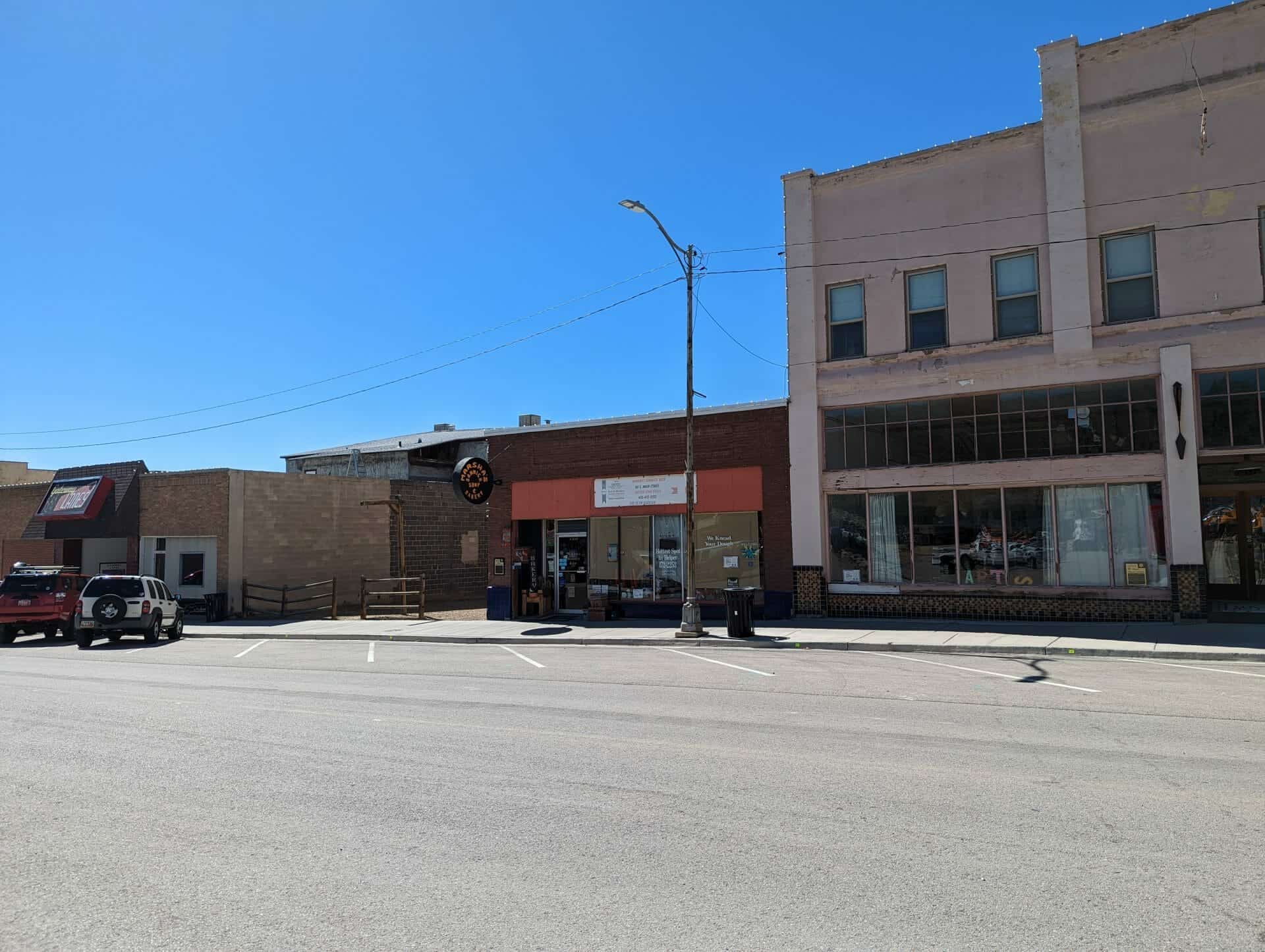
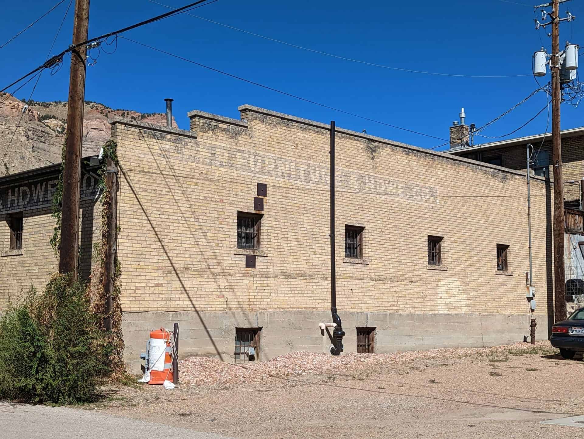
This building was constructed in 1919 out of brick and stone rubble salvaged from the burned Double Rock store. Helper Furniture and Hardware Company, a business started by Mike Bergera and purchased by Joe and John Quilico in 1923, was located on the first floor. The original J. C. Penney store in Helper was also located on the first floor. The Hotel Utah, operated in the 1930s by D. C. Cavenah, was located on the second floor. This two-story commercial building contributes to the historic character of the Helper National Register Historic District.
Two story red brick stone and stucco commercial building. Present building was originally owned by Mike P. Bergera and was constructed from the brick and stone rubble of the Double Rock store building which burned in May 1919. The Helper Furniture and Hardware Company was located in the first floor. Begun by Mike Bergera, the furniture business was purchased by Joe and John Quilico in 1923. The original J.C. Penney business was located in the LHS of the first floor. The second floor was the Hotel Utah (presently called the Utah Hotel), operated in 1935 by D.C. Cavenah. The first floor decorative tile dates Business offices presently occupy front façade has been altered. from the early 30’s. Business offices presently occupy the first floor, and the front façade has been altered.
Behind the building is this one story hip roof, tan brick warehouse building constructed for Helper Furniture and Hardware Co., listed as CR-07-676 in the Helper Commercial District.
After sitting 161 years on its original building site, the Joseph “Cap” Hill cabin was moved to Layton Commons Park in 2017. This cabin is one of the oldest pioneer buildings in Davis County. It was built by Joseph Hill Sr. and his family between 1851 and 1854 and has been in the possession of the Hill family for over five generations.
Joseph “Cap” and Edith Ann Hill
Born in Gloucestershire, England, Joseph and his wife Edith Ann Marsden Hill, joined The Church of Jesus Christ of Latter-day Saints and immigrated to America in the 1840s with their three children – John C., Joseph Jr. and Alice Ann. They lived in Nauvoo, Illinois for a time and then moved to Utah Territory in September 1850. After arriving in Salt Lake City, the Hill’s move to the Kay’s Ward (later Kaysville) settlement to establish a permanent home. During this exodus across the plains, Joseph served as a captain of 10 wagons, under the direction of Mathew Caldwell, a captain of 50. For the rest of his life, Joseph would be remembered as “Cap” or “Captain” by his many friends and neighbors.
Joseph Sr. and his family worked hard to build a new homestead in what is now West Layton, on the west side of Angel Street. Once the cabin was built, the family established a farm where they raised hay, grain crops and cattle. In the late 1850s, Joseph Sr., hoping to seek his fortune in the gold fields, moved his family briefly to Sacramento, California; however, they returned to Utah in 1862. While passing through Carson City, Nevada, Edith Ann was critically injured in a wagon accident and died on July 4, 1862. After burying his wife, Joseph Sr. returned to Kay’s Ward and took up residence once again in the cabin he had built. He lived there until his death on august 21, 1889; and he was buried in the Kaysville City Cemetery. Following his death, the cabin was used for a variety of purposes until it fell into disrepair.
Eventually, the cabin passed into the possession of Joseph Sr.’s 2nd great-granddaughter, Odessa Webster Hill Harris and her husband Robert Jay Harris. The couple restored the cabin to its current condition in 1990. In 2000, the Harris’ built a beautiful home on the Hill property next to the cabin and cared and looked after the property until their passing in 2017. After their deaths, the cabin was moved to its current location where it serves as a reminder to Layton citizens as well as to all visitors who see it of those who came before us.
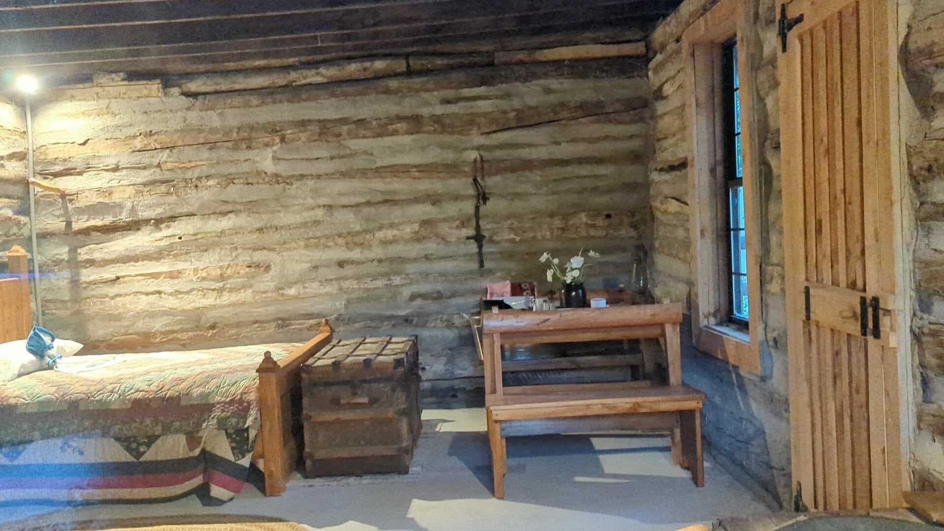
The Joseph Hill Family Cabin, built sometime between 1851 and 1858, is a one-story single-pen log cabin, located at 2133 W. 1000 South in Layton, Davis County, Utah. After a period of vacancy and deterioration, the cabin was rehabilitated around 1990 when it was raised and placed on a concrete pad. The rehabilitation included replacement logs from a derelict barn on site, re-chinking, replacement windows and interior casings, gable trim, an interior brick chimney, drop ceiling, and a new roof with wood shingles. Despite these modifications in some materials and workmanship, the Hill Family Cabin retains its historic integrity in terms of location, design, feeling and association of a pioneer-era log cabin. Although the immediate setting of the cabin has been compromised by the landscaped yard, the wider setting is still rural as much of the original farmstead remains agricultural. A new home built on the 1.53-acre property in 2000 is non-contributing. There is also an associated historic outhouse near the log cabin, but the outhouse has been modified and moved, and is therefore considered non-contributing. The Joseph Hill Family Cabin is one of four extant log cabins in the Layton area and the only example that still retains its domestic appearance. The cabin is a contributing resource in its Layton neighborhood.
The Joseph Hill Family Cabin sits on roughly rectangular property of 1.53-acres, a combination of two descriptions into one legal parcel. The cabin is located at the southeast corner of the property in the backyard of the non-contributing house, built in 2000, facing north to 1000 South. The new house was built where a one-story red brick Victorian-era cottage was located before it was destroyed by fire in the 1970s. The property is mostly lawn with pasture on the three adjoining sides. There is one mature elm tree located north of the cabin. This tree is the only remnant of the copse that surrounded the cabin prior to the rehabilitation. There are newer trees with decorative boulder plantings scattered in the backyard. A non-contributing gazebo structure is in one of the plantings. Just south of the cabin in one of the plantings is a wood outhouse. Although historic and associated with the cabin, the outhouse was recently moved and does not retain sufficient integrity to be contributing. There is also new gazebo west of the cabin.
The West Layton neighborhood at the intersection of 2200 West and 1000 South retains a rural feeling despite recent construction activity in the area. There are newer homes on either side of the cabin property, but there is pasture between. A new barn sits southwest of the log cabin on a separate legal parcel. There are onion fields to the north of 1000 South. To the south is undeveloped open pasture, further south and west are marshes at the edge of the Great Salt Lake. The path of the abandoned Bluff Road is visible in aerial photographs in the vicinity of the Joseph Hill Family Cabin.
The Joseph Hill Family Cabin in Layton, Utah, is locally significant under Criterion A, in three distinct areas: Exploration/Settlement, Commerce, Transportation, and Ethnic Heritage. The log cabin built by the Hill family is a rare extant example from the early settlement of the area formerly known as West Layton. The exact date of construction is unknown. In local histories, the construction of the cabin has been attributed to either Joseph Hill Sr. upon his arrival in 1851 or his son, Joseph Hill Jr., prior to his marriage in 1858. Both families are considered important early settlers of the Big Field area of West Layton. The Hill cabin was never moved from the family farmstead along the Bluff Road contributing to the cabin’s significance in the areas of Commerce and Transportation. Bluff Road was the preferred route for California-bound gold seekers leaving Salt Lake City to travel around the north end of the Great Salt Lake. The Hill family raised cattle on the flats below the bluff and sold beef and other commodities to the travelers. The family also represents the small minority of Mormon settlers who were lured to California by the promise of gold and silver. Joseph Hill Sr.’s extended family left Layton in 1860 and returned in 1862 after an unsuccessful and tragic journey, which resulted in the death of his wife, Ann Edith Marston Hill. After their return, Joseph Hill Jr. built a red brick house for his wife, Ellen Sheen Hill, and family. During that time Joseph Sr. may have lived in the cabin behind the brick house. The Hill Cabin is the only extant log cabin in Utah that is linked to the Bluff Road and it is the only known cabin in Layton to have continued a residential use into the twentieth century.
The Hill Cabin is also the only documented building in Davis County to be associated with the Japanese soaking tub practice (known as ofuro), which gives the building significance in the area of Ethnic Heritage. The continued maintenance of the log cabin as a residence likely contributed to its easy conversion to a bathhouse/dressing room in the 1940s and 1950s for one of the many Japanese families that rented farms in West Layton. Beginning in the 1920s and continuing into the 1950s, several Japanese families moved to Davis County to become farmers. Because the immigrants were discouraged from owning land, the immigrants share-cropped or rented the farms of older residents. Despite modifications that occurred during a circa 1990 rehabilitation, the building retains many of the characteristics that it had during an exceptional long period of significance that represents a century of productive use. The Joseph Hill Family Cabin is a contributing resource in its West Layton neighborhood.
The history of Layton begins with the history of Kaysville, Utah. In the winter of 1847-1848, just a few months after the arrival of members of the Church of Jesus Christ of Latter-day Saints (LDS or Mormon Church) to the Salt Lake Valley, Hector C. Haight kept a herd of cattle in the area, and in April 1850, William Kay and Edward Phillips raised wheat near what became known as Kay’s Creek. They were later joined by several families. By 1853, the population of Kaysville, which included present-day Layton, was 417. Among the settlers who came in 1850 was the family of Joseph and Ann Hill. Joseph Hill Sr. was born in 1806 in Sandhurst, Gloucester, England. His wife, Ann Edith Marston, was born in 1808 in Norton, Gloucester, England.34 They were married in 1828 and had three children, John Calvert (born 1835), Joseph Jr. (1837) and Alice Ann Marston (1839). The family immigrated to the United States before 1850. Joseph Hill Sr. was designated a captain over a team of immigrants while crossing the plains and was known as Captain or “Cap” Hill for the rest of his life. The family was living in a log cabin on “the salt flats near or on the dividing line between Kaysville and Layton” by time of the 1850 census enumeration. This area was known as the “Big Field.” A hand-drawn map of the early settlement places the Joseph Hill Sr. home north of Kay’s Creek in the northwest quarter of Section 31, Township 4 North, Range 1 West.
Unlike many of his contemporaries, Joseph Hill Sr. did not file for a homestead patent for his land. The first recorded claim to the land was when his son, Joseph Hill Jr., obtained a deed for 159 acres in the west half of Section 31 from the Union Pacific Railroad Company in July 1880. While the exact location of the first home of Joseph Sr. and Ann Hill is unknown, historic records agree that by the time of his marriage, Joseph Hill Jr. lived in a log cabin at the present-day intersection of 1000 South and 2200 West, although neither street existed prior to the 1880s. Joseph Hill Jr. married Ellen Sheen on December 28, 1858. Ellen Sheen Hill was born in 1837 in Berrow, England. She came to Utah in a handcart company in 1856 and settled in west Kaysville with her family. Joseph Jr. and Ellen Hill had two sons and five daughters. They lived in the log cabin until they were able to build a red brick house that faced north to a lane along the north line of Section 31 (today’s 1000 South). The 1870 and 1880 census enumerations show that after Ann Hill’s death in 1862, Joseph Sr. lived next to Joseph Jr. and Ellen. The juxtaposition combined with the Victorian-style windows added to the cabin suggest that Joseph Sr. may have lived in the log cabin on the property until his death in 1889.
By the 1880s, residents of the Layton area wanted to separate from Kaysville, which had been in incorporated in 1868. They questioned Kaysville’s authority to tax their property without providing municipal services. The Layton Ward of the LDS Church, named for early settler Christopher Layton, was established in 1889. The West Layton Ward of the LDS Church was organized in 1895, one year after a court case was decided in favor of the residents. Layton became an independent unincorporated area in 1902 and an incorporated town in 1920. By the time of incorporation, roads along the section lines (e.g. 2200 West) were created to connect to Gentile Street, the main east-west road to the Layton’s growing commercial district and the railroads.
Only a tiny fraction of the thousands of log cabins built by Mormon pioneers exist today. Of the twenty-seven log cabins built before the coming of the railroad that appear in the Utah SHPO’s database of historic resources, seventeen have been moved to museums or city parks for display. For example, the circa 1865 Levi Roberts cabin originally built on Kay’s Creek was moved to This is the Place State Park on the east bench of Salt Lake City in 1977. The Layton area is current represented by only four extant log cabins: the Hill cabin, the Higgs cabin on Fort Lane in East Layton, the Webster cabin on Angel Street (moved 500 feet), and the Kay cabin (moved to Syracuse). More importantly the Hill Cabin is the only surviving cabin that sits on its original farmstead and was associated with the emigrant trail along Bluff Road.
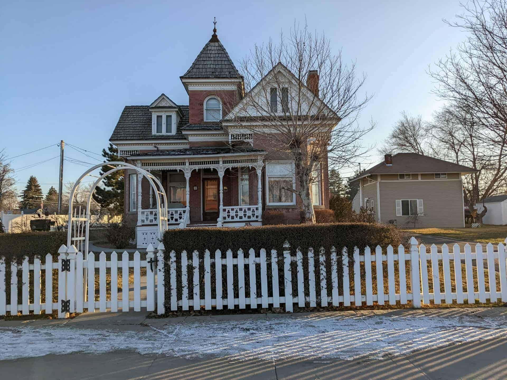
The Alex and Mary Alice Johnson House is located at the corner of Main Street and Hale Street in Grantsville. It is a one-and-one-half story brick home in the Queen Anne style built in 1900. The plan of the main floor gives the impression of a cross-wing house with a square tower at the intersection of the wings. However, more substantial than a typical cross-wing, it may also be considered a modified central-block with projecting bays. The house is on a one-half acre property with three outbuildings that retain their historic integrity but do not contribute to the historic significance of the house.
The house sits on a coursed rubble foundation. The masonry consists of two types of brick. It is faced with a fired red brick and lined with adobe. The courses are laid in a running bond with 4″ projections at the corners of the octagonal bays. The lintels, sills, and water table are of sandstone. The main floor fenestration is a combination of large fixed sash windows with transoms and smaller double-hung windows. There are paired double-hung windows in each of the four gable ends and the two small dormers. The tower has round arched windows, brick voussoirs, and decorative brick-work at the imposts. The tower’s pyramidal roof is capped with a metal finial.
Probably the most striking part of the house is the decorative woodwork, which according to one source, has always been painted white. 1 The gable trim includes octagonal shingling with lozenge patternwork in the peak. Engaged pilasters with bracket “capitals” flank the windows. Similar details occur on the dormers. Dentils are found on the main cornice completely surrounding the house, as well as on the tower cornice. Corner brackets with lathe-turned spools and spindles occur at either side of the bays. The north and east porches are particularly elaborate. Each consists of lathe-turned columns and console brackets which support a spool and spindle frieze. Other decorative elements on the porches include dentils, fan-shaped brackets, pendants, and paterae. Scroll-cut woodwork is found on the balustrades and the base enclosure.
The principle elevations of the building have remained virtually unaltered since its construction. Minor alterations have been made to the rear, or south elevation, and concrete steps have been added to the east porch. A porch which spanned the length of the rear elevation was enclosed probably within a decade of the original construction. The east half of the porch was screened and the west half was fully enclosed to form a room. A doorway was cut from the main house to this room. In the 1950s, both the room and the screened porch were removed. They were replaced by a concrete porch supported by simple metal columns. Two other changes occurred in 1993: the cellar stair enclosure on the west elevation was repaired and the mid-century asphalt roof was replaced with wood shingles.
( This was added to the National Register of Historic Places (#95001433) on December 13, 1995 and is located at 5 West Main Street in Grantsville, Utah )
The interior of the house consists of several large well-lighted rooms with eleven-foot high ceilings. A small entrance foyer is at the base of the tower and contains separate doors to the dining room and parlor. The two rooms are also connected by a set of double doors. A large kitchen runs the east length of the house, with an enclosed staircase parallel to it. A second set of cellar stairs is found under the main staircase. The west side is separated into two smaller rooms: one was probably used as a bedroom, while the other was the family bathroom (the house was reportedly one of the first to have indoor plumbing in Grantsville). On the second floor there are four bedrooms, a nursery and a small office in the tower. The attic can be accessed from a trap door near the stairs.
Except for some changes in wallpaper and paint, the interior is in good historic condition. Some woodwork has been painted, however, most of the panelled doors, window casings, and other woodwork are stained and varnished. With one exception, both interior and exterior doors have working hopper transoms and all original hardware. Decorative elements at the doors and windows include corner blocks and paterae. Most of the glass appears to be original.
The house has a full fireplace in the parlor and stove-pipe flues in the kitchen and main floor bedroom. The parlor boasts a tall mirrored mantel with Ionic columns and a carved festoon/wreath. The interior is remarkably well-preserved. In the 1950s the kitchen was partitioned to create a laundry room and new appliances were added. There was also some work done to the kitchen in the 1970s. However, the original wainscotting is still visible on two sides of the room and only the lattice at the top of the partition seems out of period. The bathroom also contains fixtures from the 1950s remodel and includes the blocked door to the missing back room. Other than paint, wallpaper and new flooring, the second floor has seen little modification since a second bathroom was added in the 1950s. The house is still heated by its original boiler and radiators.
The site has three outbuildings which were used by the original household. The small pumphouse at the rear most likely dates to the original construction and supplied water to the house. A small chicken pen has been added to the pumphouse. In the southwest corner of the property sits a large framed three-car garage, built sometime after 1910. The garage also includes a room originally used as an icehouse. A two-story frame summerhouse sits west of the house, and was probably built after the garage (around 1915-1920). The main floor of this building served as a laundry and the upper floor was used for bedrooms. This building has been partially covered with aluminum siding and is currently rented as a residence. An L-shaped asphalt driveway covers a large portion of the property, but the remainder consists of trees, lawns, and flower beds. A rock garden and fountain have been built near the east porch. Sidewalks run from the perimeter to the north and east porches. The property has a combination of picket, post, and chain-link fences.
The Alex and Mary Alice Johnson House, built in 1900, is an excellent example of the Victorian Queen Anne style. This style of architecture documents an important period of growth in Utah. The design, though executed by a local builder influenced by pattern-books, combines a remarkable unity of composition with elaborate decoration. With its prominent position on Main Street, the Johnson House is one of the most distinctive architectural landmarks of Grantsville. Both the exterior and interior details of the home have been extraordinarily well-preserved. The house meets National Register Criterion C in the area of Architecture as the most outstanding example of a Queen Anne house in the community.
Alexander Johnson began construction on the home in 1899, just after his marriage to Mary Alice Anderson. Both were natives of Grantsville, born in 1870 and 1878 respectively. His parents were Charles Johnson and Charlotte Erickson, Swedish immigrants to Grantsville in 1863. Her parents were John Anderson and Mary Ann Clark. Alex and May built their house on the property was just south and across Main Street from the Deseret Mercantile (Johnson Hall) built in 1898, where Alex was engaged in the family business with his father and brothers. During his lifetime Alex also raised sheep, cattle, and horses. A successful businessman, he served as the director of the Grantsville Deseret Bank. He and his wife Alice were both members of the Church of Jesus Christ of Latter-day Saints (Mormon) and served the community in both church and civic positions.
The builder of the Johnson House was Charles Zephaniah Shaffer. He was born in Pennsylvania in 1842, listed as a carpenter in the 1900 business gazetteer, and died in 1904. Shaffer also constructed a Queen Anne home at 5 North Center Street. It is not known whether he was responsible for other Queen Anne homes in the Grantsville area. 2 The Johnson house contains all the characteristics of the style: an asymmetrical plan and façade, a variety of materials and textures, decorative shingling and brick, elaborate woodwork, and a tower.
Great care was taken in the construction of the house. According to Mildred J. Conway, a daughter of Alex and Mary Alice, each red brick, imported from California, came individually wrapped in paper. When completed in 1900 at a cost of $4,500, the home was one of the most elegant and modern (with its indoor plumbing) in the community. The ornate mantelpiece cost $75.
Alex and Mary Alice Johnson raised ten children in the home. In addition, they also took in Alex’s three nephews and a niece, who had been orphaned. The already spacious home was augmented by the building of the summerhouse, c.1920. The three-car garage was reportedly built for the four Model-T Fords the Johnsons acquired to transport their large family. Alex’s mother also lived with them and a room was built on the back porch for her. The home was literally at the center of community life in Grantsville. From his office at home in the second floor tower, Alex could view his mercantile business just across the street, known as Johnson Hall, and also used as at various times as the town’s bank, post office, and dance hall.
During the depression, with most of their children grown, Alex and Mary Alice took in boarders. Throughout the thirties and forties, the house was called the Lone Pine Tourist Home after the large pine tree in the front yard. Its distinctive architecture, its proximity to the Lincoln Highway, and a scarcity of housing near the Tooele Army Depot insured the lodge never lacked tenants.
Alex died in 1943 and Mary Alice in 1952. The Johnson’s daughter, Mildred J. Conway, moved into the house after her mother died. The few alterations which have made to the house were done while Mildred was the owner. She lived in the house until 1989 and died in 1991. In November of 1989, the house was sold to Grantsville natives, Gary and Janet Fawson. The Fawsons only lived in the house one month before moving to California. It was then used as a rental property. It was sold to Francis and Betty Menalis in October 1992. Betty had seen the house several years earlier and was determined to purchase it if ever it became available. She and her husband are committed to preserving and restoring the original appearance of the house, including re-roofing the house in 1993 with wood shingles. Betty has also been able to purchase some of the original furnishings and return them to the house.
Despite its use as a boarding house and a rental property, the Alex and Mary Alice Johnson house is in excellent condition and retains its historic integrity. This is due in part to its remaining in the same family for eighty-nine years, as well as the appreciation of subsequent owners of the artistic value of the architecture.
The Victorian Queen Anne style is reflective of changes that occurred in Utah near the turn of the century. The architecture in Utah was founded in American building traditions and the early builders had been, for the most part, isolated from the secular influences of much of the country and used established methods brought with them from their homes of origin. As Utah grew and became more integrated with non-Mormons, the architectural styles that were made popular through pattern books were readily available to Utah builders. The building boom of the 1880s and 1890s corresponded with the growth of the non-Mormon population in Utah and brought with it the opportunity to bring in new building traditions such as those published in the style books, popular in Utah during the late nineteenth and early twentieth centuries. With the introduction of plan books, “the former isolation of rural areas was no longer an obstacle to building due to the widespread dissemination of information and building materials.” Plan book Victorian stylistic features were based upon the use of multiple forms and elements and were probably influential in building the uniquely stylized, eclectic, Alex and Mary Johnson residence. The Queen Anne style is one of the most picturesque of the late-nineteenth-century styles and became the most popular style of the period in America. It was popular in Utah between 1885-1905.