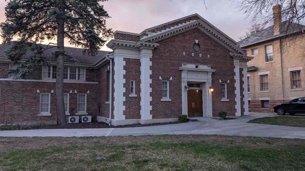
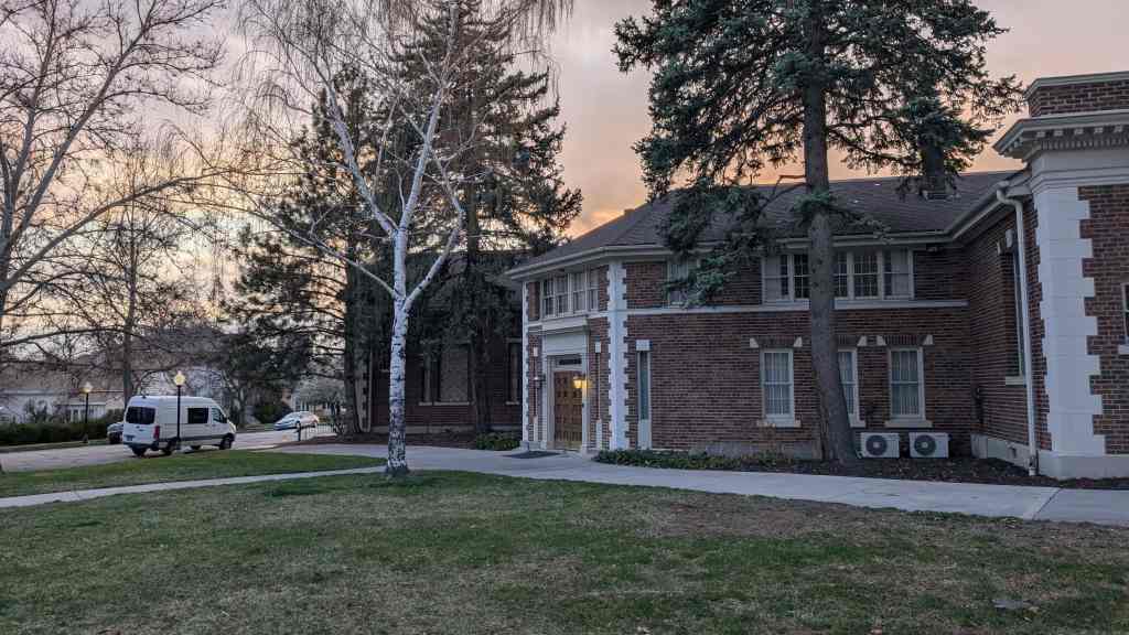
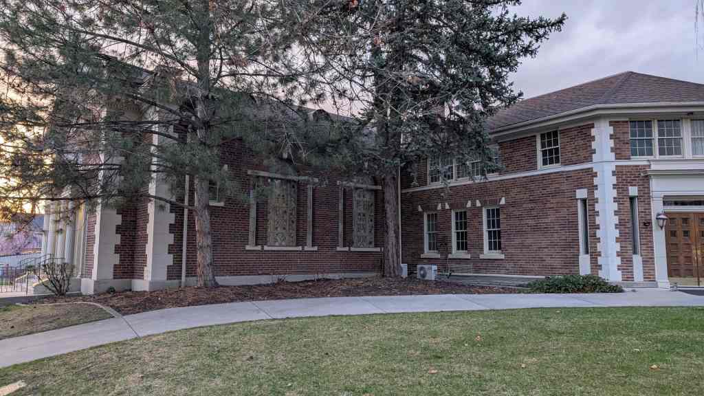
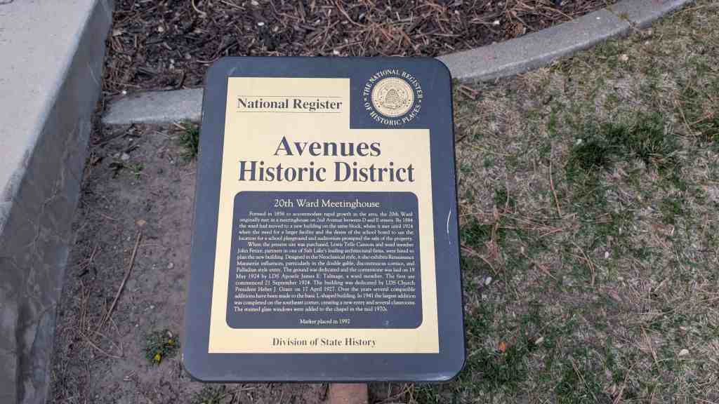
Formed in 1856 to accommodate rapid growth in the area, the 20th Ward originally met in a meetinghouse on 2nd Avenue between D and E streets. By 1884 the ward had moved to a new building on the same block, where it met until 1924 when the need for a larger facility and the desire of the school board to use the location for a school playground and auditorium prompted the sale of the property.
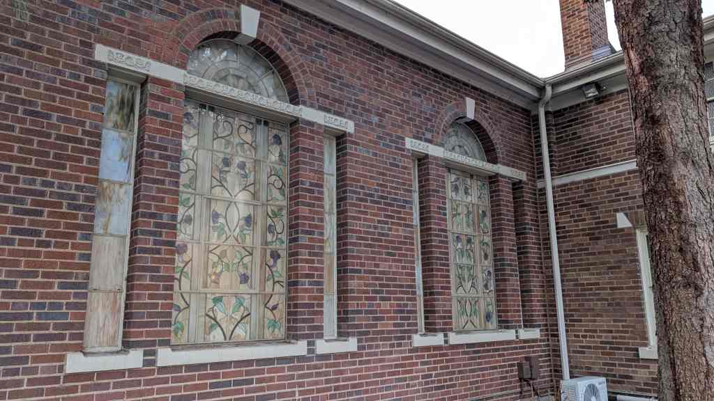
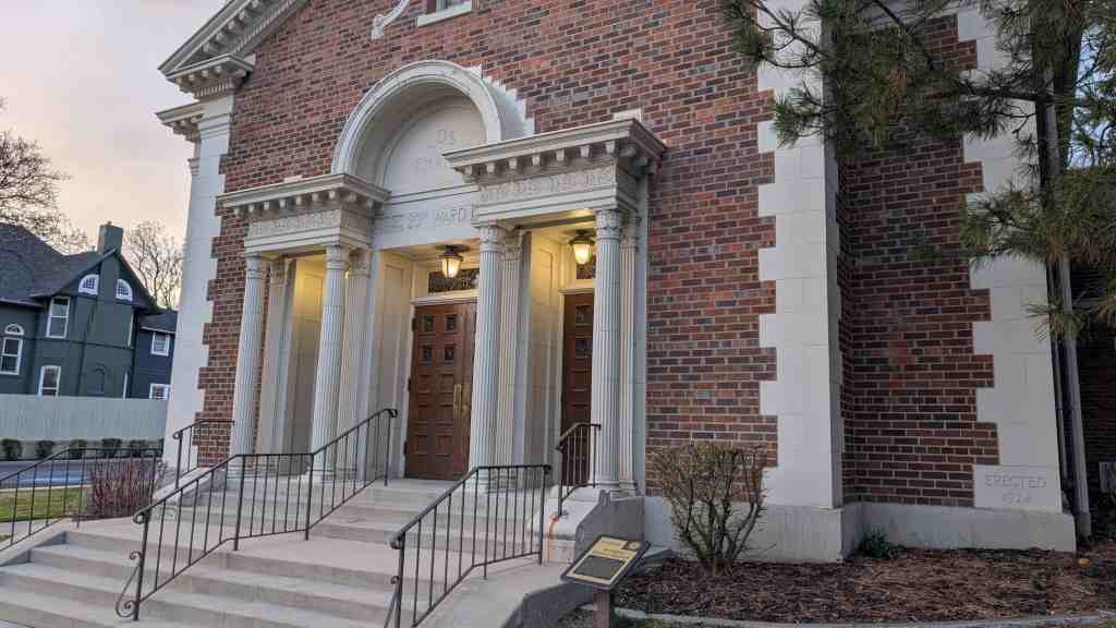
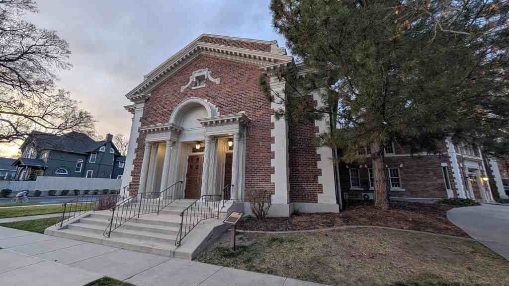
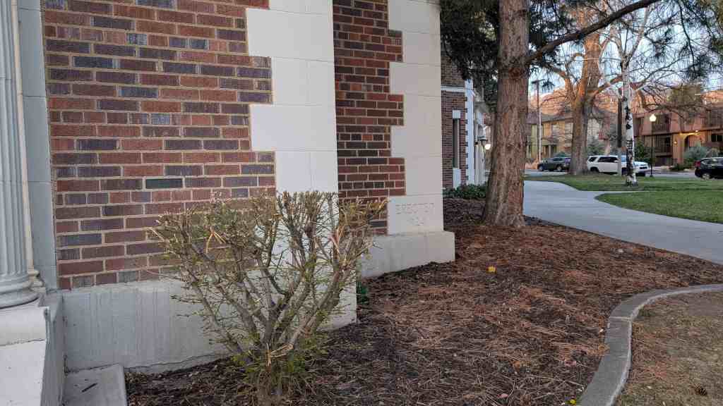
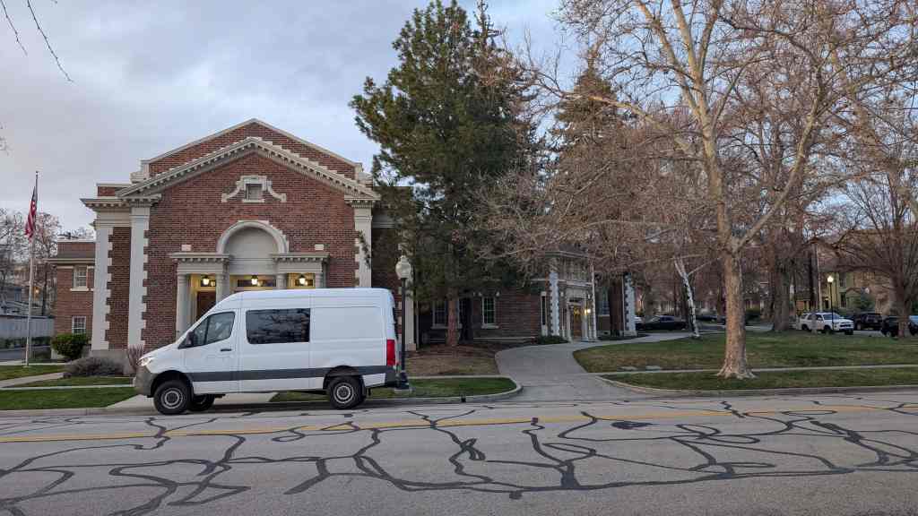
When the present site was purchased, Lewis Telle Cannon and ward member John Fetzer, partners in one of Salt Lake’s leading architectural firms, were hired to plan the new building. Designed in the Neoclassical style, it also exhibits Renaissance Mannerist influences, particularly in the double gable, discontinuous cornice, and Palladian style entry. The ground was dedicated and the cornerstone was laid on 18 May 1924 by LDS Apostle James E. Talmage, a ward member. The first use commenced 21 September 1924. The building was dedicated by LDS Church President Heber J. Grant on 17 April 1927. Over the years several compatible additions have been made to the basic L-shaped building. In 1941 the largest addition was completed on the southeast corner, creating a new entry and several classrooms. The stained glass windows were added to the chapel in the mid 1970s.
Preservation Utah‘s “Kletting in the Avenues” Historic Homes Tour said: The design of the Twentieth Ward Meetinghouse reflects a significant shift in how the LDS Church built its meetinghouses. During the 19th century, church buildings were designed and built almost entirely by individual wards with each function (chapel, recreation hall, Relief Society building, bishop’s storehouse, tithing office, et al) occupying its own building. But by the 1920s, when this building was constructed, the design of meetinghouses was becoming increasingly standardized, primarily to consolidate those various functions. Although its general layout may have been standardized, the design of the Twentieth Ward Meetinghouse showcases the high level of design available in the early 20th century to middle class wards with extra funds. The meetinghouse was designed by the firm of Cannon and Fetzer, which designed other notable buildings in Salt Lake, including the Park Building at the University of Utah and West High School.
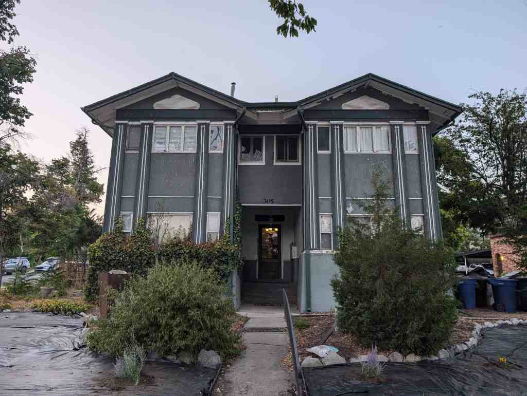
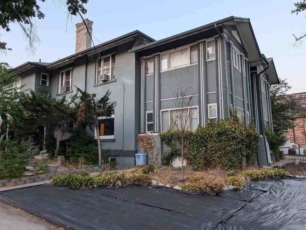
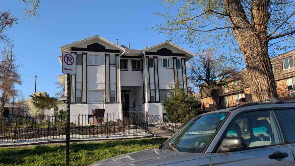
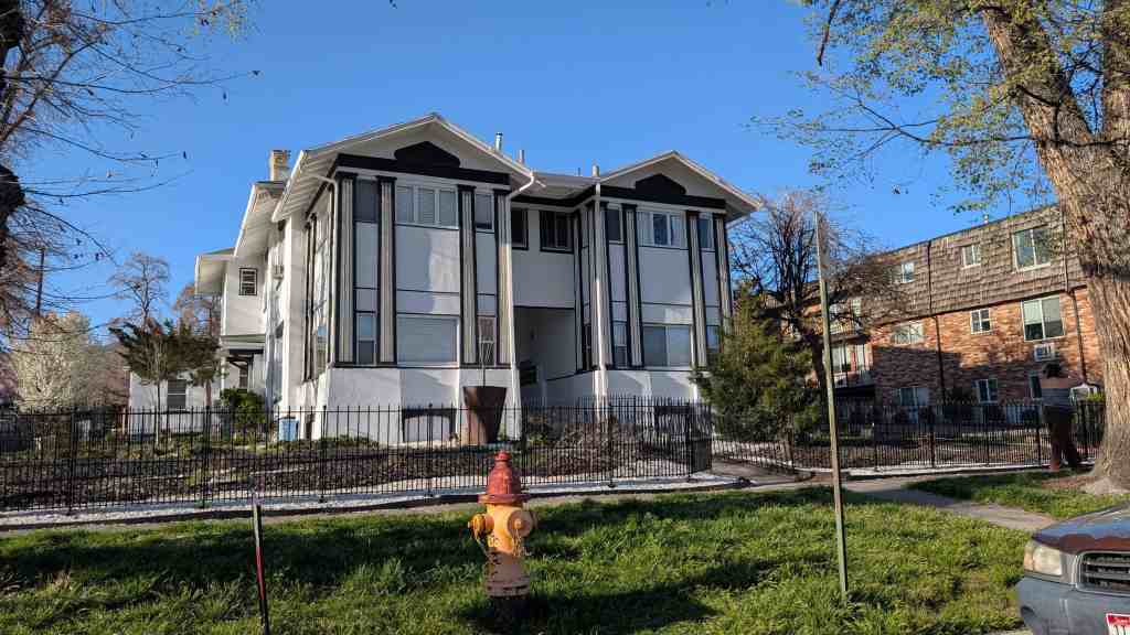
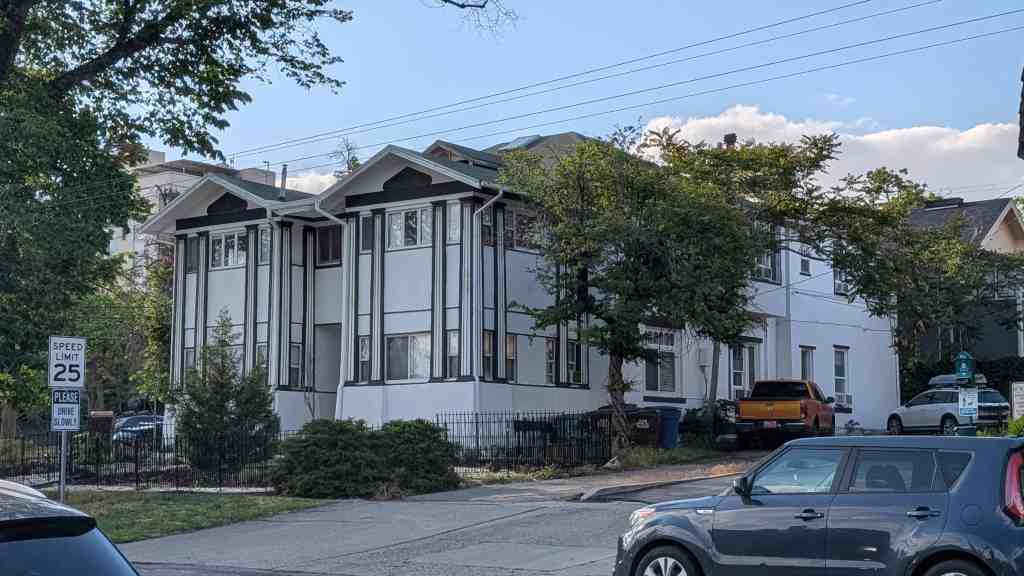
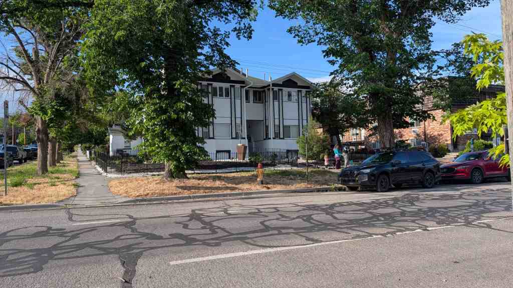
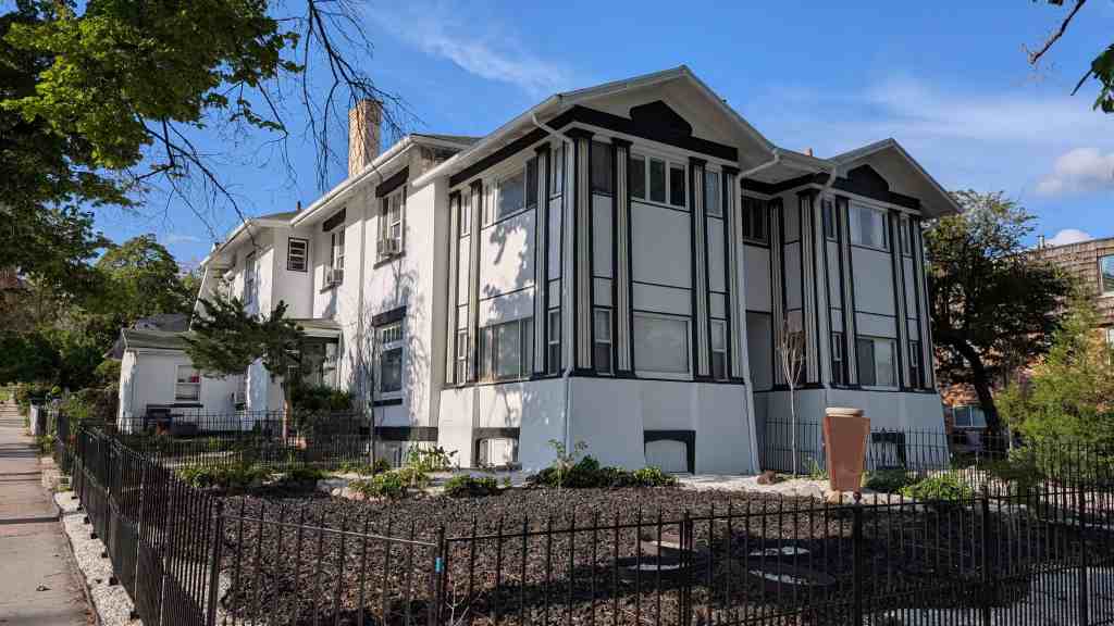
Large two story stucco structure with a two-story double gabled wing with unusual tapered pilasters.
Some of this structure may be part of the adobe and frame dwelling built about 1873 by Levi Richards, although no nineteenth century elements are visible.
Levi Richards (1799-1877) came to Utah in 1853. He had studied medicine and served on the Utah “Board of Examination” for physicians. Richards only son, Levi W. ( -1914) inherited this property upon the former’s death and lived here until his own death.
Levi W. was a real estate and business entrepreneur. In keeping with the religion, of which he was an active practitioner, Richards had more than one wife. He married Louise Lula Greene in 1873 and her niece Persis Louiza Young in 1884. The women remained close “sister” wives until their deaths, living together in this house and other dwellings.
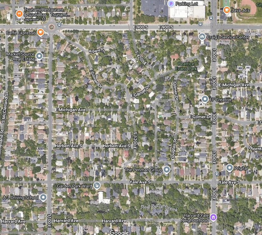
The Gilmer Park Historic District, developed primarily between about 1909 and 1943, is a significant residential neighborhood in Salt Lake City. It is a well-preserved, cohesive neighborhood of 244 buildings, all but two of which are houses and eighty-eight percent of which are contributing structures. The district’s significance is based on three key factors. First, it represents the most intensive period of housing construction in the city’s history, during which virtually all of the farmland on the south edge of the city, where Gilmer Park is located, was transformed into residential subdivisions. Between 1910 and 1930, Salt Lake City’s population increased fifty-one percent with more than 47,000 new residents, and suburban developments accommodated most of that growth. Gilmer Park is one of the most distinct of those subdivisions. Second, a substantial number of Gilmer Park residents were important individuals in the community and state. These included influential businessmen, politicians (including a governor), artists, architects, doctors, attorneys, educators, and religious leaders (including a president of the LDS Church). Third, many of the houses in the district are excellent local examples of important architectural styles and types. The neighborhood was developed between 1909-43, with the majority of building (sixty-two percent) occurring between 1921-8. This period of development, just after World War I, is reflected in the postwar construction boom and the predominant use of Period Revival style architecture in the area. The neighborhood itself, with its curvilinear layout, represents a unique variation in subdivision design in the city. It is one of the first subdivisions in the city to deviate from the rectangular grid and follow the national trend toward more organic layouts.
The Gilmer Park Historic District covers the area east roughly between 1100 East and 1300 East from 900 South to Harvard Avenue and is in the East Central Neighborhood of Salt Lake City, Utah and it was added to the National Register of Historic Places (#96000314) on March 28, 1996. The text on this page is mostly from the nomination form from the national register.
Water, a primary factor in the development of land, and transportation services were in place prior to the development of Gilmer Park Historic District. Water mains were installed on 1100 East in 1892. The area was three miles from downtown Salt Lake City and in response to the need for public transportation because, in 1889 the streetcar system extended to 900 South, and in 1898, the lines were extended to 2100 South on 1100 East. A bus line was in place along 1300 East by 1926.
Roughly bounded by 900 South and Harvard Avenue (1100 South) between 1100 and 1300 East, the district comprises two large properties known historically as the Gilmer estate, from 900 South to Yale Avenue, and the LeGrande Young estate, between Yale and Harvard Avenues. Once this area was primed for development, four sections formed from these estates: Gilmer Park, Gilmer Square, the Young-Howard Estate, and approximately one-fourth of Park View subdivision. Subdivision plats were filed in 1909 for Gilmer Park and 1910 for Gilmer Square. Park View Subdivision was platted in 1889. The Young-Howard Estate was never platted. Construction of the first homes in Gilmer Park Historic District began in 1909 but the majority of the homes were constructed between 1921-8.
Though Gilmer Park Historic District has a cohesive appearance, it was actually created by a number of different owners and developers. The fact that several owners and developers were able to create this visual cohesiveness through the use of curvilinear tree-lined streets, irregular lots, similar house styles, similar scale of houses, and deep set-backs with lawns and landscaping, is evidence of the trend for landscaped subdivisions that began to occur in Utah and across the country. They quickly realized the area’s assets of cleaner air and a unique park-like setting and sloping topography, characteristics that were attractive to home buyers. Capitalizing on the natural features of the district, development was directed at defining a unique, internally-structured, and cohesive neighborhood. Careful and judicious planning extended to the quality of the homes being built.
GILMER ESTATE
The land on which most of the Gilmer Park Historic District was developed originally belonged to the Gilmer family. It was first developed as the Gilmer estate, property that was located between 900 South and Yale Avenue (1080 South) between 1100 East and 1400 East. It was purchased in 1888 by Mary E. and John T. Gilmer from a farmer in the area, Alvin F. Guirvits. John T. Gilmer (1841-92) was a successful mining operator, government mail contractor, and a partner in the Gilmer and Salisbury Overland Stage Company. Mary E. Gilmer (1844-1924) was active in women’s clubs and civic affairs, helping found the Ladies Literary Club and the Sarah Daft Home for the Aged. She was also a local leader in the women’s suffrage movement. In 1889, the Gilmers built a house on the property near the corner of 900 South and 1100 East at the end of a curved driveway which is now part of Gilmer Drive. In 1899, the house and property were leased to the Salt Lake Country Club, Salt Lake’s first and newly organized golf club. The house (originally at 945 South 1100 East) was used as the clubhouse and the surrounding land as the golf course. The Salt Lake Country Club moved to the Forest Dale location in 1907. The Gilmer house was apparently replaced by newer houses built in the 1920s.
Gilmer Realty Company
In 1909, Mary Gilmer and her son, Jay T. Gilmer, organized the Gilmer Realty Company and filed subdivision plats for a portion of Gilmer Park. Gilmer Realty Company was responsible for the initial platting and promotion of Gilmer Park and Gilmer Square, land they owned together with other investors. Their involvement in the development of the Gilmer Park Historic District is significant in initiating the building of a unique neighborhood. Advertisements in Goodwill’s Weekly Magazine show that Gilmer Realty and J.T. Gilmer were involved in developing this area through at least 1914. For whatever reasons, the Gilmers’ role in developing the property diminished and by about 1920 they no longer appear to have been active in the venture. Gilmer Realty Company may have actually built only about thirty homes in the area.
Kimball & Richards Company
It appears that much of the development in Gilmer Park was done by Kimball and Richards Company. Weekly newspaper ads that appear in the 1919 Salt Lake Tribune support their involvement in this area. These ads extolled the virtues of living in Gilmer Park for its location, natural beauty, improvements such as sidewalks, trees, city water and sewer, its regulations that protected it from undesirable surroundings, the individuality of each homesite made possible with the services of an expert landscape architect, and the reasonable price of the lots. Kimball & Richards developed numerous lots throughout the district with the exception of the Gilmer Square.
The company was first listed in the Polk Directory as an insurance and rental company in 1908. By 1910, they had expanded into real estate and development, calling themselves “land merchants.” The firm of Kimball & Richards consisted of three corporations: Kimball & Richards “land merchants,” which marketed subdivisions; Kimball & Richards Building Company, which custom built many of the homes for buyers on lots promoted by the “land merchants”; and Kimball & Richards Securities Company, which provided financing. Taylor Woolley and Clifford Evans, architects that lived in Gilmer Park, designed homes for Kimball & Richards. Kimball & Richards Company was known for its innovative promotion methods and was aware of national trends. In 1910, D. C. Kimball visited Los Angeles and Southern California to study the California market and the promotional methods used there. Both Don Carlos Kimball and Claude Richards were Utah natives and members of the LDS Church. It was one of the most active companies in the early decades of the twentieth century. They developed individual houses and large subdivisions such as Chesterfield, Homefield Acres, and Highland Park. They left their mark indelibly in the growing subdivisions of Salt Lake City. Unfortunately the firm was forced out of business by the mid-1920s because of internal and external economic problems.
Ashton-Jenkins Company
It appears that Ashton-Jenkins Company also had a great deal of influence in the Gilmer Park Historic District. As early as 1909 they owned property in the area between 900-1000 South and 1100-1300 East and in 1913 they were buying land throughout Gilmer Park Historic District.
The Ashton-Jenkins Company was responsible for hundreds of buildings in the Salt Lake Valley between 1890-1945. Edward T. Ashton was a successful builder and architect as well as a talented businessman and developer. He purchased, planned, and developed the Franklin Subdivision, drew plans for and constructed the State Normal School at Cedar City, and erected electrical plants for Telluride Power. In 1881, Edward T. Ashton began a general contracting business and was later joined by his brother Charles S. to form the Ashton Brothers Company. Edward E. Jenkins joined them to form the Ashton-Jenkins Company which became one of the largest real estate companies in Salt Lake City.
Ed D. Smith & Sons
Ed D. Smith & Sons were involved in the Gilmer Park Historic District in about 1916 having purchased property from Clifford P. Evans. Their influence was apparently throughout the district. Newspaper articles show they were developing lots between 900 South and Yale and 1100 East and 1400 East, with several hundred homes planned for construction. In 1916, plans were formalizing for street improvement work with plans to grade part of Gilmer Drive. This company also brought influences from outside Utah. For example, in 1916 a news article about Gilmer Park and Ed D. Smith & Sons reported that a “prominent California landscape gardener was brought here from California to plan the park, and it promises to be a delightful spot, with the broad, curved driveways, parkways, tennis courts, shrubbery and groves.” Gilmer Park was also described as a place that could be easily accessed by motorists, offered great views, and was apart from the grime of the city.
Other Developers
Vincent-Peterson Construction, owned by J. G. Vincent, who lived in the area (1220 Yale Ave.), was involved in building five homes on Gilmer Drive in addition to many others in the area. Waddoups Company (1922-5) and Morrison-Merrill Company (1925-7) were also developers in the area.
GILMER PARK SUBDIVISION (1914-43)
The subdivision known as Gilmer Park extended south to Yale Avenue and east to 1400 East, excluding Michigan and Herbert Avenues (the Gilmer Square Subdivision). The owners of the subdivision included Gilmer Realty Company, Taylor and Dorrit Evans Woolley, Evelyn J. Burton, J. G. and Winnie B. Vincent, and George E. and Lillian C. Merrill.
What was originally the Gilmer Park Subdivision is the largest portion of the Gilmer Park Historic District. Its primary period of development was between 1914-43, with the majority (approximately eighty-five percent) of the building occurring between 1921-30, although a few homes were built prior to 1920. Restrictions placed on the buildings were made to “insure beauty and permanence that should enhance the value of the property.” The minimum construction cost was set at $3,000 with the majority of the homes starting at $3,500 to $4,000. The landscape plan for a portion of Gilmer Park, primarily around Alpine Place, was designed by Taylor Woolley.
GILMER SQUARE SUBDIVISION (1910-26)
The Gilmer Square Subdivision, platted on April 4, 1910, was owned by Gilmer Realty and LeGrande Young. It included the lots along Herbert Avenue, the south side of Michigan Avenue, and the north side of Yale Avenue between 1100 East and 1200 East. The majority of the building in this subdivision occurred between 1914-26. In a Salt Lake Tribune advertisement, Gilmer Realty stated that some of the features of the subdivision were: a $4,000 minimum building cost restriction; extensive public improvements including sidewalks, city water, graded streets, perfect drainage, and a street car line; and it was considered “the last close-in residence division of the better class.
One of the earliest houses in the subdivision was built in 1910 for Jay T. Gilmer (1038 South 1200 East) at a cost of $6,000. It was designed by two prominent Utah architects, Frederick A. Hale and Charles S. McDonald. Drawings of Jay T. Gilmer’s home were used to promote the Gilmer Square development in newspapers and magazines. The majority of development in the subdivision began in 1915.
LEGRAND YOUNG ESTATE
The LeGrande Young estate, between Yale and Harvard Avenues, was obtained in 1887 by LeGrande Young (nephew of Brigham Young) from his uncle, Lorenzo Young. LeGrande built a home c.1890 on the site now occupied by the Garden Park Ward and began planting a wide variety of trees including oak, plum, apple, pear, cherry, Boston elm, silver leaf poplar, and horse chestnut. His efforts resulted in beautiful groves and gardens for which the area became well known and which later attracted people to this area. The gazebo, pond, brick wall, and carriage house which are still located on the property were part of this estate.
YOUNG-HOWARD ESTATE (1918-39)
In 1914, Young sold the entire estate to John C. Howard, a prominent Salt Lake businessman and community leader who served, among other positions, as president of Utah Oil Refining and president and director of the American Mining Congress. Howard sold some of the parcels of land, but retained the two-and-one-half acres that now constitute the Garden Park grounds. The area immediately surrounding the Howard estate was developed primarily during the early 1920s, without being officially platted as a subdivision.
Howard and his wife, Gertrude Musser, lived in the home built by LeGrande Young with their four daughters until their deaths in 1929 and 1919, respectively. After Mr. Howard’s death, three of his daughters lived in the house until 1938. Apparently they had planned to add on to the house before it was deeded to the LDS Church. In that same year, a chapel designed by architects Taylor Woolley and Clifford Evans, both ward members, was built on the foundation of LeGrande Young’s home and the foundation of what was to have been a new house for the Howards. At first the building was called the Gilmer Park Ward, but was later changed to Garden Park Ward.
PARK VIEW SUBDIVISION (1909-27)
The portion of the Park View Subdivision in the Gilmer Park Historic District is the south side of Harvard Avenue between 1100 East and Douglas Street. LeGrande Young was the owner and developer of the subdivision, which is located directly south of the Young-Howard Estate. LeGrande Young purchased the property from William G. Timmons on March 3, 1889, for a reported $12,000, and a plat for the Park View Subdivision was filed on October 23, 1889. This portion of the subdivision was apparently undeveloped until about 1909.
In 1914, LeGrande Young moved from his estate located between Yale and Harvard Avenues to his newly built home across the street from Park View at 1121 Harvard Avenue. His children also built homes in the subdivision primarily on the south side of Harvard Avenue: Grace Young and Kenneth Kerr (1172 Harvard Avenue, 1909); Lucille Young and William Reid (1150 Harvard Avenue, 1905); and LeGrande Young, Jr. (1218 Harvard Avenue, 1910).
The only portion of Park View included in the Gilmer Park Historic District are the lots on the south side of Harvard Avenue west of Douglas Street. Houses were built on lots along this part of Harvard by 1920. The lots on the east side were developed a few years later. This section of the Park View Subdivision is included within the boundaries of the Gilmer Park Historic District because of the connections with LeGrande Young’s family throughout this district and because of the visual cohesiveness and similar scale of houses.
CONTEMPORARY SUBURBAN DEVELOPMENT
The earliest suburbs were thought of in a different light than they have been perceived in the 1950s through today. Early suburbs were sub-urban, or not fully urban. By the late 1890s, suburbs were occupied mostly by upper class families because they could afford a retreat from the city heat and filth. The residential developments outside the urban setting were considered a retreat from the grime and grit of the city and afforded the middle and upper classes a chance to have the American dream of a single family home that accommodated private space inside and outside. By 1910 things changed and the middle- and working-class citizens were moving out to the suburbs by the thousands, facilitated by public transportation. People moving in from the farm and out from the city combined to create an altered architectural pattern. With this came the creation of a significant architectural type — the suburban house form. 33 It wasn’t until the advent of the post-WWII housing development that the pastoral qualities of the suburb of the late 19th and early 20th century began to vanish.
The urban space, divided into plain rectangular strips without concern for topography or aesthetics and whose gridiron plan produced straight streets intersecting at right angles, appealed to the city residents’ preference for rational solutions and scientific methods. It was a practical approach for ordering space and simplified surveying and facilitated speculation. Early suburbs followed this plan because the rectangular layout of the streets extended beyond the city to make easier the sale and resale of lots possible in advance of settlement; it also stimulated promotion of undeveloped areas. “The price that the grid exacted in ugliness appeared small in a strange world where monotony also suggested familiarity.”
Just after the turn of the century the suburban form began to change. The increased cost of real estate in the city led land speculators and real estate developers to survey fields and meadows, imprinting streets and creating a landscape, neither rural nor urban, where people could enjoy both city and country lives. Profits were abundant for developers of the early twentieth century. Some learned that greater profits could be realized from “new arrangements of streets and structures, from new building materials, and from integrated beauty.” People in search of rural settings and something “unique would force private developers to reach new levels of residential design and new levels of profit.”
Large-scale suburbs on curvilinear street systems, like Vandergrift, Pennsylvania, were planned as early as 1895 by Frederick Law Olmsted, Jr. Olmsted (landscape architect of the nineteenth century) had outlined the requirements of city planning. His plan stated that first, main thoroughfares “should be direct, ample, and convenient no matter how they cut the land.” Second, other roads must be “quiet, attractive” residential streets, not “fantastically rooked,” but laid out “so as to discourage their use as thoroughfares.” Third, was the necessity of park land and public open spaces. Although Olmsted was successful in influencing planning patterns throughout the country, his work, along with that of Grosvenor Atterbury, an architect of equal reputation, and the Sage Foundation in their c.1911 development of “Forest Hills Gardens produced almost no progeny.” This lack of influence is believed to have been caused primarily by the village or company town appearance which overshadowed the efforts of backers and designers. Other planned subdivisions such as Shaker Heights, developed beginning in 1911 by the Van Sweringen brothers outside of Cleveland, did influence many residential developments. These developers controlled the building in this area by reviewing the plans of a number of different architects and landscape architects. “Forest Hills Gardens and Shaker Heights reflect something of the range of the early twentieth-century planned residential development.” Some suburban developments were not successful while others continue to be known.
Some subdivisions were developed to follow the natural topography. Roads followed the trails established when lands were first settled; bridges were built where ferries had terminated; old hedgerows and trees were surprisingly often preserved as “salable features.” Post-Victorian suburbs were individualistic, egalitarian, and comfortable. The idea was to live in a location far enough from the city to have rural qualities that included an open field nearby, a garden behind, and a front lawn, while living close enough to commute to the city to earn a living. This was a new era for housing development. The suburbs were practical because land was less expensive and afforded an individual home on a lot. They provided psychological advantages because they were “images of sturdy independence in their apartness from their neighbors.” And, they were traditional as an American idea and historical experience in contrast to European. The American house-designer conceived of houses as individual units set in landscapes rather than one among many similar buildings.
By the mid-1920s Salt Lake City mirrored the national trends of contemporary planning. Growth in the city during this period was occurring primarily to the east and south of the city center and between 1906-30, 439 new residential subdivisions were recorded with the county recorder’s office. Land subdivision was relatively stable during this period and was marked by the desire to make the city a good place to live.
Unlike many other developments in Salt Lake City during the early twentieth century, Gilmer Park Historic District “distinguishes itself through unusual skill and sensitivity applied to the layout and design of both the area as a whole and the individual structures.” Gilmer Park Historic District is believed to be the one of the first subdivisions in Salt Lake City developed using curvilinear streets, a layout that was considered a more progressive design. According to architectural historian, Gwendolyn Wright, the “increasing reliance on the car had many effects on residential planning to make driving more pleasurable, some developers abandoned the familiar rectilinear grid street and laid out wide, curving streets and cul-de-sacs.”
Federal Heights, roughly bounded by Virginia Street, University Street, First South, the University of Utah, and the foothills of the Wasatch mountains, is the only other known similarly planned subdivision that occurred as early as Gilmer Park Historic District. Telluride Real Estate Company began developing the area in 1909 and named it Federal Heights in reference to the government’s previous ownership of the property and its neighbor, Fort Douglas. The street patterns were designed to take advantage of the sloping topography and to create greenspaces within the neighborhood. Federal Heights, like Gilmer Park, has maintained its historic integrity and widespread identity. Slight differences occur in the scale of the homes from those in Gilmer Park as the number of large-scale residences in Federal Heights are greater. Also a number of the roads in Federal Heights are wider. Overall, however, the similarities between these two neighborhoods are strong and both reflect the a particularly successful pattern of subdivision development during the early 1900s in Salt Lake City.
Other suburban developments in Salt Lake City of about the same time did not follow the planned landscaped community as completely as did Gilmer Park. Westmoreland Place, with entrance gates at 1500 East and 1300 South, was platted in 1913 just a few years later than Gilmer Park and developed by Earl and Clark Dunshee. Amenities similar to those found in Gilmer Park included the landscaped green spaces and the idea of using parks, but it maintained the rectilinear street grid.
Highland Park was developed by the firm Kimball & Richards Company. Boundaries for this subdivision are roughly between Elizabeth Street (1140 East) and 1500 East, from Parkway Avenue (2400 South) to 2700 South. Highland Park was built primarily during the period between c. 1910-25 in a rectilinear plan. Kimball & Richards generally followed the typical pattern of subdivision layout, promotion, and development that had been established during the 1890s. They did include the planting of shade trees and terraced yards.
Many areas were developed not as a single subdivision but by speculative developers purchasing a few lots within an area. For example, the University Neighborhood Historic District, roughly bounded by South Temple and 500 South between University and 1100 East, was not a ‘subdivision’ and in addition to its single-family residences there are numerous apartments, and commercial buildings.
Gilmer Park’s planning and development by the individuals who owned and developed the area was intended to define an internally-structured and cohesive neighborhood. The visual quality of the district is created by a combination of several factors: the sloping terrain, curving streets, sloped or terraced yards, uniform setbacks and spacing, landscaping, and the architectural quality of many of the homes. While all subdivisions in Salt Lake City were named when they were developed, few remain easily identifiable today. Gilmer Park has withstood the test of time and most people recognize the name with the area that is being designated for nomination.
Gilmer Park influenced the development of other subdivisions in the area. Later subdivisions to the east of Park View were the site of many middle- and upper-middle-class residences located on tree-lined, lamp-lit, serpentine streets. This area is known as the Harvard/Yale area having been given ivy league street names as a result of the city engineer’s attempt to provide a standardized system of naming streets in the various residential developments. Harvard/Yale, like Gilmer Park, is one of the few most recognized residential neighborhoods in Salt Lake City.
Gilmer Park Historic District is also important because it contains numerous buildings that are both significant and modest examples of the work of prominent Utah architects. Since several architects participated in the subdivision’s development, their awareness of current trends in suburban planning no doubt influenced its plan. Layout of much of the Gilmer Park area is attributed to Taylor Woolley, a prominent Utah architect. He apprenticed with Frank Lloyd Wright in the early 1900s and apparently brought that influence to his work in his layout and landscaping of lots along Gilmer Drive. His plan for a section of the district shows several homes located on spacious lots on Alpine Place. Although those particular houses were never built, the layout has remained intact with curvilinear streets and deep setbacks, including a private alley that leads to a group of garages. It is unknown whether Woolley designed other curved streets in the subdivision, but his influence is obvious. The architectural firm he formed in 1917, Miller, Woolley, and Evans, was one of the first to include a landscape architecture department. They did not limit their designs to buildings but included the planning of the State Capitol grounds and Memory Grove. Woolley’s firm also influenced the architecture in the area. He and his brother-in-law, Clifford Evans, designed the Garden Park Ward Chapel located at 1150 Yale Avenue. Other houses in the district that may have been designed by Woolley include 1016 Douglas Street and 910 South 1200 East. He also designed several notable Prairie School style homes just east of 1300 East on Yale Avenue.
Other architects who influenced the area included Frederick A. Hale and Charles S. McDonald, who are known to have designed J.T. Gillmer’s residence (1038 S. 1200 E., 1910). Hale designed more than one hundred buildings in Salt Lake City including the Alta Club, the First Methodist Church, the Keith-Brown mansion, and numerous residences. Charles S. McDonald, of the firm McDonald and Cooper, worked with Hale on the addition to the Alta Club, designed the Keith O’Brien building, and worked with Eames and Young on the Walker Bank building.
Gilmer Park Historic District contains large number of excellent examples of the styles popular in Salt Lake City and Utah during the period of significance, 1909-43. The houses display the craftsmanship of design and construction materials associated with the era of the significant period. Attention was paid to the quality of design and cohesiveness in the neighborhood. The residential building styles are predominantly Period Revival Cottages and Bungalows and portray the sequence of its development and its association with the growth of the city during a progressive era.
The majority of buildings constructed in the district were bungalows and period revival cottages. Nearly twenty-nine percent of the homes are bungalows, either Arts and Crafts or Prairie School. These styles were popular in Utah from 1905-25 and incorporated many similar stylistic features such as low, hipped roofs and wide, overhanging eaves. The wide porches help to create an impression of informal living and unite the houses to their sites. The bungalow plan is open, informal, and economical and became the basic middle-class house, replacing the late-nineteenth century Victorian cottage. Like the Victorian style, the bungalow’s popularity can be attributed to the widespread use of architectural pattern books and a corresponding period of economic prosperity when many families were purchasing their first homes.
Approximately sixty-four percent of the homes in the district are Period Revival English Cottages, English Tudor, and Colonial Revival homes. Period Revival styles were popular in Salt Lake City and throughout Utah primarily between 1920-40. Most of the Period Revival homes in Gilmer Park Historic District were constructed in the 1920s. A possible reason for the rise in popularity of the Period Revival style may have resulted from national pride following World War I which led to its increased use. English Tudor, Spanish Revival, and French Norman styles were most likely imported by soldiers returning from the war in Europe. These designs were based primarily on external decorative features rather than the historical building and planning traditions and “were simplistically massed, suggesting the informality that various architectural writers of the period stated was appropriate to the American way of life.”
PROMINENT RESIDENTS OF GILMER PARK HISTORIC DISTRICT
Gilmer Park Historic District is also significant because of its association with prominent residents who contributed to the growth and progress of Salt Lake City and the state. The influx of professionals were an indication of the progress the city was experiencing and greatly influenced the growth and social fabric of the neighborhood and ensured its viability. The neighborhood has been home to many of Salt Lake City’s prominent residents who were influential in business, politics, art, architecture, medicine, law, education, and religion.
A look at the lives of many of the residents in the district reveals that the district was home to many prominent citizens involved in business, politics, architecture, art, law, medicine, education, and LDS Church activities. Those who chose to make Gilmer Park their home came from all walks of life, although residents were generally upper-middle class.
Many Gilmer Park Historic District residents were politically influential. Wilson McCarthy, state senator, governmental appointee, and president of Denver and Rio Grande Railroad, lived at 974 South 1300 East between 1924-32. Elise F. Musser, state senator and governmental appointee, and her husband Burton W. Musser, state senator and attorney, resided at 1133 Harvard Avenue. Elise lived there until her death in 1967 and Burton lived there through the 1980s. Elizabeth P. Hayward, also politically active as a state legislator and with the Democratic National Committee, lived at 1140 Herbert Avenue between 1917-28. Finally, Herbert B. Maw, a former governor of Utah, lived at 1212 Yale Avenue between 1939-80s.
A number of residents were prominent in business. Earl F. Free (1205 Gilmer Drive) was the founder and manager of Carbo-Chemical Group and also Hygeia Ice Company. Harold H. Bennett lived at 1187 Harvard Avenue between 1930 and the 1980s and was the president of Zion Cooperative Mercantile Institution (ZCMI). Samuel H. Sharman (1159 Gilmer Drive, 1925-38) was vice-president and general manager of Sharman Automobile Company and was also a nationally famous trap-shooter. Between 1922-36, Simon Rosenblatt, vice-president of Eimco and founder of Grand Central Stores, lived at 1277 Yale Avenue.
A University of Utah economics professor and governmental appointee, Mark H. Green, lived at 1127 East Alpine Place between 1933-49. Other professionals who lived in the area included Walter M. Stookey (1270 Yale Avenue, 1923-35) and Rush B. Stevens (1236 Yale Avenue, 1924- 37) who were physicians, and Murray P. Rock (1120 Yale Avenue, 1922-27) who was a dentist.
Many residents were also known for their accomplishments in art and architecture. Gilbert P. Riswold (1252 Gilmer Drive, 1924-31) was a sculptor. Three prominent Salt Lake City architects lived on 900 South between 1200 and 1300 East on what has been called “architects row.” Taylor Woolley lived at 1222 East 900 South from 1918 until his death in 1965. His brother-in-law and partner, Clifford P. Evans resided at 1266 East 900 South. Harold W. Burton, of the firm Pope and Burton lived at 1226 East 900 South.
LDS Church leaders also made their home in Gilmer Park Historic District. Richard L. Evans lived at 1032 Douglas Street between 1936-71 and was best known as the radio announcer for the nationally broadcast radio program, “Music and the Spoken Word.” Sterling W. Sill who resided at 1264 Yale Avenue from 1935 through the 1980s was bishop of the Garden Park Ward and a member of the Quorum of the Seventy. Adam S. Bennion was a member of the Council of the Twelve and a United States Senate candidate who lived at 1183 Herbert Avenue between 1918-58. Joseph Fielding Smith (998 Douglas Street, 1926-53) was the tenth LDS Church president.
SUMMARY:
Gilmer Parks’ distinctiveness lies in its break with the street grid pattern that dominated the development of Utah cities. Rich in history and architectural significance, the Gilmer Park Historic District is one of the best-preserved and well-designed twentieth-century suburban neighborhoods in Salt Lake City. The influence of the people who lived in this area is evident through their political and professional affiliations and leadership. The unique qualities of the neighborhood combined with the people who continue to value these qualities remains strong. The original owners resided in their homes in Gilmer Park Historic District for relatively long periods of time. Residents in the neighborhood continue to take great pride in their homes and streets by maintaining their houses and yards. A strong neighborhood association was formed about ten years ago and continues to be very active today.
The Gilmer Park area was part of a tremendous building boom in Salt Lake City. At the turn of the century, Salt Lake City experienced a major shift in demographic patterns. The population of Salt Lake City increased from 20,000 in the 1880s to well over 92,000 in 1910, and the physical structure of the city rapidly expanded upon higher land to the east and south of the original town grid. The accumulation of a smoke haze over the city had also been a problem in the late 1800s, with coal-fired furnaces and smoke-producing industries exacerbating the problem. During the winter the entire valley was frequently engulfed in a black curtain of smoke particles that marred buildings and clothing. Salt Lake City was so plagued with smoke during the early 1920s that it was nicknamed “the Pittsburgh of the West.” As the population grew, people moved away from the center of town. There was a need and a desire for residents of Salt Lake City to move to higher ground for cleaner air and water. After the problems of acquiring a suitable water supply and sewer system for the bench lands were alleviated, suburban development began to increase. From 1906-30, there were 439 new residential subdivisions platted in Salt Lake City. By 1911 the city consisted of compact residential areas and well-established transportation lines, and in 1922 zoning was established in response to the problems of indiscriminate commercial, industrial, and residential development in all parts of the city.
Nationally the Progressive Era was effecting social changes through governmental reform and the related City Beautiful movement encouraged the design of public spaces that would improve urban life. The movements that defined the early twentieth century, the Progressive Era and the City Beautiful Movement, were also aimed at improving urban life and bringing rational order and efficiency to the forces of progress that had begun in the past century. Private citizens and Salt Lake City’s government moved to join the City Beautiful movement. In 1900, they planted trees in local parks and around the City and County Building, and improved walks and drives in Liberty Park, then considered a showplace of Salt Lake City open spaces. In 1908, due greatly to pressures by the Civic Improvement League, the city established a park board to make Salt Lake into a “City Beautiful”. In 1909 a Parks and Playground Association, with members largely from upper-middle class was formed to provide playgrounds for children. Civic improvements throughout the city included the planting of trees and building of sidewalks.
During the Progressive Era, the first two decades of the twentieth century, Salt Lake City underwent industrialization and urbanization like other cities across the nation. It experienced a shift from an agricultural to a commercial and industrial economy. The city was no longer isolated but was politically and economically integrated into the mainstream of the country. In general, Utah experienced the commercialization of agriculture, the emergence of a substantial business sector, and the development of corporate mining and manufacturing. The combination of agriculture, mining, manufacturing, commerce, and transportation produced prosperity for Salt Lake City.
In the early 1920s Salt Lake City and Utah experienced a postwar World War I economic slump. Although construction, retail trade, transportation, and communication contributed to overall growth, the city experienced an economic plateau in the mid 1920s and did not participate in the national prosperity of that decade. Building, however, was very strong during this period, even with the higher building material prices and interest rates. The demand for new construction was great due to the need for private homes, the building of which had been curtailed during the war. Gilmer Park Historic District provides evidence of this period of building.
The Hall house is one of the best examples of the Spanish Colonial Revival style in Salt Lake City. Especially significant are the tiles of the front entry. They are probably the work of Ernest Batchelder, an important southern California artist of the Arts and Crafts period. The house was built for Nels G. Hall, a prominent businessman, and designed by the architect Slack Winburn and his sons. Hall desired a simplicity and elegance in the exterior design and a functional interior, which are reflected in the house.
The Nels G. Hall House is located at 1340 East Second Avenue in the Avenues of Salt Lake City, Utah and was added to the National Register of Historic Places (#80003923) on October 3, 1980. The text on this page is from the national register’s nomination form.
Nels G. Hall was born on December 29, 1884, in Provo, Utah, a son of Nels and Josephine Bergstrom Hall. He was educated in Provo and graduated from Brigham Young Academy’s School of Business. He married Hazel Greaves at Ephraim on September 5, 1910. They had three children; Katherine, Jeanne and Nels G. Hall.
Hall’s business career began in 1905 when he moved to Salt Lake City to accept a position with the Utah Savings and Trust Company. He then became assistant to Heber M. Wells, who later became the first governor of Utah, in 1914 Hall helped create the Columbia Trust Company and became vice president. In 1920 he left to become secretary-treasurer of the Panama Sugar Company. He soon returned to Salt Lake City to become manager of the Utah Wholesale Grocery, and at that time lived at 275 llth East. He then assumed vice presidency of the Columbia Trust Company and entered into the mining business with several business associates, forming the South Mountain Mining Company at Jordan Valley, Oregon. It was during this period of Mr. Hall’s life that he began the plans for the house. He had visited California and resolved to build a Spanish Colonial or Mission style similar to houses he had seen, and eventually decided on the Spanish Colonial Revival plans. In 1945 Hall sold the mining company and devoted his time to personal investments and business. l He was active in the Church of Jesus Christ of Latter-day Saints in the Federal Heights Ward, and he was also active in civic affairs.
Nels G. Hall lived in the house from the day it was ready to occupy until his death at the age of 80 on December 31, 1964. His widow, Hazel, remained in the house until her death some six years later. Their only son, Nels, lived in the home a short time until his untimely death in 1971. The house remained vacant as such for five years and later occupied by Dr. Alien S. McGaughey. The Thomas Buranek family are the current residents.
Nels G. Hall hired the architect Slack Winburn and his son to design a house similar to Spanish-style houses he had seen in California. According to Hall’s daughter, he wanted simplicity and elegance in the exterior design and a functional and warm interior. The builder was J.H. Johnson.
The exterior appearance of the house is in keeping with the simplicity and elegance desired by Mr. Hall. The principal building material is brick, with a stucco finish. The house has a very solid appearance, with the windows recessed from the exterior façade about six inches. One exception to the brick construction is a frame extension of the master bedroom in the rear of the house. This is also covered with stucco.
Wood was used on the exterior of the house mainly for the cornice and the openings. Doorways, window frames, balconies and support posts in the rear of the house are wooden. There is also a small wooden deck extension in the rear. Simple wooden posts support a roof over a sun porch located above the concrete garage. The garage is partially underground, and was built at the same time as the original structure.
In the Spanish Revival style chimneys were commonly placed in the interior of the house. The Hall house, however, has both its chimneys located on the exterior walls, one on; the east and one on the west façade. The physical appearances of the two chimneys are in keeping with popular designs used for this style. One chimney is used for two fireplaces, one below the other.
The wooden posts which support the rear extension of the second floor (the master bedroom) are designed in the style of the Spanish Colonial Revival. Two posts are placed very close together, as if to resemble a single post. A common feature of the Spanish Colonial Revival style is the balcony. Typical balconies are long and extend around a portion of the exterior. Two balconies are situated on the Hall house on the street façade, second floor. The first is made of wood, with panels having a cutout sun motif in the center. These panels of wood were quite common for privacy as well as for wind protection. The second balcony, around the corner from the other, is ornamented with wooden spindles.
One of the loveliest features of the house is the front door surrounded by beautiful ceramic tiles. These tiles were probably the work of Ernest Batchelder, an artist of the Arts and Crafts period who lived and worked in southern California. The tiles depict popular Spanish motifs. Extra tiles were purchased in case tiles were damaged by weather or age. These tiles were ordered, as were the roofing tiles, through the Cahoon Brick Company.
The Hall house main floor plan consists of a living room, dining room, breakfast room, study, kitchen and one-half bath. There are two fireplaces on the main floor. On the second floor, there are three bedrooms, a full bath, and the master bedroom is in the rear of the house. The lower level consists of an amusement room, a bedroom, a laundry room and a three/quarter bath.
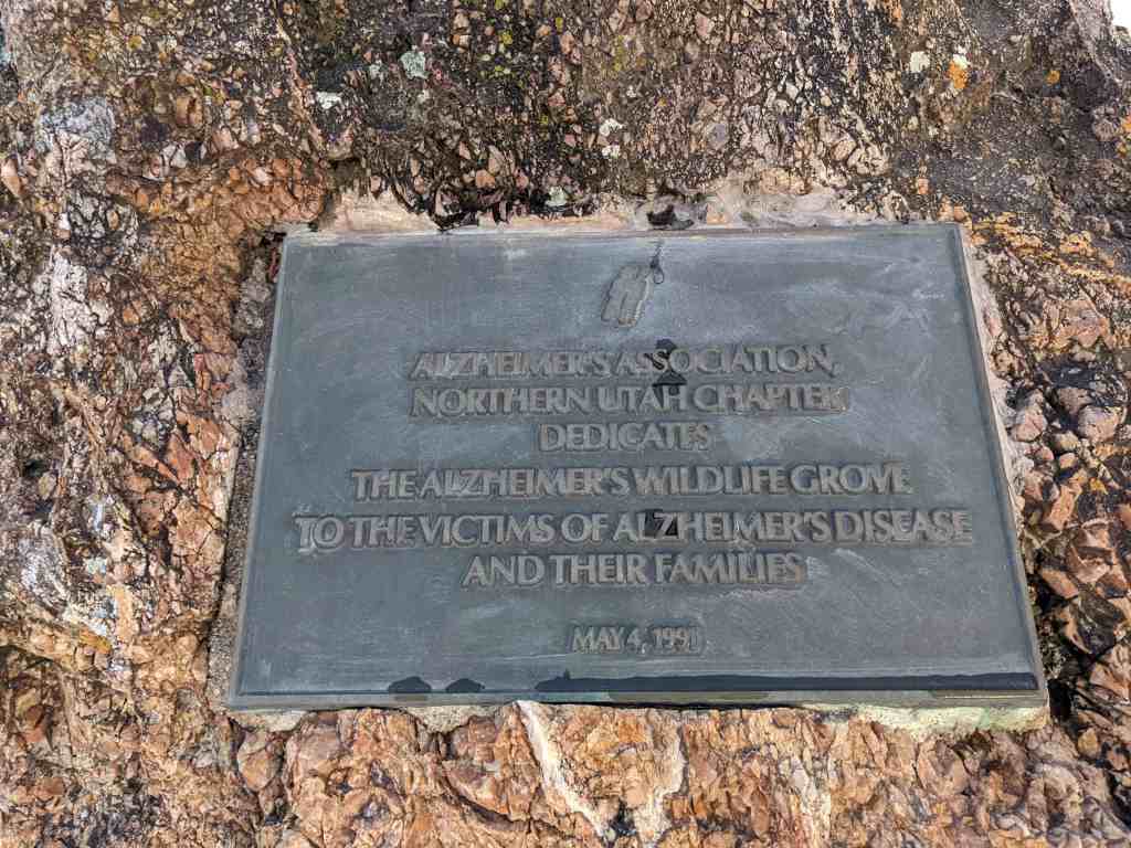
Alzheimer’s Association Northern Utah Chapter Dedicates The Alzheimer’s Wildlife Grove To the victims of Alzheimer’s disease and their families May 4, 1991
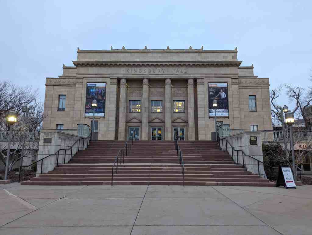
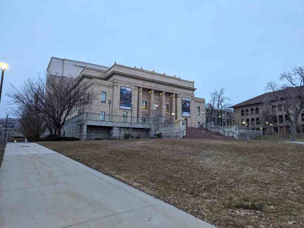
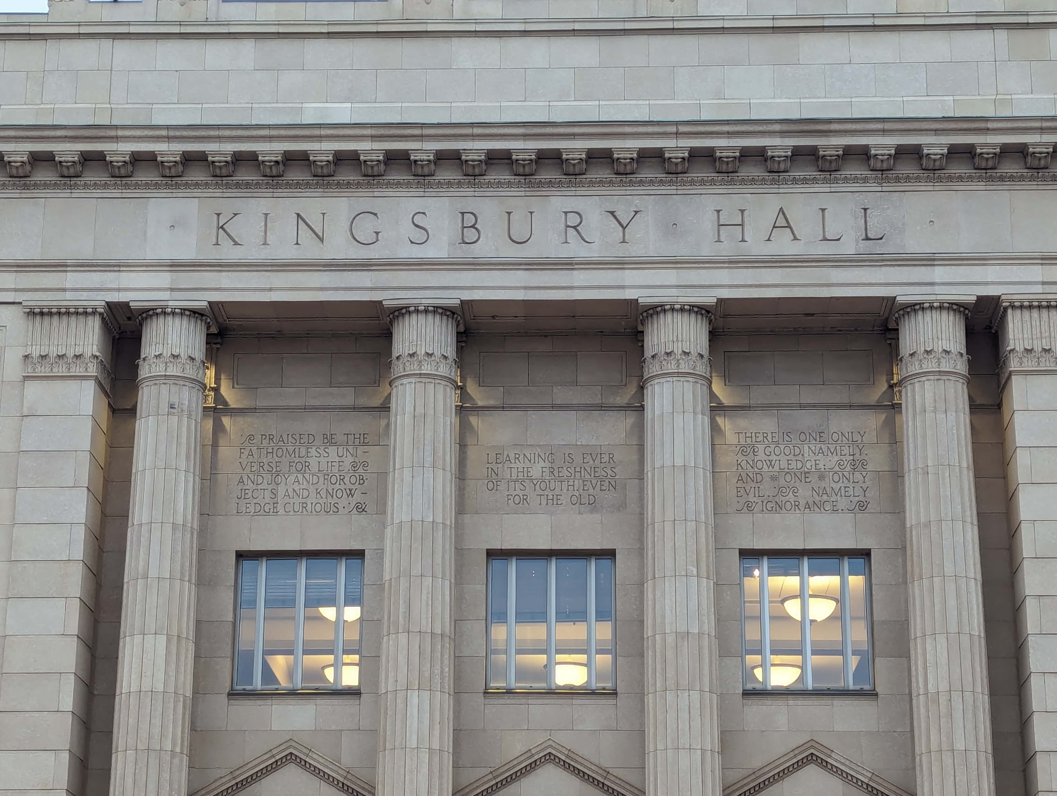
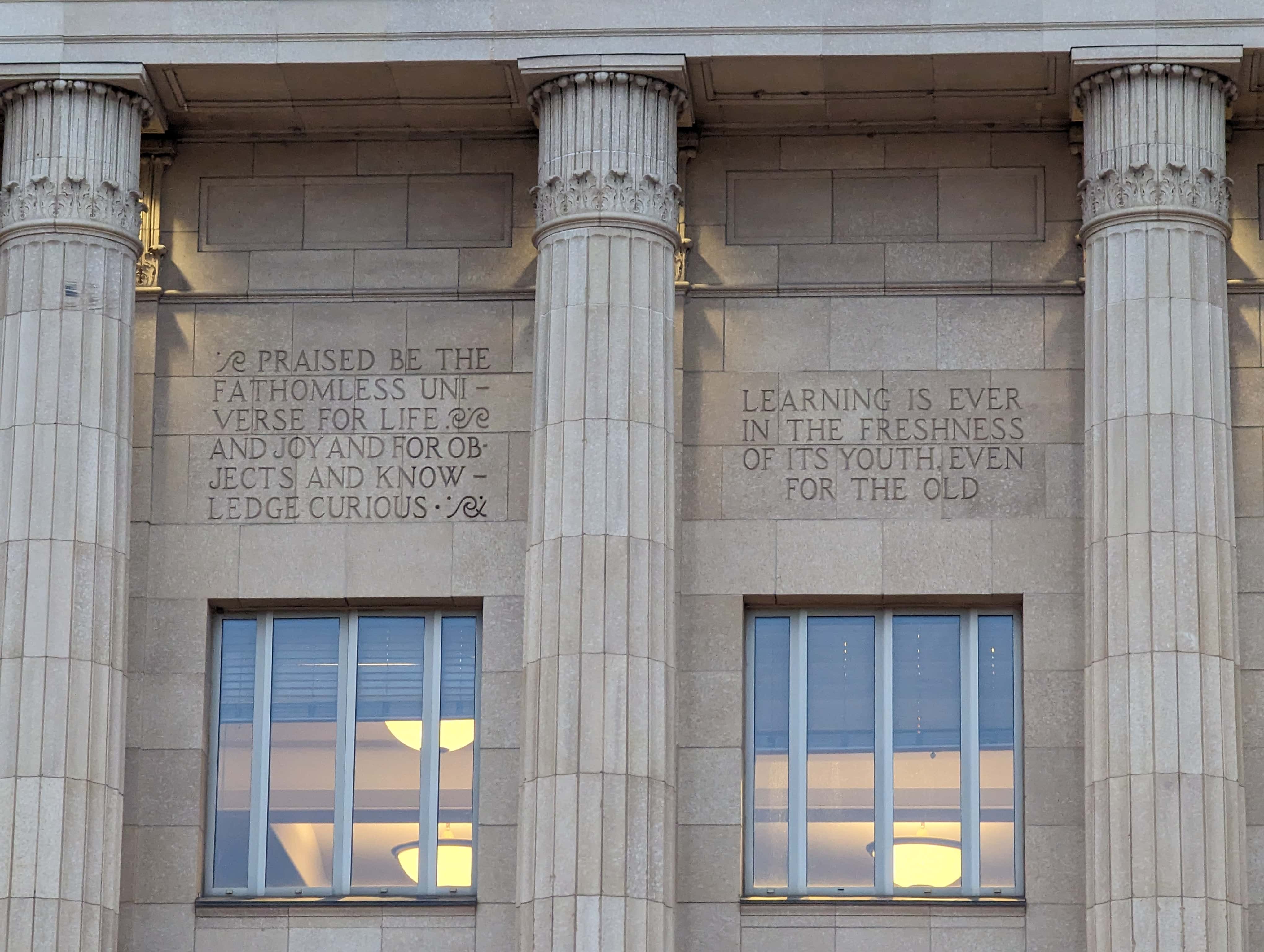
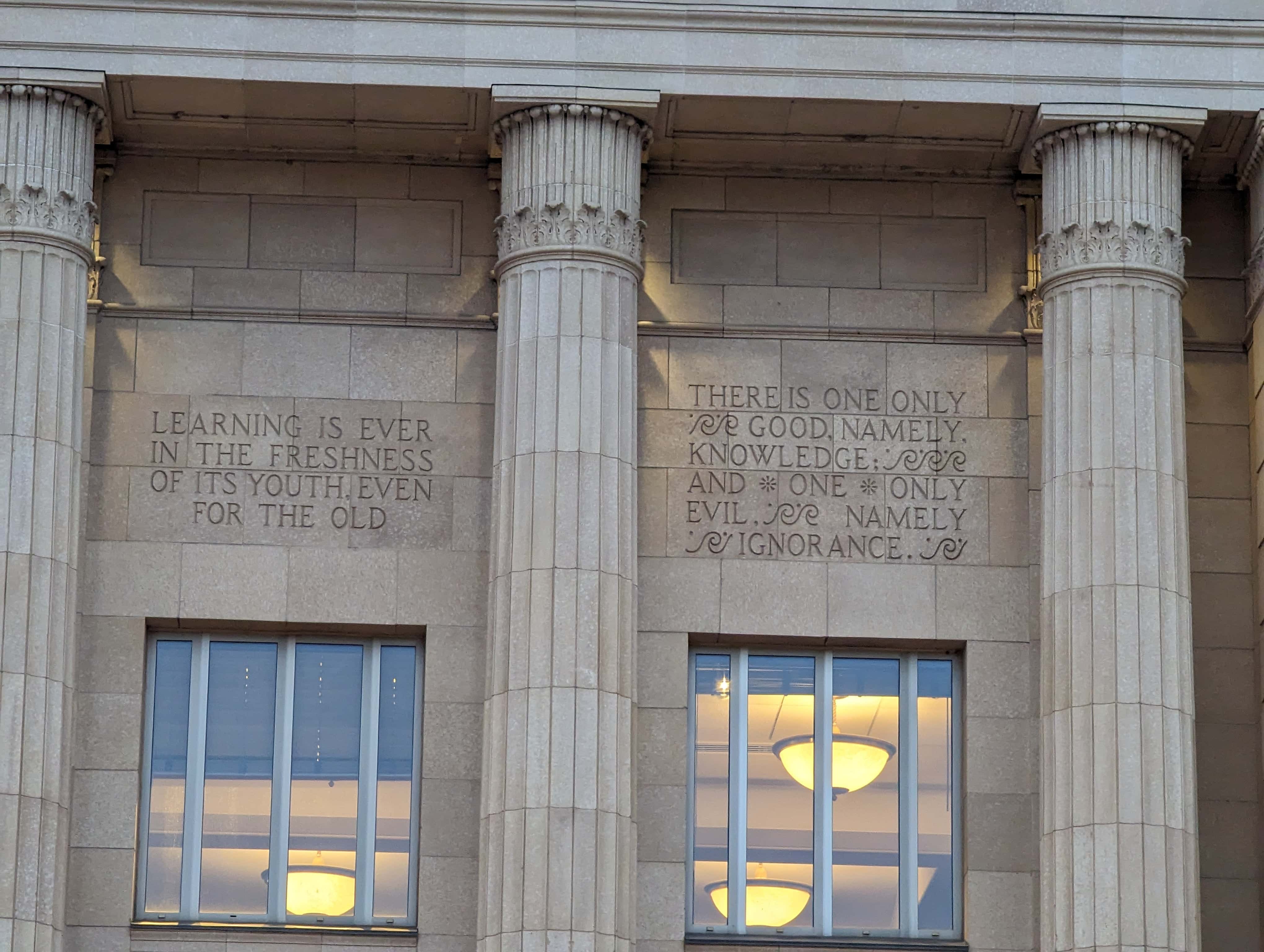
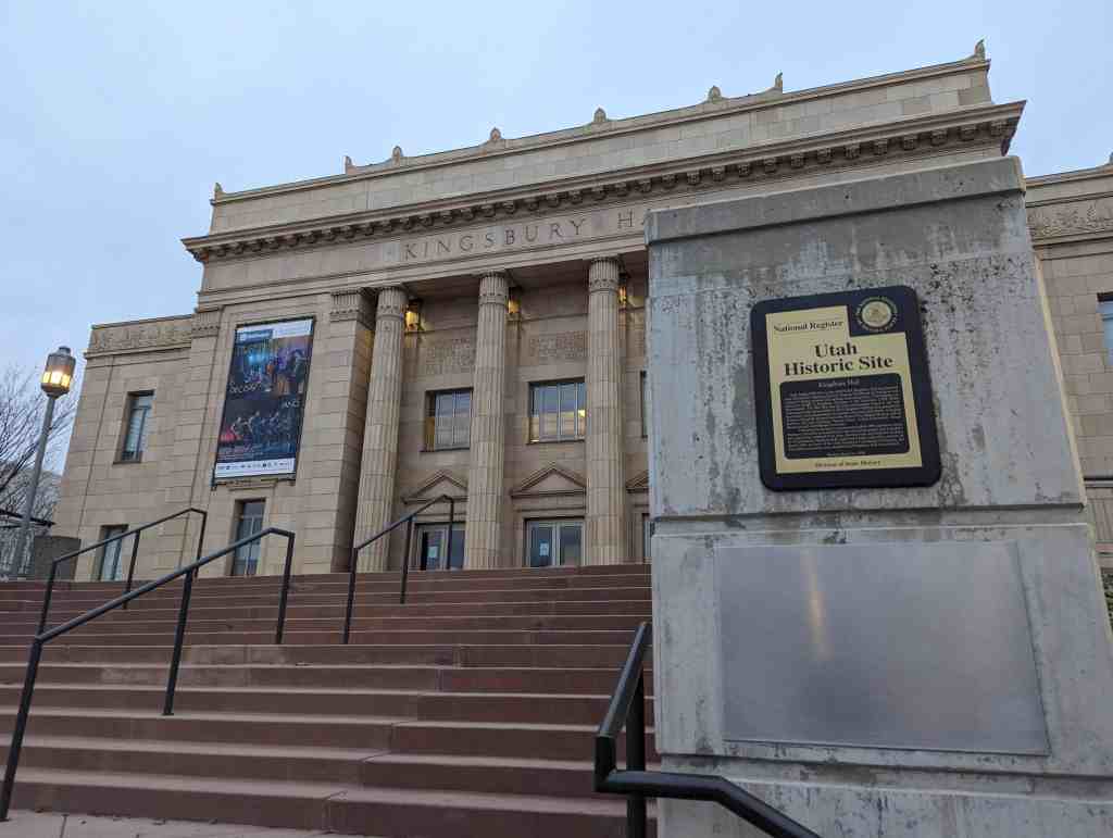
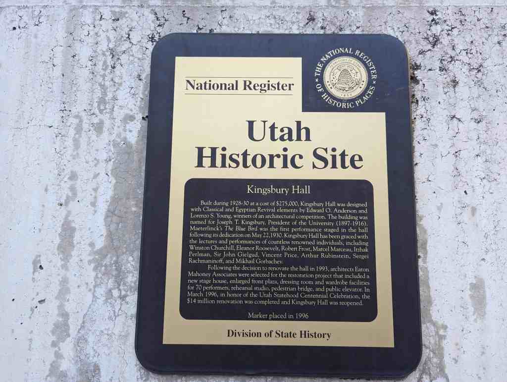
Built during 1928-30 at a cost of $275,000, Kingsbury Hall was designed with Classical and Egyptian Revival elements by Edward O. Anderson and Lorenzo S. Young, winners of an architectural competition. The building was named for Joseph T. Kingsbury, President of the University (1897-1916). Maeterlinck’s The Blue Bird was the first performance staged in the hall following its dedication on May 22,1930. Kingsbury Hall has been graced with the lectures and performances of countless renowned individuals, including Winston Churchill, Eleanor Roosevelt, Robert Frost, Marcel Marceau, Itzhak Perlman, Sir John Gielgud, Vincent Price, Arthur Rubinstein, Sergei Rachmaninoff, and Mikhail Gorbachev.
Following the decision to renovate the hall in 1993, architects Eaton Mahoney Associates were selected for the restoration project that included a new stage house, enlarged front plaza, dressing room and wardrobe facilities for 70 performers, rehearsal studio, pedestrian bridge, and public elevator. In March 1996, in honor of the Utah Statehood Centennial Celebration, the $14 million renovation was completed and Kingsbury Hall was reopened.
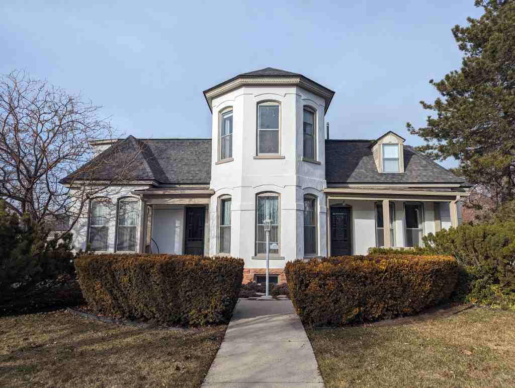
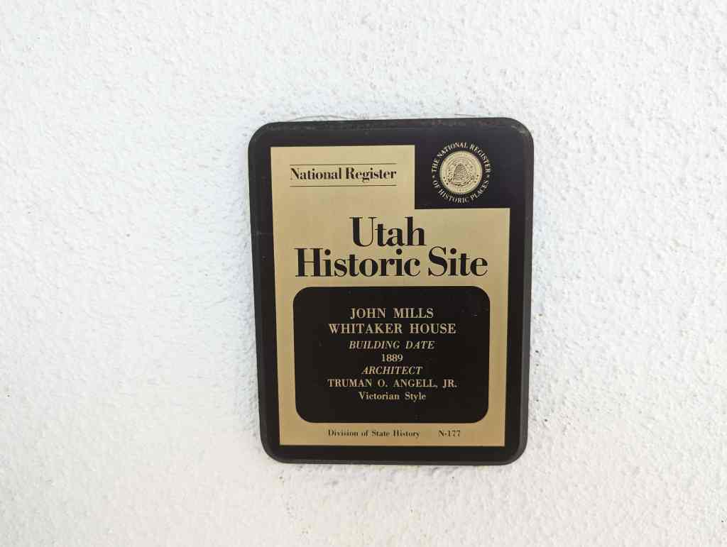
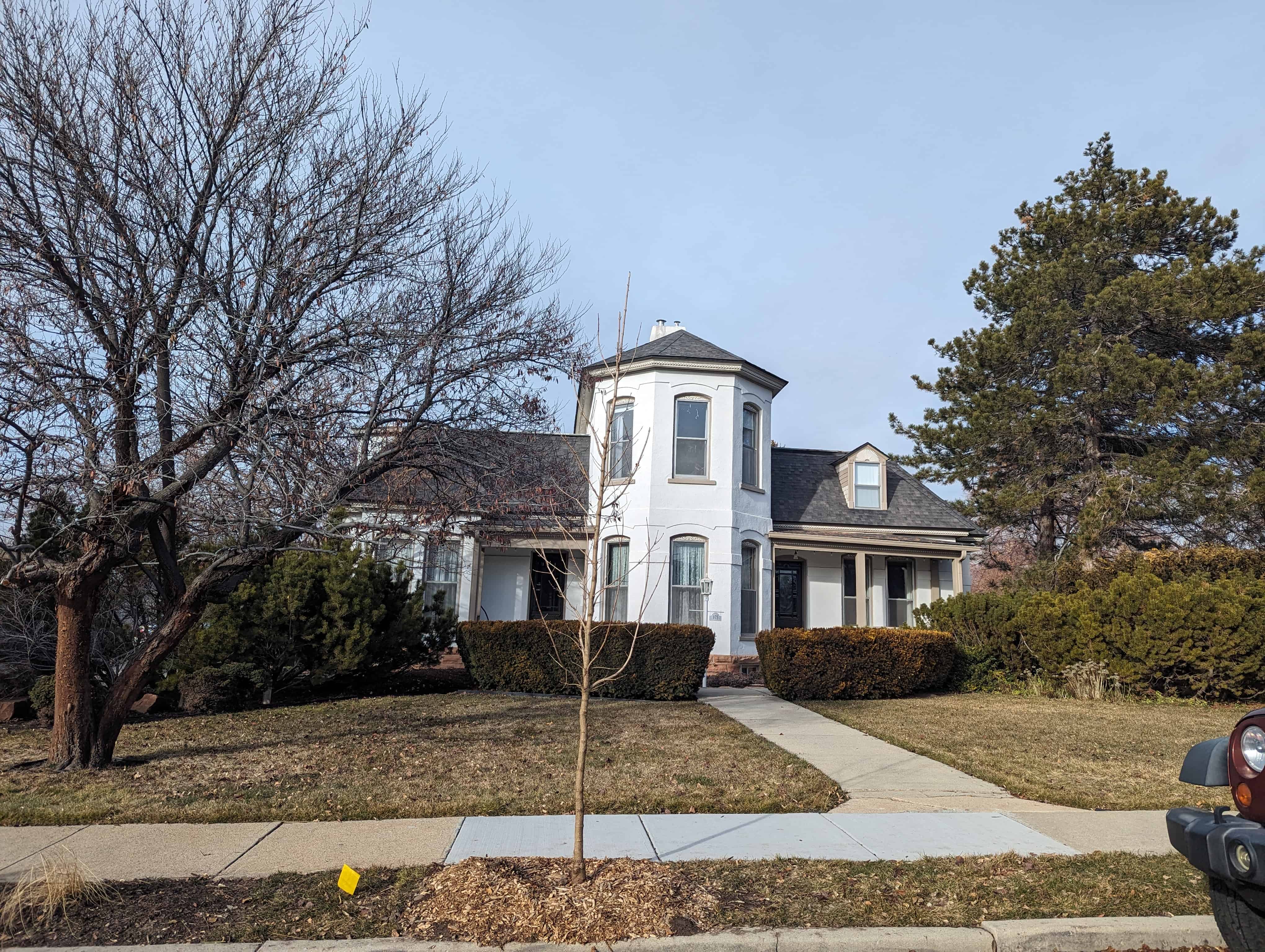
The John M. Whitaker House is significant for its association with its original owner, occupant and namesake, John Mills Whitaker, a man important for his contributions to his church, business, educational and political community. His voluminous journal and papers are a valuable local history resource.
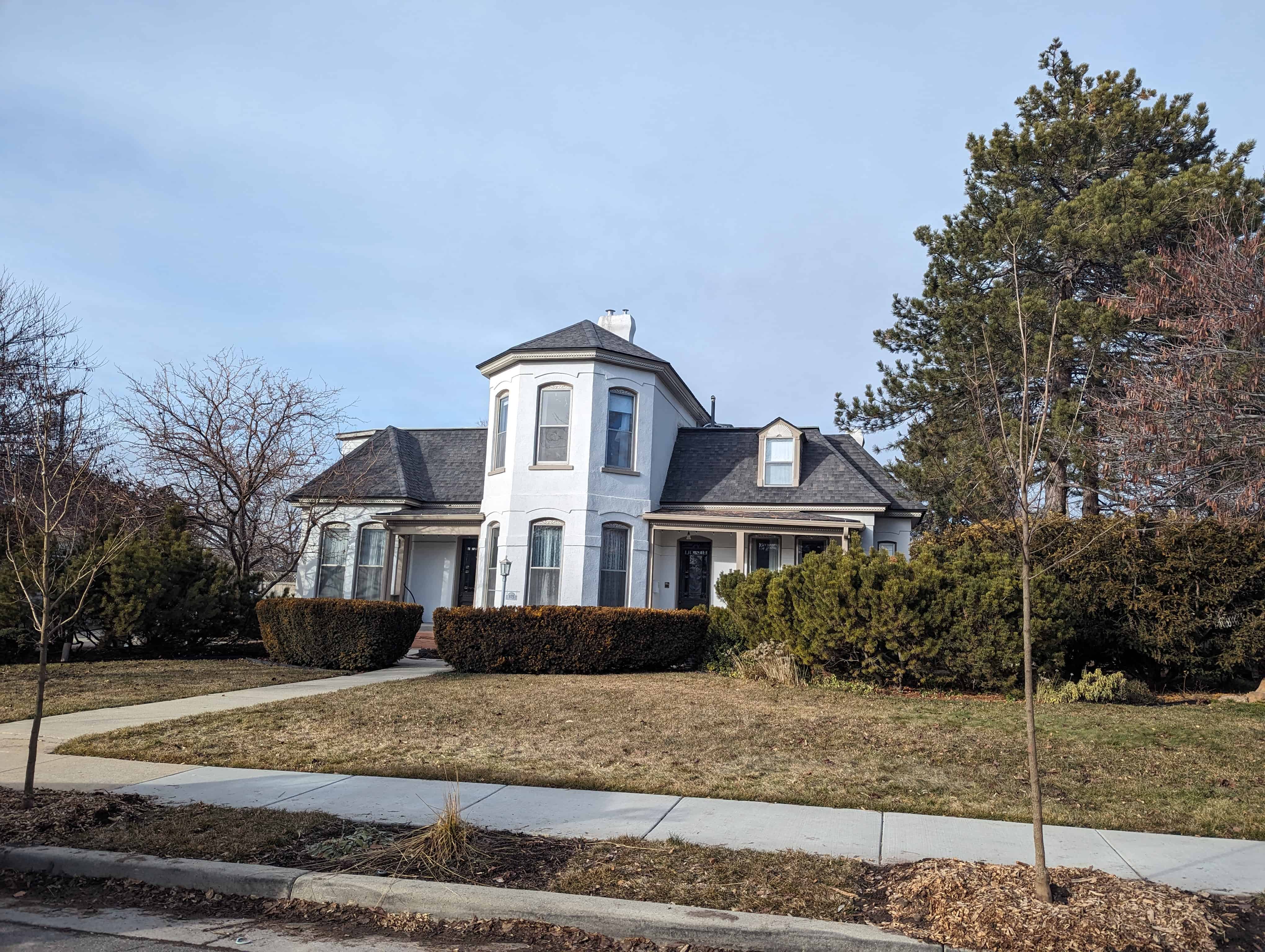
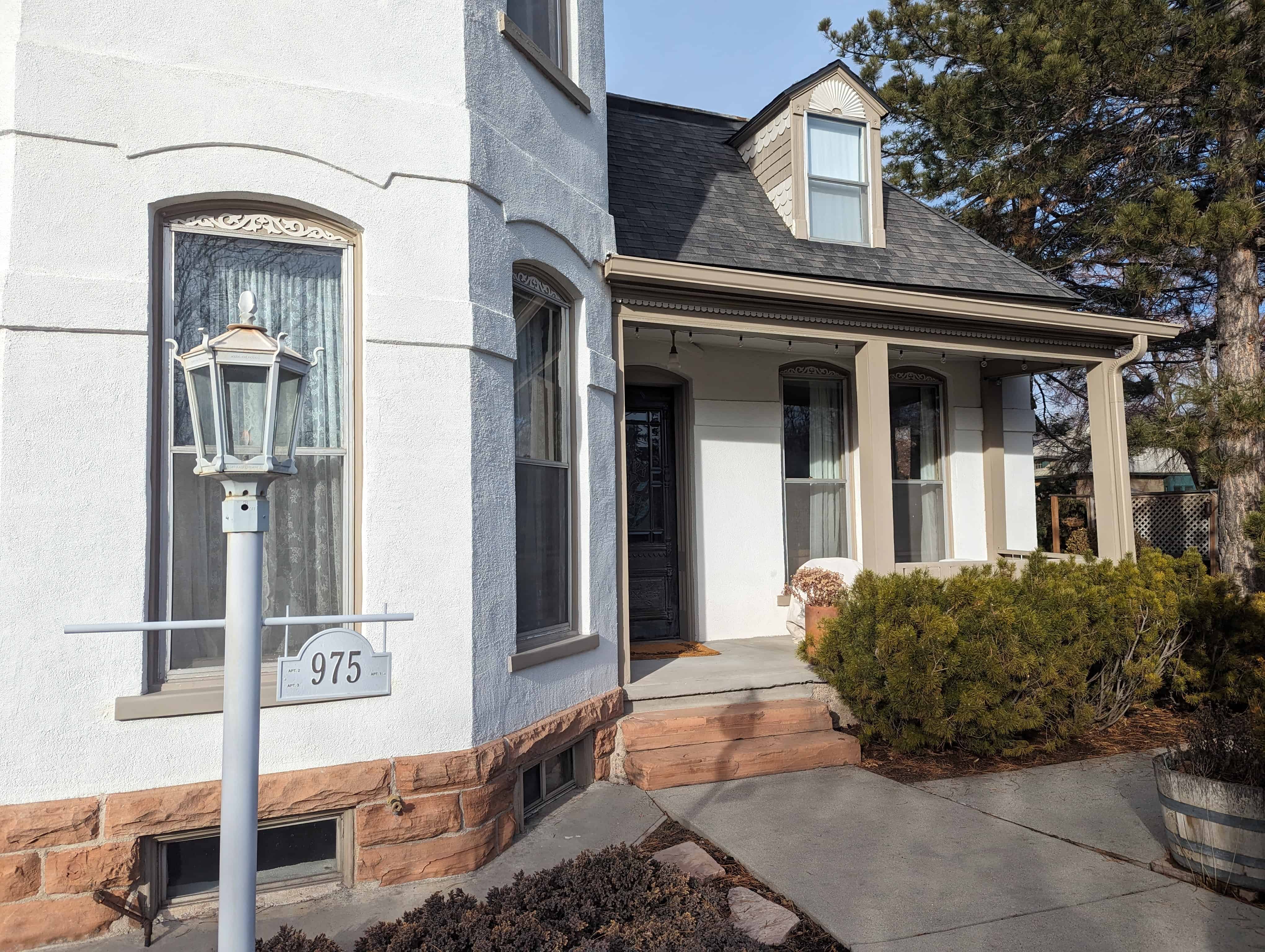
Built in 1889 and located at 975 East Garfield Avenue in Salt Lake City, Utah and added to the National Register of Historic Places (#78002684) on March 30, 1978. The text on this page is from the nomination form when it was added.
The John M. Whitaker House is a two-story building constructed of brick with stone trim in 1889. The residence follows the High Victorian Italianate style and is well preserved, excepting the stucco sheathing over the exterior brick–an alteration which conceals the original color and texture of much of the exterior. Inside, however, the house is very much intact.
Typical of Victorian era floorplans, the plan of the Whitaker House is irregular, yet it is almost symmetrical with both the east and west wings of the building being identical as to types and layouts of rooms. Each wing has separate front entries. The plan has all of the aspects of a two-family residence or perhaps a “polygamy house.” The central wing of the house has pent corners and is fully two stories tall, while the side wings are one-and-one-half stories in height.
The building has a hip roof and boxed and moulded cornice. The window bays are tall, segmentally arched and contain one-over-one operable sash windows. The wings have shallow, square bay windows. The foundation wall is sandstone. All major entries to the home are recessed and covered by wooden porches which feature carved wooden trim. The original landscaping is intact, the trees and shrubbery now being fully matured and very large. A photograph of the building taken shortly after construction shows the original appearance of the home and its yard.
Of its architectural features, the interior of the Whitaker House is most impressive Several fireplaces with ornamental wood mantels and front pieces, tile hearths, and stamped metal hoods are extant. A variety of Eastlake doors, as well as window and base trim are intact. The heavy Eastlake stair rails and balusters, high ceilings, wood floor and original hardware also remain in most areas of the building.
The original contract with T. O. and T. J. Angell, October 17, 1889, is extant and specified the “best of materials, Oregon pine studs, and maple, walnut or mahogany banister.” The contract also mentions a spring, a well, and plumbing and indicated “the house will be built at a cost of $4,575.”
John M. Whitaker was an active and prominent member of the Church of Jesus Christ of Latter-day Saints during its early years in the Salt Lake Valley. During his lifetime he saw the church emerge from the trying pre-manifesto days to its present condition. As a young man Whitaker knew intimately men whose lives reached back far beyond Civil War days. He was acquainted with Mormon Church President John Taylor and married his daughter Ida in 1886. He worked with John Young, son of Brigham Young, on some of the great railroad projects of Utah. Whitaker witnessed the dedication of the Salt Lake Temple and saw Utah enter into statehood. As one of the early residents of the Sugarhouse area, Whitaker developed what came to be known as the Verona Water System, the earliest supply of water in that location.
The papers of John M. Whitaker contain the many facets of his long life: missionary, bishop, patriarch, teacher and speaker in the L.D.S. Church as well as horticulturist, builder, educator, politician, businessman and diarist.
His business life included employment as the secretary of John W. Young and the building of the Salt Lake and Eastern Railway, manager of the Taylor Brothers Real Estate Company, assistant secretary and ticket and passenger agent of the Utah Light and Railway Company. He later became head of the office of the Utah Light and Railway Company (Utah Power and Light) , manager of the Deseret Employment Bureau, and Civic Employment Bureau and paymaster for the Civic Works Administration.
Whitaker was best known for his role in church activities and administration. He faithfully recorded what he saw and heard, and carefully preserved written information of all kinds. For fifty years he recorded for the press all the General Conferences of the Church of Jesus Christ of Latter-day Saints. He also initiated the tremendous growth of the seminary movement in the Mormon Church. His seminary teaching, the establishment of a Free Public Library which later became the Salt Lake Stake Library and his activities during the depression with unemployment in church and state marked the beginning of the ward, stake, and general welfare program of the Mormon Church.
During the polygamy persecutions when several church officials went into hiding Whitaker absorbed some of their responsibilities in their absence. This resulted in his work in the L.D.S. Church Historian’s Office and his long involvement recording and editing church history.
After the passage of the Edmunds-Tucker Law in 1887 the L.D.S. Church was disincorporated and Whitaker was out of work. He began employment with the Salt Lake Herald, the Cannon Brothers Real Estate Company, and gave private shorthand lessons, being an expert in that field.
In 1889 Whitaker was appointed to several prestigious offices in his church. It was also at this time that he became interested in politics. He worked for Senator Reed Smoot and made great efforts with lectures and press articles to defend B. H. Roberts in his fight to gain a seat in the United States Congress. He also defended and proselyted for Mormonism and became active in the prohibition movement, helping to organize the Utah Federation of Prohibition and Betterment League, later becoming its president in 1914. In addition, Whitaker was the first deputy treasurer of Salt Lake County. Whitaker’s last few years were concerned with seminary teaching, the initiation of the Church Welfare Plan and gardening. On April 2, 1960, John Mills Whitaker died at the age of 96.
The following chronology outlines the life and accomplishments of John M. Whitaker:
October 16, 1863. He was born at Centerville, Utah, the son of Thomas William Whitaker and Elizabeth (Oakden) Mills Whitaker. His youth was spent in Centerville and Ogden working with his father farming and in carpentry and building. At this time he began his study of Pittman shorthand. His first lessons were from his father.
December 17, 1879. He received a Territorial prize at the Deseret Agricultural and Manufacturing Society Fair for his wood carving of the Lord’s prayer. He was very proficient in carving and scroll work.
1883. He worked in a bank in Ogden for H. S. Young.
August, 1883. He went to Salt Lake City with his father to work in the building trades. He joined the Delta Phi Debating Society at the University of Deseret. He was made secretary. During the evenings he gave shorthand lessons to students. Also he started recording speeches, sermons and the conferences in the Tabernacle, which activities he continued throughout most of his life.
November 7, 1882. He met Ida Taylor, daughter of John Taylor, president of the L.D.S. Church, and Mary Oakley Taylor.
January, 1884. He registered at the University of Deseret as a Normal student. He earned money by giving shorthand lessons, recording sermons and speeches. He was also employed on a part time basis as instructor in phonography (phonetics, shorthand, typewriting and commercial letter writing). He also helped his father. He attended the 14th Ward where he met many Church leaders, contacts which were of benefit to him later.
July 7, 1884. Franklin D. Richards, L.D.S. Church Historian, offered him a part time job which he accepted. During the time of the polygamous persecutions when Richards had to be away, Whitaker was responsible for all the office business.
April 28, 1886. His father, Thomas W. Whitaker, died suddenly of a heart attack in Salt Lake City.
June, 1886. He received his two-year Normal degree.
September 22, 1886. He married Ida Taylor. They lived at the Gardo House for a time-while President Taylor was in hiding during the time of polygamy period.
February 23, 1887. He began efforts to establish a Free Library and Reading Room in the Salt Lake Stake.
July 23, 1887. John and Ida’s first child was born. She was named Ida Taylor Whitaker.
July 25, 1887. President John Taylor died while still in hiding over polygamy.
The Church offices closed because of federal pressures. The L.D.S. Church was disincorporated as a result of the Edmunds-Tucker Law passed March 1887. Whitaker was out of work. He was offered part time employment for the Salt Lake Herald, which position he accepted. He also worked for the Cannon Brothers Real Estate Company and other establishments. He continued to give private shorthand classes. At this time he became actively interested in politics. Through his efforts the Salt Lake Stake Library was established.
February 29, 1888. He was asked by John W. Young, owner and manager of the Salt Lake and Fort Douglas Railway to work for him. He became his private secretary and was managing secretary for the railroad. August 30, 1888. He became the purchasing agent for the Salt Lake and Eastern Railway also. This necessitated giving up the University and other work except some reporting for F. D. Richards. September 3, 1888 he was put in charge of the new offices, and on September 22 was made director. October 3 he was in charge of all affairs of John W. Young while Young was in the East.
September 22, 1888. His daughter Mary Taylor was born. She died November 28, 1888.
January 24, 1889. He was called to New York by Young to assist him there.
June 11, 1889. He purchased an acre of ground in Sugarhouse area.
June 24, 1889. He assisted Young in the organization of the Utah-Western Railway Company. He became one of the directors and stockholders.
July 11, 1889. He became secretary and general treasurer of the First Council of Seventy of the Church of Jesus Christ of Latter-day Saints. He was also a member and the secretary of the Sunday School Union Board and secretary to the General Superintendency of the Sunday Schools.
1889. He continued private shorthand classes and wrote out blessings of missionaries for the extra income. During August he taught a class at the University of Utah. He taught the first Commercial course given at the University of Utah.
1889. He was assistant secretary of the Bullion Dust Mining Company.
September, 1889. He turned over to others the work of the Free Library.
October 17, 1889. He let the contract for the building of his home at 975 Garfield Ave.
January 5, 1890. His daughter Elizabeth Taylor was born.
September, 1890. The family moved to their new home in Sugerhouse Ward.
1890. He became very active in promoting learning among the young people. He was soon elected a trustee of the Twenty-ninth School District.
August 18, 1891. His daughter Marguerite Taylor was born.
1891. He was still actively interested in politics. He also recorded many speeches of visiting celebrities.
June 3, 1893. He received his teaching certificate from the University of Utah.
November 6, 1892. His son John Taylor was born.
1895. He was one of the reporters for the Constitutional Convention. He voted “Yes” for Utah to become a state.
February 23, 1896. His son Leon Taylor was born. Died, April 13 of whooping cough.
November, 1896. He cast his first vote for the President of the United States.
May 5, 1897. His daughter Janette Taylor was born.
August 18, 1897. He was called on a mission to the Eastern States Mission. He left December 3, 1897.
1898. He was in charge of the elders of New Jersey. He lectured, wrote press articles and his first pamphlet, “The Plan of Salvation.” May 1898. He was appointed president of the New England Conference. He organized the first L.D.S. Sunday School in Providence, Rhode Island.
May, 1899. William H. Smart, president of the Eastern States Mission, called John Whitaker to Boston to act as his assistant. His assignment was to systematize the Mission records, write histories of the conferences and also a general history of the Mission. During all this time he made great efforts with lectures and press articles to defend B. H. Roberts in his fight to gain his seat in Congress. He also did the same in defending and proselyting for Mormonism.
January 20, 1900. He was released from his mission after 25 months in the field.
November 24, 1900. His son Eugene Taylor was born.
February 1900. He was appointed second counselor to the bishop of Sugarhouse Ward. January 1902. He was appointed first counselor.
February 7, 1901. His son John T. Died of diphtheria.
1902. He became the first deputy treasurer of Salt Lake County.
1903. He was a worker for Reed Smoot, Senator. He was one of the committee to go to Washington to plead the case.
July 26, 1904. His son Edison was born.
January 1905. He was made bishop of Sugarhouse Ward.
March, 1905. He became assistant secretary and ticket and passenger agent of the new Consolidated Light and Railway Company. Later he became head of the office of the Utah Light and Railway (Utah Power and Light Company).
February 9, 1907. He resigned this position to become manager of the Taylor Brothers Real Estate Company. In 1908, Taylor brothers Real Estate was agent in this area for the King Hill Irrigation Project, King Hill, Idaho. Whitaker was actively involved in its preliminary promotion. He and members of the family bought into it.
May 1911. He first expressed his interest in prohibition. He became active in the movement and helped organize the Utah Federation of Prohibition and Betterment League. In 1914 he became its first president.
March 1914. He was released as bishop of the Sugarhouse Ward when it was divided and reorganized. He was selected to be a patriarch.
1915. He was appointed by Frank Y. Taylor as the instructor for the L.D.S. Granite School Seminary. He reorganized the whole curriculum and procedure. With Adam S. Bennion, superintendent of Church Education, George H. Brimhall, president of B.Y.U., and others, he helped develop the church seminary system and curriculum.
April 1917. He proposed having the Seminary students speak in the wards, which activity has continued.
June 10, 1919. He received his Bachelor of Science in Education and his High School Life Diploma from the University of Utah. He continued taking courses in evolution, psychology, science and modern thought under visiting professors.
July 1920. As chairman he conducted the Lecture Program for Seminary Teachers at the B.Y.U. Aspen Grove Summer School. He delivered many of the lectures himself.
June 1921. He was again responsible for the lecture program on “Doctrine of the Church” at B.Y.U. Summer School.
January 15, 1925. He was made chairman of the new Editing Committee on Church History and Doctrines with Sidney B. Sperry, David A. Broadbent, and Enoch Jorgensen.
July-August, 1927. He taught the course “Science and Religion” at B.Y.U. Aspen Grove Summer School.
June 1929. At age 65 he retired from seminary teaching.
November 1927. The family moved from the old home at 975 Gargield where they had lived for 27 years to the newly completed home at 1536 South 13th East.
December 13, 1929. He became the manager of the Deseret Employment Bureau. He immediately put into it the same enthusiasm, systematizing efforts, innovations and hard work as in all his endeavors.
Fall of 1930. He also managed the newly created Civic Employment Bureau. It closed in the spring of 1931, reopened in the fall of 1931, and closed again the next spring of 1932.
August 1932. The Deseret Employment Bureau was placed under the Presiding Bishop’s Office. He was designated as “contact officer.” He also received the tithing in produce under David F. Smith, manager of Growers’ Exchange. Continued through 1936.
1933. He was paymaster for Civic Works Administration. He also taught some seminary classes. 1936. The Welfare Plan of the Church of Jesus Christ of Latter-day Saints was initiated. Whitaker was invited to meet and help in its organization and development. Much of his past work became a basis for its development.
1937. His mother, Elizabeth Mills Whitaker, died in Centerville, at the age of 98 years
1939. The Federal reform program was becoming a program of recovery. This brought about the end of the work with the Presiding Bishop’s Office.
June 1942. He and Ida became members of the University of Utah Emeritus Club. June 7, 1943. He was made its president.
May 22, 1946. On this date occurred the death of his wife, Ida Oakley Whitaker, at their home. She was 86 years old, the last surviving daughter of President John Taylor. He lived alone until 1954. He worked in his garden, with his sons, attended church, did ward teaching, gave blessings, had fireside meetings in his home. He began to organize and write his transcript journal from his many notes, letters, and diaries.
1951. He made a trip to the H. E. Huntington Library at San Marino, California, to see Leslie E. Bliss who was interested in the Whitaker journal. He made arrangements for them to make photostatic copies.
1954. His daughter Bessie and husband Nelson G. Hunt moved in with him. Mr. Hunt died soon after.
1958. He made arrangements with Mr. L. H. Kirkpatrick to send his library and collection of papers, letters, diaries, etc., to the University of Utah Library. Some were turned over to them in 1959 and some were to be given later. The last were received by the Library in 1969.
July 29, 1959. He made his last journal entry.
April 2, 1960. He gave his last blessing. Three hours later he died at his home on 13th East, age 96 years 6 months.
Whitaker’s house was designed by Truman O. Angell, Jr. and built by the Angell Brothers. Angell is best known as architect of the Logan Temple and Temple ton Building The Whitaker House, built in 1889, is High Victorian Italianate in style.
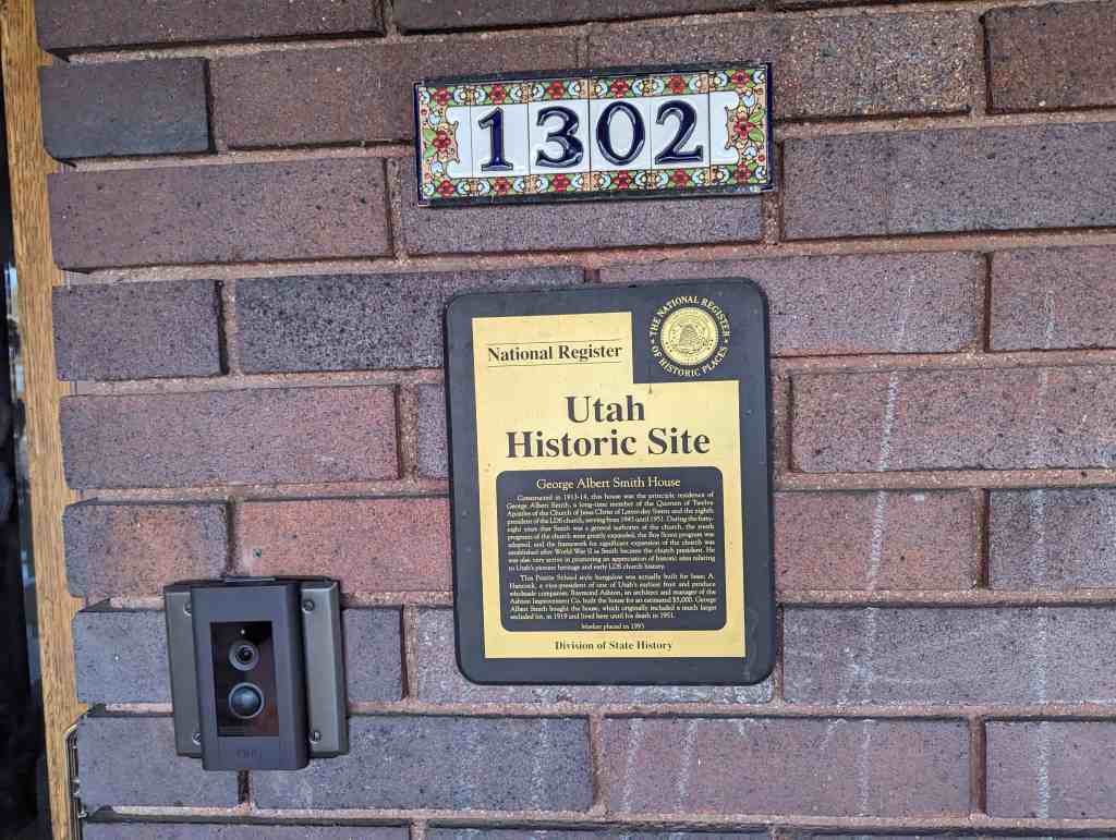
Constructed in 1913-14, this house was the principle residence of George Albert Smith, a long-time member of the Quorum of Twelve Apostles of the Church of Jesus Christ of Latter-day Saints and the eighth president of the LDS church, serving from 1945 until 1951. During the forty-eight years that Smith was a general authority of the church, the youth programs of the church were greatly expanded, the Boy Scout program was adopted, and the framework for significant expansion of the church was established after World War II as Smith became the church president. He was also very active in promoting an appreciation of historic sites relating to Utah’s pioneer heritage and early LDS church history.
This Prairie School style bungalow was actually built for Isaac A. Hancock, a vice-president of one of Utah’s earliest fruit and produce wholesale companies. Raymond Ashton, an architect and manager of the Ashton Improvement Co. built the house for an estimated $5,000, George Albert Smith bought the house, which originally included a much larger secluded lot, in 1919 and lived here until his death in 1951.
Located at 1302 East Yale Avenue in the Yalecrest Neighborhood and the Yalecrest Historic District in Salt Lake City, Utah and added to the National Register of Historic Places (#93000066) on March 12, 1993. The text above is from the plaque on the home, the text below is from the nomination form for the National Register.
Constructed in 1913-14, this house is significant for its association with George Albert Smith, long-time apostle of the Church of Jesus Christ of Latter-day Saints (LDS or Mormon church) and president of the church from 1945 until 1951. Smith bought the house in 1919 and remained here until his death in 1951. Though he lived in other residences prior to this one, this was his principal residence and the one most closely associated with his career as an important religious leader. As eighth president of the LDS church, George Albert Smith ranks as an exceptionally significant figure, thereby overriding the requirement that properties achieve their significance at least fifty years ago.
The George Albert Smith House was actually constructed for Isaac A. Hancock, vice-president of Hancock Brothers Fruit Company, which was one of the earliest wholesale fruit and produce companies in Utah. Hancock obtained a building permit for the house on November 26, 1913. The estimated cost of construction was $5,000, and the builder was listed as Raymond Ashton. Mr. Hancock lived in the house until 1919, when he sold it to George Albert and Lucy Emily Smith and moved up the street to 1340 Yale Avenue. Raymond Ashton was the manager of Ashton Improvement Company and was also an architect, suggesting that he may have been involved in the design of the house. Raymond Ashton was also associated with Edward M. Ashton (his brother) and Edward M. Jenkins, developers of Yale Park subdivision and other east side, Salt Lake residential areas.
At the time the Smiths purchased this house, George Albert was vice-president of Utah Savings and Trust Company and a member of the Quorum of the Twelve Apostles in the Church of Jesus Christ of Latter-day Saints. The Quorum of the Twelve is the governing body of the church directly under the president and his councilors. Members of the Quorum and other top church officials, known as general authorities, held positions with church-owned companies as a means of financial support; their primary occupation, however, was church work. George Albert Smith had been appointed to serve as an apostle in 1903 at the relatively young age of 33. Both his father and grandfather had also served as apostles. His occupation prior to his call to the apostleship was as receiver for the Land Office of Utah, having been appointed by U.S. President William McKinley in 1897 and reappointed by Theodore Roosevelt in 1902. Smith served as an apostle in the LDS church until his selection as eighth president of the church on May 21, 1945, after the death of president Heber J. Grant. He was 75 years old at the time. He remained president of the church until his death on April 4, 1951.
George Albert Smith’s career as an apostle and president of the LDS church spanned 48 years and was marked by several significant achievements. He was particularly active in programs for the youth of the church. He was a member of the general board of the church’s Young Men’s Mutual Improvement Association (YMMIA) from 1904 until 1921, then served as general superintendent of that organization from 1921 to 1935. In that role he was influential in setting policies, establishing programs, and directing youth activities throughout the church. Smith was impressed with the Boy Scout program and recommended its incorporation into the YMMIA program after it was introduced in the United States in 1910. The church adopted the program with such enthusiasm that Utah and the church emerged as world leaders in the percentage of boys enrolled in scouting programs. Smith directed the scouting program in the church and in 1931 was appointed to the advisory board of the National Council of Boy Scouts of America. In 1932 he was awarded the Silver Beaver, and in 1934 the Silver Buffalo, two of scouting 1 s highest awards.
Smith was also very active in promoting awareness and appreciation for historic sites related to church and Utah pioneer history. He was instrumental in acquiring property and erecting a monument in upstate New York in recognition of church founder Joseph Smith and in 1937 organized the Utah Pioneer Trails and Landmarks Association. That organization erected hundreds of historic monuments are markers along the Mormon Trail (from Nauvoo, Illinois, to Utah) and throughout the west, including the “This Is The Place” monument at the mouth of Emigration Canyon east of Salt Lake City, which was erected in 1947 on the 100-year anniversary of the arrival of the Mormon pioneers to the Salt Lake Valley.
During George Albert Smith’s tenure as church president the church began expanding its presence in the United States and throughout the world. His appointment as president in 1945 coincided with the end of World War II, which afforded new opportunities for church expansion. The church’s missionary program was revitalized as the number of missionaries rose to over 5,000, an unprecedented high. There was a marked increase in the number of wards (congregations) and stakes (groups of congregations) organized, some 200 new meetinghouses were built, new hospitals were constructed and old ones enlarged, and a new temple was completed in Idaho Falls, Idaho. Growth of the church in subsequent decades would be even more dramatic, but the pattern for much of that later growth was established in the years after World War II while George Albert Smith was president.
When the Smiths purchased the home from Isaac Hancock in 1919, they were attracted by its location and large lot. The house is situated on the east bench of Salt Lake City, a new and desirable residential neighborhood at the time. They had been living downtown near Temple Square (21 N. West Temple, now demolished), a neighborhood that was rapidly losing its residential character. An especially attractive feature of the new house and lot was Red Butte Creek, which ran through the back of the property. The creek was far below the level of the street and house, and offered a secluded natural retreat for the family. The large size of the property–large enough for three additional houses added to the sense of seclusion that the Smiths enjoyed. They envisioned a family compound, with all three of their children constructing houses on the property. This dream was only partially realized. The two married daughters built homes nearby, one to the south across the creek and the other to the east, but their son Albert chose to remain in the East after completing his schooling at Harvard. The lot earmarked for his home, directly east of the parents’, was instead used as a garden area for outdoor entertaining. One notable event celebrated in the Smith’s yard was a dinner party for 400 guests, including the governors of forty-six states, their wives, and other dignitaries on July 15, 1947. This was one of the key events in the pioneer centennial celebration that culminated on July 24, 1947.
After George Albert Smith’s death in 1951, the house was held in trust by his family until 1953, when it was sold to Warwick Lamoreaux, an attorney. During Lamoreaux’s ownership, a number of minor changes were made to the house and a duplex was built next door in the garden area. Two other houses were also built on the property down near the creek; these are now separate properties. The current owners of the Smith House, Dennis M. Greenlee and Diana G. Pounder, purchased it in 1989 and have returned much of the house to its original condition.
Description:
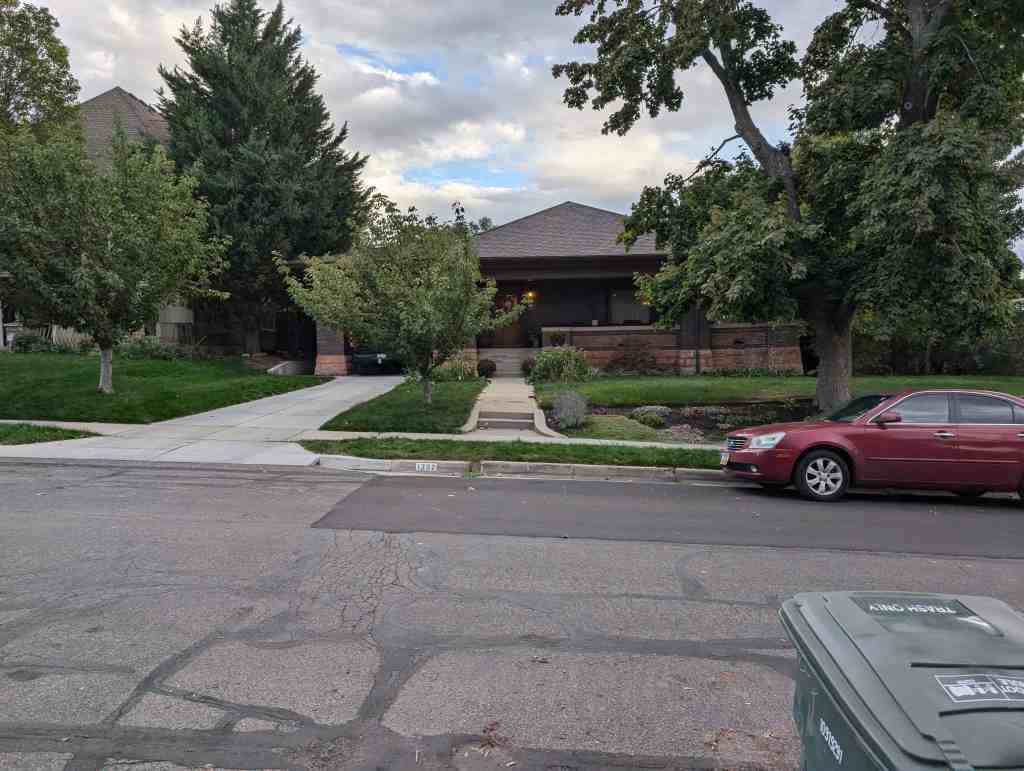
The George Albert Smith House, built in 1913, is a one-story brick bungalow with a hip roof, sandstone foundation, and Prairie School stylistic influences. No major alterations have been made to the house, though a few minor changes have been made on both the exterior and interior. Overall, however, it retains a high degree of its original integrity.
The house is slightly elevated above and east of 1300 East Street and is on the corner lot on the south side of Yale Avenue. The house is approximately 41 feet wide (plus the 13 foot wide porte-cochere) and 70 feet long with the more narrow front end facing Yale Avenue. The original property included both the lot directly east of the house as well as the lot directly south of the house adjoining Red Butte Creek. The side lot was used as a rose garden and the back lot was a terraced wooded area down to the creek. The east lot now has a brick duplex on it, and the south lot has two more contemporary residences overlooking the creek. These are no longer part of the Smith House property and are not included in the nomination.
Typical of Prairie School bungalows, the house has a low, horizontal emphasis. This horizontality is created by the low-pitched hip roof with wide eaves, the fullwidth, wrap-around front porch with a brick railing wall, and the porch cochere which extends the overall width of the house to the east. The house appears very heavy and large (a total of over 4000 square feet on the main floor and basement combined). It rests on a large rusticated sandstone foundation, and the exterior walls are a very dark reddish-brown fired brick, still in very good condition. The use of these natural materials and earthen colors are typical of the Prairie style home. These brick walls support a low hip roof which overhangs the walls by nearly two feet, again typical of the Prairie style homes. On the east side of the house is a porte-cochere with steps leading to the porch and front entrance. The porch extends across the entire front of the house and about a third of the way down the west side. The porte-cochere and porch are supported by heavy brick columns.
On either side of the front door and on the columns by the stairs are light fixtures with a hand-crafted appearance, similar to those found in Greene and Greene’s Gamble House in Pasadena, CA. The fixtures flanking the door have simple red and green stained glass flower figures in them, whereas those mounted on the columns of the porte-cochere have no stained glass work. The front door and the side door to the dining room (from the porch) are heavy oak doors with Arts and Crafts type brass hardware and beveled glass inserts on the top half.
There are a variety of window types used in the house. Many of the original windows are casement type, the most interesting of which are the stained glass windows on either end of the living room mantel and in the front bath (formerly a part of the entry hall). These stained glass windows have a more curvilinear and organic design than is typical of the Prairie School style, which tend to be geometric patterns, and are highlighted with green and gold colors. The bookcases flanking the fireplace are also encased with leaded glass doors which have a more elaborate geometric pattern. There are two large picture windows, one each in the living room and dining room. The east side bedrooms and the kitchen contain standard single hung windows, whereas the back of the house contain large casement type windows with small panes in them. Some are hinged on the top, swing into the room and hooking on the ceiling for a “porch-like” effect. (The exterior storm windows were added in recent years.) A shed-roofed carport extension has been added on the rear of the porte-cochere (probably post-1960s), but it is barely visible from the front of the house.
The large living and dining areas are open to each other with only a third-height wall separating the two spaces midway down on the west side of the room (see floor plan). Markings on the original quarter-sawn oak floors and salvaged red gum woodwork found in the attic suggest that the two rooms were formerly separated by built-in bookcases enclosed with leaded glass doors on either side of the living/dining dividing wall. George Albert Smith’s granddaughter, Margaret Hatch, reports that the living and dining areas were also separated by full-length folding glass doors that stretched between the built-in bookcases.
The dining area also originally had a built-in buffet cabinet on its south wall with a pass-through to the kitchen. Other gumwood detail including a large plate rail about two-thirds up the wall height were removed during Mr. Lamoreaux’s occupancy (post-1953). These former and present wood accents would have been typical of a Prairie bungalow home. Much of the original woodwork has been painted, but the entry hall “divider,” the fireplace mantel, stained glass windows, bookcase leaded glass doors, and the doors in the living/dining area are refinished red gum wood. The entry/living/dining floors are quarter-sawn oak. Other floors in the house are currently carpeted, but have cedar floors beneath them. The entry hall and dining room also have matching copper-colored chandeliers with a hand-crafted geometric appearance.
The kitchen is immediately south of the dining area and is appointed with almost all of the original cabinet work, including the original built-in ironing board and potato bin. Only slight alterations have been done to accommodate more modern appliances. The flow or movement between the kitchen and dining room was probably made easier by use of the original pass-through to the built-in dining room cabinet, though the pass-through is closed off now.
There is a clear distinction in the floor plan between public and private space. The living, dining, and kitchen areas are on the west side of the house nearer 1300 East Street, whereas the bedrooms and baths are on the more private east side of the house. The bedrooms are a comfortable size and have unusual built-in closets/cupboards with glass front doors, all of which are original to the house. The hallway also has similar built-in cupboards. The walls of the bedrooms as well as all other rooms are the original plaster, all of which is in very good condition. The main bath is appointed with most of its original fixtures, including a claw foot tub, built-in vanity cabinet, and white hexagonal ceramic floor tiles.
The home is well-built and well-preserved, with only minor changes in its design. The house is still heated with the original furnace (converted to gas) and original steam heated radiators. The only major alterations have been in the basement, where the floor plan has been altered to accommodate a basement apartment.