• About JacobBarlow.com
  • Cemeteries in Utah
  • D.U.P. Markers
  • Doors
  • Exploring Utah Email List
  • Geocaching
  • Historic Marker Map
  • Links
  • Movie/TV Show Filming Locations
  • Oldest in Utah
  • Other Travels
  • Photos Then and Now
  • S.U.P. Markers
  • U.P.T.L.A. Markers
  • Utah Cities and Places.
  • Utah Homes for Sale
  • Utah Treasure Hunt

JacobBarlow.com

~ Exploring with Jacob Barlow

JacobBarlow.com

Tag Archives: utah

Early Settlers of Bluffdale

10 Tuesday Jun 2014

Posted by Jacob Barlow in Uncategorized

≈ 2 Comments

Tags

Bluffdale, DUP, historic, Salt Lake County, utah

picture6aug07-034

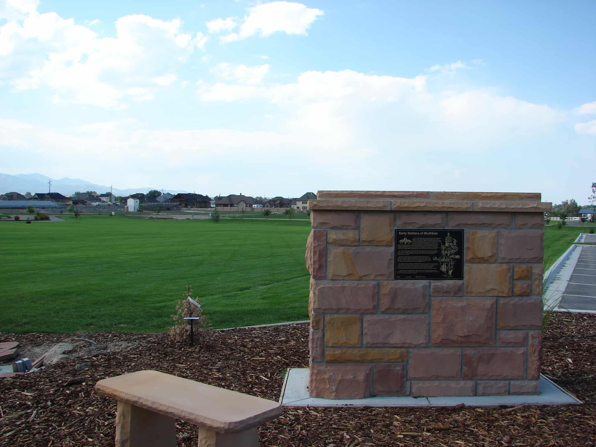
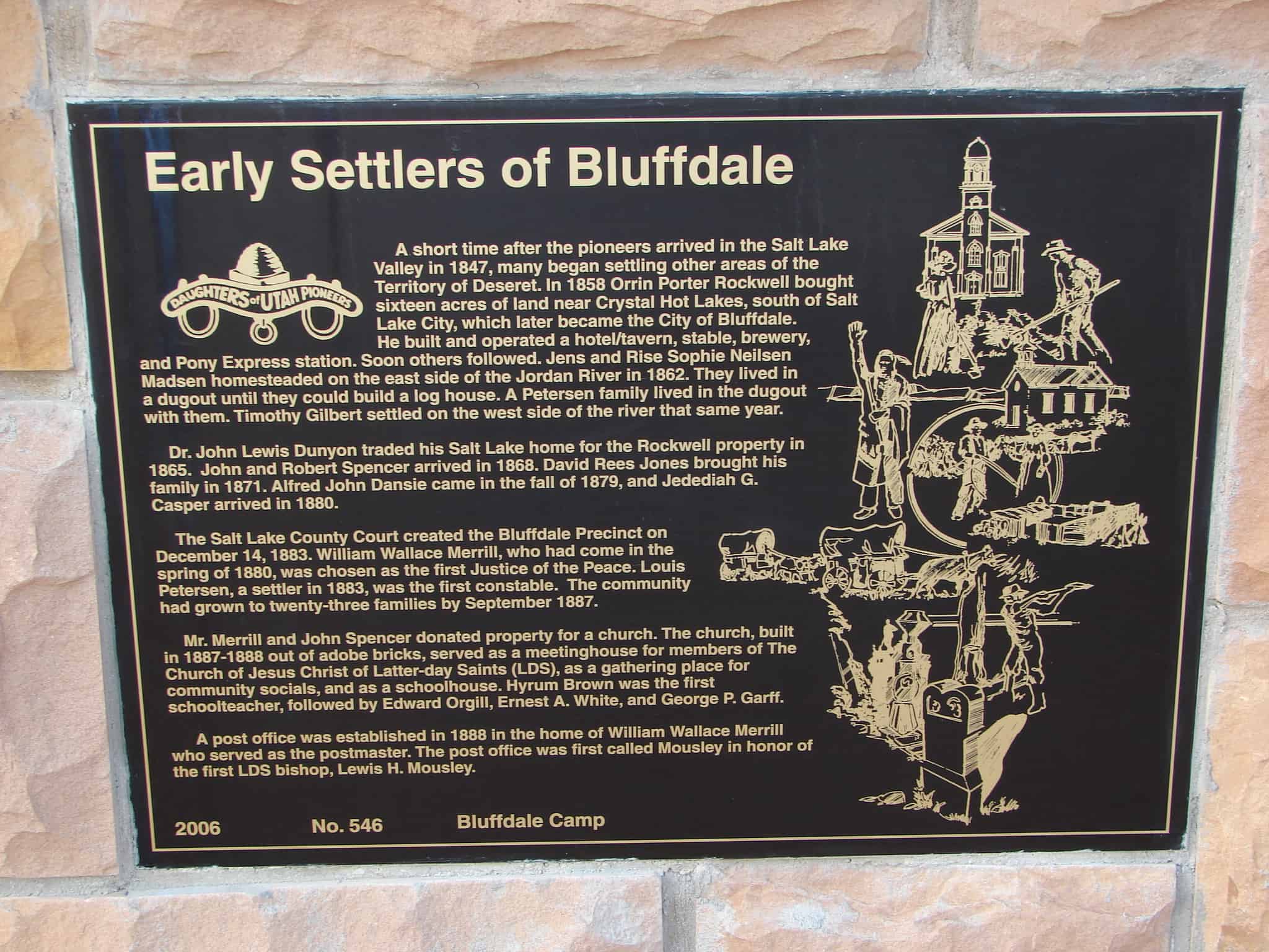
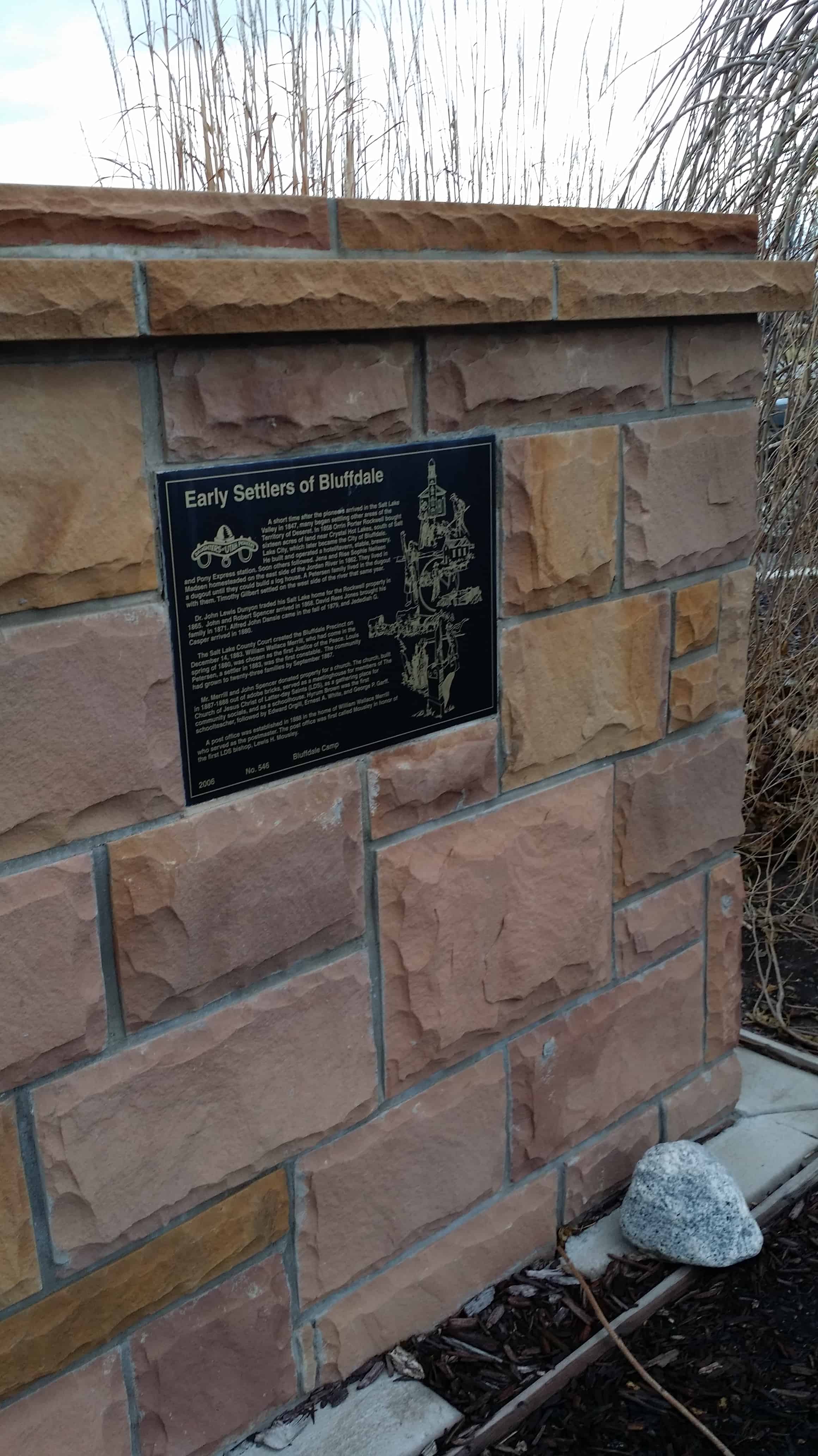
A short time after the pioneers arrived in the Salt Lake Valley in 1847, many began settling other areas of the Territory of Deseret. In 1858 Orrin Porter Rockwell bought sixteen acres of land near Crystal Hot Springs, south of Salt Lake City, which later became the City of Bluffdale. He built and operated a hotel/tavern, stable, brewery, and Pony Express station. Soon others followed. Jens and Rise Sophie Neilson Madsen homesteaded on the east side of the Jordan River in 1862. They lived in a dugout until they could build a log house. A Petersen family lived in the dugout with them. Timothy Gilbert settled on the west side of the river that same year.

Dr. John Lewis Dunyon traded his Salt Lake home for the Rockwell property in 1865. John and Robert Spencer arrived in 1868. David Rees Jones brought his family in 1871. Alfred John Dansie came in the fall of 1879, and Jedediah G. Casper arrived in 1880.

The Salt Lake County Court created the Bluffdale Precinct on December 14, 1883. Willam Wallace Merrill, who had come in the spring of 1880, was chosen as the first Justice of the Peace. Louis Petersen, a settler in 1883, was the first constable. The community had grown to twenty-three families by September 1887.

Mr. Merrill and John Spencer donated property for a church. The church, built in 1887-1888 out of adobe bricks, served as a meetinghouse for members of The Church of Jesus Christ of Latter-day Saints (LDS), as a gathering place for community socials, and as a schoolhouse. Hyrum Brown was the first schoolteacher, followed by Edward Orgill, Ernest A. White, and George P. Garff.

A post office was established in 18888 in the home of William Wallace Merrill who served as the postmaster. The post office was first called Mousley in honor of the first LDS bishop, Lewis H. Mousley.

picture6aug07-033

ingress_20141214_163613_0

Check out all of the historic markers placed by the Daughters of Utah Pioneers at JacobBarlow.com/dup

Daniel Wood Cemetery

10 Tuesday Jun 2014

Posted by Jacob Barlow in Uncategorized

≈ 2 Comments

Tags

Bountiful, Davis County, DUP, historic, utah

picture7sep07-191

This small private cemetery, once known as Nathan’s Burial Ground, is the final resting place of the early pioneer settler Daniel Wood and many of his relatives. It is one of the oldest burial plots in Davis County.

Daniel Wood emigrated from Nauvoo, Illinois, to to the Salt Lake Valley. He arrived on July 23, 1848, with his wives, Mary Snider Wood and Peninah Shropshire Cotton Wood, and their families. They traveled north to Sessions Settlement, which was later called North Canyon Ward and is now Bountiful. Daniel moved from Bountiful to what is now Woods Cross and filed on 120 acres of land. He planted fruit trees on five acres of the southeast section of his farm.

Two of Daniel’s grandchildren, Elizabeth Yancy, and Parley P. Yancy, died soon after birth in 1857 and were buried beneath an apple tree. When Nathan Wood, son of Daniel and Emma E. Crow Wood, fell from a farm wagon and was killed, August 17, 1858, a three-rod square of land was marked off and dedicated by Daniel as a final resting place for his family. Nathan was buried in the new cemetery near the raves of the two babies.

Over the years, other family members died and were buried in the Daniel Wood Cemetery. Three adopted orphan Native American died during the year 1860-1861. Diphtheria, accidents and health problems caused other deaths. John Dutch, a hired man who lived with the Wood family for about five years, died and was buried in the northwest part of the cemetery.

Daniel Wood lived until his 92nd year and died April 25, 1892. He was buried beside his first wife, Mary, in a place he had marked for himself in his family cemetery. In the spring of 1893, his son, Joseph Cotton Wood, designated and built an iron fence around the family plot.

Now buried in the Daniel Wood cemetery are Daniel and six of his wives, seven children, ten grandchildren, one great-grandson, two wives of his son John, three Native American children, hired man John Dutch and one stepson – a total of thirty-two graves.

picture7sep07-190

Check out all of the historic markers placed by the Daughters of Utah Pioneers at JacobBarlow.com/dup

West Layton Meeting House

10 Tuesday Jun 2014

Posted by Jacob Barlow in Uncategorized

≈ Leave a comment

Tags

Davis County, DUP, historic, Layton, utah

As pioneer settlers spread out onto the rangelands of Kaysville along the two branches of Kays Creek, those in the north, who made their living dry farming and stock raising, separated from Kaysville to form their own town. It was named Layton, after Christopher Layton. A U.S. post office opened in 1886.

Layton members of The Church of Jesus Christ of Latter-day Saints attended meeting together. Those families living in the west fields were divided from those in the eastern part in 1895 and became known as the West Layton Ward.

Church meetings for the West Layton congregation were first held in a small brick schoolhouse that had been built in 1892.

Charles A. Layton later donated an acre of property east of this monument where a brick meetinghouses was built in 1897. It was financed exclusively by members and was known as a “Tithing” Ward. The building was dedicated March 31, 1901, by Joseph F. Smith.

The 56′ x 120′ structure was erected on a foundation constructed of rock and plaster. The cathedral-type ceiling had joists about twelve feet long at the apex of the roof. The walls were four bricks thick. Three of the layers were adobe bricks mixed, molded, and sunbaked at the construction site by young men.

Commercially kiln-fired brick covered the adobes. The chapel was divided into nine classrooms by heavy green curtains suspended on steel wire. The steeple had a bell tower, but no bell was ever hung there.

Over the years other rooms were added. The meetinghouse served as the community social center, hosting dances, cultural productions, and other activities until it was torn down in 1971.

Daugters of Utah Pioneers historic marker #539 located at 2120 West Gentile Street in Layton, Utah – Also located here is the Bur Oak Tree.

  • D.U.P. Historic Markers

picture31march08-021
picture31march08-020

Pettyville Pioneers

10 Tuesday Jun 2014

Posted by Jacob Barlow in Uncategorized

≈ 1 Comment

Tags

DUP, historic, Sanpete County, Sterling, utah

  • Image

In this cemetery are the remains of many of the settlers of the town of Pettyville. In 1873, George Petty led fifteen families from the town of Manti to an area located two miles west of Sterling. They built a settlement and named it after Mr. Petty.

Water was very important to the pioneers of Pettyville. They chose to build their homes along the Sanpitch River and within easy access to the many springs they found in the western mountains. However, because this land was part of the Paiute Indian Reservation, the pioneers had only squatters rights to the land.

Because education was considered essential to the growth of the community, a two-room schoolhouse was built. The first teacher was a Mr. Riley.

By July 11, 1877, forty-nine members were listed in the records of the Pettyville Ward of The Church of Jesus Christ of Latter-day Saints. Church services were held in various homes.

In 1881, James C. Snow secured from the government the right to survey the present site of Sterling. Within a few short years, the people of Pettyville had moved to Sterling or Manti, leaving behind loved ones who were buried in the Pettyville Cemetery.

When a road was built connecting the area to the main highway, the road went through the old Pettyville Cemetery. Some of the graves were opened, and the remains were moved to the Sterling Cemetery. However, it is believed that some unidentified graves still remain at the Pettyville site.

  • Image

Lehi Hotel

10 Tuesday Jun 2014

Posted by Jacob Barlow in Uncategorized

≈ 1 Comment

Tags

DUP, historic, Lehi, utah, utah county

picture21aug07-043

The Lehi Hotel is the oldest standing Adobe Hotel between Salt Lake City and Denver. As early as 1853, Joseph Johnson Smith operated a blacksmith and wagon shop on this site, which was inside the western wall of Lehi Fort. John Woodhouse expanded the shop into a general store in 1865, which he operated until 1886. Some of the building materials were surplus from Camp Floyd and are evident in the hotel lobby.

In 1887, Joseph Johnson Smith built a hotel for Sarah Ann Lilliard Smith, a plural wife. The hotel, convenient to the railroad, was referred to as the finest “sample” hotel in the territory. The two front rooms were used by drummers to display and sell their wares. Business was sometimes conducted through a low window on the east side of the building. Many businesses have occupied part of the building, including a saloon, a cigar and candy shop, a café, and a dentist office.

In 1929, Mary (Mame) Alice Smuin Thomas purchased the building for a family dwelling. When her children were grown, she periodically rented rooms. It was no longer used as a home after the 1960’s.

Carl and Dimple Mellor purchased the property from Lyall and Audrey Thomas Wilson family in 1997. They researched the hotel’s history and restored the original portion as authentically as possible. Some pioneer history can be seen through glass windows in the floor where the foundation of the old blacksmith and remains of an old pioneer well still exist. The outside of the original building remains the same.

Check out all of the historic markers placed by the Daughters of Utah Pioneers at JacobBarlow.com/dup

Fairview Pioneer Cemetery

10 Tuesday Jun 2014

Posted by Jacob Barlow in Uncategorized

≈ 1 Comment

Tags

Cemeteries, DUP, Fairview, historic, Sanpete County, utah

  • picture24nov07-036

This sacred plot, laid out by Joseph Gaston Garlick, was first used in 1860. Three small children, Maria Terry, Henry Weeks Sanderson, jr., and Lucy Jones were the first buried here. Later, John givens, his wife, Eliza, and their son and three small daughters were buried in the cemetery. The graves of Lauritz Jens Larsen, David Jones, killed by Indians during the Black Hawk War, are also located here.

The cemetery was originally laid out in a rectangular shape. In the late 1800s, a flood from the west draw washed out several graves in the northeast section of the cemetery, causing burial to cease in that section.

Many of the headstones, the oldest of native limestone, mark the graves of mothers and their children who died of disease, childbirth complications, and accidents. Entire families were laid to rest here, having worn out their lives making the desert “blossom as a rose.” In turn, an honorable legacy was left.

Fairview, settled in 1859, was first named North Bend. Because of the incomparable scenery of the mountains to the east, blanketed with pines, aspens, and wild flowers in Perfusion, the name was changed in 1864.

The Stone used to build this monument was the original stone from the Fairview Fort, built in the 1860s. During the Black Hawk War of the mid-1860s, some Fairview residents moved to nearby Mt. Pleasant for protection. Those who remained complied with leader Brigham Young’s instructions to build a fort. By the end of 1866, a thick, ten-foot-high rock wall enclosed the center of town.

Related Posts:

  • Fairview, Utah

  • picture24nov07-035

Check out all of the historic markers placed by the Daughters of Utah Pioneers at JacobBarlow.com/dup

  • 2014-07-04 16.22.53
  • 2014-07-04 16.23.01
  • 2014-07-04 16.23.03

The Given Family:

Weber River Crossing and Campsite

10 Tuesday Jun 2014

Posted by Jacob Barlow in Uncategorized

≈ Leave a comment

Tags

DUP, Henefer, historic, Historic Markers, summit county, utah

picture26apr08-019

The first known overland travelers to cross the Weber River, at a point .4-mile directly in front of this marker, were the Harlan-Young, Lienhard, and Donner-Reed parties of 1846. It was at this crossing that Lansford Hastings left a note telling the Donner-Reed Party not to go through Weber Canyon. As a result of this note, the Donner-Reed Company blazed the trail from Henefer Valley to Salt Lake Valley, which the Mormons followed in 1847 and for the next 22 years.

The Mormon Pioneer Company of 1847 forded the river here on three different days: Orson Pratt’s Advance Party on July 15, the Main Group on July 19, and Brigham Young’s small group of 15 wagons on July 20. Brigham Young’s small group, which stayed with him because of his illness, camped ¼ mile upstream from the crossing.

Both sides of the crossing were used as campsites by pioneer companies, and some who died were buried there. Fording the Weber River was dangerous.

As wagons tried to cross the river, 2 to 4 feet deep and 100 feet wide, many mishaps took place. A ferry or raft, run by the Mormons, was being used 825 feet above this crossing as early as 1850. A footbridge was built at the Weber Crossing in November 1857 by members of the Utah Militia, and by 1859 a bridge was built that could handle stage coaches. Horace Greeley called it “the Shaky Pole Bridge.” Forney’s Bridge, erected by the U.S. Army in 1858, was located west-southwest of the “Witches Rocks.”

picture26apr08-020

This is DUP Marker #519 and SUP Marker #86, it is located in Henefer, Utah on old Highway 30 (GPS Coordinates are N 41.01232 W 111.48172 )

Related:

  • D.U.P. Markers
  • S.U.P. Markers
  • Henefer, Utah
  • Mormon Pioneer National Historic Trail

Temple Camp and Supplication Hills

10 Tuesday Jun 2014

Posted by Jacob Barlow in Uncategorized

≈ Leave a comment

Tags

DUP, Echo, historic, summit county, SUP, utah

picture7sep07-222

On Saturday, July 17, 1847, Brigham Young and the main group of pioneers left their camp a mile up Echo Canyon and due to Brigham’s illness, traveled only 2-½ miles. Their camp of July 17-18, was .4 miles west of this marker on the east bank of the Weber River. Sabbath meetings were held in the Temple Camp on the 19th. Brigham Young was washed and anointed for a blessing of health, then he fell into a deep sleep and awakened feeling much better. Their prayers were answered.

At about 2 p.m. on Saturday, July 17, four members of the Quorum of the Twelve and six other brethren, ascended the high and steep “Supplication Hills” to the northeast of this marker. After walking about 2 miles from the Temple Camp to the top of the mountain, they dressed for temple prayer and pled to the Lord in behalf of President Young and others who were sick in camp, the saints who were following, and for their own wives and children who were left behind at Winter Quarters.

Before rejoining the camp, they rolled large rocks down from the top of the mountain to amuse themselves. As they returned, they passed by a lone conglomerate column (Sentinel Rock) about 125 feet high, which is visible to the northeast of this marker. They also told of seeing other chimney-like rock towers situated in nearby hollows.

picture7sep07-221

This monument is Daughters of Utah Pioneers historic marker #518 and Sons of Utah Pioneers historic marker #85, located outside Echo, Utah and near Temple Rock Amphitheater.

  • D.U.P. Historic Markers
  • S.U.P. Historic Markers

Site of First Mapleton Meeting House

10 Tuesday Jun 2014

Posted by Jacob Barlow in Uncategorized

≈ Leave a comment

Tags

DUP, historic, Mapleton, utah, utah county

  • Image

Site of First Mapleton Meeting House – DUP Marker #515

Matilda Wells Streeper donated one acre of land at this site for the building of a meeting house. A grove of trees was left on the lot to beautify the grounds. On August 26, 1888. Apostle Francis M. Lyman of The Church of Jesus Christ of Latter-day Saints organized the Mapleton Ward. Edwin Lucius Whiting was ordained as bishop, with William T. Tew and John Mendenhall as counselors.

The first building, costing approximately $3,500, was started in 1889 under the direction of the building committee – Lorenzo Whiting, L.J. Whitney, and Charles M. Bird. It was made of light-red bricks with walls 12 to 14 inches thick. The building measured 58 by 30 feet. There was a large central room with tall, cathedral-style windows; colored glass at the top of the windows reflected beautiful colors onto the floor. The handmade, high-backed benches were made of pine. The benches were removable so that the floor could be cleared for dances and other socials. A large stove was in the center of the room, with supplemental heating from a small stove near the rostrum. The central room could be divided into Sunday School rooms by pulling heavy curtains across to make eight classrooms. A small room behind the pulpit was reached by going down several steps. Another door opened into a stairway that led to a small, special prayer room above the pulpit.

Around the turn of the century, the building survived what could have been a disastrous fire. A bucket brigade quickly put out the fire in the attic.

The original meeting house was dedicated on April 30, 1899, and served the people until 1936 when it was razed and the present meeting house built. The second meeting house was dedicated on April 28, 1941.

In January of 1933 Frank M. Jenson was installed as Bishop of Mapleton LDS 1st Ward. Soon after the ward got busy and began to tear down the old meeting house. By 1936 a new building was given a work receipt that could be exchanged for food. Progress was slow and steady, but by September 30, 1937 the walls were up and the roof nearly completed. By late 1938 most of the inside work was completed.
The new building had an amusement hall, chapel, relief society quarters, heating plant, baptismal font, and classrooms. The benches and pulpit were made from black walnut trees that moveable panel that separated the amusement hall from the chapel. It could be opened to increase the seating capacity of the chapel for large meetings. Finally, A. Leo Harmer reported that all the debts were paid off and the work was completed on the new meeting house. Elder Charles A. Callis of the Quorum of Twelve Apostles of the LDS Church came to Mapleton on Sunday, April 27, 1941, and formally dedicated the new edifice. The building cost was $34,000 plus many hours of donated labor.
Information taken from the “History of Mapleton”
By Ralf Kay Harmer & Wendell B. Johnson

  • Image

Site of the First Settlement of Pleasant Grove

10 Tuesday Jun 2014

Posted by Jacob Barlow in Uncategorized

≈ 1 Comment

Tags

DUP, historic, Pleasant Grove, utah, utah county

picture7sep07-036

Early in the year of 1849, an Indian party confronted some Mormon settlers and took their cattle. The Indians and cattle were later found camped by a stream and a battle erupted. Three Indians were killed, and the area became known as Battle Creek.

In the summer of 1850, Mormon leader Brigham Young assigned a group of pioneers to start a new settlement. On September 13, 1850, seven extended families arrived in the Battle Creek area and began to clear land and construct homes. However, these pioneers, who had nothing to do with the original battle, changed the name to Pleasant Grove, after a nice grove of trees with a beautiful stream running through it. These seven families consisted of George S. Clark; Richard Clark; John G. Holman and his brother, Ezekiel; Lewis Harvey, his aged parents, and widowed sister, Celia Taylor; “Widow” Harriet Marler and her wagonmaster, John Wilson; Charles Price; Henry Jolley and “Little Sammy Lamb,” a black orphan boy who was too young to be freed with the other Jolley slaves in 1842.

The winter was unusually mild, and the settlers were able to continue building. By summer, all were settled and the community was thriving.

picture7sep07-035

Check out all of the historic markers placed by the Daughters of Utah Pioneers at JacobBarlow.com/dup

← Older posts
Newer posts →

Follow Jacob

Follow Jacob

Blog Stats

  • 2,048,338 hits

Social and Other Links

BarlowLinks.com

Recent Posts

  • Old Farmers Co-Op Building
  • Fort Douglas Officers Club
  • Israel and Elizabeth Haven Barlow
  • Anson Call
  • Jane Elizabeth Manning

Archives


Loading Comments...