• About JacobBarlow.com
  • Cemeteries in Utah
  • D.U.P. Markers
  • Doors
  • Exploring Utah Email List
  • Geocaching
  • Historic Marker Map
  • Links
  • Movie/TV Show Filming Locations
  • Oldest in Utah
  • Other Travels
  • Photos Then and Now
  • S.U.P. Markers
  • U.P.T.L.A. Markers
  • Utah Cities and Places.
  • Utah Homes for Sale
  • Utah Treasure Hunt

JacobBarlow.com

~ Exploring with Jacob Barlow

JacobBarlow.com

Monthly Archives: November 2013

Spanish Fork Grist Mills

12 Tuesday Nov 2013

Posted by Jacob Barlow in Uncategorized

≈ 2 Comments

Tags

DUP, Grist Mills, historic, Mills, spanish fork, utah, utah county

picture16aug07-158

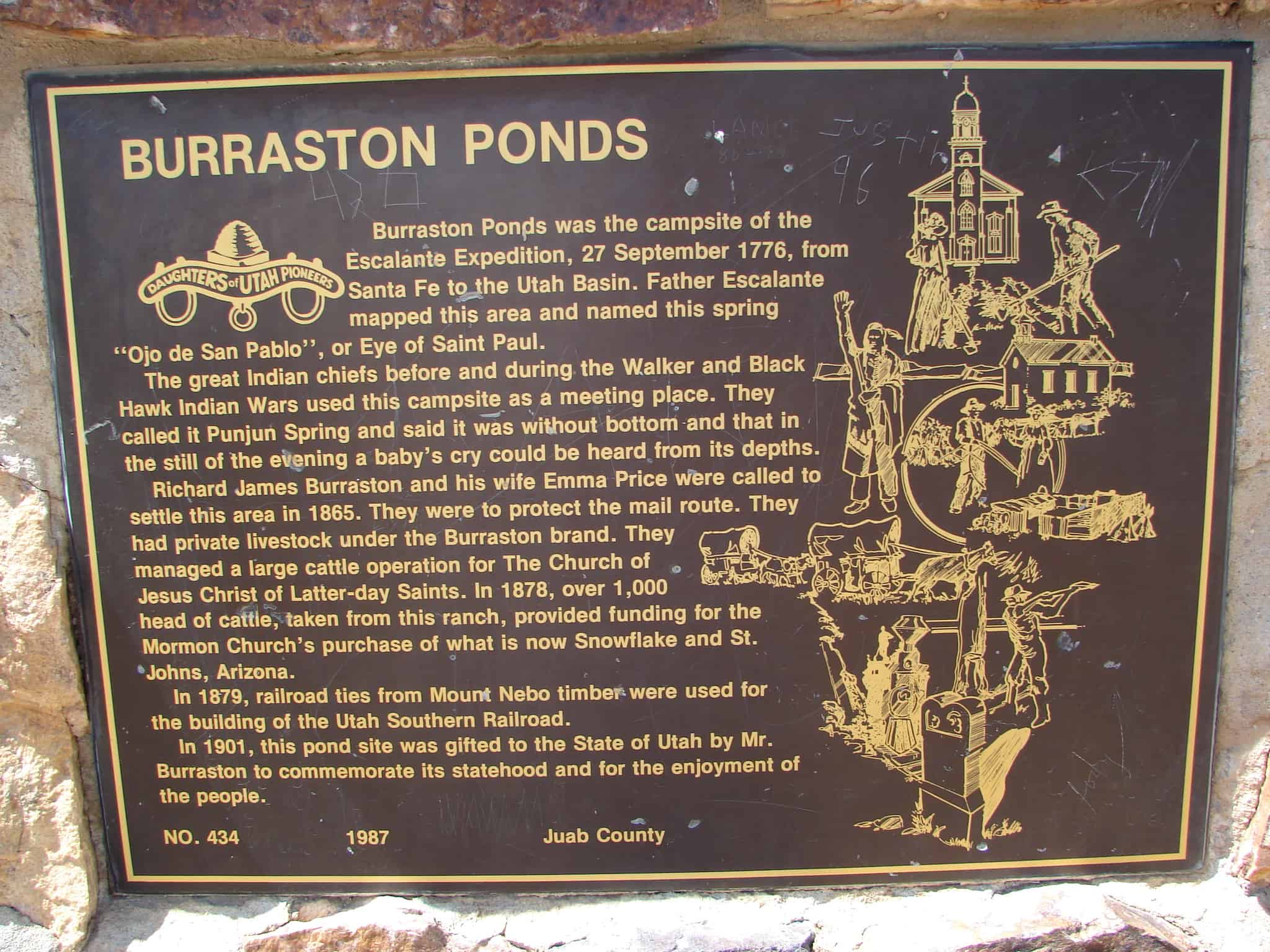
Spanish Fork was settled in 1857. The first flour mill was built by Archibald Gardner in 1858-59. The water for the mill came from the Spanish Fork River. The stream was enlarged to give sufficient power to run the mill. This mill was constructed of rough lumber.

The grinding was accomplished by large round granite stone burrs about four feet in diameter and two feet thick. These stones had grooves running across them; the lower stones remained stationary while the upper one rotated. The wheat came to the center of the burrs through a wooden chute. The husks of the kernels of wheat, when separated, were called bran; the next finer are the shorts; and the finest made of flour. The burrs frequently had to be dressed to keep them in good operating condition. Gardner sold the mill to the Spanish Fork Co-op in 1874. Shortly after it was torn down, it was replaced by a larger, two-story building with more advanced equipment.

This mill was built of shiplap lumber with gables facing north and south. The flumes carried water to the mill wheel, with a fall of twenty feet. Flour was made in the mill for fourteen years until April 15, 1888, when it burned to the ground, probably from spontaneous combustion. Within a short time, a four-story brick building was started at a cost of $40,000. New machinery was installed, and large steel rollers replaced stone burrs. The new mill burned in December 1927. It was never rebuilt. Today nothing remains of the once busy whirring mill.

picture16aug07-157

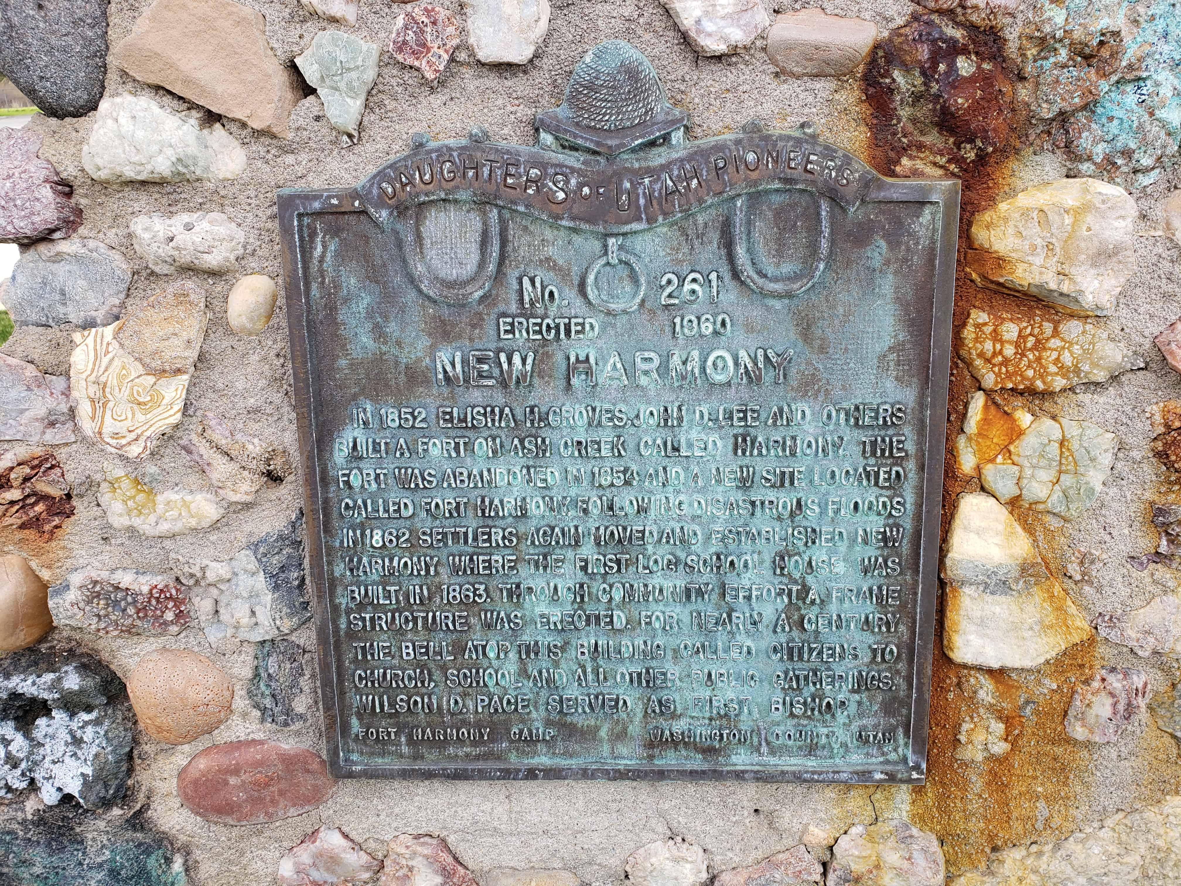
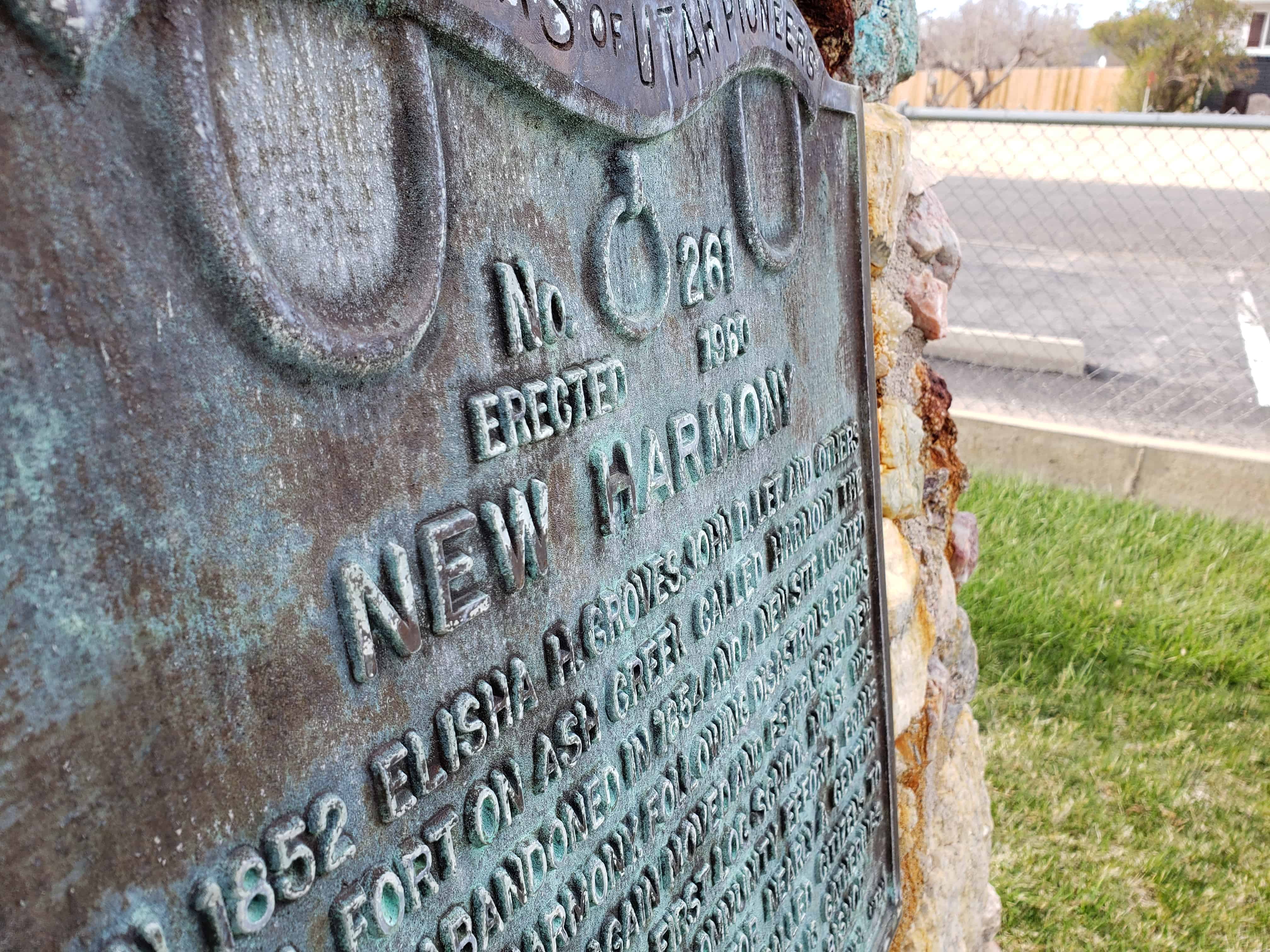
This is Daughters of Utah Pioneers historic marker #526, located at 200 East River Bottom Road in Spanish Fork, Utah.

Related:

  • D.U.P. Markers
Image

Old Spanish Fork Mills

Image

Old Spanish Fork Mills

More photos from 2013:
2013-11-02 14.04.25

2013-11-02 14.04.32
2013-11-02 14.04.34
2013-11-02 14.04.36

New Harmony, Utah

12 Tuesday Nov 2013

Posted by Jacob Barlow in Uncategorized

≈ 2 Comments

Tags

New Harmony, utah, Washington County

In 1852 Elisha H. Groves, John D. Lee and others built a fort on Ash Creek, called Harmony. The fort was abandoned in 1854 and a new site located called Fort Harmony. Following disastrous floods in 1862 settlers again moved and established New Harmony where the first log school house was built in 1863. Through community effort a frame structure was erected. For nearly a century the bell atop this building called citizens to church, school and all other public gatherings. Wilson D. Pace served as first Bishop.

Related Posts:

  • Fort Harmony
  • LDS Chapel
  • Military Training Campsite DUP Historic Marker
  • New Harmony DUP Historic Marker
  • New Harmony Grocery Store


Visit my list of places in Utah.


New Harmony

12 Tuesday Nov 2013

Posted by Jacob Barlow in Uncategorized

≈ 1 Comment

Tags

DUP, Forts, New Harmony, utah, Washington County

  • 2013-04-05-15-14-58

In 1852 Elisha H. Groves, John D. Lee and others built a fort on Ash Creek, called Harmony. The fort was abandoned in 1854 and a new site located called Fort Harmony. Following disastrous floods in 1862 settlers again moved and established New Harmony where the first log school house was built in 1863. Through community effort a frame structure was erected. For nearly a century the bell atop this building called citizens to church, school and all other public gatherings. Wilson D. Pace served as first Bishop.

This marker is located at The Church of Jesus Christ of Latter-day Saints in New Harmony, Utah.

  • Image
  • Image

Other DUP Markers are listed at JacobBarlow.com/dup

Mona, Utah

12 Tuesday Nov 2013

Posted by Jacob Barlow in Uncategorized

≈ 2 Comments

Tags

Burraston Ponds, Juab County, Mona, utah

Image

Originally named Clover Creek, then Willow Creek, then Starr and finally Mona – this small town is in Juab County between Santaquin and Nephi.

Mona is popular for the lavender farms, they bring many visitors in. They also are popular for Burraston Ponds, people come from hours away to swing on rope swings into the water or just fish.

Mona Posts:

  • Burraston Ponds
  • Kay’s Burnt Oak Ranch
  • Mona Bicentennial Memorial Park
  • Mt. Nebo Pioneer Park
  • Old Pioneer Cemetery
2017-07-02 19.05.23


Burraston Ponds

12 Tuesday Nov 2013

Posted by Jacob Barlow in Uncategorized

≈ 2 Comments

Tags

DUP, historic, Juab County, Mona, Nephi, utah

picture7sep07-053

Located near Mona, Utah in Juab County.

Burraston Ponds is popular for fishing and the rope swing, people come from all over to take part in both.

Burraston Ponds was the campsite of the Escalante Expedition, 27 September 1776, from Santa Fe to the Utah Basin. Father Escalante mapped this area and named this spring “Ojo de San Pablo” or Eye of Saint Paul. The great Indian chiefs before and during the Walker and Black Hawk Indian Wars used this campsite as a meeting place. They called it Punjun Spring and said it was without bottom and that in the still of the evening a baby’s cry could be heard from its depths. Richard James Burraston and his wife Emma Price were called to settle this area in 1865. They were to protect the mail route. They had private livestock under the Burraston brand. They managed a large cattle operation for the Church of Jesus Christ of Latter-day Saints. In 1878, over 1,000 head of cattle, taken from this ranch, provided funding for the Mormon Church’s purchase of what is now Snowflake and St. Johns, Arizona. In 1879, railroad ties from Mount Nebo timber were used for the building of the Utah Southern Railroad. In 1901, this pond site was gifted to the State of Utah by Mr. Burraston to commemorate its statehood and for the enjoyment of the people.

picture7sep07-052
Image

Visit my list of places in Utah or list of DUP markers.


Beaver Dam Wash and Welcome Creek area

12 Tuesday Nov 2013

Posted by Jacob Barlow in Uncategorized

≈ Leave a comment

Tags

Beaver Dam, Castle Cliff, utah, Washington County, Welcome Creek

20130302_110904


There isn’t much out in this area unless you’re a geocacher, and if you are there is a lot. There is a series of caches hidden in locations so that if viewed on a map they’ll look like a kokopelli blowing his flute. There’s another series in the shape of a star nearby as well.

Image

Kokopelli in the desert

I’ve personally hiked the star, and a small part of the kokopelli, I plan on going back to finish it.

Here’s a few hiking photos from out there.

ImageImageImageImage

Hiking the kokopelli with friends


Visit my list of places in Utah.


More photos from a trip on 05 March 2016:

2016-03-05 11.30.52
2016-03-05 11.47.19
2016-03-05 15.45.16
2016-03-05 15.55.21
2016-03-05 16.04.40
2016-03-05 16.05.12
2016-03-05 16.12.49
2016-03-05 16.12.53

Castle Cliff, Utah

12 Tuesday Nov 2013

Posted by Jacob Barlow in Uncategorized

≈ Leave a comment

Tags

Castle Cliff, historic, utah, Washington County

I just love places like Castle Cliff, places where there used to be something, there isn’t anymore and I can find old documents, even photos to prove it. It’s a cool feeling to be somewhere and know that it really used to be something. All my life I’ve called them “used-to-be-towns” and this is a good one.

My friend Steve said this:
I remember this spot well. 50 years ago or so (I’m dating myself), it was a rest stop on the old highway called Castle Cliffs. Their main commodoty was water. After going up “Utah Hill”, many cars overheated, as well as their occupants. They had those old canvas water bags that you put on your bumper and the water stayed cold by evaporation. However, it wasn’t cheap. I think they also had a gift shop, curios, rocks, and anything else tourists would buy. The building across the road was the gas station and take-you-for-all-you-had garage. I don’t remember buying gas here, but I remember Castle Cliffs

Before I-15 was open through the gorge; Old 91 was busy with lots of trucks on this slow winding two-lane road from Nevada to Utah. There was a rest stop on the old highway called Castle Cliffs. Its main commodity was water. After going up “Utah Hill”, many cars, as well as their occupants, overheated. They had those old canvas water bags that you put on your bumper and the water stayed cold by evaporation. However, it wasn’t cheap. Overheated cars could get water at $1.00 a gallon, which would roughly be $20.00 a gallon in today’s money! Gas was 12 cents a gallon. The gas station had a “take you for all you had” garage. They also had a gift shop, curios, rocks, and anything else tourists would buy. This was a perfect place for a rest stop because of the spring above the cliffs that supplied the water. On the same side of the road is a natural cave. Across the road were 3 motel-like cabins.(*)

  • Image

The location of the old Castle Cliff Store.

  • Image

  • Image

Castle Cliff from across the road

  • Image
  • Image
  • Image
  • Image
  • Image
  • Image
  • Image
  • Image
  • Image
  • Image

The water tank that was filled with the spring

  • Image

Here are some old photos, an old painting and a poem of and about Castle Cliff.

  • Image
  • Image
  • Image
  • Image

Little Rock Canyon

12 Tuesday Nov 2013

Posted by Jacob Barlow in Uncategorized

≈ 1 Comment

Tags

Caves, Mines, Springville, utah, utah county

I love Little Rock Canyon, it is located at the north end of Springville, Utah. The canyon is covered with slick rockslides and gorgeous cliffs, there are a few caves and mines as well.

One cave, far up on the North side has many names, Springville Cave, Another Springville Cave Link, C Cave, Rock Cave, Gold Bar Cave, and is the place where in the 1980′s two boys found a gold bar.

If you want to hike up the canyon there is a trail that goes up the South side, if you’re looking for the caves/mines go up the bottom of the canyon and towards the North side.

Image
Image
Image

On May 5th, 2013 we hiked up to “Rabbit Ears” to celebrate my birthday, I hadn’t been there in a long time.
Here’s a picture of Brady entering, and another of the “ears.”

Image
Image

Visit my list of places in Utah.


EDIT:
Here are pictures I took in 2007 I just dug up, the canyon, the cache I hid there and the “rabbit ears.”

1e30dfeb-00bd-4782-b1ae-da744bf8bd2c
777f35f7-2d02-4b8f-a04a-a7709ea48234
d2974458-f567-4f82-b809-699ea14d8d84

Here’s a few other pictures I took farther up the canyon, a large rockslide I climbed up and explored.
8b511434-6e4d-4011-936b-58492dc0467e

b06df564-7c8d-46b3-ba77-6880503fa99e
f468503b-488a-4191-a0ae-1581534050e4

Cedar Hills, Utah

12 Tuesday Nov 2013

Posted by Jacob Barlow in Uncategorized

≈ Leave a comment

Tags

Alpine, American Fork, Cedar Hills, Highland, Lehi, utah, utah county

2017-06-11 19.33.03

Located between Alpine and Highland on the slopes of Mount Timpanogos, Cedar Hills is small but one of the faster growing towns in Utah.

Image

Cedar Hills

(taken from the city’s website)Cedar Hills is built upon an alluvial fan, or bench, created thousands of years ago when it was a shoreline of Lake Bonneville. Early settlers referred to the area as “the Bench.” Because of the growth of cedar trees (later becoming Manila’s source of Christmas trees), the area was later referred to as Cedar Hills. The bench provides a beautiful view of the surrounding mountains, Utah Lake, and Utah Valley. Cedar Hills was established as a community in 1977. The surrounding cities such as Pleasant Grove and Alpine were settled in 1849 and 1850.

Various forms of wildlife flourished in the area. Coyotes prowled along the bench. Wild cats, red foxes, bears, deer, skunks, and rabbits also lived in the area. Some deer, skunks, and rabbits can still be seen around Cedar Hills.

The dry bench upon which Cedar Hills is located provided little attraction to Native Americans. They preferred camping near streams, such as in American Fork Canyon. Several Native American artifacts were found upon the bench, however, including an Indian bowl (found by Paul Adams and currently on display at a Brigham Young University museum) and numerous arrowheads. The arrowheads were probably dropped during skirmishes between the Utah Valley Indians and the Shoshones.

Between 1849 and 1850, early settlers began to make their homes in settlements around Cedar Hills. A large portion of Cedar Hills was used for dry farming, which proved to be unsuccessful. A few planted plots existed among the sage brush. Much of the area was used to pasture livestock. Other forms of livelihood among early settlers of Cedar Hills included trapping and turkey farming.

The bench became a turkey ranch. The David Evans Company Advertising Agency, advertiser for the National Turkey Federation, would take pictures of the Adams turkey ranch because of its impressive background. In 1939, the National Poultry Congress in Cleveland, Ohio, displayed photographs of turkeys raised on the beautiful bench upon which Cedar Hills is now located. And, as NBC ran a news story about turkey farming on the bench, the photographer was taken back by the beauty of the bench and continued to say, “beautiful, beautiful.” In 1962, the Saturday Evening Post also ran stories about turkeys living upon the bench.


Visit my list of places in Utah.


St. George Dinosaur Discovery at Johnson Farm

12 Tuesday Nov 2013

Posted by Jacob Barlow in Uncategorized

≈ 2 Comments

Tags

museums, Prehistoric, St. George, Washington, Washington County

picture01march08-006

St. George Dinosaur Discovery Site at Johnson Farm

Located at 2180 E Riverside Drive in Saint George, Utah(435) 574-3466
http://www.dinosite.org/

Hours:

Mon-Sat 10 am – 6 pm

Sun 11 am – 5 pm

We stopped by the dinosaur site a couple weeks ago, it was interesting and fun for the kids. I think it was $27 for our family of two adults and four kids.
The kids enjoyed it, there wasn’t a lot to see but it was cool to see what kind of tracks and such were found there in our very own St. George. They had a video, some models, many, many tracks and a place for kids to make origami.
It was worth it to see once, probably not twice.

ImageImageImageImageImageImageImageImageImageImageImage


Visit my list of places in Utah.


← Older posts
Newer posts →

Follow Jacob

Follow Jacob

Come wander with me on Youtube.

Blog Stats

  • 2,100,700 hits

Social and Other Links

BarlowLinks.com

Recent Posts

  • Scout Monument
  • Provo High School Seminary Building
  • 821 E 100 S
  • 820 E 100 S
  • 817-819 E 100 S

Archives

Loading Comments...