• About JacobBarlow.com
  • Cemeteries in Utah
  • D.U.P. Markers
  • Doors
  • Exploring Utah Email List
  • Geocaching
  • Historic Marker Map
  • Links
  • Movie/TV Show Filming Locations
  • Oldest in Utah
  • Other Travels
  • Photos Then and Now
  • S.U.P. Markers
  • U.P.T.L.A. Markers
  • Utah Cities and Places.
  • Utah Homes for Sale
  • Utah Treasure Hunt

JacobBarlow.com

~ Exploring with Jacob Barlow

JacobBarlow.com

Monthly Archives: December 2013

Bingham’s Fort

11 Wednesday Dec 2013

Posted by Jacob Barlow in Uncategorized

≈ 4 Comments

Tags

DUP, Forts, historic, Ogden, utah, Weber County

picture19oct08-021

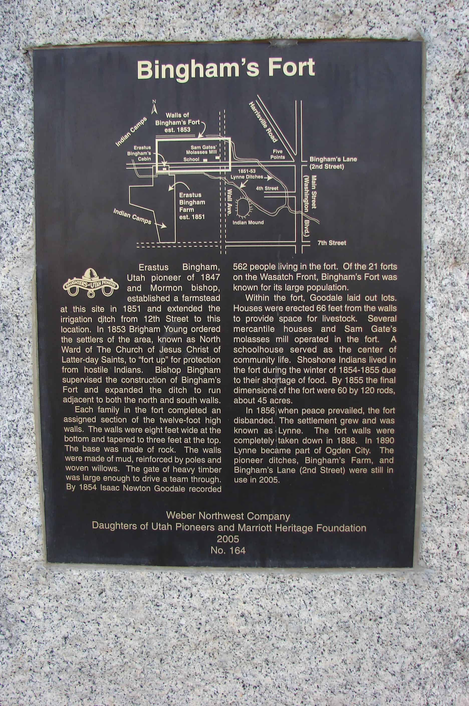
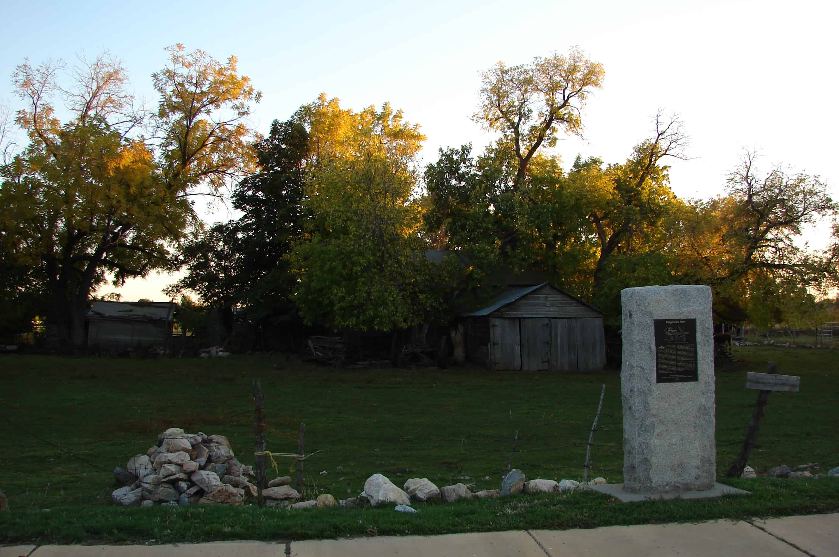
Erastus Bingham, Utah pioneer of 1847 and Mormon bishop, established a farmstead at this site in 1851 and extended the irrigation ditch from 12th Street to this location. In 1853 Brigham Young ordered the settlers of the area, known as North Ward of The Church of Jesus Christ of Latter-day Saints, to “fort up” for protection from hostile Indians. Bishop Bingham supervised the construction of Bingham’s Fort and expanded the ditch to run adjacent to both the north and south walls.

Each family in the fort completed an assigned section of the twelve-foot high walls. The walls were eight feet wide at the top. The base was made of rock. The walls were made of mud, reinforced by poles and woven willows. The gate of heavy timber was large enough to drive a team through. By 1854 Isaac Newton Goodale recorded 562 people living in the fort. Of the 21 forts on the Wasatch Front, Bingham’s Fort was known for its large population.

Within the fort, Goodale laid out lots. Houses were erected 66 feet from the walls to provide space for livestock. Several mercantile houses and Sam Gate’s molasses mill operated in the fort. A schoolhouse served as the center of community life. Shoshone Indians lived in the fort during the winter of 1854-1855 due to their shortage of food. By 1855 the final dimensions of the fort were 60 by 120 rods, about 45 acres.

In 1856 when peace prevailed, the fort disbanded. The settlement grew and was known as Lynne. The fort walls were completely taken down in 1888. In 1890 Lynne became part of Ogden City. The pioneer ditches, Bingham’s Farm, and Bingham’s Lane (2nd Street) were still in use in 2005.

picture19oct08-020
Map by Bill Cobabe

First Grist Mill in Weber County

10 Tuesday Dec 2013

Posted by Jacob Barlow in Uncategorized

≈ 1 Comment

Tags

DUP, First, Grist Mills, historic, Ogden, utah, Weber County

First Grist Mill in Weber County

This flour mill was built in the fall of 1850 by Lorin Farr, first mayor of Ogden, and continued to operate until 1862. It was a 30 x 40 foot two story building of lumber and rock. The grain was ground by the use of burrs several of which were set up.

This other plaque is also located there:

  • Image

This flour mill was built in the fall of 1850 by Lorin Farr, first mayor of Ogden, and continued to operate till 1862. There was a 30×40 foot two story building of lumber and rock. The grain was ground by the use of burrs several of which were set up.

  • Image

Stage Coach Station

09 Monday Dec 2013

Posted by Jacob Barlow in Uncategorized

≈ Leave a comment

Tags

DUP, historic, Ogden, Pleasant View, Stage Coach, utah, Weber County

picture19oct08-024

Approximately one and a quarter mile west from this site John and Sarah Ann Mower operated a stage coach station. During 1860-1880 it served the Holladay Overland Lines which were under the management of Wells Fargo Company. The line ran 950 miles to The Dalles, Oregon, and branched off 400 miles farther to Virginia City, Montana. Coaches traveled the line three times each week. Mower changed the horses and made repairs to harness and coach. Mrs. Mower served meals to the passengers.

picture19oct08-022

Other DUP Markers are listed at JacobBarlow.com/dup

Salt Creek Fort

04 Wednesday Dec 2013

Posted by Jacob Barlow in Uncategorized

≈ 5 Comments

Tags

DUP, Forts, Juab County, Nephi, Salt Creek, utah

picture7sep07-049

Daughters of Utah Pioneers
No. 2
Erected November 1934
Salt Creek Fort
Completed in November 1854, by the Pioneers of Salt Creek (Nephi) for protection against Indians. The inclosure (sic) was 3 blocks square, from 1st West to 2nd East, and from 1st North to 2nd South Streets. Markers have been placed at the corners. The original wall, composed of gravel, mud and straw, was 12 feet high, 6 feet wide at bottom and 2 1/2 feet wide at top, 420 rods in length. Gates were provided in the north and the south walls. This section of the original wall was removed to this site for preservation, November 7, 1933. Fort Wall Camp, Daughters of Utah Pioneers, Juab County, Utah.

picture16dec07-026

picture7sep07-049
picture7sep07-048

See the markers at the locations of the corners of the old fort here: http://jacobbarlow.com/2014/05/21/nephi-fort/

Check out all of the historic markers placed by the Daughters of Utah Pioneers at JacobBarlow.com/dup

Lynndyl, Utah

03 Tuesday Dec 2013

Posted by Jacob Barlow in Uncategorized

≈ 1 Comment

Tags

Lynndyl, Millard County, utah

Lynndyl City is a small isolated community located in Millard County and is home to 106 residents, according to the 2010 US Census. Lynndyl was first established as an unnamed junction for the Los Angeles and Salt Lake Railroad around 1904. With a depot being constructed and a telegraph line being completed also in 1904, railroad employees began moving into the area around 1907. The name Lynndyl was created in 1904 when the first telegraph operator tried out her new system by sending a message to the next telegraph station. The operator at the other end asked the telegraph woman for her location, she quickly looked at her shoe, which was made in Lynn, Massachusetts, and responded, “This is Lynn.” Lynn Junction was then established and later it was changed to Lynndyl, to distinguish the community from another town in Utah named Lynn (Ekins 551).

According to a May 27, 1993, article in the Millard County Chronicle, the history of Lynndyl’s existence is tied directly to the railroad. The first train tracks within the city were laid in 1879 for the purpose of sending trains to the silver mining town of Frisco, to the south. In 1906 the first section house and round house with 18 stalls was constructed, and each were filled with workman repairing and maintaining locomotives. With the rail industry growing, Lynndyl was one of the largest railroad terminals between Omaha, Nebraska, and Los Angeles, California.

Lynndyl was a rough town full of working men, gambling and bootlegging. Yet, the railroad also kept the town alive and brought work to many of its residents (Hellenbrand). With the coming of water in 1912, farmers began settling the area in 1913. Yet, many became discouraged with turning the barren land into fertile fields and left Lynndyl after a short time. During the years of the Great Depression, the town saw decline, yet still had numerous buildings dedicated to the rail industry and still had hundreds of employees. During World War II, the rail yards saw a boost of activity with soldiers and military equipment coming through the community for supplies. However, this soon changed when the technology of the locomotive was altered. New diesel locomotives were able to run faster and longer without being required to have numerous stops. The need to resupply in Lynndyl was no longer required and the back shops were moved to Provo. By 1950, only 8 passenger trains and 6 freight trains rode through the town on a daily basses. With the loss of jobs, many people moved out of the community to find work elsewhere. As time progressed many structures were abandoned and eventually demolished. In the late 1970s and early 1980s new hope was brought to the small town, when the coal-fired Intermountain Power Project plant was constructed nearby. Other than farming, this is the only industry, and population has not increased.

Related:

  • Cemetery
  • Princess Recreation Hall / Lynndyl LDS Meetinghouse

  • Image

Spanish Fork, Utah

03 Tuesday Dec 2013

Posted by Jacob Barlow in Uncategorized

≈ 70 Comments

Tags

Mapleton, Palmyra, Salem, spanish fork, Springville, utah, utah county

2016-10-03-17-44-38
ingress_20131203_222319_12

Spanish Fork is eight miles south of Provo on I-15 and the Spanish Fork River. Spanish Fork was an out-growth of Palmyra, Located to the northwest. As the community developed, Palmyra diminished and eventually became a suburb of Spanish Fork. In the early days, both settlements existed with one fort, Fort St. Luke. Spanish Fork received its name from the adjacent river, which was named by the 1776 Dominguez-Escalante expeditions.

Spanish Fork Posts:

  • Beet Factory
  • Cemetery
  • Christmas Box Angel
  • David H. Jones House
  • Del Monte Cannery
  • Dominguez y Escalante Expedition
  • D.U.P. Museum
  • Escalante Cross
  • Festival of Lights
  • First Icelandic Settlement in USA
  • Glade’s Drive Inn
  • Grist Mills
  • Hide-Tallow Service Station
  • Holi Festival of Colors (2018)
  • Icelandic Memorial
  • Indian Farm
  • Leland
  • Library
  • Made Men Filming Site
  • Main Street Chapel
  • Old Fort
  • Parks in Spanish Fork
  • Pioneer Heritage Cemetery 
    • Heritage Cemetery DUP Marker
    • Pioneer Cemetery DUP Marker
  • Railroad Depot
  • Spanish Fork Grist Mills
  • Spanish Fork High School Gymnasium
  • Spanish Oaks Reservoir
  • Spring Plowing
  • Thurber School / City Office Building
  • Water Park
  • Wind Park
  • Spanish Fork sorted by Address
ingress_20140310_154112_0
Image

Cache Junction, Utah

01 Sunday Dec 2013

Posted by Jacob Barlow in Uncategorized

≈ Leave a comment

Tags

Benson, Cache County, Cache Junction, Logan, Mendon, Nibley, utah

Image

Cache Junction is ten miles northwest of Mendon, near a spring. The site was initially settled by Sylcanus Collett in 1867. The town was established in 1890 as an outgrowth of Benson and it became an important railroad junction on the union Pacific Railroad. Originally this area was divided into Petersboro No. 1 and No. 2 became Cache Junction. The railroad no longer uses the stop but a cafe and a few local residents still remain.

Ricks Spring

01 Sunday Dec 2013

Posted by Jacob Barlow in Uncategorized

≈ Leave a comment

Tags

Cache County, Logan, Logan Canyon, Springs, utah

Thomas E. Ricks arrived in Cache Valley with his family In 1859. Between chores such as building a school and a cabin for his family, he explored Logan Canyon In search of timber. During one trek he discovered this spring which was later named for him.

Frontier communities required large quantities of lumber to build churches, businesses, homes, and fences. In 186. Thomas Ricks and other town leaders proposed building a road in Logan Canyon to that timber could be hauled to the valley. As timber supplies close to Login were exhausted, the road was pushed further up the canyon. Brigham Young, President of the Church of Jesus Christ of Latter Day Saints (Mormons), recommended in 1889 that the road be completed to Bear Lake Valley Thomas Ricks and other volunteers accepted the challenge and completed the first twenty-five miles to what is now known as Ricks Spring before winter.

For many years. Ricks Spring was believed to be pure mountain spring water. Visitors drank from the spring and filled jugs with water to take home that is until they became sick. In 1972, an ice jam on Logan River provided the answer to the origins of Ricks Spring.

Ricks Spring usually slows to a trickle in November, and begins to flow again in April as the snow melts. In 1972, however, a severe blizzard caused an ice flow to dam Logan River. Suddenly, Ricks Spring began to flow in January. When the ice jam cleared, the flow slowed. Later, bitter cold weather caused another ice jam on Logan River and the flow of Ricks Spring increased once again. Scientists placed green dye in Logan River and the dye appeared in Ricks Spring indicating that they are directly connected by an underground fracture in the rock.

This spring has always been a “childhood memory” of mine, my dad stopped here once and told us about how he came here when he was younger.

Newer posts →

Follow Jacob

Follow Jacob

Come wander with me on Youtube.

Blog Stats

  • 2,104,008 hits

Social and Other Links

BarlowLinks.com

Recent Posts

  • Scout Monument
  • Provo High School Seminary Building
  • 821 E 100 S
  • 820 E 100 S
  • 817-819 E 100 S

Archives

Loading Comments...