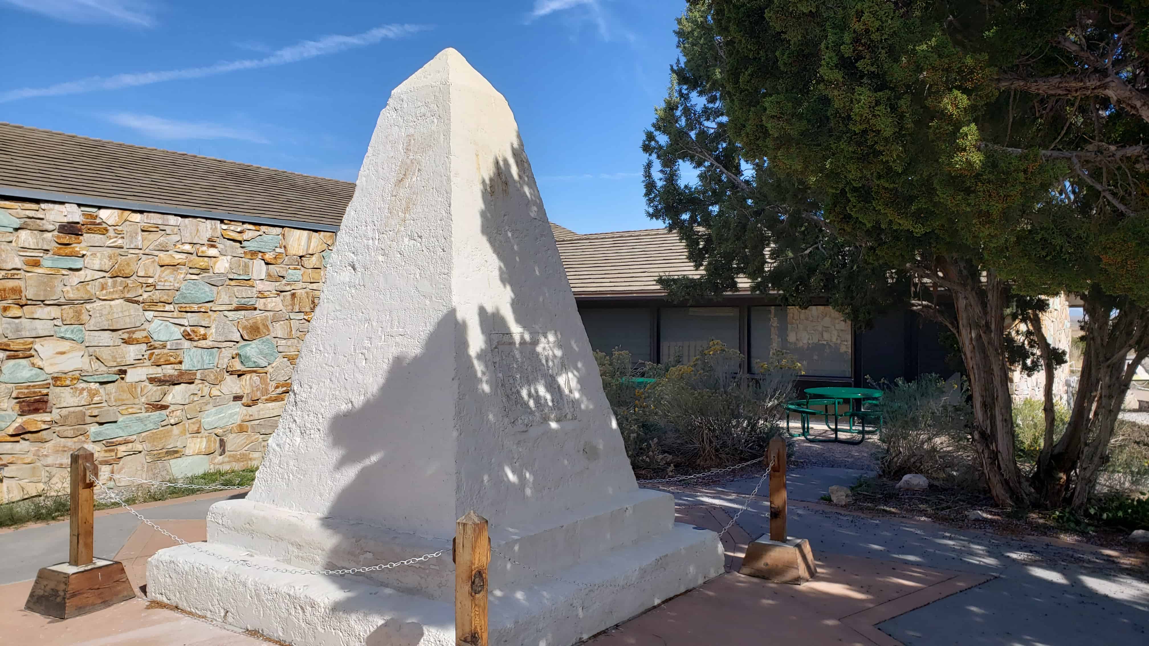
Out benchmark hunting, Benchmark: LO0794 ” 5 12 A ” was a fun one. It’s cool to see these last over 100 years, even if this one wasn’t in great shape. This was placed June 4th, 1912.
01/01/1948 by USGS (GOOD)
DESCRIBED BY US GEOLOGICAL SURVEY 1948 LOCATED ON LOW GREASEWOOD-COVERED RIDGE. TO REACH FROM ELBERTA, DRIVE N. ON RD. FOR ABOUT 9.0 MI. TO RD. FORKS, TURN RIGHT E. AND DRIVE TO ABANDONED HOUSE AND CORRAL TURN N. AND FOLLOW 1.0 MI. TO GATE IN FENCE CORNER, CONTINUE ABOUT 0.4 MI. TO DIM RD. BEARING NE. FOLLOW ABOUT 1000 FT. STATION IS ABOUT 600 FT. S. ON SAGE BRUSH RAISED GROUND. STATION MARK – USBR TRIANGULATION CONCRETE POST INSCRIBED —USRS NO JUNE 4 1912— REFERENCE MARKS – NONE.
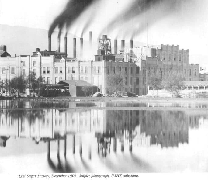
The Lehi Factory of the Utah Sugar Company, of the Church of Jesus Christ of Latter-day Saints, occupies a pre-eminent place among early sugar mills in America. As historian Leonard Arrington has written: “It was the first sugar-beet factory in the Mountain West, the first to utilize beets grown by irrigation, the first to use American made machinery, the first to use the ‘osmoses process’ of reprocessing molasses, the first to built auxiliary cutting stations and the first to have been established as part of a great social and religious movement.”
The factory was built in 1891 and the first sugar strike was completed on October 15 of that year. During that first growing season 565 farmers planted 1500 acres of sugar beets which processed into 12,500 100-pound bags of sugar. The success of the factory had a dramatic effect on Lehi‘s financial well-being.
Between 1890 and 1896 nearly thirty new businesses came into existence. Many local men, with valuable experience gained at this factory, were relocated to other areas and helped establish many additional factories in Utah and Idaho. The Utah Sugar Company eventually became the Utah and Idaho Sugar Company and then the U and I Sugar Company.
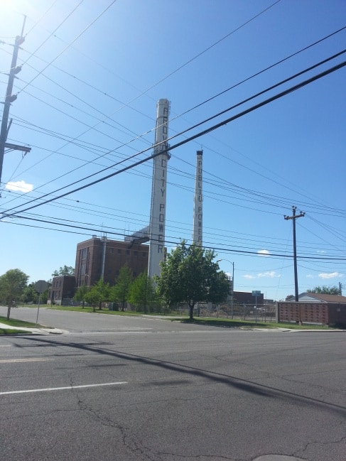
During 1899 and 1900 the factory doubled in size. To accommodate the growing demands for sugar during World War I, a huge fourteen-million-pound capacity warehouse was completed along with the 184-foot high smokestack, both of which are still standing in 2008 (and 2014).
The demise of the Lehi Sugar Factory was ultimately caused by two beet maladies: nematodes (round worms) and “curly top” from white fly infection. Farmers did not plan sufficient acreage in this area to sustain the factory and it closed after the 1924 campaign although beets continued to be grown locally and processed at other factories until the 1960s. The machinery was shipped to new factories in other locations and in 1939 the main buildings of this factory were demolished. Many of the bricks were used to construct the Joseph Smith Memorial Building on the BYU Campus and the Lehi First Ward Chapel.
The large sugar warehouse continually stored sugar from 1914 until the late 1960s. The Utah and Idaho Sugar Company sold the property in 1979 to the Thomas Peck and Sons trucking Company. In 1996 the smokestack was remodeled into a cell phone antenna tower. Until Micron established its Lehi Division during the late 1990s, no single business provided greater financial benefits to the local economy than the Sugar Factory.
After the initial success of the Lehi factory, many other factories were built around the state. Spanish Fork in particular became the bloodline for the Lehi factory, as the world’s largest and longest pipeline used to transport beets ran between the two. Built sometime in the early 1900s, the factories were owned by the Utah-Idaho sugar company (originally a commercial venture of the LDS / Mormon Church). The current Spanish Fork factory that you can see today was was built in 1916. Much of the plant equipment was transferred from Nampa Idaho to the Spanish Fork area.
See other historic markers in the series on this page for SUP Markers.
The stack is also an NGS Benchmark. “LO0797” LEHI U I SUGAR CO STACK
“The last rail is laid. The spike is driven. The Pacific Railroad is completed.” Here at Promontory, Utah at 12:47 p.m. on May 10, 1869 the driving of a golden spike completed the first transcontinental railroad climax of a dramatic railroad-building race between the Union Pacific building from the east and the Central Pacific building from the west. This event symbolized attainment of a long sought goal – a direct transportation route to the Pacific Ocean and the China trade and it achieved the great political objective of binding together by iron bonds the extremities of continental United States. A rail link from ocean to ocean.”
In 1954, the National Park Service assumed ownership of the aging monument, which had been damaged by years of weathering and vandalism. The interior had also been severely damaged by ground water that had wicked up into the monument through its buried base. Early restoration attempts unintentionally contributed to the damage by using materials that did now allow for evaporation of water trapped inside the monument. Based on state of the art technology, the National Park Service began a new repair process in 2001.
Removing the concrete monument from the ground to prevent further moisture absorption and allowing it to dry.
Transferring the monument to its present location.
Replacing old stucco, paint, and patches with a new breathable masonry coating.
Protecting the monument through regularly scheduled maintenance.
Significance of the Monument
In 1916, the Southern Pacific Railroad (formerly the Central Pacific Railroad) placed the monument near the site where the nation’s first transcontinental railroad was completed. For decades, it stood there, a lonely reminder of the driving of the last spike on May 10, 1869 at Promontory Summit, Utah Territory. Today, the handsomely restored monument remains an icon of westward expansion, the settlement of northern Utah and commemorates an historic event that transformed America.
As western settlement increased, the need for an overland railroad was voiced by various groups, including Utah pioneers who petitioned Congress, Mar. 1852. The Enabling Act of 1862 authorized construction. First rails laid by Central Pacific in Sacramento, Cal. Oct. 26, 1863; by Union Pacific near Omaha, Neb. July 10, 1865. Strong and determined men hewed the iron road to complete a gigantic task that ended with driving of the Golden Spike at Promontory, Utah May 10, 1869. In lieu of cash settlement on his contract, Brigham Young accepted as partial payment from Union Pacific $600,000 in iron and rolling stock, with which Utah Central Railroad was built, Ogden to Salt Lake City, and dedicated Jan. 10, 1870.
Check out all of the historic markers placed by the Daughters of Utah Pioneers at JacobBarlow. com/dup
Documented History (by the NGS) Unknown by USGS (MONUMENTED) 01/01/1934 by NGS (GOOD) DESCRIBED BY NATIONAL GEODETIC SURVEY 1934 IN HEBER. AT HEBER, WASATCH COUNTY, AT THE COURTHOUSE, AND IN LINE WITH THE SOUTH FENCE. A UNITED STATES GEOLOGICAL SURVEY STANDARD DISK, STAMPED 5593 AND SET IN THE TOP OF A GRANITE POST PROJECTING 2 FEET ABOVE GROUND.
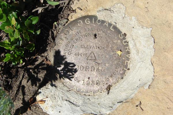
Documented History (by the NGS) 01/01/1938 by USGS (MONUMENTED) DESCRIBED BY US GEOLOGICAL SURVEY 1938 LOCATED 8.5 MI. E. THEN 1 MI. S. OF TOWN OF MT. PLEASANT, 4.5 MI. S. OF JUNCTION OF MT. PLEASANT RD. WITH SKYLINE DRIVE, ON N. END OF ROCK KNOLL WHICH BREAKS ABRUPTLY TO E. AND IS COVERED WITH TIMBER ON W. SLOPE. (THIS KNOLL IS NOT THE HIGHEST POINT IN VICINITY BUT WAS USED TO MAKE —HILL TOP— TRIANGULATION STATION VISIBLE THROUGH HILL TOP PASS. NEAR NW. CORNER OF QUADRANGLE.) THIS KNOLL IS 1 MI. S. OF A WIDE, SHALLOW SADDLE IN RIDGE ALONG SKYLINE DRIVE. STATION IS ABOUT 150 FT. E. OF AND ABOUT 100 FT. ABOVE SKYLINE DR. TO REACH FROM FAIRVIEW, GO N. ON U.S. HIGHWAY 89 FOR 0.4 MI. TO STATE 31, THEN E. ON STATE HIGHWAY 31 FOR 11.5 MI. TO JUNCTION OF STATE HIGHWAY 31 AND SKYLINE DRIVE, THEN RIGHT S. ON SKYLINE DRIVE FOR 11.5 MI. TO POINT ON SKYLINE DRIVE OPPOSITE STATION. STATION MARK – STANDARD TABLET STAMPED —JORDAN 1938— CEMENTED IN SANDSTONE BOULDER. REFERENCE MARK NO.1 – STANDARD REFERENCE MARK TABLET STAMPED —NO.1— CEMENTED IN BOULDER, 27.38 FT. DISTANT FROM STATION MARK, S 19 DEG 02 MIN W. REFERENCE MARK NO.2 – STANDARD REFERENCE MARK TABLET STAMPED —NO.2— CEMENTED IN BOULDER, 14.5 FT. DISTANT FROM STATION MARK, N 63 DEG 31 MIN W.
(the above text is from the description on the benchmark recovery sheet when it was checked on)