• About JacobBarlow.com
  • Cemeteries in Utah
  • D.U.P. Markers
  • Doors
  • Exploring Utah Email List
  • Geocaching
  • Historic Marker Map
  • Links
  • Movie/TV Show Filming Locations
  • Oldest in Utah
  • Other Travels
  • Photos Then and Now
  • S.U.P. Markers
  • U.P.T.L.A. Markers
  • Utah Cities and Places.
  • Utah Homes for Sale
  • Utah Treasure Hunt

JacobBarlow.com

~ Exploring with Jacob Barlow

JacobBarlow.com

Tag Archives: Benchmarks

United States Meridian Base 1869

19 Monday Sep 2016

Posted by Jacob Barlow in Uncategorized

≈ 2 Comments

Tags

Benchmarks, historic, Salt Lake, Salt Lake City, Salt Lake County, Temple Square, utah

2016-07-02-14-40-54

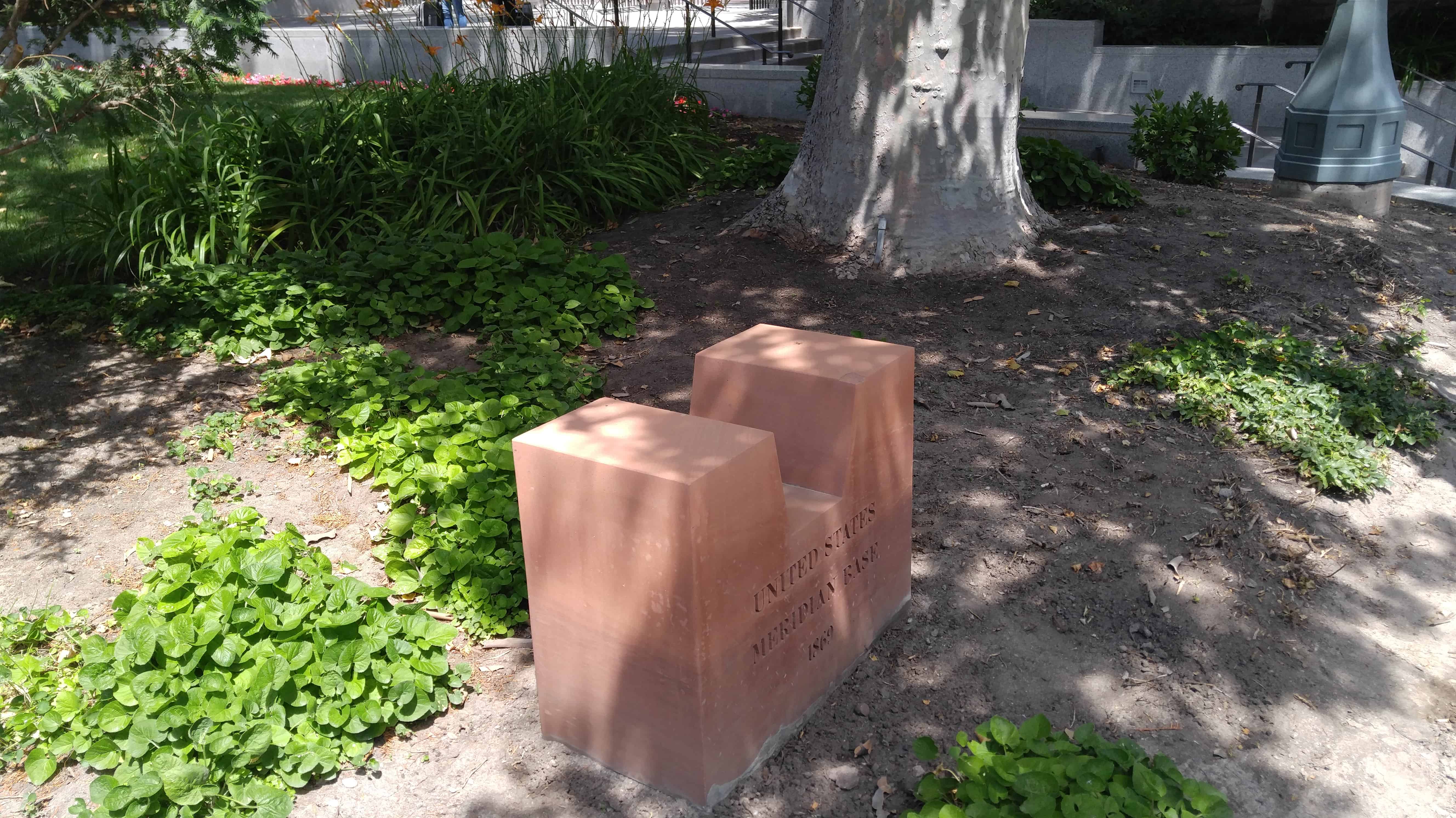
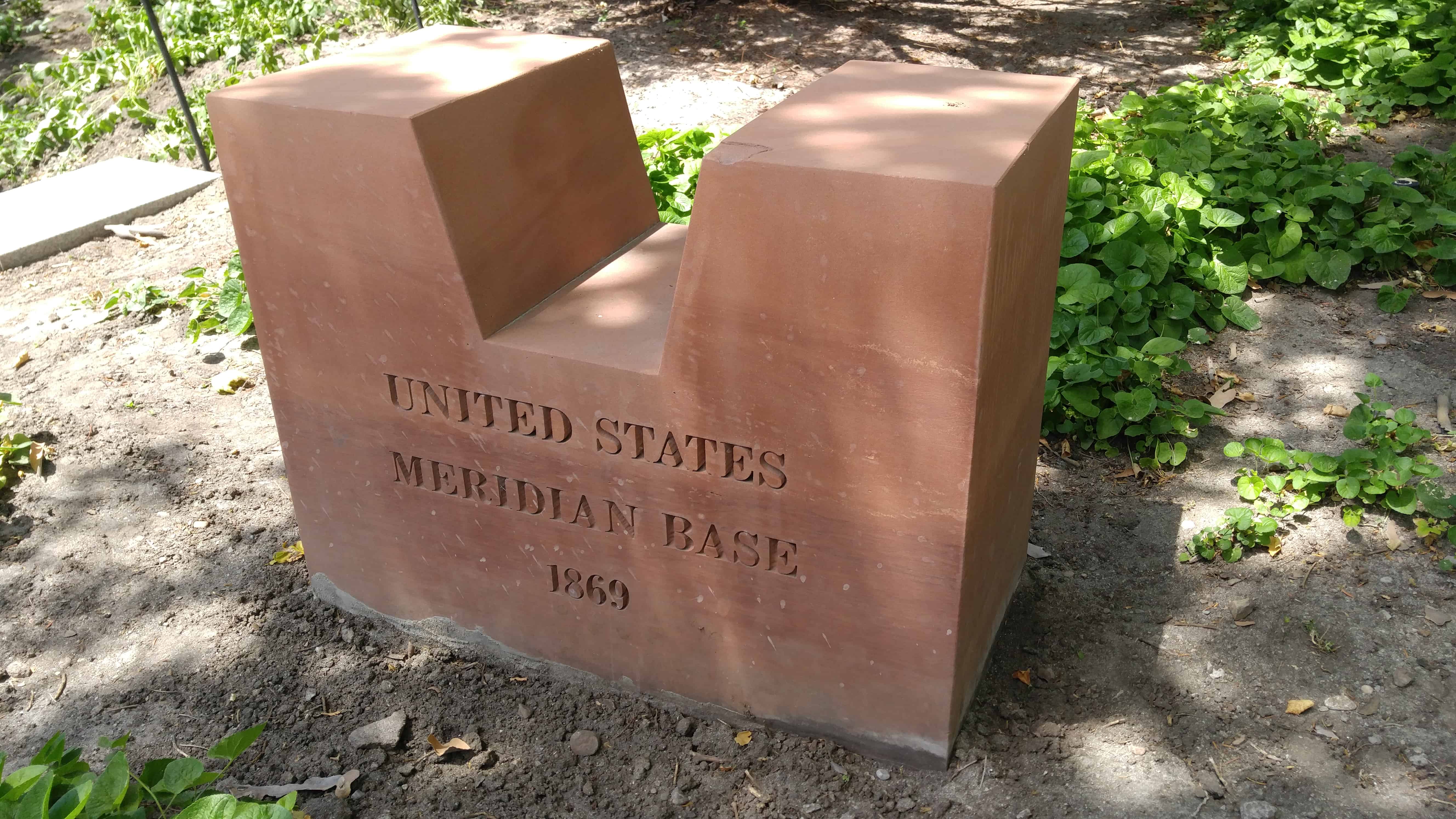
On Temple Square, just north of the east end of the south visitor center.

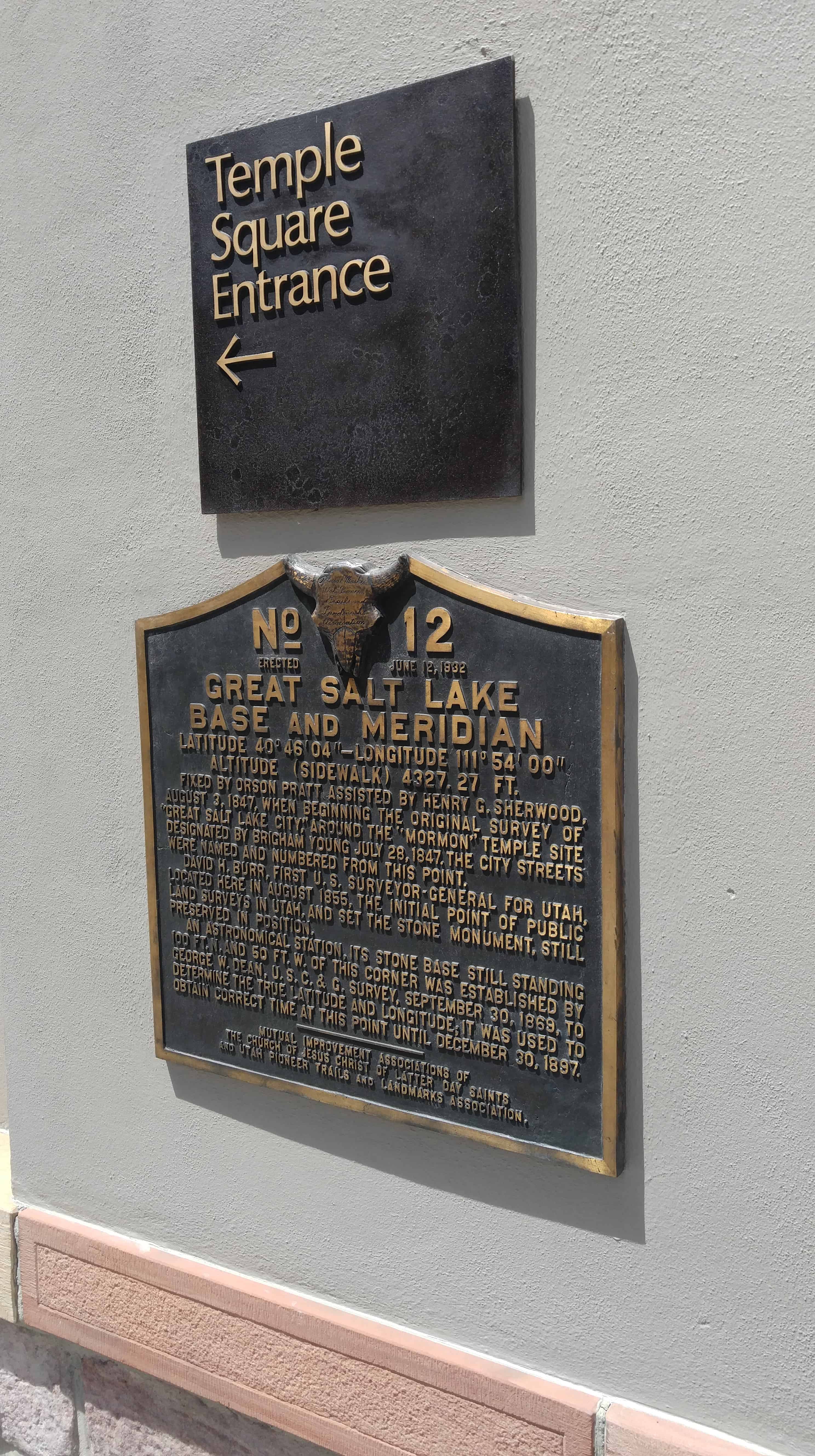
“An astronomical station, its stone base still standing 100 ft. N. and 50 ft. W. of this corner was established by George W. Dean, U.S.C.&G. survey, September 30, 1869, to determine the true latitude and longitude; it was used to obtain correct time at this point until December 30, 1897.” (from the plaque on for the Great Salt Lake Base and Meridian)

Marker Information


Placed By:Not Available
Date Placed:1869
Materials:Engraved in the stone
Marker Condition:Excellent
Monument Information


Constructed By:Not Available
Materials:Cut sandstone block
Dimensions (base):2′ Square
Condition:Excellent
Additional Information


Surveyor’s Name:Kate Wacker
Surveyor’s Organization:USHS
Date Surveyed:1995-11-14
2016-07-02-14-41-00

Great Salt Lake Base and Meridian

19 Monday Sep 2016

Posted by Jacob Barlow in Uncategorized

≈ 4 Comments

Tags

Benchmarks, Downtown SLC, historic, Salt Lake City, Salt Lake County, utah

2016-07-02-14-39-00

The Great Salt Lake Base and Meridian Monument and Plaque,  The stone was placed on August 3, 1847 when the original survey of “Great Salt Lake City” began.
The city streets were all surveyed and numbered from this point.

Fixed by Orson Pratt assisted by Henry G. Sherwood, August 3, 1847, when beginning the original survey of “Great Salt Lake City,” around the “Mormon” Temple site designated by Brigham Young July 28, 1847. The city streets were named and numbered from this point. David H. Burr, first U.S. Surveyor-General of Utah, located here in August 1855, the initial point of public land surveys in Utah, and set the stone monument, still preserved in position. An astronomical station, its stone base still standing 100 ft. N. and 50 ft. W. of this corner was established by George W. Dean, U.S.C.&G. survey, September 30, 1869, to determine the true latitude and longitude; it was used to obtain correct time at this point until December 30, 1897.

See other historic markers in the series on this page for UPTLA/SUP Markers.

2016-07-02-14-39-06

Engineering Department Standard of Measure

11 Sunday Sep 2016

Posted by Jacob Barlow in Uncategorized

≈ 2 Comments

Tags

Benchmarks, Downtown SLC, historic, Salt Lake, Salt Lake City, Salt Lake County, Survey

  • 2018-09-11 11.13.27

This survey marker lies in the sidewalk on the southeast corner of 400 South State Street in downtown Salt Lake City, Utah.

ENGINEERING DEPARTMENT
SALT LAKE CITY

STANDARD OF MEASURE

Under this cover lies a granite survey monument. It extends approximately six feet deep and is five feet square at the base. There is a similar monument one hundred feet and another one four hundred feet to the East of here. Salt Lake City Engineering set these monuments in the year 1895. They were used as the Standard of Measure for surveying the blocks and streets as they exist today.

This is located next to the DUP Marker for the Pioneer Camping Grounds on Washington Square.

2018-09-11 11.13.35
2016-06-25-15-49-31

    Benchmark: GR0066 “J160” Azimuth Mark

    25 Thursday Aug 2016

    Posted by Jacob Barlow in Uncategorized

    ≈ Leave a comment

    Tags

    Benchmarks, Clark County, historic, Nevada

    a88097c7-7f1c-40ca-9516-60280244d729

    Out exploring I found the Azimuth Mark for Benchmark: GR0066 “J160.”

    6d2116fc-c80b-400f-9ae0-62a2976030b0

    Maple Mountain / Spanish Fork Peak

    23 Tuesday Aug 2016

    Posted by Jacob Barlow in Uncategorized

    ≈ 7 Comments

    Tags

    Benchmarks, Hiking, Maple Mountain, Mapleton, spanish fork, Spanish Fork Peak, Springville, utah, utah county

    • picture08feb08-031
    • 88932049-2ef7-4f6d-885a-9c263e09f2e4

    Maple Mountain is above Mapleton and Spanish Fork, I grew up in Mapleton and hiked that mountain more times that I could count or remember.    It’s a gorgeous hike but a longer one, there’s a nice pond we call Maple Lake when you’re most of the way up and it’s a great place to stop for a while before finishing.

    The trail starts at the top of Whiting Campground, a quarter-mile after that you cross the creek to take trail 007 and can’t miss it from there.
    I’ve had the hike take 12 hours up and back many times including time to play in the lake and catch salamanders but when hurrying and when in Shape I’ve gone up in 2 hours and come back down about that quick.

    There’s plenty of wildlife and scenery and amazing views of the valley from the saddle (after the lake and before the top.)

    Growing up in Mapleton everyone I knew called it Maple Mountain, the same with those in Springville – but over in Spanish Fork I found out that most people called it Flonette.  We also called it Sierra Bonita (Beautiful Mountain) regularly.    The debate continues because the SF people insist it is Flonette and other insist Maple Mtn.    Local landmarks, schools, businesses and such are named for both Maple Mountain and Flonette so trying to use that as “proof” is futile and trying to look to real or official maps doesn’t work because all I’ve seen just identify the peak as Spanish Fork Peak but do not name the mountain.  I’ve also heard that in the 50’s and 60’s it was mostly called Front Mountain.

    Related posts:

    • Maple Mountain Trojan Fire 1994
    • 2018-03-05 13.37.43
    • cbd87d50-5b7f-4ffb-b811-ad8061c0d767

    Idaho Utah Wyoming Corner

    31 Tuesday May 2016

    Posted by Jacob Barlow in Uncategorized

    ≈ 3 Comments

    Tags

    Benchmarks, Cokeville, Coordinate Confluences, Corners, Idaho, Rich County, utah, Wyoming

    Several of my favorite things, a state corner (Utah/Idaho/Wyoming), a benchmark, and a coordinate confluence (a couple miles east, where the corner was “supposed” to be.

    06d6fb86-2aa0-4773-83c6-400543485897
    43aa5cf2-0da4-4523-a24a-9fdd909dfccb
    547891ab-6c4c-47fe-8034-4bbe384c2b09
    907134e5-fa3d-486a-9790-640d3183012f
    b359f784-a392-4cb4-938b-79ce31a125ac
    dfb02aa6-3073-46dd-a19b-b2b8341e4787
    eaf22f82-9ce4-401e-826b-f50fe147f34c
    f5e8444a-4a17-4036-9c3f-3c8b9e5d1f12
    f9d71478-4816-47ee-b3d3-fc45f933d130


    It was a bumpy Jeep ride to the corner, and a gorgeous day out there.  It was really easy to find the way from the Highway in Wyoming.


    Benchmark: KO0473 “SORENSON”

    20 Friday May 2016

    Posted by Jacob Barlow in Uncategorized

    ≈ Leave a comment

    Tags

    Benchmarks, Millard County, utah

    2016-03-06 16.00.56
    2016-03-06 16.01.06
    2016-03-06 16.01.41
    2016-03-06 16.01.48
    2016-03-06 16.02.38
    2016-03-06 16.02.50
    2016-03-06 16.09.13
    2016-03-06 16.09.22
    2016-03-06 16.09.30

    01/01/1957 by CGS (MONUMENTED)
    DESCRIBED BY COAST AND GEODETIC SURVEY 1957 (WRH) THE STATION IS LOCATED AIRLINE, ABOUT 8 MILES NORTH-NORTHEAST OF GARRISON AND ABOUT 8 MILES EAST-NORTHEAST OF BAKER, ALONG THE NORTH SIDE OF U.S. HIGHWAY 50 AND 6. THE STATION IS A STANDARD DISK STAMPED SORENSON 1957 SET IN TOP OF A 10-INCH SQUARE CONCRETE MONUMENT WHICH PROJECTS ABOUT 4 INCHES ABOVE THE GROUND. IT IS 108 FEET NORTH OF THE CENTER LINE OF THE HIGHWAY AND 12.5 FEET NORTH OF A WHITE WITNESS POST. REFERENCE MARK NUMBER ONE IS A STANDARD DISK STAMPED SORENSON NO 1 1957 SET IN TOP OF A 10-INCH SQUARE CONCRETE MONUMENT WHICH PROJECTS ABOUT 4 INCHES ABOVE THE GROUND AND IS ABOUT THE SAME ELEVATION AS THE STATION. IT IS 142 FEET NORTH OF THE CENTER LINE OF THE HIGHWAY. REFERENCE MARK NUMBER TWO IS A STANDARD DISK STAMPED SORENSON NO 2 1957 SET IN TOP OF A 10-INCH SQUARE CONCRETE MONUMENT WHICH PROJECTS ABOUT 5 INCHES ABOVE THE GROUND AND IS ABOUT THE SAME ELEVATION AS THE STATION. IT IS 96 FEET NORTH OF THE CENTER LINE OF THE HIGHWAY. THE AZIMUTH MARK IS A STANDARD DISK STAMPED SORENSON 1957 SET IN TOP OF A 10-INCH SQUARE CONCRETE MONUMENT WHICH PROJECTS ABOUT 4 INCHES ABOVE THE GROUND. IT IS 51 FEET SOUTH OF THE CENTER LINE OF THE HIGHWAY. TO REACH THE AZIMUTH MARK FROM THE STATION, GO EAST ON U.S. HIGHWAY 50 AND 6 FOR 0.8 MILE TO THE AZIMUTH MARK ON THE RIGHT, SOUTH SIDE. TO REACH THE STATION FROM THE POST OFFICE IN BAKER, GO NORTH ON STATE HIGHWAY 73 FOR 4.7 MILES TO THE JUNCTION WITH U.S. HIGHWAY 50 AND 6. TURN RIGHT AND GO EAST ON U.S. HIGHWAY 50 AND 6 FOR 10.7 MILES TO A WHITE WITNESS POST ON THE LEFT, NORTH SIDE AND THE STATION. HEIGHT OF LIGHT ABOVE STATION MARK 3.09 METERS.


    Benchmark: JO0413 “S 377 M CO”

    20 Friday May 2016

    Posted by Jacob Barlow in Uncategorized

    ≈ Leave a comment

    Tags

    Benchmarks, Millard County, utah

    Out benchmark hunting again.

    2016-03-06 14.53.28
    2016-03-06 14.53.32
    2016-03-06 14.53.48


    DESCRIBED BY NATIONAL GEODETIC SURVEY 1984 15.8 KM (9.8 MI) SE FROM GARRISON. 15.8 KM (9.85 MI) SOUTHEAST ALONG STATE HIGHWAY 21 FROM THE POST OFFICE AT GARRISON, IN THE SOUTHWEST CORNER OF THE INTERSECTION OF A TRACK ROAD, 0.8 KM (0.5 MI) SOUTHEAST OF THE T JUNCTION OF BURBANK ROAD, 21.3 METERS (70 FT) SOUTHWEST OF THE HIGHWAY CENTERLINE, 8.3 METERS (27.5 FT) SOUTH OF THE CENTER OF THE ROAD AND 7.3 METERS (24 FT) SOUTHWEST OF THE WEST POLE FOR A TELEGRAPH LINE CROSSING. THE MARK IS 0.5 METERS NE FROM A WITNESS POST. THE MARK IS 1.0 M BELOW THE HIGHWAY.

    Mormon Gap

    20 Friday May 2016

    Posted by Jacob Barlow in Uncategorized

    ≈ Leave a comment

    Tags

    Antelope Valley, Beaver County, Benchmarks, Mormon Gap, Snake Valley, utah

    Mormon Gap is the gap in the Burbank Hills to travel between Snake Valley and Antelope Valley.  We were out hunting Benchmarks and stopped to find the one named for Mormon Gap.

    The views of the valleys were great but a storm was hitting so we didn’t stick around long.

    2016-03-06 15.29.24

    Benchmark: JO0456 ‘6443 FEET’

    18 Thursday Feb 2016

    Posted by Jacob Barlow in Uncategorized

    ≈ 1 Comment

    Tags

    Beaver County, Benchmarks, Frisco, historic

    Out benchmark hunting and found Benchmark: JO0456 ‘6443 FEET’.

    4ac90111-e443-4458-ad2c-028d33bfa547
    663a3584-c766-4f13-ba1f-2fd513fe567b
    70007343-3efa-46d4-8127-d999c0b5d786


    N 38° 27.143 W 113° 15.579

    This U.S. Geological Survey Disc is near the Ghost town of Frisco, Utah and D.U.P. Marker #268.


    ← Older posts
    Newer posts →

    Follow Jacob

    Follow Jacob

    Come wander with me on Youtube.

    Blog Stats

    • 2,100,700 hits

    Social and Other Links

    BarlowLinks.com

    Recent Posts

    • Scout Monument
    • Provo High School Seminary Building
    • 821 E 100 S
    • 820 E 100 S
    • 817-819 E 100 S

    Archives

    Loading Comments...