• About JacobBarlow.com
  • Cemeteries in Utah
  • D.U.P. Markers
  • Doors
  • Exploring Utah Email List
  • Geocaching
  • Historic Marker Map
  • Links
  • Movie/TV Show Filming Locations
  • Oldest in Utah
  • Other Travels
  • Photos Then and Now
  • S.U.P. Markers
  • U.P.T.L.A. Markers
  • Utah Cities and Places.
  • Utah Homes for Sale
  • Utah Treasure Hunt

JacobBarlow.com

~ Exploring with Jacob Barlow

JacobBarlow.com

Tag Archives: DUP

Bear River City Fort

15 Monday Nov 2021

Posted by Jacob Barlow in Uncategorized

≈ Leave a comment

Tags

Bear River City, Box Elder County, DUP, Forts, Historic Markers, utah

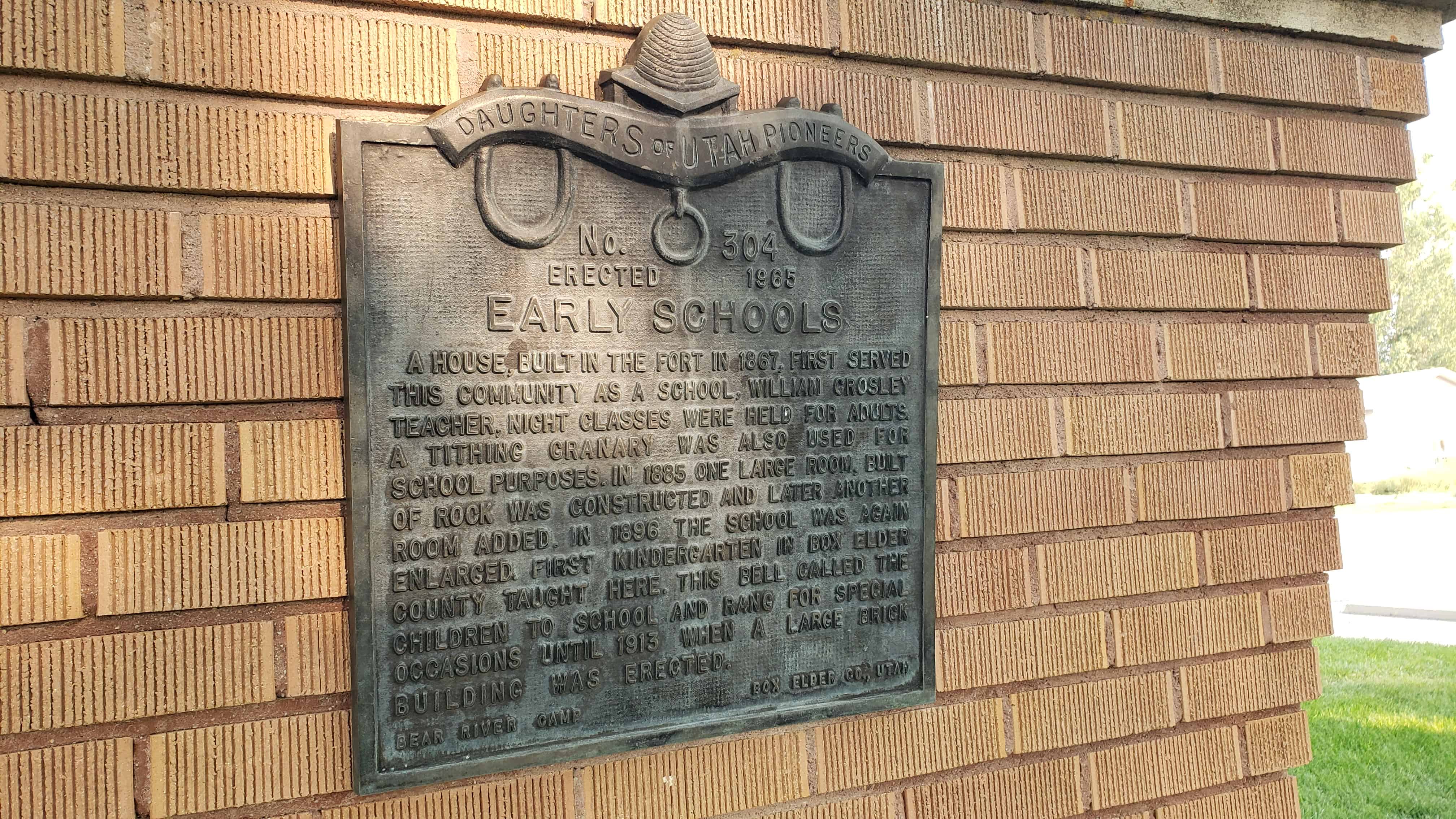
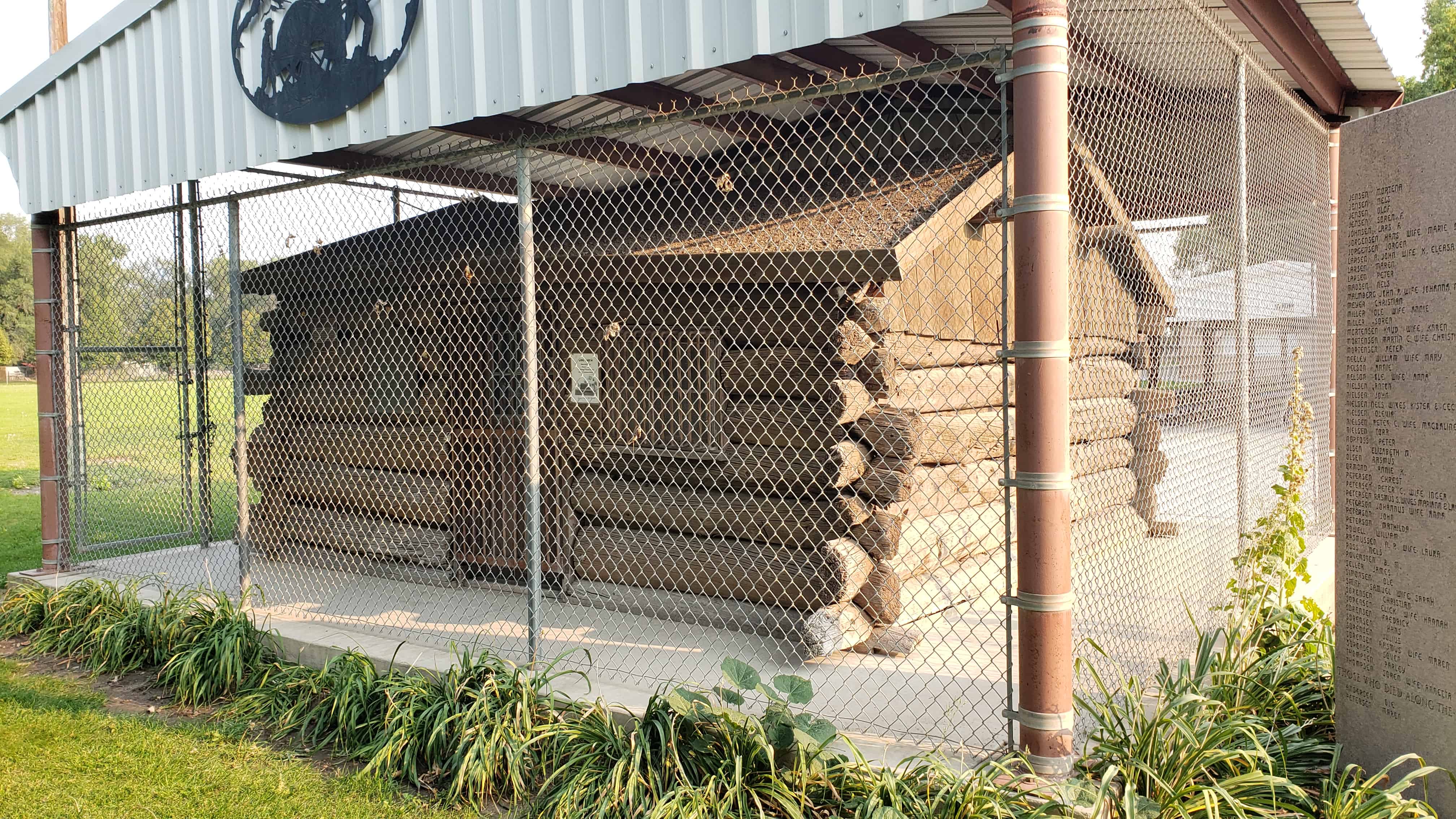
In 1866 a group of Scandinavian Latter-day Saints entered the area that would become Bear River City. Their first homes were dugouts on the west bank of the Bear River. These dugouts were roofed with poles, willows, straw, and dirt. The fall of 1867 saw these early pioneers moving from the river dugouts to establish the Bear River Fort as a protection from the Indians. The fort was built on this ten acre block with log and adobe cabins surrounding the entire area.

The doors and windows of all 44 cabins in the fort face the center, making the cabin walls the walls of the fort. In the center area, they erected a flagpole on which Old Glory was unfurled, not only on state occasions, but to call the people to church, the children to school, or as a signal that the cow herd was ready to start for the pasture.

On three corners of the fort, wells were dug for the water supply, and the animals were corralled outside the fort. A house for public gatherings was erected on the west wall where church, school, dances, and meetings were held. Irrigation from the Malad River was introduced when the area northwest of the fort was farmed.

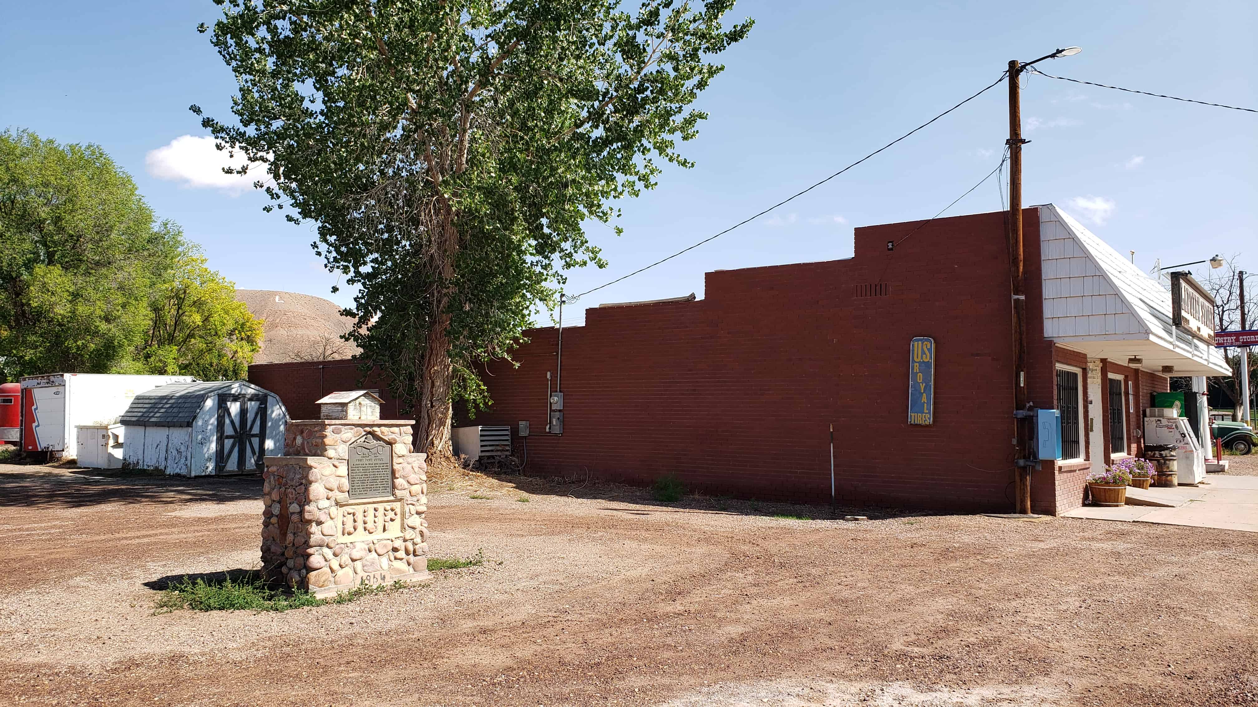
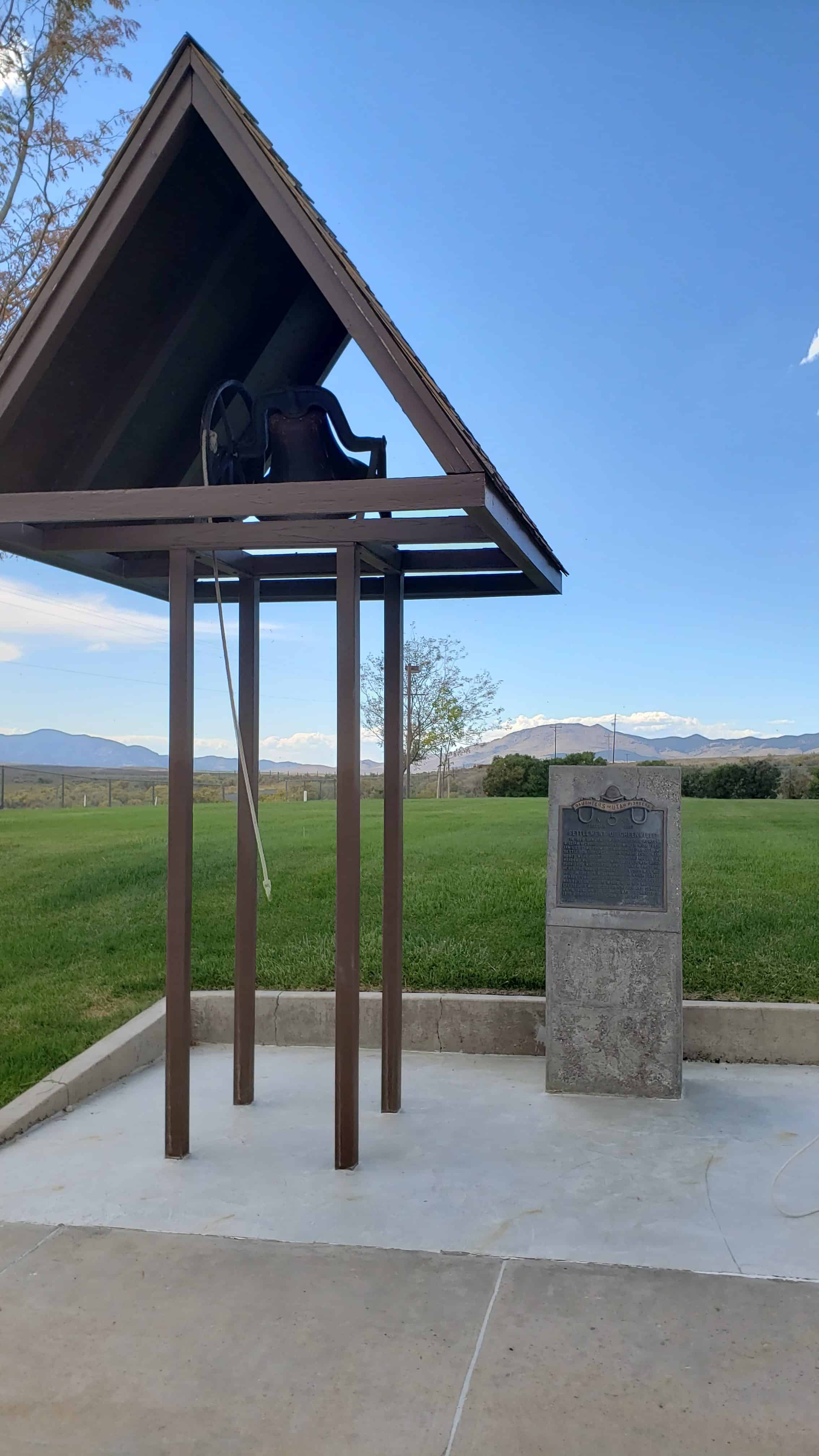
This is DUP Marker #496 located at Bear River City Park at 4470 West 5900 North in Bear River City, Utah

Related:

  • DUP Markers

First Post Office

05 Friday Nov 2021

Posted by Jacob Barlow in Uncategorized

≈ 1 Comment

Tags

DUP, Historic Markers, Lapoint, Uintah County, utah

First Post Office

In August 1905 the Uintah Indian Reservation was opened to white settlers who came and built homes. They organized Whiterocks Irrigation Company, built a canal and raised crops. In 1908 a post office and store was built at Taft, one mile south of here by Maylus E. Sprouse who was the first postmaster. Roy Warburton carried the mail from Vernal on horseback, making three trips each week and Warren Ross carried mail to and from Fort Duchesne. In 1915 the settlement of Taft was moved and renamed Lapoint.

This historic marker is #300 by the D.U.P., located at the Lapoint Store at 109800 East 7000 North (Highway 121) in Lapoint, Utah.

Related:

  • DUP Markers

The back side of the monument has this plaque:

First Things of Lapoint

The Reservation was thrown open for homesteading in August 1905

First Settlers

James Harrison built a log cabin on the bank of Deep Creek and moved his family there on the 13th of Mar 1906. Harmon Mullins and William Sprouse also built one room log and lumber cabins on their homesteads and moved their families in on the 18th of April 1906. Grandma Daniels (six miles away) was their closest and only neighbor Archie Lee Searle (Headstone below) was the first grave to be placed in the Lapoint Cemetery

Completed Sept 10th 1965
Dedicated Nov 7th 1965
Built and dedicated by J. M. Rasmussen

Father Archie Lee Searle
1880 — 1918

Pioneers of Antimony

04 Thursday Nov 2021

Posted by Jacob Barlow in Uncategorized

≈ Leave a comment

Tags

Antimony, DUP, Garfield County, Historic Markers, utah

Pioneers of Antimony

In 1873, Albert Guiser and others located in a fertile meadow which they named Grass Valley. Surveyors camped on a stream, lassoed a young coyote and called the place Coyote Creek. The first L.D.S. settlers were Isaac Riddle and family who took up land on the east fork of the Sevier River. Later a school house was built, and the Marion Ward organized with Culbert King as Bishop. In 1920 the name was officially changed to Antimony after the antimony mines east of the valley.

This is D.U.P. historic marker #137, located at 160 E Center Street (Highway 22) in Antimony, Utah

Related:

  • DUP Markers

Early Schools

02 Tuesday Nov 2021

Posted by Jacob Barlow in Uncategorized

≈ Leave a comment

Tags

Bear River City, Box Elder County, DUP, Historic Markers, utah

A house, built in the fort in 1867, first served this community as a school, William Crosley teacher. Night classes were held for adults. A tithing granary was also used for school purposes. In 1885 one large room, built of rock was constructed and later another room added. In 1896 the school was again enlarged. First kindergarten in Box Elder County taught here. This bell called the children to school and rang for special occasions until 1913 when a large brick building was erected.

This is DUP Marker #304 located at Bear River City Park at 5810 North 4800 West in Bear River City, Utah

Related:

  • DUP Markers

Bear River City

01 Monday Nov 2021

Posted by Jacob Barlow in Uncategorized

≈ Leave a comment

Tags

Bear River City, Box Elder County, Cabins, DUP, Historic Markers, museums, utah

In 1866, a group of Mormon Scandinavians were called by the Latter-day Saints Church to establish this settlement and develop an irrigation project from the waters of the Malad River. Their first homes were dug-outs built in the west bank of the Bear River north of the steel bridge, which now spans the river. In the fall of 1867, they built homes in a fort for protection from the Indians. This cabin was built there by Lars C. Christensen and his wife, Christiane, handcart pioneers of 1859.

This is DUP Marker #99 located at Bear River City Park at 4549 West 5900 North in Bear River City, Utah

Related:

  • DUP Markers

Settlement of Greenville

21 Thursday Oct 2021

Posted by Jacob Barlow in Uncategorized

≈ Leave a comment

Tags

Beaver County, DUP, Greenville, historic, Historic Markers, utah

Settlement of Greenville

In 1860 Samuel Edwards, George Horton, William Richards and David Miller with their families came from Parowan and Cedar City and settled Dry Creek. Soon others followed. Homes were built of logs, rock, and adobe. The meadows were covered with lush growth which furnished winter feed and summer pasture, hence the name of “Greenville.” A grist mill was built in 1865 by William Barton which served nearby communities. The first log school house was built on the site where a church was later erected. It was used for church and school until 1906. An L.D.S. Ward was organized in 1872 with Robert Easton as Bishop.

This is D.U.P. Historic Marker #243 (see others in the series on this page) located at 480 West Main Street in Greenville, Utah

Uintah Stake Tabernacle

27 Monday Sep 2021

Posted by Jacob Barlow in Uncategorized

≈ Leave a comment

Tags

DUP, Historic Markers

The Unitah Stake Tabernacle was built from 1898-1907 under the direction of Uintah Stake President Samuel R. Bennion and counselors Reuben S. Collett and James P. Hacking. The architect was T.T. Davies with William Cook as the builder. Fathers and sons toiled long days and nights with primitive tools. Logs were hauled from nearby canyons; bricks were made locally by Swain Brothers; pine woodwork was painted and combed to look like oak; pillars were painted to look like marble. Of modest construction, the building featured stone window heads and sills, arched vestibules, a U-shaped gallery, and a simple cupola crowned the roof. The total cost was $37,000.

Invited by Stake President William H. Smart, Church President Joseph F. Smith dedicated the Tabernacle on August 24, 1907. Crowds filled the building for two days of services. Children sang and recited the Articles of Faith.

The building was used as a meeting house and stake tabernacle until 1949 when a new stake center was built. The original building was used thereafter until 1984 as a cultural center, political hall, and the scene of many spiritual events. On February 13, 1994, after the building had been vacant for several years, the First Presidency announced that it would be converted into a temple for use by the Latter-day Saints in the Vernal area.

This page is for the D.U.P. historic marker about the Uintah Stake Tabernacle, the marker is outside the DUP Museum which is the old tithing office located at 186 South 500 West in Vernal, Utah, see this page for the Uintah Stake Tabernacle/Vernal Utah Temple itself.

Related:

  • DUP Markers
  • Vernal Utah Temple

First Tithing Office

27 Monday Sep 2021

Posted by Jacob Barlow in Uncategorized

≈ Leave a comment

Tags

DUP, Historic Markers

This rock building was erected in 1887 by Uintah Stake of the L.D.S. Church on ground contributed by Jeremiah Hatch Sr. for $1.00. Men hauled rock from which Harley Mowery and John Jacob Slaugh, experienced stone masons, constructed this office. The building was laid out by the north star. For many years the church members paid their tithing here. Which was one tenth of their increase in money or produce. The proceeds were used for general church purposes.

This page is for the D.U.P. historic marker on the tithing office that is located at 186 South 500 West in Vernal, Utah, see this page for the building itself.

Related:

  • DUP Markers
  • Vernal DUP Museum
  • Vernal Tithing Office

Utah Civil War Casualty

20 Friday Aug 2021

Posted by Jacob Barlow in Uncategorized

≈ 1 Comment

Tags

Civil War, DUP, Historic Markers, Salt Lake City, War Memorials

Utah Civil War Casualty

Lieutenant Henry Wells Jackson (March 10, 1827- May 27, 1864), was the only Utah battle fatality of the Civil War and the first known Latter-Day Saint to be killed in a U.S. national conflict. Jackson marched in the Mormon Battalion, Company D, musician; panned for gold at Mormon Island (now Folsom Lake), California; and used gold to pay for his wedding. He and Eliza Ann Dibble were married in Salt Lake on February 3, 1850, by Brigham Young. Henry and Eliza started a family and helped establish settlements in Tooele Valley and San Bernardino, California. In 1858, Henry carried mail for George Chorpenning on the Overland Mail Route, a precursor to the Pony Express. Due to bad management, Henry was owed $1,300 in back pay for his mail service. He decided to go back East to try and collect the money. Payment was delayed, so Henry took employment as a wagon master and was ultimately captured by the Confederate Army and held as a prisoner for three months. He was later released in exchange for Confederate prisoners. Because of the way he was treated, he decided to fight for the Union. Henry enlisted with the First Regiment, District of Columbia, Volunteer Cavalry and was commissioned as a lieutenant due to his previous service in the Mormon Battalion. On May 8, 1864, Henry took part in the Battle of White Bridge near Jarrett’s Station, Virginia, and was shot. Due to infection, he died on May 27, 1864, leaving behind his wife and three children. Henry Wells Jackson is buried in Hampton National Cemetery and is remembered for his great sacrifice and love for family and country.

This is DUP Marker #576 (see others here) located on the grounds of the State Capitol Building and on the same monument as DUP Marker #270.

Willard Pioneer Cemetery

27 Tuesday Jul 2021

Posted by Jacob Barlow in Uncategorized

≈ 1 Comment

Tags

Box Elder County, DUP, Historic Markers, utah, Willard

The Willard Pioneer Cemetery’s first burial was August 1854 with the death of five-day-old John Memorial, Jr., son of John Memorial (Memory) and Samantha Wells McCrary. This site, selected by Willard’s first settlers, is located one block east of the first group of log houses erected in Willard in 1851.

The McCrary baby was buried in the southwest corner of the the cemetery. Subsequent burials were north of this gravesite in order of the date of death. Loved ones were not buried by their families unless death immediately followed the last burial. For this reason, a new cemetery was chosen in 1869 on the foothills north of the original location. One hundred and fifty settlers were buried in this cemetery, and one hundred ten burials have been documented. Names of the other forty are being sought. That last known burial in this cemetery was in 1905.

The Willard flood of 1923 devastated this hallowed site. Floodwaters, cutting a large trench, caused markers and some remains of the graves to be washed into the field west of town. Located remains were brought back to the cemetery and buried in a common grave. Headstones and markers were replaced as accurately as possible.

This is D.U.P. Historic Marker #507 located in Willard, Utah

← Older posts
Newer posts →

Follow Jacob

Follow Jacob

Come wander with me on Youtube.

Blog Stats

  • 2,100,051 hits

Social and Other Links

BarlowLinks.com

Recent Posts

  • Scout Monument
  • Provo High School Seminary Building
  • 821 E 100 S
  • 820 E 100 S
  • 817-819 E 100 S

Archives

Loading Comments...