• About JacobBarlow.com
  • Cemeteries in Utah
  • D.U.P. Markers
  • Doors
  • Exploring Utah Email List
  • Geocaching
  • Historic Marker Map
  • Links
  • Movie/TV Show Filming Locations
  • Oldest in Utah
  • Other Travels
  • Photos Then and Now
  • S.U.P. Markers
  • U.P.T.L.A. Markers
  • Utah Cities and Places.
  • Utah Homes for Sale
  • Utah Treasure Hunt

JacobBarlow.com

~ Exploring with Jacob Barlow

JacobBarlow.com

Tag Archives: historic

Pipe Spring National Monument

22 Wednesday Mar 2017

Posted by Jacob Barlow in Uncategorized

≈ 1 Comment

Tags

Arizona, Forts, historic, Historic Markers, LDS, Mohave County, National Monuments, Pipe Spring, Springs

2017-03-05 09.36.00

UPTLA (SUP) Marker #5 at Pipe Spring National Monument.

PIPE SPRINGS NATIONAL MONUMENT, Established May 31, 1923, through efforts of Stephen T. Mather and friends. PIPE SPRINGS, occupied in 1863, by Dr. James M Whitmore, who, with Robert McIntire was killed 4 miles S.E. of Pipe Springs January 8, 1866, by Navajo and Piute Indians.
WINDSOR CASTLE Erected by direction of Brigham Young in 1869 – 70 by Anson Windsor for handling the Church tithing herds and as a frontier refuge from Indians. It became the first telegraph office in Arizona when the Deseret Telegraph Line reached here in December 1871.

See other historic markers in the series on this page for UPTLA/SUP Markers.

2017-03-05 09.35.04

2017-03-05 09.35.23

The Historic Dixie-Long Valley, Utah Pioneer Trail

18 Saturday Mar 2017

Posted by Jacob Barlow in Uncategorized

≈ 1 Comment

Tags

historic, Historic Markers, Hurricane, SUP, utah, Washington County

2017-03-05 08.35.00

SUP Marker #118 in Hurricane.  (Also located here is #101B)

Segments of the old Indian trails between St. George and Long Valley were used by Mormon pioneers to settle Long Valley in 1864 and for its resettlement in 1871 following Indian conflicts. This trail scaled the Hurricane Fault on the Johnson Twist. One segment went south from Virgin City and then east and the other went east to Rockville-Crafton and then south to Big Plains where they merged. The desert trail, about 85 miles long, traversed deep sand, sandstone ledges and lava faults and was the primary transportation route, including mail and heavy freight, for half a century. It took four days for loaded wagons drawn by horse or ox teams to travel the distance.

See other historic markers in the series on this page for SUP Markers.

2017-03-05 08.35.06

2017-03-05 08.35.48
2017-03-05 08.35.39
2017-03-05 08.35.26
2017-03-05 08.35.13

The Historic Hurricane Canal

18 Saturday Mar 2017

Posted by Jacob Barlow in Uncategorized

≈ 1 Comment

Tags

Canals, historic, Historic Markers, Hurricane, La Verkin, SUP, utah, Washington County

2017-03-05 08.35.00

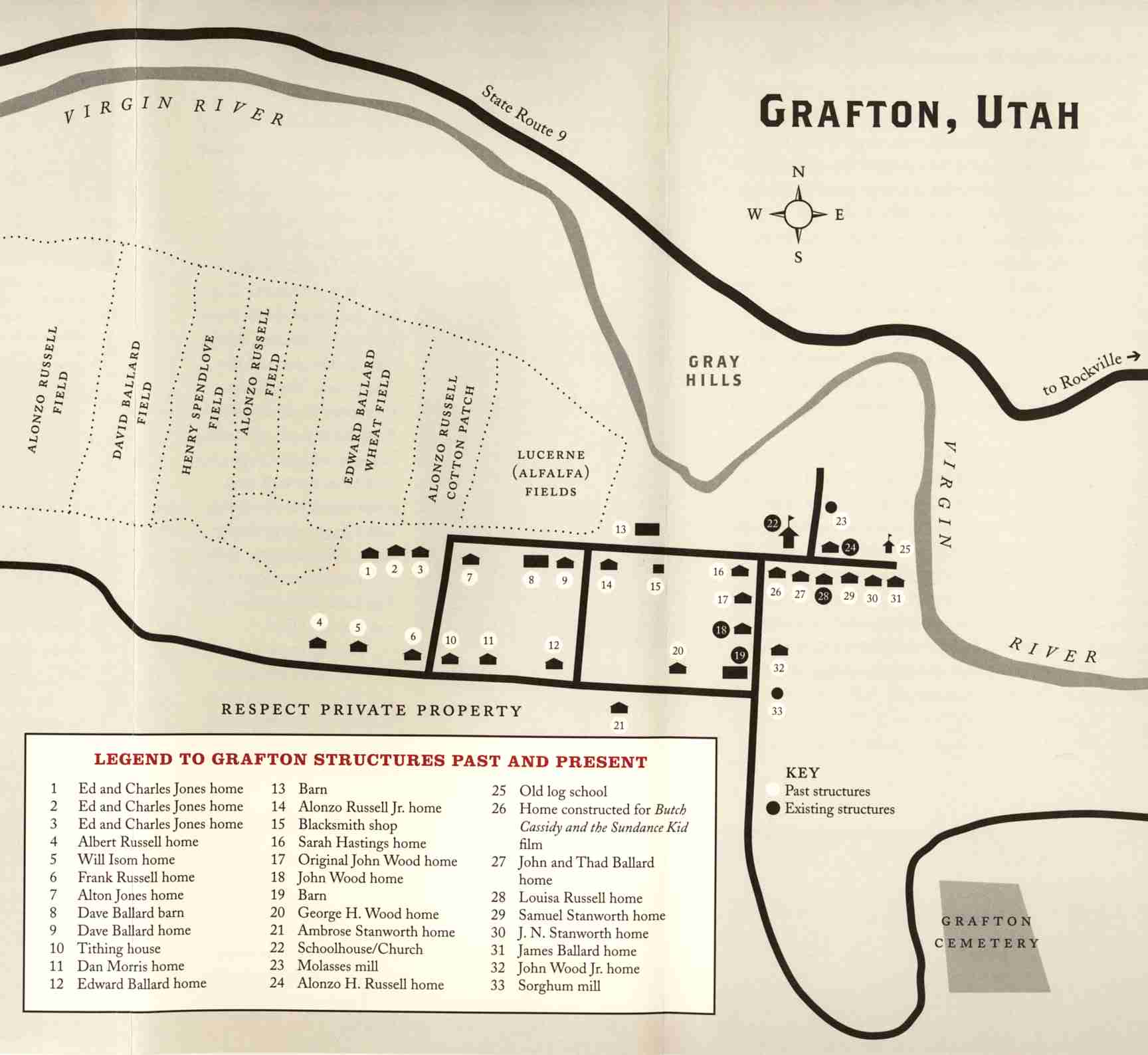
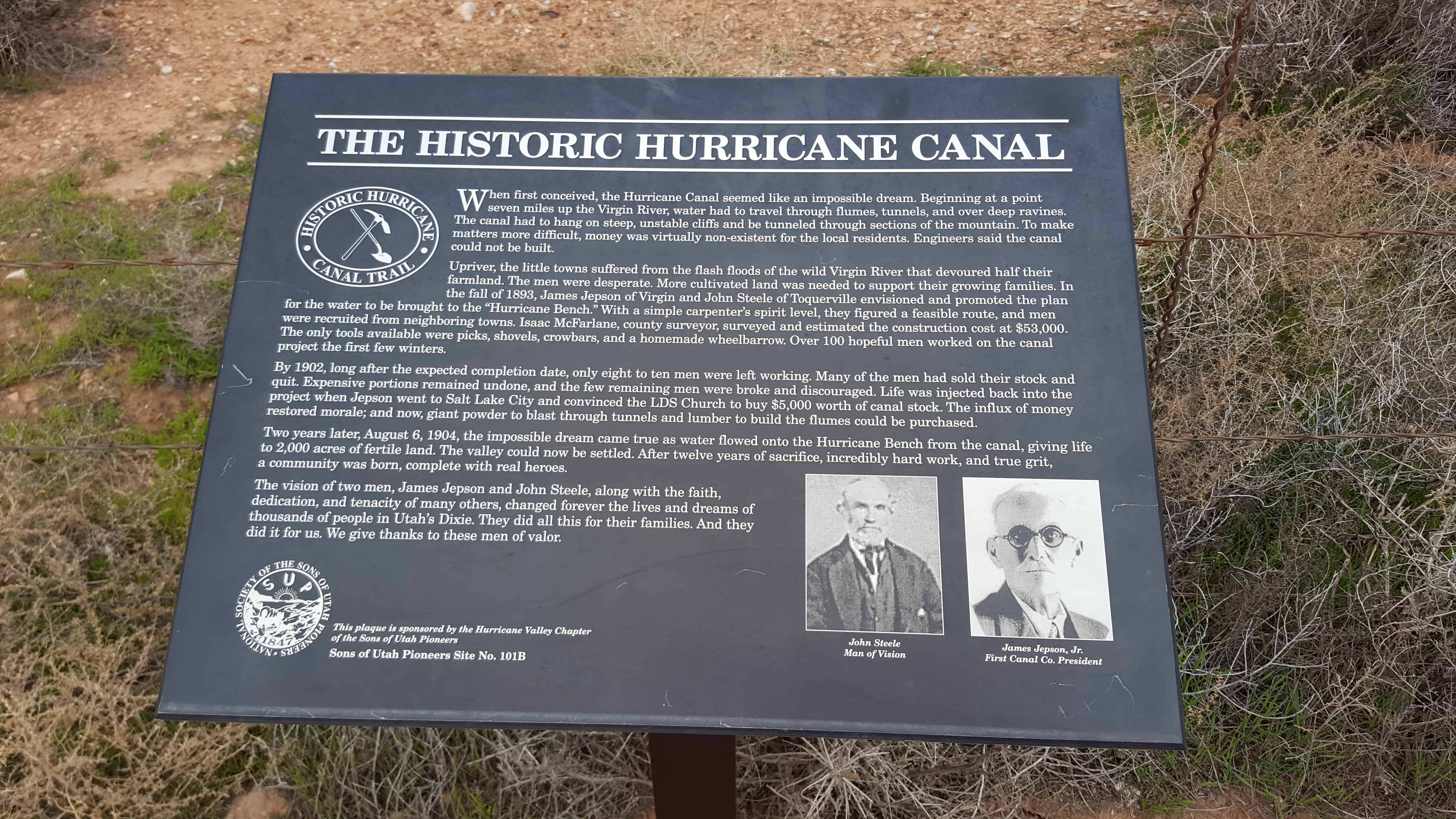
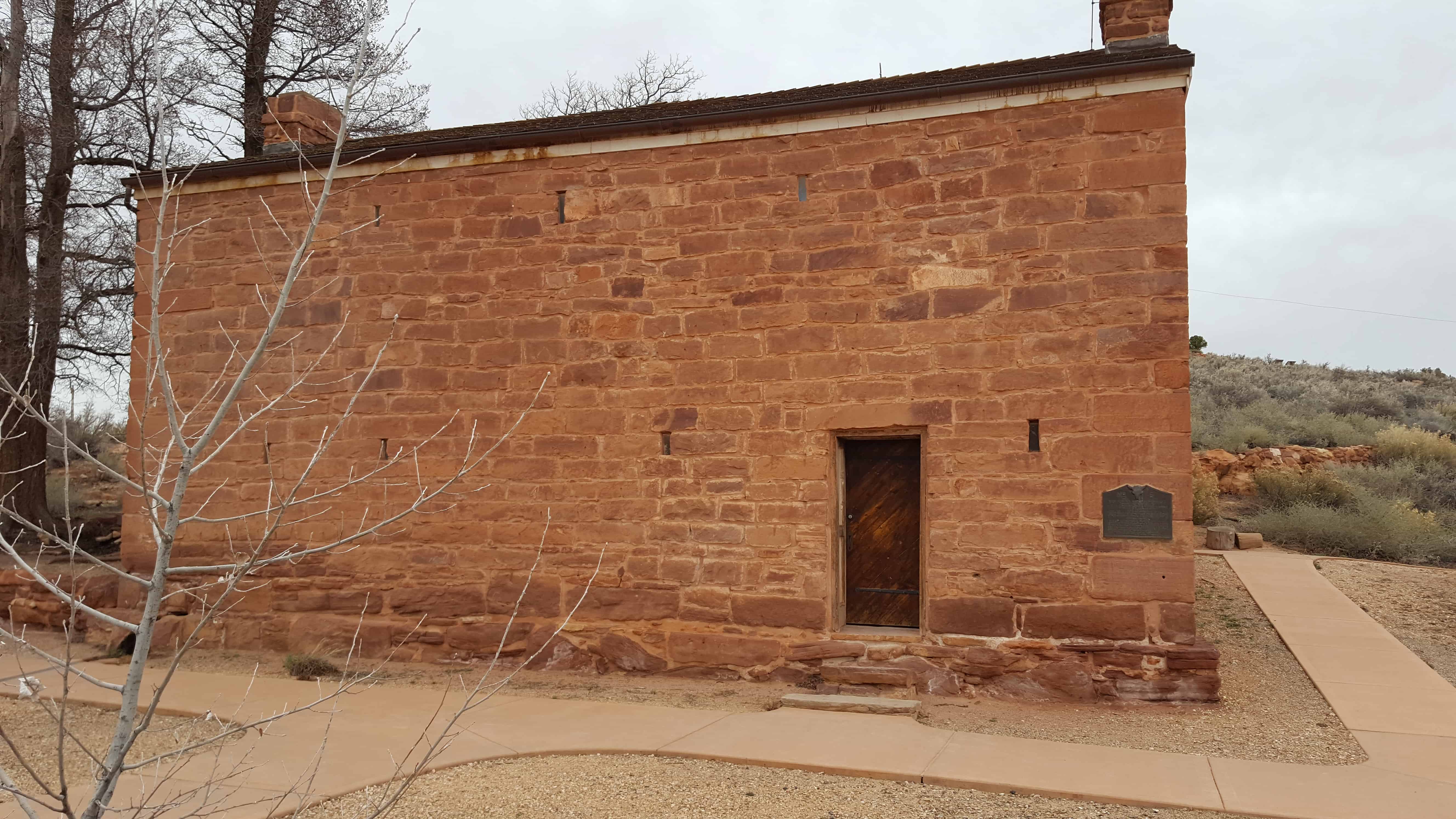
SUP Marker # 101B in Hurricane. (Also located here is #118)

When first conceived, the Hurricane Canal seemed like an impossible dream. Beginning at a point seven miles up the Virgin River, water had to travel through flumes, tunnels, and over deep ravines. The canal had to hang on steep, unstable cliffs and be tunneled through sections of mountain. To make matters more difficult, money was virtually non-existent for the local residents. Engineers said the canal could not be built.

Upriver, the little towns suffered from the flash floods of the wild Virgin River that devoured half their farmland. The men were desperate. More cultivated land was needed to support their growing families. In the fall of 1893, James Jepson of Virgin and John Steele of Toquierville envisioned and promoted the plan for the water to be brought to the “Hurricane Bench.” With a simple carpenter’s spirit level, they figured a feasible route, and men were recruited from neighboring towns. Isaac McFarlane, county surveyor, surveyed and estimated the construction cost at $53,000. The only tools available were picks, shovels, crowbars, and a homemade wheelbarrow. Over 100 hopeful me worked on the canal project the first few winters.

By 1902, long after the expected completion date, only eight to ten men were left working. Many of the men had sold their stock and quit. Expensive portions remained undone, and the few remaining men were broke and discouraged. Life was injected back into the project when Jepson went to Salt Lake City and convinced the LDS Church to buy $5,000 worth of canal stock. The influx of money restored morale; and now, giant powder to blast through tunnels and lumber to build the flumes could be purchased.

Two years later, August 6, 1904, the impossible dream came true as water flowed onto the Hurricane Bench from the canal, giving life to 2,000 acres of fertile land. The valley could now be settled. After twelve years of sacrifice, incredibly hard work, and true grit, a community was born, complete with real heroes.

The vision of two men, James Jepson and John Steele, along with the faith, dedication, and tenacity of many others, changed forever the lives and dreams of thousands of people in Utah’s Dixie. They did all this for their families. And they did it for us. We give thanks to these men of valor.

See other historic markers in the series on this page for SUP Markers.

2017-03-05 08.35.13

2017-03-05 08.35.48
2017-03-05 08.35.39
2017-03-05 08.35.26
2017-03-05 08.35.13
2017-03-05 08.35.06

Duncan’s Retreat

17 Friday Mar 2017

Posted by Jacob Barlow in Uncategorized

≈ 2 Comments

Tags

Duncan's Retreat, Ghost Towns, Grafton, historic, Rockville, utah, Washington County

2017-03-04 16.44.46

Historic taken from wchsutah.org

Chapman Duncan, Alma Minnerly, and a few others settled this area in 1861. But a flood in January of 1862 washed away much of the good farmland. Most of the first settlers moved away and sold their claims to William Theobald, Joseph Wright, William Wright, Clayborne Elder, Jonathan B. Pratt, Robert W. Reeve, and Thomas Burgess. Other settlers moved into the area and formed the village of Duncan’s Retreat.

There are several theories about the origin of the name, Duncan’s Retreat. One of them is that the name came the idea that Chapman Duncan had retreated from this area. Another is that Duncan retreated to this area after botching a canal surveying job in Virgin.

Farming produced good crops of cotton, corn, wheat, and sorghum.

A post office was built in 1863 and a schoolhouse in 1864. They also built an L.D.S. meetinghouse.

In 1866, when the Black Hawk War caused widespread fear of Indian attacks, the town was evacuated to Virgin, although farmers returned to Duncan’s Retreat each day to work their fields. Residents moved back permanently in 1868.

The Duncan’s Retreat settlement was all but abandoned in 1891. By 1930, hardly a trace remained – only a few foundations and trees.

2017-03-04 16.44.32

Population

  • About 70 at the end of 1862
  • 50 in 1864
  • There were 11 families and 79 people in 1880
  • There were 9 families in 1890
  • The village was all but abandoned in 1891

L.D.S. Church History

  • William Theobald was Presiding Elder between 1864 and 1866.
  • William Martindale was Presiding Elder starting in 1868.
  • Joseph Wright was Presiding Elder and/or Branch President until he died in 1873.
  • The Duncan Branch of the Virgin Ward was formed in 18?? and continued until about 1891.
  • Samuel Stansworth was Branch President starting in 1873.
  • Moses W. Gibson was the next Branch President.
  • David B. Ott was the next Branch President.

Discovery of Zion Canyon

16 Thursday Mar 2017

Posted by Jacob Barlow in Uncategorized

≈ Leave a comment

Tags

DUP, historic, Historic Markers, LDS Church, Springdale, utah, Washington County, Zion Canyon

2017-03-04 16.21.14

DUP Marker # 42 in Springdale.

In 1858, Nephi Johnson, one of Brigham Young’s scouts, with a party of Indian guides arrived at the mouth of the canyon. Due to superstition, the Indians refused to enter the canyon. Nephi Johnson, alone, followed up river to the Narrows, a place “where the sun is seldom seen,” returning to the mouth at nightfall. Isaac Buhannin, an early settler, seeing the spires remarked, “surely this is God’s first temple and should be called Zion.” William Heaps helped to build homes for the early settlers in the canyon.

2017-03-04 16.21.09

Rockville Bridge

16 Thursday Mar 2017

Posted by Jacob Barlow in Uncategorized

≈ 1 Comment

Tags

Bridges, historic, NRHP, Rockville, utah, Washington County


2017-03-04 14.53.54
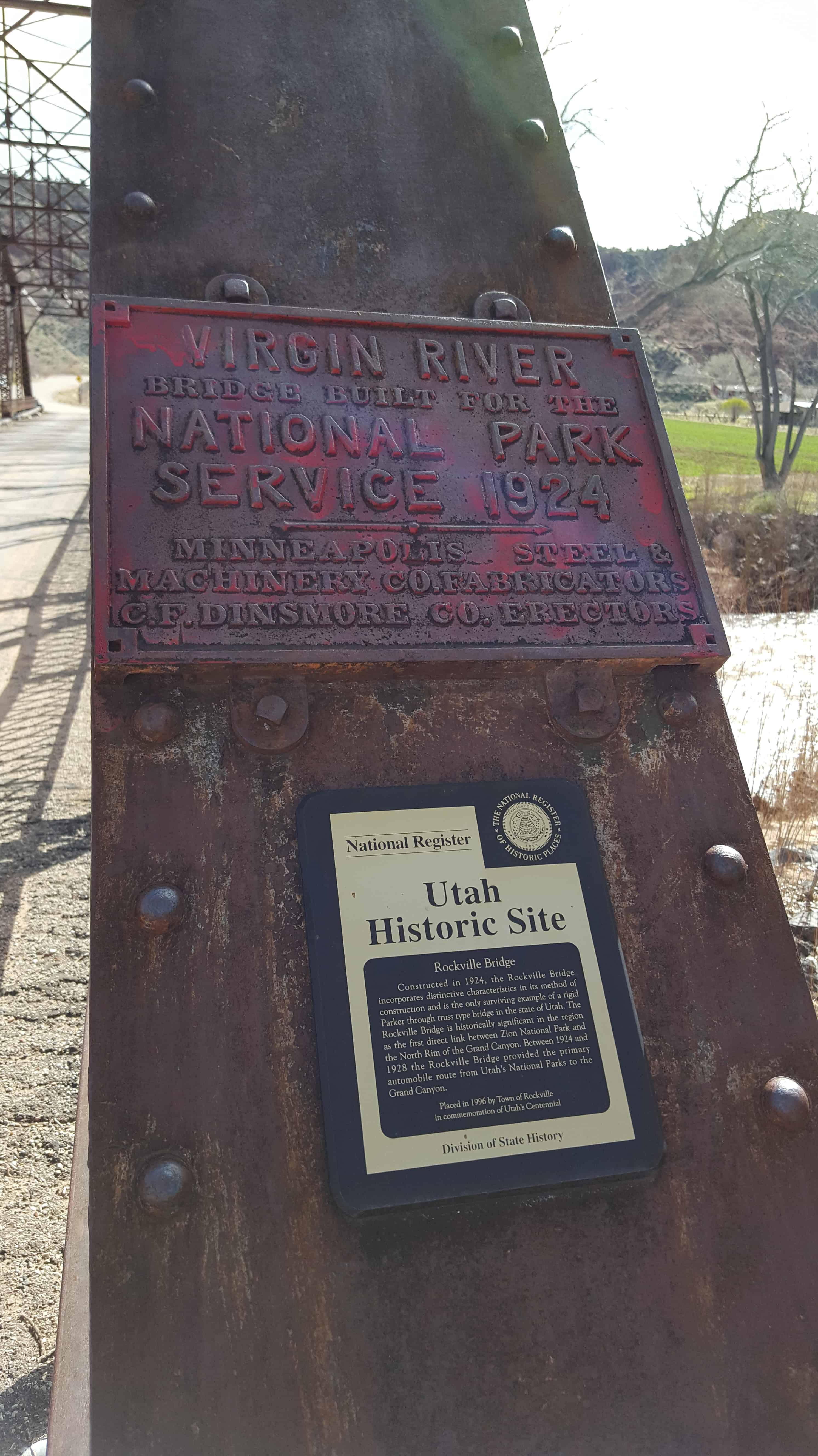
The Rockville Bridge spans the east fork of the Virgin River in Rockville. The bridge was built for the National Park Service in 1924 to provide a link between Zion National Park and the North Rim area of Grand Canyon National Park. The new bridge allowed motorists to take a circular tour of the national parks in southern Utah and northern Arizona. The Rockville route was superseded in 1928 by the construction of the Zion-Mount Carmel Highway.

The bridge was designed by the U.S. Bureau of Public Roads for the Park Service, fabricated by the Minneapolis Steel and Machinery Company, and erected by Ogden contractor C.F. Dinsmore. The bridge spans 217 feet in a single span, using a steel twelve-panel Parker through-truss.

The Rockville Bridge was placed on the National Register of Historic Places on August 4, 1995.

2017-03-04 14.54.11

2017-03-04 15.02.44
2017-03-04 14.57.28
2017-03-04 14.56.28
2017-03-04 14.56.23
2017-03-04 14.54.56
2017-03-04 14.54.49
2017-03-04 14.54.16
2017-03-04 14.54.11
2017-03-04 14.53.54
2017-03-04 14.53.47

Grafton Cemetery

15 Wednesday Mar 2017

Posted by Jacob Barlow in Uncategorized

≈ 1 Comment

Tags

Cemeteries, Ghost Towns, Grafton, historic, Rockville, Washington County

2017-03-04 13.28.30

In 1862 John W., William, Robert and Joseph Berry with their families, were called to help colonize the St. George area. In the spring of 1866, Joseph and Robert Berry with Isabelle Hales Berry, the latter’s wife, were returning from a trip to Salt Lake City. They stopped at Kanarraville and while there the two-year-old baby girl of Robert and Isabelle died. The Berrys resumed their journey, traveling in a light wagon, camping for noon, April 2, 1866, at Short Creek, where they were attacked by Piutes, who it is claimed had been following them from Corn Creek in Millard County.

Their dead bodies were found several days later by John and William Berry. The details of the tragedy will never be known. It appears that they attempted to escape by running their horses across the country and finding they could not do so, fought desperately for their lives, but in vain. One dead Indian was found nearby. Joseph was found lying face down in the wagon box; his leg had been bandaged, no doubt, while they were fleeing as fast as they cold from the Indians. Isabelle had been shot through the head with a six-shooter and was lying on the ground, while Robert’s body was astride the wagon tongue with the head leaning into the wagon. The Indians said afterward that Robert was a “heap brave fighter.”

Robert and Joseph were large men, tall of stature. The burial of these pioneers took place at Grafton, Utah. In Church Chronology it is recorded that this massacre occurred four miles from Maxfield’s Ranch on Short Creek, Kane County, Utah. There is a small knoll between Short Creek and Kane Beds which marks the place and is called Berry Knoll. When President Young heard of this outrage on the part of the Indians, he sent word to Cedar City for the men of that place to form a company of militia and go to Berryville and escort the people back to Dixie. The late John Parry of Cedar City was a member of that escort, and furnished the writer much of the information for this sketch.(*)

2017-03-04 13.26.19

Grafton, Utah

10 Friday Mar 2017

Posted by Jacob Barlow in Uncategorized

≈ 2 Comments

Tags

Ghost Towns, Grafton, historic, Historic Buildings, Historic Churches, Rockville, Washington County

2017-03-04 13.49.48

Grafton Posts:

  •  
  • Grafton Cemetery
  • Rockville
  • Russell Home (Alonzo and Nancy)
  • Russell Home (Louisa) 
  • Wood Home (George)
  • Wood Home (John and Ellen)

Grafton is a ghost town, just south of Zion National Park in Washington County. It is said to be the most photographed ghost town in the West and it has been featured as a location in several films, including 1929’s In Old Arizona—the first talkie filmed outdoors—and the classic Butch Cassidy and the Sundance Kid. The nearest inhabited town is Rockville.

2017-03-04 13.52.04

The site was first settled in December 1859 as part of a southern Utah cotton-growing project ordered by Brigham Young. A group from Virgin led by Nathan Tenney established a new settlement they called Wheeler. Wheeler didn’t last long; it was largely destroyed on the night of January 8, 1862 by a weeks-long flood of the Virgin River, part of the Great Flood of 1862. The rebuilt town, about a mile upriver, was named New Grafton, after Grafton, Massachusetts.(*)

2017-03-04 13.51.24

The town grew quickly in its first few years. There were some 28 families by 1864, each farming about an acre of land. The community also dug irrigation canals and planted orchards, some of which still exist. Grafton was briefly the county seat of Kane County, from January 1866 to January 12, 1867, but changes to county boundaries in 1882 placed it in Washington County.

2017-03-04 13.56.29

Flooding was not the only major problem. One particular challenge to farming was the large amounts of silt in Grafton’s section of the Virgin River. Residents had to dredge out clogged irrigation ditches at least weekly, much more often than in most other settlements. Grafton was also relatively isolated from neighboring towns, being the only community in the area located on the south bank of the river. In 1866, when the outbreak of the Black Hawk War caused widespread fear of Indian attacks, the town was completely evacuated to Rockville.

2017-03-04 14.16.55

Continued severe flooding discouraged resettlement, and most of the population moved permanently to more accessible locations on the other side of the river. By 1890 only four families remained. The end of the town is usually traced to 1921, when the local branch of the Church of Jesus Christ of Latter-day Saints was discontinued. The last residents left Grafton in 1944.

2017-03-04 13.49.27
2017-03-04 14.39.54
2017-03-04 14.22.26
2017-03-04 14.19.07
2017-03-04 14.18.59
2017-03-04 14.18.34
2017-03-04 14.18.25
2017-03-04 14.18.07
2017-03-04 14.17.44
2017-03-04 14.16.55
2017-03-04 14.16.34
2017-03-04 14.16.27
2017-03-04 14.03.23
2017-03-04 14.03.19
2017-03-04 14.03.15
2017-03-04 14.01.21
2017-03-04 14.00.22
2017-03-04 14.00.20
2017-03-04 13.59.59
2017-03-04 13.59.56
2017-03-04 13.59.54
2017-03-04 13.59.41
2017-03-04 13.59.39
2017-03-04 13.59.37
2017-03-04 13.59.25
2017-03-04 13.59.14
2017-03-04 13.56.48
2017-03-04 13.56.40
2017-03-04 13.56.29
2017-03-04 13.56.21
2017-03-04 13.56.17
2017-03-04 13.56.16
2017-03-04 13.53.14
2017-03-04 13.52.40
2017-03-04 13.52.04
2017-03-04 13.52.01
2017-03-04 13.51.42
2017-03-04 13.51.24
2017-03-04 13.50.58
2017-03-04 13.50.55
2017-03-04 13.50.40
2017-03-04 13.49.48
2017-03-04 13.49.32

IMG_20170312_235314_407

Catholic Pioneer Cemetery

09 Thursday Mar 2017

Posted by Jacob Barlow in Uncategorized

≈ 1 Comment

Tags

Catholic, Cemeteries, historic, Silver Reef, utah, Washington County

2017-03-04 11.58.52
HISTORY
In the Silver Reef Catholic Cemetery, there are 3 graves with tombstones and 15 grave unknown markers.
 
GRAVES
Henry C. Clark, Born March 13, 1853 / Died December 1, 1878
 
John Richard Clark, Born 1820 / Died 1880
 
James D. F. Grim, Born January 10, 1934 / Died September 2, 2008
 
Park Morehous, Born May 18, 1877 / Died August 14, 1878
 
Dale Bryon Spencer, Born September 24, 1934 / Died December 3, 2001
 
2017-03-04 11.59.21


Protestant Pioneer Cemetery

08 Wednesday Mar 2017

Posted by Jacob Barlow in Uncategorized

≈ 1 Comment

Tags

Cemeteries, historic, Protestant, Silver Reef, utah, Washington County

2017-03-04 11.33.20

In the Silver Reef Protestant Cemetery, there are 11 graves with tombstones and 32 grave unknown markers.

2017-03-04 11.34.55

2017-03-04 11.33.20
2017-03-04 11.39.24
2017-03-04 11.39.21
2017-03-04 11.39.17
2017-03-04 11.39.10
2017-03-04 11.34.55
2017-03-04 11.34.50
2017-03-04 11.33.38

IMG_20170312_234802_961

← Older posts
Newer posts →

Follow Jacob

Follow Jacob

Blog Stats

  • 2,025,736 hits

Social and Other Links

BarlowLinks.com

Recent Posts

  • Goulding’s Trading Post
  • Kyle’s Apartment – American Murderer Filming Location
  • Oljato Trading Post
  • Our Lady of Lourdes Catholic Church
  • Dale’s Sinclair Service Station

Archives


Loading Comments...