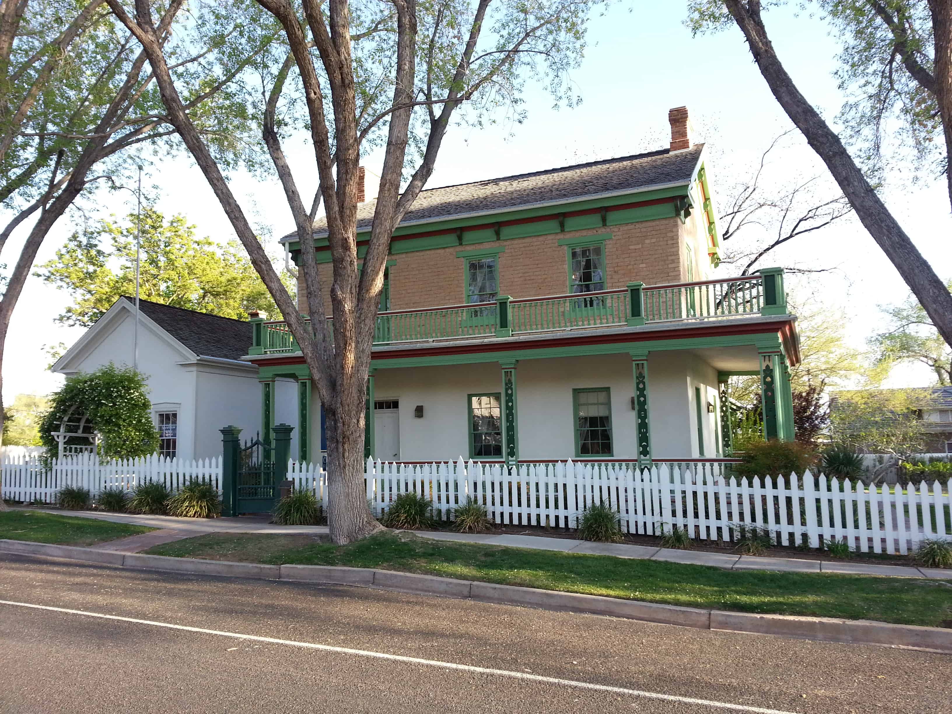
The Redmond Town Hall is one of the best remaining examples in Utah of a building which served as a community center for religious, educational and political purposes. The original adobe structure with the larger rock addition also stands as an excellent example of the evolution of community buildings in rural pioneer Utah.
Located at 18 West Main Street in Redmond, Utah and added to the National Historic Register (#76001836) on September 13, 1976.
The community of Redmond was settled in the late summer and early fall of 1875 primarily by Scandinavians from nearby Salina. The first years were devoted to the clearing of farm land and digging of irrigation ditches and canals. In 1881 the original adobe section of the town hall was constructed. Citizens contributed both money and work in the commercial undertaking. The 24′ x 36 adobe structure was used for LDS Church services, as a school, and for town meetings. Within a short time the building proved too small to meet the various community needs and in the mid 1890’s a larger two story rock building was constructed adjacent to the original adobe building,
The two connected buildings served as Redmond’s church and school until 1911 when a school house was completed west of the town hall and 1917. when a-church was built-across the street southeast of the building.
The town hall continued to function as a community center after 1917. It is presently (1976) being renovated as a community Bicentennial project.
The Redmond Town Hall consists of an adobe structure built in 1881 and an adjoining rock structure built in the 1890’s.
The adobe building measures 24 v by 36 feet, contains one room, is one story in height and has a gabled roof. Entry was made through either of two doors flanking a single window on the east side of the building. The multi-purpose room was heated by a stove connected to the chimney still situated at the north end of the building. The adobe walls have been sheathed with scored stucco intending to imitate smooth cut stone. An unpretentious edifice, the only decorative elements were the Federal lintel caps, the corbeled brickwork on the chimney and perhaps the modestly adorned box cornice and plain frieze. The ends of two beams supporting the ceiling joists can be seen resting in the wall from the outside of the building. Metal tension rods or tie bars are also apparent on either side of a large vertical masonry crack in the north wall. After its discontinuance as a meetinghall, the adobe building served as a jail. Steel bars in a few windows remain as evidence of newer function.
Connected to the small adobe on the south is the two-story rock Town Hall, built apparently between 1891 and 1897. While the earlier building was vernacular in style and unpresuming, the newer structure took on an air of dignity and style, however, modest. The rectangular structure was built of a light colored limestone quarried east of Redmond. The stone was cut, squared, slightly rock faced, and laid in a plain ashlar pattern.
Formality of design was provided by a regular window schedule with windows on both floors being of equal size and type and being arranged directly over one another. All window and door bays are segmentally arched with stone voussoirs of the same dressing as the face stone. All windows are 2/2 double-hung sash type and have wooden sills. The roof is hipped and has a lowered belfry on the ridge which runs east and west. The chimneys are brick and corbeled and are secured to the roof by metal tie bars. The cornice is simply boxed and overhangs the building by about 20″. There is no frieze or any decorative wooden or masonry trim.
As one enters the Redmond Town Hall through its only door, a large single room is found at the right (east) while directly ahead (north) is a stairway which leads to the two upper rooms on the second floor. The main room on the ground floor was used for mass meetings and as a small library. The council room was the smaller of the two upper rooms (on the east), while the other second story room (on the west) was used for recreational functions.
The interior walls, ceilings, floors, moldings, doors, hardware, etc., are almost completely intact. The door and window mouldings are a post-Eastlake type and provide the greatest element of architectural relief.
Both parts of the Redmond Town Hall are in stable condition and are undergoing restoration as a Utah Bicentennial project.
Brigham Young’s winter home and office was built for his convenience while spending the cold months in Utah’s Dixie. The great colonizer sent missionaries to the Virgin River area as early as 1856, Cotton production began the following year at Washington. In 1861, a major influx of colonists resulted in the establishment of St. George.
Young frequently visited the “Dixie Mission,” and spent his winters there between 1873 and 1877. One purpose was to encourage the settlers to finish the St. George Temple, which they did early in 1877. Brigham Young dedicated the temple before returning north in the spring. He died the following August.
Soon after his death, the family sold the home from the Brigham Young estate to Dr. Judd Gates, St. George’s first dentist. Dr. Gates used the upstairs for his offices. Later the home became rental property. By the early 1940’s it was vacant and needed repair.
The Young family again bought the property. Georgius Cannon Young, a grandson and architect of note, helped plan its restoration. The property was deeded to Utah State Parks and Recreation in 1959. The L.D.S. Church provided funds for re-shingling the roofs and the State Parks followed through with its restoration, which is well along, but not yet complete.
The Brigham Young Winter Home and Office is located at 67 West 200 North in St. George, Utah and the site was added to the National Historic Register (#71000863) on February 22, 1971.
The Iosepa Community developed after Polynesian converts to the Mormon faith were employed as laborers by the Iosepa Agriculture and Stock Company in 1889. After numerous hardships, including bouts with leprosy, the colony attained a degree of financial independence and its population reached 228. In 1915 when the L.D.S. Church began to build the Hawaiian Temple, the need for “gathering” subsided. The Iosepa project was allowed to end and most of the settlers and their children returned to the Islands by 1917.
Mormon Church Converts from Polynesia settled in Skull Valley in 1889-1917. Working for the Church-owned Iosepa Agriculture and Stock Company.
Their settlement located 1/2 mile to the southwest and named Iosepa (Joseph) after Joseph F. Smith, then President of the church flourished until 1917 when a Hawaiian Temple was constructed. Most of the Islanders returned to their homeland, many who succumbed to the hardships of the land are buried in this cemetery.
The Iosepa settlement in Skull Valley, Utah, represents both a unique colonization effort by the Mormon Church and in the West itself. Very early in the 1850’s the Mormon Church had sent missionaries to the Polynesian people. Joseph F. Smith served his first mission at the age of fifteen and became especially beloved to them. Later many answered the “call to gather to Zion,” and settled near Wasatch Springs in North Salt Lake City However, as they did not Integrate into the society very well, and rumors of leprosy were reported, the Mormon Church undertook to settle them as a group in Skull Valley. Under a paternalistic arrangement with the Iosepa Agriculture and Stock Company (incorporated August 7, 1889), these people were employed as laborers to do farm and ranch work. In time a community of 228 souls was developed in which the Polynesian culture flourished. Fish were raised in the springs and marshes nearby. The luau was preserved as were many of their dances and customs. The Polynesians were popular performers throughout the area.
After numerous hardships, including bouts with leprosy, the colony obtained a degree of financial independence by 1910. Their standard of living was commensurate with others living in that area. When in 1915, the L.D.S. Church began to build a temple in Hawaii, the need for “gathering” subsided. The Iosepa project was allowed to end. Most of the settlers and their children returned to the Islands by 1917. However, a few remained in the area of Iosepa and Utah. Today descendants visit the region to view “the land of their inheritance.”
The first funeral was held September 15, 1889 and the cemetery established. Many others have been buried there. Finally, in 1968 Tony Hoopiana, who had been born at Iosepa and lived nearby all his life, was buried in a northeast corner plot. This Hawaiian is home, forever.
The Iosepa Settlement Cemetery in Iosepa, Utah was added to the National Historic Register (#71000856) on August 12, 1971.
The area of Iosepa, in Skull Valley, Utah, was a large 1,920 acre ranch originally. With the settlement of the Hawaiians, a small community was established, following the “block grid” common to Mormon villages. A center block was reserved for the church, a schoolhouse and other public buildings, which were built in time. At first the water supply came from a stream and ran down the edges of the streets in ditches. Later a water system was piped through the town. One fire hydrant still remains. Most of the buildings have been removed or destroyed.
However, north of the town site sets the “Iosepa Cemetery,” a small plot enclosed with a black barbed wire fence, where several score of the colonists have been buried. Many of the graves are unmarked, others have only wooden markers, some carved, and a few stone markers reflecting their artistic qualities.
Although poorly cared for today, there is genuine interest in proper fencing and upkeep of the site from both the Bureau of Land Management personnel and the Deseret Livestock Company whose property line crosses the cemetery. Its location will permit the public to visit it, where an interpretive display can be developed.
The cemetery best preserves the story of this distinctive settlement experience by a Polynesian minority.
Built in 1901, St. Paul’s Episcopal Church was the first building constructed in Vernal by the Episcopal Church and the second to be built in the Uintah Basin; the first was the Indian Mission church at Randlett. Designed by John P. Hill, an architect from Salt Lake City, the building is a good example of the Gothic Revival style. St. Paul’s Lodge was constructed in 1909 as a home for girls who came to Vernal to work or attend school. It also served as the center of the auxiliary activities of the Episcopal Church in the community and, from the late 1920s until 1947, as the major hospital in the Uintah Basin. During the past forty years it has continued in use as the center of church and community activities.
Located at 226 West Main Street in Vernal, Utah and added to the National Historic Register (#85000049) on January 3, 1985.
St. Paul’s Episcopal Church, built in 1901, and St. Paul’s Lodge, built in 1909, are significant for their historical role as the center of the Episcopal church activities both in Vernal and in the entire Uintah Basin of northeastern Utah. Both buildings are also architecturally significant. St. Paul’s was the first building constructed by the Episcopal Church in Vernal, a predominantly Mormon town, and the second church con- structed by the Episcopal church in the Uintah Basin; the first was the Indian Mission church at Randlett, which has been moved from its original location in recent years. St. Paul’s is second only to the church at Randlett as the oldest church building of any denomination in the Uintah Basin. The building documents the spirit of expansion and missionary activity that characterized the Episcopal church in Utah at that time. Architecturally, it is significant as a good example of the Gothic Revival style. St. Paul’s Lodge, which was constructed as a home for girls who came to Vernal to work or attend school, is significant for its central role in the auxiliary activities of the Epsicopal Church in the community. The building also served as one of the early hospitals in the Uintah Basin and was the major hospital in the area between the late 1920s and 1947. It is architecturally significant as a good example of the Craftsman style.
The Reverend O. E. Ostenson arrived in Vernal on September 20, 1900 to begin the work which would lead to the building of St. Paul’s. Regular services began on September 30, 1900 in Jake Workman’s Opera House, but were moved on October 22 to the Odd Fellows Lodge room. The first church committee was appointed by the missionary, Reverend Ostenson, on April 23, 1901.
Property was purchased by the Corporation of the Episcopal Church in Utah for $325 on the H7th of February, 1901 for construction of the church in Vernal. On May 16 of the same year, plans for the building had been completed by Salt Lake architect John P. Hill. Very little is known about Hill or his career in Utah. The church committee let the brick and stone work contract to Andrew Burkley and the carpentry work to William Cook on July 18, 1901. Ground was broken for the church on July 26. Three weeks later on August 20 the Rev. Ostenson, assisted by Indian missionary M.J. Hersey of Randlett, laid the cornerstone for the new church. With the permission of the rector, Miss Anna Forrest named the church that same day. It was named St. Paul’s after St. Paul’s Church in Washington, D.C.
Another building on the site is the parish house. Built in 1909, it was originally called St. Paul’s Lodge and was built by the Girl’s Friendly Society of New York as a home for girls who came to Vernal to attend school or to work. It also served as a center for civic activities and club meetings. In 1928, St. Paul’s church was closed because of inactivity. Four years later the lodge was sold and served for the next several years as the major hospital in Uintah County. Dr. Parley G. Eskelson ran the hospital, and even built his own house next door so that he would always be nearby. At the time that the building was converted into a hospital, its interior was renovated and remodeled in order to meet the needs of a medical care facility. The building had previously been used temporarily as a hospital during the flu epidemic of 1918, and was reportedly used again for a short time in the late 1920s under the direction of Mrs. Jane Murray.
St. Paul’s was reactivated in January of 1947 when Rev. Walter F. Cable was sent to be Deacon-in-charge by the Bishop of Utah. Two years later the lodge was repurchased by the church and has since served as the parish house with apartments for the vicar and meeting rooms for the church. The church building itself has continually remained in the hands of the Episcopal Church.
St. Paul’s Church is the second oldest religious structure still standing in the Uintah Basin. An Indian mission church of the Episcopal Church was built in Randlett in 1896, but it has been moved from its original location. St. Paul’s was completed prior to any of the existing religious buildings in the Vernal area – including LDS structures. The relatively late construction dates of church buildings in Vernal can be attributed to the fact that permanent settlers were not established in Vernal until after 1870.
St. Paul’s Episcopal Church is a small town parish church designed in the Gothic Revival style. It is a rectangular building and has a steeply pitched gable roof, brick exterior walls, and sandstone sills, foundation, and water tables. A large, pointed arch window is centered in the gable end wall facing the street, and it features ornate stained glass and wooden tracery elements. Two brick buttresses flank the stained glass window. The buttresses are decorative and are not repeated on the rear of the building, which has wood shingle siding instead of brick exterior walls. There are five buttresses along each side of the building which appear to be structurally supporting the roof trusses that are exposed on the interior. Pointed-arch, stained glass windows are evenly spaced on the sides of the building between the buttresses.
Alterations to the building are minor and do not detract significantly from the original integrity of the building. A small, concrete block addition was built on the rear of the church (n.d.), but it is not visible from the front or public views. The original wood shingles on the roof were replaced by asphalt shingles a number of years ago. On the interior, carpet has been added in the center aisle and in the altar area, and an entry cubical has also been added (n.d.). In recent years, in order to protect the stained glass windows on the building, sheets of transparent, hard plastic have been fitted into the window openings on the outside of the stained glass.
St. Paul’s is an excellent example of a small Gothic Revival church building. Elements which distinguish the church as a Gothic Revival building are the steeply pitched gable roof, the buttresses, and the pointed arch stained glass window with tracery and colored glass. It is probably the best example of the Greek Revival style in both the city of Vernal and the Uintah Basin.
St. Paul’s Lodge is a two-story, brick Craftsman style house with a gable roof and a full-width, one-story front porch. Elements of the Craftsman style include the broad gable roof, the half timbering in the upper portion of the gable end, and the exposed rafters and purlins, and the exposed woodwork in the gables of the wall dormers and porch on the west side of the building. The four symmetrically spaced windows on the upper story of the façade have pointed relieving arches. There is a bay window on the west side of the building. The foundation is constructed of coursed sandstone. There is a one-story gabled section on the rear of the building, which, judging from its appearance and materials, was probably built at the same time as the main portion of the house.
Alterations that have been made on the exterior of the house are minor and do not significantly detract from its original appearance. The exterior brick walls have been painted (n.d.), and the openings on the front porch have been filled in with windows (n.d.). The interior of the house was altered somewhat when the building was converted into a hospital.
Houses designed in the Craftsman style in Utah are quite limited, based on the results of the partially completed state survey of historical and architectural sites. The Craftsman influence, however, was profound, especially in the first two decades of the twentieth century. Broad gable roofs, exposed rafters and half timbering are the most prevalent evidence of the Craftsman influence and occur on bungalows in most Utah towns. Even though St. Paul’s Lodge is not a premier example of the style in the state, it is significant as one of the few houses that were specifically designed in the Craftsman style.
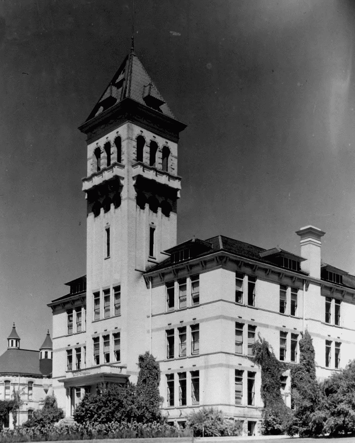
The Agricultural College of Utah was established by act of the 1888 Territorial Assembly. On March 26, 1889, the Board of Trustees met in Logan, accepted the offer of the campus site, and instructed the secretary of the Board “to advertise ‘for plans for a $20,000 building, plans to be delivered to the secretary before the 15th of April. On April 15, the Board met in Logan, accepting the plan of C. L. Thompson for a three-section structure. On May 18, 1889, the Board awarded the construction contract for the south wing to Sommer, Peterson and Company of Logan for a total cost of $20,305. The south wing was completed and accepted by the trustees on February 22, 1890. The College was dedicated on September 4th and officially opened on September 5, 1890, with the south wing of Old Main as the only complete classroom facility. As it stands today, Old Main is the oldest continuously used building at an institution of higher education in the State of Utah. During its history, it has housed virtually every University department or office. It is the best example of the “Campus Gothic” of the last century.
Located on the Utah State University campus in Logan, Utah and added to the National Historic Register (#72001258) on February 23, 1972.
The original plan by C. L. Thompson was for a three-section buff colored brick and stone structure 270′ x 100′ with sections that could be readily erected independently of each other. The south wing was completed February 1890. In 1892 the Board authorized the construction of the north wing and the east portion of the central section. The original plans of C. L. Thompson were re-drawn by Carl S, Schaub, a Logan architect. The new plans called for a building of 342′ x 190′. The Thompson plans for the north and south wings were maintained, though Schaub modified the projected tower and greatly enlarged the central section of the building, which until then had been planned as little more than a glorified hall between the two wings, A completion date of 1894 was postponed by the panic of 1893. Finally in 1901 and 1902 the front 80′ including the tower, was added to the structure.
In 1892 the catalog described the structure’s many uses:
“It contains . . . recitation rooms . . . workshops, cooking, sewing, householding, dairying, laundering, engineering, agricultural and business departments . . . laboratory, museum, library and gymnasium rooms and a military drill hall of ample size. Its audience room or chapel will hold 1600. Three large rooms have been set aside for halls for the literary societies. Its rooms are light and pleasant to a rare degree and its halls wide and roomy, extending on each floor the entire length of the building. In the near future, large bath rooms will be put in for the accommodation of both sexes, where baths can be taken at pleasure.”
Though the interior has been remodeled and some incongruous modernization done, Old Main retains enough of its original style to stand as the principal Utah example of the “Campus Gothic” of the late 19th century.
Fort Cameron is important because of its relationship to three significant aspects of Utah history.
In the early 1870’s, Indian raids against the isolated southern Utah communities began to occur with enough regularity and intensity that local settlers were fearful of the kind of confrontation that had characterized the Black Hawk Indian War in that area during the mid 1860’s.
In a letter to Washington officials, Cyrus M. Hawley, associate justice of the Utah Supreme Court, noted that attempts to bring those individuals guilty for the Mountain Meadows Massacre to trial were unsuccessful and would continue to be so until witnesses were convinced that the Federal Government would guarantee them protection, Hawley went on to recommend that a military force of at least five companies be sent to leaver to render the required protection.
Because of the “Indian problem” and the “Mormon problem,’ Secretary of War William W. Belknap recommended a governmental appropriation of $120,000 to construct a military post near Beaver. After the money was appropriated, Colonel John D. Wilkins, with four companies of troops (about 181), was sent to establish the post in mid-1872. After President Ulysses S. Grant officially set aside the reservation on May 12, 1873, the fort was named Fort Cameron in honor of Colonel James Cameron who lost his life during the Battle of Bull Run.
After the completion of the Utah Southern Railroad to Milford in 1880, General Phil Sheridan recommended that the post be closed because troops could be transported by rail into Southern Utah. Accordingly, the fort was closed May 1, 1883 and the troops removed to Fort Douglas.
The land and buildings were purchased for $15,000 by John R. Murdock, President of the Beaver Stake of the Church of Jesus of Latter-day Saints and Philo T. Farnsworth, former bishop of the Beaver Ward. Apparently the purchase was made in behalf of the church for, in 1893, Fort Cameron was converted into an academy. The laundress quarters were used as a dormitory to house students coming from outlying areas. In 1922, the church decided to discontinue the academy. The land was sold and the school equipment donated to Beaver High School.
The last use of the laundress quarters was made in 1937-1938 when a branch of the Milford Civil Conservation Corps was housed there.
The original fort site was laid out in a rectangular shape 700′ x 620′. In the center was a parade ground around which the buildings were constructed. On the east side and on the west side stood two barracks. On the south side were six officers’ quarters. To the north were the hospital, the headquarters building, and commissary store, Next to the east barracks stood the bakery. The stables were 300 yards west of the post.
The buildings were constructed of the black, basaltic lava stone quarried nearby, mainly by local laborers. The original buildings were roughly plastered except for a two-story, 12-bed hospital which was finished with plaster of Paris.
When taken over by the LDS Church for an academy, the buildings were remodeled and a new building constructed. However, after the buildings were abandoned as a school in 1922, they soon fell into disrepair. In 1938, the CCC and WPA programs cleared away debris and built a race track.
Today only one building, the laundress’ quarters, remains. It was of black basalt rock, but altered slightly. Its rectangular dimensions are 31′ x 57′ with a gabled roof. The building has three chimneys, both ends and the center, and divides lengthwise with four rooms on each side, an outside door and a window for each room. Some of the interior partitions have been removed.
With the plans of the fort still available and part of the site undisturbed, there is good archaeological potential for much of the site. However, part of the fort site has been covered by the Beaver Golf Course. Primary preservation efforts will be devoted to the restoration of the launderess’ quarters building.
The fort was added to the National Historic Register (#74001932) on September 9, 1974.
The Hans Peter Olsen home was constructed in 1877, nineteen years after Mr. Olsen came to Utah from Denmark. Born May 30, 1833, in Jutland, Denmark, Hans Peter Olsen grew up on his father’s farm, In 1853 he joined the Mormon Church and spent the next four years as a traveling elder in his native country, In 1858 he sailed from Denmark on board the John Bright. Although the Utah War forced most of the European emigrants remain at Iowa City and Florence, Nebraska, until the following year, a group of fourteen “Danish Fellows” of which Hans Peter was a member, was allowed to journey to Utah with a group of missionaries returning to Utah in the Eldredge company. In November 1858 he settled in Manti and the following spring moved to Moroni as one of the first settlers of that community. In 1867 he moved to Fountain Green and ten years later constructed the lovely brick home. He returned to Denmark on two missions for the LDS Church first in 1869 and again in 1891, While living in Fountain Green, he was a farmer and director of the local co-op store.
The significance of the Hans Peter Olsen home is that it is one of the finest pioneer brick homes in Sanpete Valley.
Located at 211 South State Street in Fountain Green, Utah and added to the National Historic Register (#76001834) on April 22, 1976.
The Hans Peter Olsen home is significant architecturally as an outstanding example of pioneer industry, design and craftsmanship. The well preserved residence embodies the best elements of representative pioneer building during the transitional period of vernacular to “high-style” architecture. Late pioneer features such as the symmetrical 3-bay front façade, four-over-four plan, end wall chimneys and Federal entry bay are combined with less typical decorative embellishments such as Roman-arched upper windows and an unusual corbeled brick cornice with dentil band where a wooden frieze would ordinarily appear. In an area of predominantly white limestone homes, the Olsen home stands out as being unique to the region. Craftsmanship throughout the structure is excellent, a fit compliment to the stateliness and utility of the design. Qualities of permanence and beauty in the building reflect Olsen’s philosophic commitment to Mormon concepts of Kingdom-building in the Sanpete County community of Fountain Green.
The American Fork Historic District is locally significant, both architecturally and historically, because it represents the social, economic and architectural history of American Fork, Utah. The district is significant under Criterion C for its concentration of intact examples of residential buildings built during the major construction periods in the town’s history, from 1868-1940. The district accurately represents the wide range of architectural styles, types, and construction materials found in American Fork. The district is also locally significant under Criterion A as a reflection of American Fork’s residential settlement patterns and community growth through 1940. Founded by members of the Church of Jesus Christ of Latter-day Saints (LDS, or Mormon church) in 1850, American Fork experienced steady growth as an agricultural community, and later as a commercial center for northern Utah County through the arrival of the railroad in American Fork in 1873. This growth has continued into the twentieth century and up to the present.
Mormon Settlement 1850-1867
The site of American Fork was first considered as having potential for settlement by two early pioneers, Arza Adams and Stephen Chipman, who camped in the vicinity while traveling to Provo in the summer of 1850. Favorably impressed, Adams and Chipman asked permission from Brigham Young to establish a cattle ranch in the area, but instead were instructed to undertake a survey. Two sections of land were laid out in what was known as the “Big Survey,” encompassing the early townsite and the riparian area along American Fork Creek. The town of Lehi, a few miles northwest, had recently been surveyed, and this was used as the baseline.
Three aspects of the community’s inception differ from that associated with traditional Mormon settlement, two of which are noted by Lowry Nelson in The Mormon Village. First, the intention of Adams and Chipman to establish a large ranch was a departure from the usual pattern of Mormon settlement in which land was subdivided into small tracts. Second, many families constructed a house and lived on their farms, rather than reside in the village and travel to their land. Finally, settlers first lived on along the creek, where they had proximity to water, rather than in the orderly lots laid out in even blocks that characterized Mormon villages.
The threat of unrest between the settlers and the Indians in 1853 ended any dissimilar patterns. Residents were instructed to construct a fort and move within its walls. The pioneers’ log homes were moved within the fort but as the Indian danger dissipated, enthusiasm to complete the fort faded and it was never completed. From 1853 on, settlement was less dispersed and the plan of the village followed that of the fort.
During the 1850s and 1860s life in American Fork centered on survival. Farming and raising livestock was the basis of the economy. Small businesses and stores, such as the glass and crockery store established by Richard Steele in 1851 existed, but the exchange of goods transpired through trade and little cash was used. These decades were spent in building the community’s economic and physical infrastructure, and establishing the institutions that the settlers had known elsewhere. George Shelley describes the early accomplishments:
Among these were the gathering of the people together from their various locations along the creek into a compact community surrounded by a wall, the assuming of the distribution of the irrigation water… the allotment of land to the settlers, the making of roads and bridges…
The subsistence standard of living, the lack of materials and sophisticated tools and the isolation from national markets affected the community’s architecture. The first homes were constructed of logs, (some of hewn-log construction), chinked with chips and covered with mud mortar.
The next phase of construction was characterized by the use of adobe bricks. Residents found a good quality of clay in the wetlands southwest of the community and constructed an adobe mill. Adobe provided a more comfortable dwelling and allowed for stylistic forms and embellishments. In 1860 a new meetinghouse was built out of adobe with a granite foundation; later photographs indicate that the building had the moderately-pitched gable roof and cornice returns associated with the Greek Revival style in Utah. This building also served as a school.
Stability and Growth, Construction of Railroad through American Fork, 1868-1880
By the late 1860s life in American Fork was stable enough for residents to strengthen municipal institutions, support mercantile trading, and create more substantial and style-conscious structures. In 1867 the Deseret Telegraph Company opened an office in American Fork, providing access to communication on a national scale. Also in this year territorial legislation was passed giving local governments the right to maintain free public schools through taxation; this bill was sponsored by Leonard Harrington, American Fork’s first mayor, LDS bishop and Utah County legislative representative. After the bill passed, American Fork residents voted in favor of this option and became the first community in the territory to fund public education. A road and a narrow gauge railroad were constructed in the 1870s in American Fork Canyon to service mining activity. This, along with the construction of a mill with a circular saw at the mouth of the canyon, provided a much greater supply of lumber. Mining also brought in an influx of cash and helped the growing mercantile base in the town. Most significantly, the Utah Southern Railroad Company opened transportation through American Fork in 1873.
These developments affected the architecture and the physical appearance of the town. Residential architecture began to reflect national trends. Although the Greek Revival style, which had died out nationally by 1840, remained popular in American Fork and throughout Utah through the 1880s, the Victorian Eclectic style was used in American Fork by 1875. The William-Abner Chipman House at 269 S 100 W (c.1875) is a prime example of the Victorian influence. Homes in this style exhibited cross-wing, side-passage and central block plans. Adobe continued to be used but fired brick became the predominant material. An example of adobe house remaining in American Fork is the Greek Revival George & Mary Spratley House (c.1875) at 29 E 100 South. These trends are reflected in the surviving buildings of the district.
Two new schoolhouses, serving the neighborhoods east and west of the creek, were constructed. The 1860 adobe church was expanded in 1877 by a 30 x 50 foot addition and was thereafter known as “the Science Hall.” Bate Hall, a community recreation center, was built out of rock in 1876. A Gothic Revival Presbyterian Church was constructed the next year.
Once American Fork had rail access, its history and architecture were very much in keeping with the rest of Utah and the nation. Its location, between Provo and Salt Lake City, meant that it had a steady stream of travelers and access to outside markets and culture. The community continued to mature during the 1880s and through the first decade of the twentieth century. In 1883 rail service expanded with the extension of a Denver and Rio Grande Railroad line through American Fork. In the early 1890s municipal services improved: new streets were opened, a new survey was undertaken, city government became more structured and uniform city ordinances were established. Electric street lights were installed in 1901, the houses were numbered in 1905, and a fire station was constructed on Main Street in 1913. In 1899 the American Fork Co-op built “a commodious brick store” on Main Street, contributing to the town’s prosperous appearance. The Co-op was established in 1873 as part of Brigham Young’s efforts to keep mercantile business in Mormon hands. Closing in 1930, it had outlasted other co-ops in the state. In 1892 the Chipman Mercantile company was founded and became the largest retail operation in Utah County. The opening of the sugar beet factory in Lehi in the 1890s augmented the agricultural base in the county. This commercial growth in American Fork is reflected in the homes of the district. There are many large homes from this period still extant on Main Street including the Victorian Eclectic J. Chipman, Jr. House (c.1893, 121 W Main), the Greek Revival Emeline Sykes House (c.1905, 184 W Main), and the Queen Anne Vance/Walton House (c.1902, 195 W Main). Many homes built in the district were by families newly prospering from the City’s commercial growth. Often these owners were members of established American Fork agricultural families branching out into new commercial and industrial interests.
In 1901 a general reorganization of the LDS Church in Utah County took place. The original Utah Stake of Zion, (the LDS “stake” is equivalent to a diocese) which once encompassed Mormon wards (equivalent to parishes) in all of Utah County, was divided into three Stakes. American Fork became part of the new Alpine Stake. The single ward in American Fork was divided into four congregations, necessitating four new chapels. All four, two of which were in the district, were of built of brick in a Gothic Revival style. The Alpine Stake Tabernacle, found within the district boundaries at 110 E. Main St., is another significant LDS structure of this time. It reflects a new era of church building in a variety of revival and modern styles.
In 1914 Jesse M. Walker began raising white Leghorn hens for egg production on a commercial scale, marking the beginning of a prosperous poultry industry for American Fork. This seems to have had a great effect on the town, both economically and physically, as it was an enterprise that many people could participate in because it did not involve a large capital investment. The large lots of 1.25 acres (eight to a block) were conducive to the growth of this industry; Lowry Nelson writes that the space provided in this area was often sufficient for a poultry business large enough to supply a family’s livelihoods. This resulted in an expanded agrarian overlay to a community in which keeping livestock on property within the city was not unusual. Even today many henhouses and outbuildings associated with the poultry business are extant.
Progressive-Era Ideals and Economic Depression, 1900-1940
Beginning about 1910, domestic architecture moved away from the prevailing Victorian Eclectic style and bungalows became popular. The 1987 architectural survey indicates that this house type was used as early as 1901 but had become very popular in the next decade. Bungalows in American Fork are generally simple brick structures with a rectangular form and a hipped roof; more elaborate examples have Prairie School and Arts and Crafts elements. A few larger, Prairie style foursquare plan houses were also constructed in American Fork during this time, including the Chipman/Firmage House at 6 S. 100 West, and the Chipman/Robinson House at 208 W Main Street. Frame Craftsman bungalows, with brackets, clipped gables, and clapboard siding, offered an alternative for a small, modest house. Period Revival cottages of English Tudor styling were built beginning in the teens and through the 1930s and 1940s.
American Fork continued to benefit from the progressive ideals characteristic of the turn of the century. The city purchased land for a city park in 1920 and received a grant from the Carnegie Foundation and constructed a library designed by Ware and Treganza in 1923. School consolidation occurred in 1915. In 1929 state legislation was passed establishing several institutions assisting the mentally and physically disabled; American Fork was chosen as the site for the State Training School for mentally retarded citizens. By 1945 the school had 659 students and 86 full-time employees — a boost for the local economy.
During the 1930s American Fork experienced the hardships of the Depression but received some relief through the Works Progress Administration. WPA projects within the district included the improvement of City Central Park and graveling and hard-surfacing the streets. Outside the district boundaries, an amphitheater and wall at the State Training School, a stone wall around the cemetery, and an addition to the Harrington School designed by Provo architect Joseph Nelson of Nelson and Ashworth were all WPA projects that had a lasting influence on the physical fabric of the city.
Recent Development and Influences, 1940 – present
In the early 1940s the Geneva Steel plant was constructed to meet the demands of World War II. Several large subdivisions, including Columbia Village, Thornwood and Richland Park, were constructed to meet the related housing demand. Although located outside the district boundaries, these subdivisions had a lasting impact on the physical surroundings comprising the setting of the district area, and diminished the surrounding farmland that many residents of the district once owned as farmland. Architecturally these subdivisions represent one of the state’s “Levittowns,” in the sense that the homes were almost identical and small with compact floor plans. Their design lent them well to cost-effective and speedy construction. These subdivisions, along with those more recently constructed, have disrupted the pre-1940s layout and appearance of American Fork.
Probably the most significant post-World War II change to the physical character of this community was the construction of an interstate highway along the western edge of the city during the early 1960s. The resulting bypass of traffic has negatively affected Main Street businesses, as have the more recent construction of regional shopping malls. American Fork is no different from all communities along the Wasatch Front, in that maintaining a distinct identity, rather than acting as a bedroom community for Provo, Orem and Salt Lake, has become difficult.
The American Fork Historic District is an important historical resource because it represents the settlement and development of American Fork, Utah. The district is locally significant as a physical reflection of the residential architectural and historical development. The houses and outbuildings within the district provide a complete representation of the wide range of architectural styles and plans popular in the city between 1870 and 1940.
The district excludes the downtown commercial district including a city hall, a school, the old dance hall and more because of their lack of integrity.
Narrative Description
American Fork is located in Utah Valley near the north end of Utah Lake, fifteen miles north of Provo, the Utah County seat, and thirty miles south of the State Capital, Salt Lake City. The city contains a central historic commercial and residential core area, which is surrounded by suburban subdivisions built on what was once agricultural land.
The American Fork Historic District is located in the historic core of the city and is built upon a grid of five acre blocks separated by wide streets. Following the original Plat of Zion as envisioned by Mormon church founder Joseph Smith, each block was originally divided into eight lots, though every block within the district has since been subdivided and open space filled with new construction. All of the streets are paved and are lined with curb and gutter and sidewalks. Large, mature trees line the streets and shade residential lots throughout the district.
Residential Buildings: The district is irregularly shaped, and includes only portions of twelve downtown blocks, wrapping around the commercial area that no longer retains its integrity. The primary east-west axis of the district runs along 100 South, while the north-south axes are 200 West, 100 West, Center St., and 100 East. The district is almost exclusively residential in character, and contains a variety of houses from four general building phases: 1868-1880, 1880-1910,1910-1940, and 1940-present. Although out-of-period and altered structures are found throughout the downtown area, the district retains its overall integrity of feeling and association.
No properties dating from the earliest period of American Fork’s settlement (1849-1868) are contained within the district. The earliest properties in the district date from the late 1870s, around the last years of American Fork’s pioneer settlement, before the arrival of the railroad. The remaining examples from this time are single-story, symmetrical hall-parlor or crosswing type, gable-roofed houses, in simple vernacular classical styles. Decorative details, when present, are inspired by the Greek Revival. These houses are generally constructed of adobe or soft fired brick and are most often covered with stucco.
The bulk of the district’s buildings (approximately 67) date from the period 1880-1910. These are primarily Victorian Eclectic and late Greek Revival crosswing or central-block-with-projecting-bays houses, usually one or one-and-a-half stories in height. Fired red and putty colored brick is the most common building material of buildings of this time, though wood frame houses are also found. The Victorian houses are characterized by asymmetrical façades, prominent front gables, and substantial one-story porches with Classically inspired turned columns. Foundations are most often coarsely laid sandstone, though concrete came into use toward the end of this period. Roofs are a mix of gabled and hipped types. Windows on the front elevations consist of large single panes with fixed transoms, or one-over-one double-hung sash types.
Houses of the period 1910-1940 fall into two distinct types: the bungalow and the period cottage. The bungalow appears frequently in the district; approximately twenty-eight houses in the district are bungalows, or variations thereof. Two variants of the bungalow style, most examples of which were built in the first half of this period, were commonly found in the district: the more popular dark reddish brown brick version with a low-pitched hipped roof and broad front porch embellished with battered concrete columns; and the more modest frame, side gabled dwelling with clipped, or jerkinhead, gables. Both are distinguished by simple, rectangular footprints and wide, low slung eaves. Often both types were adorned with arts and crafts details such as roof brackets and exposed rafters and purlins. A few examples of the Prairie School style of bungalow can also be found in the district. Stylistic features include the wide overhanging eaves, a low hipped roof, horizontal banding, and geometric ornamentation.
Approximately 18 Period Cottage houses built during this period are located in the district. This house type encompasses several different period revival styles. By far the most frequently occurring style of period cottage in the district is the brick Tudor Revival cottage, in which a relatively simple rectangular cottage is elaborated upon by a steeply pitched entrance gable intersecting the side-gabled roofline.
Approximately 29 out-of-period buildings comprise the rest of the properties in the district. These consist of post-WWII cottages and modern ranch houses. Although such out-of-period buildings are found throughout the district, they are compatible in scale and materials with the historic buildings and do not detract overall from the character of the district.
Outbuildings: Several historic outbuildings are found scattered throughout the district. These are largely wood frame granaries and sheds and wood frame and brick automobile garages. Many out-of-period outbuildings are also present. Like the out-of-period houses, these outbuildings are compatible in scale and materials with the historic buildings and outbuildings and do not detract overall from the character of the district.
The Municipal Building was constructed 1938-1939. The construction was funded with $85,000 provided by the city and a $90,000 federal grant from the Works Progress Association. The building is significant as one of the largest buildings constructed in Utah under the WPA Program and for the mural depicting the history of early Carbon County painted on the four walls of the foyer as part of the Federal Arts Project of the WPA by the Price-born artist, Lynn Fausett.
The Price Municipal Building is located at 185 East Main Street in Price, Utah and was added to the National Register of Historic Places (#78002652) on February 17, 1978.
From the National Register’s nomination form:
The Price Municipal Building is a two-story flat-roofed structure of irregular shape (roughly rectangular) constructed of concrete and light-colored brick. The building houses offices for Price City, which are located on both the first and second floors, an auditorium, handball court and gymnasium, which has been converted into a museum. Located in the northeast corner of the building is a garage which originally served as a fire station. Constructed with the use of WPA funds during the late 1930s, the building is architecturally similar to other municipal buildings constructed during this time period. There are two main entrances to the building, one on the north along Main Street which enters the main office area and the second on the west side of 200 East, which enters the foyer and provides access to the theater and gymnasium. The foyer is the location of the Lynn Fausett mural depicting the history of the area.
The Price Mural
Following an absence from Utah of sixteen years, Lynn Fausett returned to his home town of Price in 1938. Discouraged by his recent divorce and the bleak prospects for success as an artist in his native state, the Price mural was a turning point in his career. The mural depicts events and themes significant in the history of Carbon County. The mural is painted on all four sides of the building’s foyer. The four foot high mural occupied some 200 feet of wall space. Regarding the mural Donald Hague writes: , “The principal figures within the mural are approximately one half size. There are some 82 figures throughout the painting discounting the many smaller figures which appear in deep perspective in the background. The artist worked from photographs, tintypes, and personal recollection in recreating the characters portrayed. The mural, in affect, offered Lynn the opportunity to totally submerge himself in a subject with which he had deep personal ties. It allowed him, he said, to maintain his sanity during the stress of divorce, and separation from his children, and in another sense permitted him to relive his childhood through the mural.”
James L. Hazeltin, in his book One Hundred Years of Utah Painting, observes, “It is surprising to learn that after seeing reproductions of the Price mural, it is only 4 feet: high, for it is difficult to obtain monumentality in a narrow strip encompassing a low-ceilinged room. Fausett has done it, and maintained the two-dimensionality of the wall, with an unusual blend of Rubenesque form and Piero della Francescan mood and color.”
The first scene of the mural, located on the west wall, depicts Abram Powell and Caleb Rhodes who entered the area as trappers in 1877. The cabin constructed by Abram Powell on the Price River in 1877 is shown as well as the dugout built by Caleb Rhodes in the area of present-day Carbonville. The two men remained on the Price River until early 1878 when they returned to their homes in Salem. In December of 1878 Abram Powell was killed by a bear on Mt. Nebo and his brother, John Powell, took up the Abram Powell homestead in 1879. The return of Caleb Rhodes and John Powell with their families in 1879 marked the beginning of a permanent settlement in the area. This event is depicted by a newly constructed dugout with an adjacent covered wagon and man plowing in the background.
The second scene depicts the construction of the Denver and Rio Grande Western Railroad through the area in 1882-1883. The painting shows both Chinese and European workers laying rails with the familiar cliffs and mountains in the background. The completion of the railroad between Salt Lake City and Denver was not only of importance to the entire state, as it served to end the monopoly of the transportation system by the Union Pacific Railroad, but of great local importance as it brought in a large number of new settlers, men to freight from the Price depot to the more isolated parts of eastern and southeastern Utah, and miners to dig for coal in the newly opened mines at Castle Gate and Sunnyside.
The third scene shows the store and post office built by Fred Grames in 1883. Grames is shown with W. H. Branch surveying the Price Canal in 1884. Their instrument was a level tripod with two lamp chimneys filled with water. Sighting through the lamps the two men laid out and surveyed a course which is still followed by the canal. To the right of the two men is shown the original log meetinghouse. Constructed in 1884, it served as church, town hall, and school.
The fourth scene is of a group of freighters at their campgrounds located near the railyards. After completion of the Denver and Rio Grande Western Railroad in 1883 Price became the rail head for shipping goods into the vast area to the north and east known as the Unita Basin. Freighters carried supplies to the Uintah-Ouray Indian Reservation and Fort Duchesne. After the discovery of gilsonite the wagons hauled gilsonite from the Uinta Basin to Price where it was shipped by rail. Men included in the scene are A. J. Lee, manager of the Gilsonite Company; Chuck Fausett, a freighter and uncle of the artist Lynn Fausett; Bert McMullin, a freighter and another uncle of Lynn Fausett; Matt Warner, a former companion of Butch Cassidy and later marshall of Price; Henry Kelsey, another freighter; Sam Gilson, the developer of the gilsonite industry is shown in his familiar Prince Albert coat; Oz Barlow, another freighter is also pictured.
The fifth scene, located on the north wall, is a view of the Price East Main Street in 1892. The dominent building in the scene is the Price Trading Company store where both of the artist’s parents worked. Lynn Fausett’s mother, Josephine Bryner Fausett, is pictured in the doorway of the store wearing a white apron.
The sixth scene is a group of seven people, A. W. Horsley, C. H. Taylor, A. Bollinger, an unidentified woman with a child, E. S. Horsley, and Isabell Birch Bryner. In the scene Mrs. Bryner is holding a petition to incorporate the town of Price. According to the account, by 1892 all the men had used up their homestead rights for farms and Mrs. Bryner, a widow, was asked by the local people to use her homestead right to file on the property which had been chosen for a townsite. Threatened by reports that someone else was headed to Salt Lake City to file on the proposed townsite, Mrs. Bryner was rushed to Salt Lake City by train to file on the land. She was successful in obtaining the land which was then sold into lots.
The seventh scene, located on the east wall, is a portrait of J. M. Whitmore, a prominent early rancher and first president of the town board. In the background is the first town hall.
The eighth scene depicts the religious history of the community. The three leaders of the dominant non-Mormon religions, the Catholic Bishop Lawrence Scanlan, the Greek Orthodox Priest Reverend Mark Petrakis and the Methodist Minister Reverend R. P. Nichols, are shown in a group portrait. To the right are illustrations of the Notre Dame de Lourdes Catholic Church in Price, constructed between 1918 and 1923; the Price Academy Building, a school operated by Reverend Nichols; and, the Greek Orthodox Church of the Assumption, completed in 1916. The Mormon story is portrayed in a scene showing the organization of the Mormons in 1882 by Bishop George Frandsen. The figures in the scene are Mrs. George Robb (with baby), George Robb behind his wife, Grandmother Mud in a bonnet, Mr. and Mrs. Henry Empey sitting next to the table, E. W. Mclntire, first counselor to Bishop George Frandsen is sitting behind the table, Soren Olsen, the ward clerk, is sitting at the table. The rest are unidentified.
The ninth scene illustrates the theme of law. Justice of the Peace Erastus W. Mclntire is shown conducting the community’s first marriage between Gilbert Peterson and his bride Ann. Mrs. Mclntire is present and the best man and Mclntire’s son are shown holding the pigs which were brought as payment for the marriage fees. In the background is the old Carbon County Courthouse with its statue of Justice atop the building.
The tenth scene concerns the theme of education. Two of the town’s early school buildings are shown and a group portrait includes Sally Ann Olsen, the first school teacher, collecting children in her buckboard; W. J. Tidwell, who surveyed the Price townsite and became the first public school teacher; L. M. Olsen, the first superintendent of schools; and Joseph Birch who sponsored in the Utah Legislature a bill providing for free public education. Another setting shows Carl R. Marcusen, principal of the Price Public School and later president of the Board of Education. Behind Marcusen is the old Carbon High School with the still familiar “Block C” located on the cliffs behind the school.
The eleventh scene shows Lynn Fausett as a small boy leading his blind grandfather Haws Ulrich Bryner.
The twelth scene, located on the south wall, shows W. Grant Olsen, first mayor of Price in 1911. A community promoter, Olsen is shown planting trees in the new Price City Park. In the background is a statue of a pioneer woman executed by Dean Fausett, brother of Lynn Fausett.
The thirteenth scene depicts a Fourth of July parade in 1911. Shown are two horse-drawn floats and the marching band.
The fourteenth scene commemorates the importance of the coal industry to the county. The first setting shows two men working at the Sunnyside coke ovens in 1917. Coke from the Carbon County area was of prime importance to the smelting industry of Utah. The next setting shows three miners emerging from a mine tunnel. Both the American-born and southern European miners are represented in the picture. The third setting shows the outside workings at Sunnyside in 1917. World War I brought a tremendous expansion of the Carbon County coal industry and the setting depicts the activity which characterized the coal industry during this period.
Statement of Significance
The Price Municipal Building is of significance primarily because of the mural depicting the area’s history which was painted as a Utah WPA arts project by the noted Utah artist Lynn Fausett. The mural represents the best work of art produced during the WPA art project in Utah and is of great value as a historical document in portraying the themes and personalities of the area’s early history. The building itself was one of the largest WPA buildings constructed in Utah. Architecturally the building is a good representative of the international design for public buildings during the last half of the 1930s.
History
On June 8, 1936, the Price City Council authorized an application to the Works Progress Association for a loan and grant to aid in financing the construction of a municipal building. Lewis T. Cannon and John Fetzer were architects for the building, and under their advice Price City requested a $67,500 grant from the WPA which would cover forty-five percent of the estimated $150,000 project. Under WPA requirements projects would have to be supported by a fifty-five percent local expenditure.
In order to receive the grant Price officials would have to provide a local match of $82,500.00. A bond election was held April 2, 1937, and with a thirty-five percent turn out Price voters accepted the City Council proposal to issue $85,000 in bonds for construction of the City Hall and public auditorium. The rendered vote was 200 for the project with 42 opposed. Fifteen months after the initial application Price received the WPA grant for $67,500.00.
Bids for the construction were opened on January 3, 1938, and the Price firm of Fausett and Pessetto was awarded the contract for $139,936.42. A week after the bid was awarded, Councilman W. E. Mclntire proposed that Price City draw up a project for mural paintings by Lynn Fausett in the Municipal Building. The motion carried, and City authorized a sum of $350.00 to launch the project. Plans for the building proceeded rapidly, and the laying of the cornerstone occurred on April 7, 1938.
The original estimate of $150,000.00 was too low, and therefore the first contract did not include the gymnasium. On October 10, 1938, the WPA increased its grant for the total project to $90,000.00. This allowed for awarding a second contract to complete the gymnasium. Announced on November 5, 1938, the gymnasium contract was awarded the firm of Fausett and Pessetto whose bid of $29,900.00 was the lowest.
A severe winter required that a thirty-day extension be granted to Fausett and Pessetto, and the gymnasium was completed in the early spring of 1939. However with the city hall and auditorium completed dedication ceremonies were held on February 22, 1939, Washington’s Birthday.
Architecturally the building is a good example of the adaptation of the International style in the construction of public buildings in Utah during the late 1930s. The Price Municipal Building is significant as one of the largest buildings constructed in Utah under the WPA program. In addition the building was constructed during J. Bracken Lee’s tenure as mayor of Price and is probably the best tangible reminder of his service as mayor of his hometown from 1935 to 1947. J. Bracken Lee later served as Governor of Utah from 1949 to 1956 and mayor of Salt Lake City from 1960 to 1970.
However, the Price Municipal Building is best known for the 4′ x 200′ mural located on the four walls of the foyer of the Municipal Building. The mural, painted by Lynn Fausett, depicts the early history of Carbon County.
Born February 27, 1894, in Price, Utdji, Lynn Fausett received a high school diploma in art from Brigham Young Academy in 1912 then returned for an additional year at Carbon County High School. He attended the University of Utah from 1914 until 1916 when he joined the Navy and served until 1921.
Returning to Utah he was employed as an engineer by the Utah Power and Light Company for one year until he decided to pursue his real desire of art. Quitting his job, he hitchhiked to San Francisco where, using the experience he had gained in the Navy, he shipped on a freighter bound for New York. Upon his arrival in New York he began his art training with the Art Students League. To support himself he worked as a night report clerk for the Fifth Avenue Bus Company. Studying under Kenneth Hayes Miller, Lynn Fausett began a life-long quest to discover the techniques which would enable him to paint “like the old masters.” Following the completion of his studies in 1927 he worked with the Hildreth Meiene Studio and served as a member of the Board of Control for the Art Students League. In December of 1932 he was elected president of the Art Students League and served from 1933 to 1936. In evaluating his tenure as president, the Art Student League News found “Lynn Fausett was the right president at the right time. The League, in those early Depression years, was reeling from the clashes of artistic rivalries on the staff and in the membership, and was also in bad shape financially, During his Presidency the League liberalized its requirements for League membership and placed a three-year limitation on Board membership. Prior to this change in the League’s by-laws, there had been occasions when the Board had tended to freeze into the reflection of a single point of view, with the result that the League’s teaching staff was inclined to become narrow. Under Fausett the league embarked on a greatly broadened type of teaching, and there began to be radically different points of view on the staff. This is a condition which continues today.”
Although he did some small works during his stay in New York, most of his energies were devoted to several murals for which the Meiere Studios were commissioned.
His stature as a mural painter was recognized when he was elected to the Board of Control of the National Society of Mural Painters in 1936. In addition, despite the severe depression which touched so many talented artists, Lynn Fausett found sufficient work that his association with the federal government’s relief program for artists came quite late in’ the WPA program. His biographer, Donald Hague, writes, “Yet Lynn Fausett might well be termed a latecomer in regard to the federal government’s public relief program, he finally appearing only in the final act of a rather long, and complex Depression arts drama. In fact, had Lynn’s promising career not been shattered by divorce, the success and steady progress he had made from 1922 to 1938 would probably have ruled out his becoming involved in the Federal Art Project of the WPA at all for which the people of Utah, Wyoming and Nevada would have been the poorer today.”
Upon returning to his native Price, Lynn Fausett contacted some of his old friends and proposed the idea of murals for the foyer of the new Municipal Building. Despite the objections of Mayor J. Bracken Lee to decorating public buildings, Fausett found an ally in Councilman W. E. (Ted) Mclntire and he succeeded in persuading a majority of the council members to support the project. As the mural was underway, Mayor Lee became one of the strongest supporters of the project. Work on the mural involved nearly two years total work, although several other commissions were sandwiched in between. Lynn Fausett received about $1600.00 for the Price mural between 1938 and 1941.
The mural traces the history of Carbon County from its initial settlement in 1877, the coming of the Denver and Rio Grande Western Railroad in 1883, the heyday of the coal mines in 1917, and the founding and expansion of Price as a community.
While work proceeded on the Price mural, Lynn Fausett was involved in work on three other murals under the Utah WPA art project: one for the Union Building at the University of Wyoming; another for White Pine High School in Ely, Nevada; and the last a reproduction of an aboriginal pictograph from Barrier Canyon. The Barrier Canyon pictograph murals include two separate canvases. The larger 12′ x 60′ is on display at the Utah Museum of Natural History while the smaller canvas, 12′ x 20′, is on display at the Prehistoric Museum in Price which is housed in the Gymnasium of the Price Municipal Building.
The WPA art project ended on June 30, 1943, and, according to Donald Hague, “this brought to an end an era of excitement and innovation in the arts which aside from the financial boost it gave the economy, provided what might be termed a minor Renaissance in the United States.
With the close of the WPA art project, Lynn Fausett took a position as Art Director of the Special Services Branch, Ninth Service Command at Fort Douglas. He remained there until 1946. During this period he painted a mural entitled “Utah’s First Tank.” The 6′ x 22′ mural was placed in the Fort Douglas NCO Club and depicts a battle between Mormon settlers and Indians in which the Mormons used a V-shaped sledge to advance on the Indians.
After World War II he took to easel painting to earn his livelihood and became well known for his Western Landscapes. At the 1947 Annual Exhibition of the Utah Institute of Fine Arts he won first prize for a picture entitled “The Old Log Barn.” The next year the San Antonio Express Magazine described his work in the following manner: “In his canvases one sees the stuff of which the West is made, the mountains with their thick covering of trees, the far-revealing plains, the soft blue skies, the eroded cliffs of the desert country.”
The easel paintings interspersed work on several murals including the 8′ x 16′ Kennocott Mural in 1951; the Harman’s Cafe Murals at 1300 East and 2100 South, Salt Lake City, which include three 4’6″ x 13′ murals entitled, “Pony Express Riders Passing two Pioneer Wagons” completed in 1955; “Handcart Pioneers” completed in 1956; “The Ute Rangers” completed in 1956. The Harman’s loft murals at North Temple Street which include a 6′ x 30′ mural entitled “Dead Horse Point” completed in 1956 and the 5′ x 25′ “Brighton” completed in 1958.
His last work, the Pioneer Trek Mural, was completed for the “This is The Place Monument” information building in 1959-1960. It includes three panels, two 10′ x 10′ panels entitled “Flight from Nauvoo” and “First Glimpse of the Salt Lake Valley from Big Mountain” and one 10′ x 31′ panel entitled “On the Trail Near Fort Laramie with Brigham Young in Command.”
Earlier, in 1941, he had completed an 8′ x 25′ mural for the Farmington Chapel commemorating the founding of the LDS Church Primary Association. Mr. Fausett had hoped the mural would lead to other opportunities to use his artistic ability to depict church history. However, church policy during those years did not recognize the usefulness of art in meeting its needs, and Mr. Fausett focused primarily on landscapes until the Pioneer Trek Murals were commissioned.
Unfortunately by the beginning of the 1960s Mr. Fausett had begun to suffer health problems. Cataracts dimmed his vision and several strokes weakened him physically. A partial recovery enabled him to return to Price in 1966 to do restoration work on the Price Murals.
His biographer, Donald Hague, writes, “Recognition of his work has been well and hard earned. . . but most of all, it has been legitimate. He can be numbered among the few artists who have been able, apart from my teaching position, to pursue a successful career as a painter.”
The Price Mural is the most significant work executed during the WPA Art Project in Utah and ranks as one of the most important works completed in the nation under this New Deal Program. Lynn Fausett’s work on the Price Mural is a fitting representative of the course which the WPA Art Project followed as outlined by Holger Cahill, first director of the Work Progress Administration’s Federal Art Project. “The fact that the Federal Art Project has made it possible for hundreds of artists to work in their home environments has led to interesting developments in many parts of the country. Heretofore certain regions have been barren of art and art interest because of the constant drift of talent toward the already overcrowded art centers in the East. The Project has helped to counteract this movement. One result has been that a great deal of latent local interest has been brought to the surface and stimulated into healthy activity. Another is that many little-known aspects of this extraordinarily varied country of ours have been brought into the current of art. Through this we are discovering that the country differs considerably from the ‘standardized America’ which was so thoroughly advertised in the recent past. There has been no attempt under the Project to foster a ‘regional art’, assuming that a regional art is possible in this day of easy transportation. But art that is related to the history or the local color of a region has been encouraged where this has seemed a natural expression of the artist.”
Regarding the Price Murals, Holger Cahill was reported saying during his visit to Price, “No better murals were being painted in America.’
The Price Mural is an important historical document which preserves and portrays much of the color and flavor of the region’s history. The mural gives a unique sense of acquaintance and understanding of the local history. It has been a source of great local pride and city officials have voiced a strong commitment to its preservation and protection.
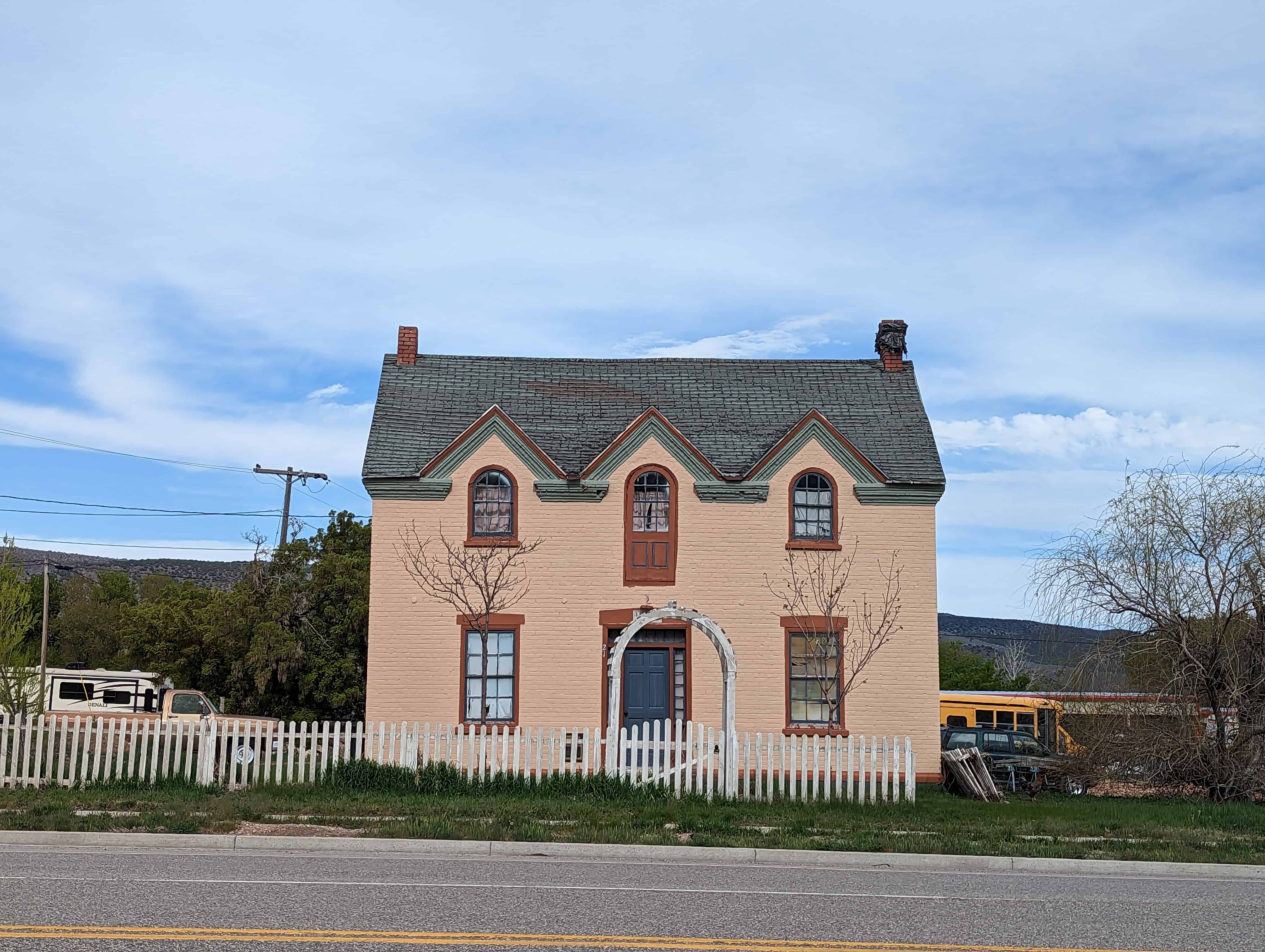
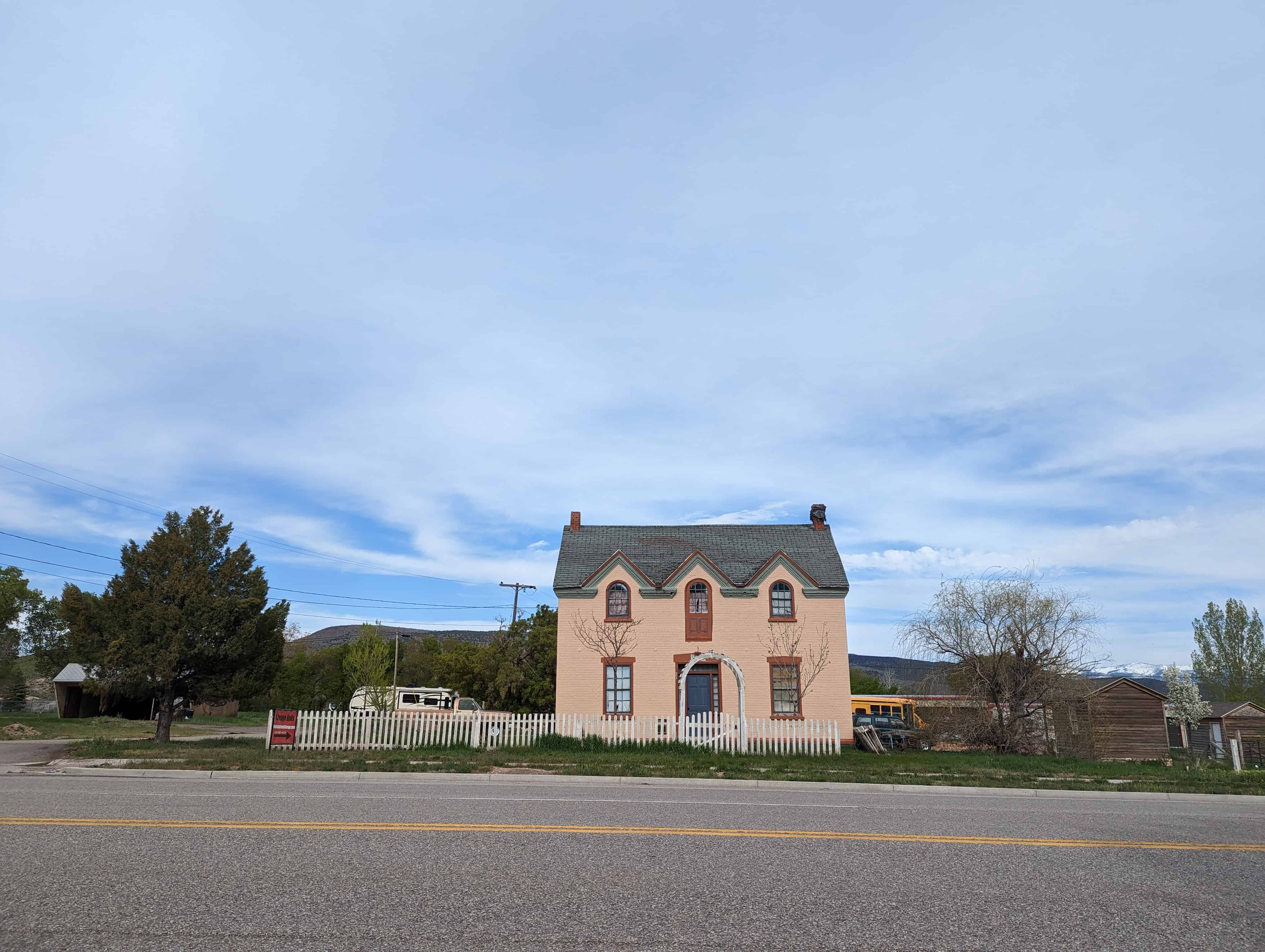
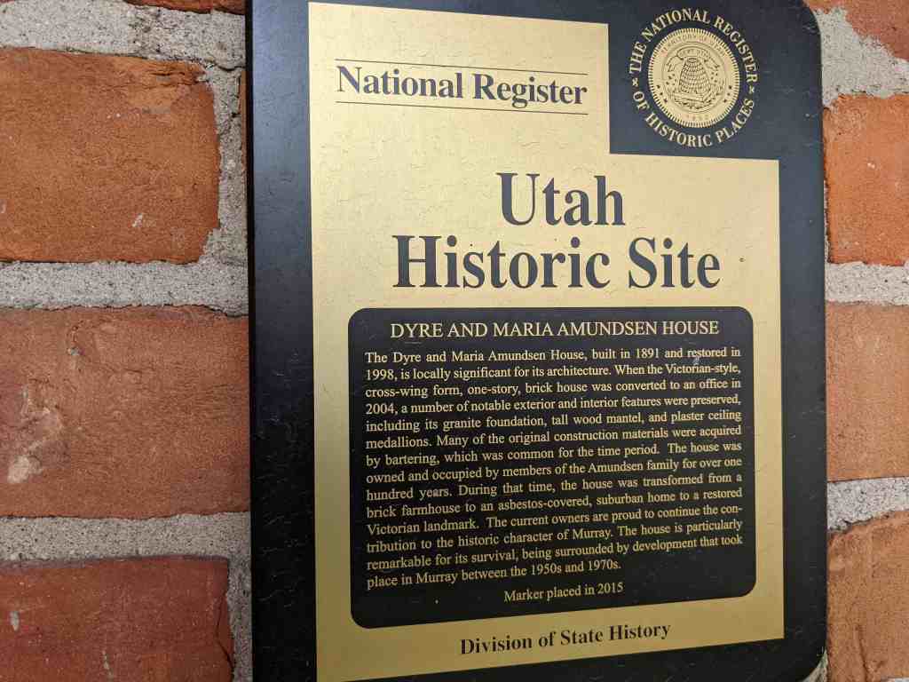
The Dyre and Maria Amundsen House, built in 1891 and restored in 1998, is locally significant for its architecture. When the Victorian-style, cross-wing form, one-story, brick house was converted to an office in 2004, a number of notable exterior and interior features were preserved, including its granite foundation, tall wood mantel, and plaster ceiling medallions. Many of the original construction materials were acquired by bartering, which was common for the time period. The house was owned and occupied by members of the Amundsen family for over one hundred years. During that time, the house was transformed from a brick farmhouse to an asbestos-covered, suburban home to a restored Victorian landmark. The current owners are proud to continue the contribution to the historic character of Murray. The house is particularly remarkable for its survival, being surrounded by development that took place in Murray between the 1950s and 1970s.
Located at 307 East Winchester Street in Murray, Utah and added to the National Historic Register (#15000131) on April 6, 2015.
The Dyre and Maria Amundsen House, built in 1891 and restored in 1998, is locally significant under Criterion C in the area of Architecture. Although the Victorian-style one-story brick house was converted to an office in 2004, a number of notable exterior and interior features have been preserved. These include the granite foundation, a tall wood mantel, and plaster ceiling medallions. The house was owned and occupied by members of the Amundsen family for over one hundred years. During that time, the house was transformed from a brick farmhouse for a major farmstead to an asbestos covered suburban home to a restored Victorian landmark. The house is particularly remarkable for its survival at the edge of an explosion of residential and commercial development that took place in Murray between the 1950s and 1970s. The period of significance dates from the construction of the house in 1891 to the remodeling in 1951. The house is a particularly elaborate early example of a cross-wing Victorian cottage in Murray, especially considering the construction materials were acquired by the barter system common for the time period. The property meets the registration requirements under the Multiple Property Submission, Historic Resources of Murray City, Utah, 1850–1967. The associated historic contexts are “Early Residential and Agricultural Buildings of Murray, 1850-1910” and the “Americanization of Murray’s Residential Architecture, 1902-1965.” The Dyre and Maria Amundsen House has good historic integrity and contributes to the historic character of its Murray neighborhood.
When the Amundsen House was built in 1891 in the Victorian Eclectic style, it did not have the visual complexity of contemporaneous homes in the fashionable urban neighborhoods of Salt Lake City. The house did have a simple elegance that was suited to its rural setting. The unknown builder used a modified cross wing plan and a variety of materials to achieve the visual interest that is characteristic of the Victorian-era domestic architecture in Utah. Dyre Amundsen helped to haul granite blocks for the construction of the Salt Lake City LDS temple and family oral tradition suggests that Amundsen was given permission to select cast-off blocks for personal use. Much of the wood used in the house came from locust trees that Dyre Amundsen planted in the late 1860s or early 1870s. The red and contrasting yellow bricks were likely produced at the local brickyard in Murray. The brick and windows were paid for by a one-acre crop of potatoes. The interior spaces in the south half of the house are larger than the typical house of the period. Family tradition states that Dyre Amundsen received the two large plaster ceiling medallion moldings from the LDS Church as payment for hauling the granite blocks. The brick moldings, granite blocks, ceiling medallions, wide corridors, are atypical for a Victorian-era cross-wing house of the period in Murray.
The Amundsen House as a product of the Victorian period marks a pivotal point in Murray’s history. The availability of kiln-dried brick in the 1860s and the coming of the railroad in the 1870s transformed Murray’s domestic architecture from vernacular buildings to Victorian forms with asymmetrical massing and a variety of texture. The Victorian cottage was the most popular house type in Murray between 1884 and 1910. Dyre and Maria Amundsen originally built an adobe house on their homestead in the late 1860s, then worked many years to afford the spacious brick home that built in 1891. In the post World War-II era, the old brick house may have seemed out-of-date as frame cottages and brick ranch houses were built on the former Amundsen homestead. The family had the house covered with asbestos siding in 1951 effectively suburbanizing it for the next generation. The 1996 to 1998 rehabilitation of the house restored much of the Victorian elegance and was awarded a Utah Heritage Foundation award in 1999.
Dyre Amundsen was born on June 11, 1837, in Gernserud Buskerud, Norway. The family name was Anunsen in Norway. Dyre immigrated to Utah in 1862. While helping to bring other immigrants across the plains in 1863, Dyre Anunsen met and married Beata Erickson, who died in October 1863, only a month after their marriage. Dyre was living in South Cottonwood in 1865 when he met Sophia Maria Person. Maria Person was born in Marna, Sweden, in 1833.2 She immigrated to Utah in 1864.
Dyre and Maria were married in October 1865.3 They lived with the Wheeler family until a small cabin was built for them on Andrew Hammer’s property. Their son, John David, was born in the cabin in December 1867. Dyre Anunsen served in Utah’s Black Hawk War in 1866 and was award a medal for his service. Sometime in 1867 or 1868, Dyre Anunsen claimed a homestead on land along the angled land that would become 6400 South. As a latecomer to the area, his homestead of 160 and 37/100s of an acre was in the shape of an upside down “T” and claimed in three separate parcels. Dyre built a two-room adobe house for his family where a daughter, Sarah Ann, was born in January 1870. A second daughter, Marinda, was born there in April 1873. The adobe house was located west of the later brick house. Dyre was a logger and a farmer. One of the first projects he completed on his homestead was planting a grove of locust trees. The family would later use the wood to build a barn, fences, and the woodwork in the brick house. On February 20, 1875, Dyre Anunsen was granted a land patent for his homestead property.
The Anunsen begin using the name “Amundsen” in the 1880s. In 1891, Dyre filed a deposition with Salt Lake County to change the name on his deeds. The brick house was built in 1891. The builder is unknown, but Dyre himself may have placed the granite foundation blocks that he acquired. The bricks, windows, and other building materials were paid for by an acre of potato crop. The plaster ceiling medallions were reportedly given to Dyre in payment for hauling some of the granite for the Salt Lake temple.4 The Amundsen house and property were at the southern edge of Murray City after annexation in 1905. Dyre Amundsen died on November 17, 1906. He is buried in the Murray Cemetery. At the time of his death, the homestead property had been reduced by more than a half. The land and its water shares were divided between Maria Sophia Amundsen and her three children. Both daughters, Sarah Ann Amundsen Jensen and Marinda Amundsen Boyce, had been married several years and were living in Idaho. In 1909, Maria Amundsen deeded her acreage to her son John David, but retained a life estate. Maria Sophia Amundsen died on August 9, 1918. Her funeral was held in the Grant Ward meetinghouse and she was buried in the Murray Cemetery.
John David Amundsen married Alma Pauline Janson on September 19, 1899. Alma was born in Sweden in 1860 and immigrated to Utah in 1897. On the 1900 census, John David (as David) and Alma are living with his parents, Dyre and Maria. David and Alma had three children: Alice Engre Sophia (born in 1901), Edith Selma Lenora (1903), and Wallace Janson (1906). In a letter describing the history of the house, Edith’s daughter-in-law, Linda Adams, wrote that “the house became two dwellings [Edith’s] parents occupying the three rooms on the West side and her grandparents the two rooms on the East.”5 Edith recalled the driveway was lined with “tall stately poplar trees” and her grandmother had planted the front yard with “yellow roses and Mormon tea vine.” The rest of the yard was planted with “as many shrubs as possible to keep the dust down.”6 David and Alma kept the land as productive as they could, raising vegetable, hay, and sugar beets.
The early settlement of the area began soon after the members of the Church of Jesus Christ of Latter-day Saints (LDS or Mormon) began arriving in the Salt Lake Valley in 1847. Mormon pioneers quickly spread out from Salt Lake City in search of suitable agricultural land. By 1848 a settlement in the area later known as Murray was established eight miles south of Salt Lake City. The settlement was first called South Cottonwood and was a community of scattered farmsteads originally extending from the Big Cottonwood Creek to the southern end of the Salt Lake Valley, east to the Wasatch Mountains, and west to the Jordan River. As more settlements were established in the south valley, the name South Cottonwood was retained by a group of farmers organized as the South Cottonwood Ward of the LDS Church. An adobe meetinghouse, located at the corner of Vine Street and 5600 South, was the community center for the group. The main north-south corridor was the Territorial Road (later State Street). The Salt Lake City & Jordan Canal and the East Jordan Canal were dug to bring water from the Big and Little Cottonwood Creeks to the farmsteads between South Cottonwood and the settlement of Union to the southeast.
The north half of the South Cottonwood did not remain rural. At the west end Vine Street, an industrial and commercial center began to grow in response to several smelters that were established near the railroad lines west of State Street in the early 1870s. In 1883, the name Murray (after the territorial governor, Eli Murray) was adopted for the town’s official postal designation. The name Murray became official during the incorporation of the city in 1903. At the time of incorporation the boundaries of the city extended from approximately 4500 South to 5600 South, and 900 East to 900 West. In 1905, the city boundaries were extended south to include both sides of 6400 South, which was the main east-west corridor and marked the south boundary of the historic South Cottonwood community.
During the first half of the twentieth-century, Murray City was an industrial town with its own power plant, water system, and school district. Residential development took place near the city center or along the major transportation routes, while the outlying areas continued as farmland. After the last remaining smelter closed in 1950, Murray City with its stable infrastructure and centralized location experienced a post-war suburban building boom. The population jumped from 5,740 in 1940 to 21,206 in 1970. Between 1946 and 1967, sixty seven subdivisions of mostly single-family ranch houses were platted within the boundaries of Murray City. In 1972, commercial property along State Street between 6100 and 6400 South was consolidated for the construction of the Fashion Place Mall. The opening of the mall was planned to coincide with the construction of the Interstate-215 belt route just south of 6400 South. Since the 1970s, the commercial development around the mall has spread along 6400 South east to 900 East. Only a few historic homes, such as the Dyre and Maria Amundsen House, remain to tell the story of the neighborhood’s agricultural past
The census indicates all three grown children were living at home in 1930. Alice worked as a stenographer, Edith was a saleslady for a dry goods store, and David and Wallace worked the farm. David deeded approximately eleven acres in the north half of the property to Wallace in 1931. Alice Amundsen died of influenza in May 1933. One month later, Edith Amundsen married Bronson Adams. Bronson Howard Adams was born in Beaver, Utah, in 1908. Bronson and Edith moved away for a short time, but returned to live at the Amundsen House in 1934. It would be the only time in her life that Edith did not live in the family house on 6400 South. Alma Pauline Janson Amundsen died in February 1936. John David Amundsen died in December 1939. That year, Wallace Amundsen, who remained a bachelor, gave Edith his share of the property with the family home. Wallace Amundsen was living with Edith’s family on the 1940 census, but later moved to an adjacent home at 353 E. 6400 South. He died in 1979.
Edith and Bronson Adams had three children, Kathleen, Patricia, and Howard. Bronson worked in sales and as a warehouseman before starting a career with the Union Pacific Railroad. In July 1949, Bronson Howard Adams died during an operation at the age of forty. In order to care for her family and pay the taxes, Edith sold off much of the family property by the mid-1950s. The covering of the brick house in asbestos shingles in 1951 occurred just after the first postwar subdivision in the south half of Murray was developed between 1946 and 1950. Two of the largest subdivision developments in Murray, Murray Dale and the Murray Dale Addition, were platted in 1953 and 1954, north and east of the Amundsen house on land that was formerly part of the Amundsen farmstead. Edith Adams graduated from the Salt Lake Business School and worked for the Frank Edward Company until her retirement in 1970. When she passed away on October 15, 1995, she was recognized as a lifelong resident of Murray. After her death, her son Howard and his wife Linda, restored the family home. They were assisted by Dan Lossee, a local architect. The home was rented intermittently by family members and others before being sold to Tamra Lee, the owner of the Mt. Olympus Title Company in 2004.9 Although a busy title company office, the house maintains its domestic charm.
Narrative Description
The original footprint of the Amundsen House is a rectangle of 40 feet by 26 feet with a six-foot projecting wing at the southwest corner. The foundation is made from large rock-faced granite blocks. The red brick is laid in a common (American) bond with headers every seventh course. The mortar joints are flush and are a contrasting light tan. There is plain wooden frieze (painted tan) under the eaves. The west projecting wing has a hipped roof. The main wing runs west to east with a simple gable that has been extended to the north. The bell cast extension of the roof above the front porch was made during the 1998 renovations. The wood shingles were installed at the same time. The south projection has two narrow Victorian windows with ornamental drip hood moldings of segmented and corbelled brick in a contrasting tan color. The sills are corbelled rowlock brick. The moldings and the original wood sills were damaged and replaced in 1998.
The current wood windows were installed in 1998, but are similar to the original one-over-one, double-hung windows, which were too damaged to repair. The west elevation has three openings with similar windows with a pair in the center. The treatment of the front door and two windows on the main wing’s façade are the same. The half-glass front door with transom is original, although the glass has been replaced with decorative leadedglass. The front porch is the only major modification to the façade. It is full width rather than the entrance-only porch of the original and wraps around the east side to the bay addition. The new Victorian-style porch features a concrete base with a wood plank deck. The slender lathe-turned posts and balustrade were installed in 1998, but are compatible with the Victorian-style.
The north half of the house was slightly lower and set back on the east elevation. Tax records indicate that by the late 1930s, the house had a 9 feet by 14 feet lean-to addition and a 5 by 7 feet screened porch on the rear elevation. The original east elevation had two windows, one in the taller south half and one in the shorter north half. The rear porch was enclosed and expanded around 1951 when the entire house was clad in pink asbestos siding. The 1951 remodeling included wood surrounds for each opening and wrought-iron supports over the front stoop. In 1996, the siding was removed. The rehabilitation of the house was completed in 1998 including installing a new roof, cleaning the brick, and installing the replacement wood windows. The brick chimney at the center of the house was originally much taller with a corbelled cap. In 1951, it was shortened, but is still operable. A compatible brick addition on a concrete foundation was designed to replace the rear lean-to and enclosed porch addition. A new bay window has altered the historic footprint along the east elevation. The addition matches the details on the original house, but can be distinguished by the use of newer materials.
On the interior, the Amundsen House has 1,844 square feet of space on the main floor. The house has no basement or cellar. The attic space is not useable. The interior features an unusually wide central passage and 12-foot-high ceilings. The parlor to the west features the original carved wood mantel with a mirror inset. The hearth and firebox was replaced with stone tile in 1998. Other original woodwork such as the fluted and paterae window casings and the tall baseboards are intact. The ornamental plaster ceiling medallions in the parlor and living room are original, but the light fixtures are period antiques that were obtained from the Hotel Utah in Salt Lake City. Behind the parlor is the original home’s only bedroom (closet added in 1998). The kitchen is north of the living room on the east side of the house. The east projection, built in 1998, is a conference room. The wallpaper was selected to match the original as seen in family photographs. The French doors and newer woodwork match the style of the original features. The bathroom at the north end of the hall was moved to the east, to provide access for the rear addition. The addition features two rooms and a central bathroom. The spaces have been used for offices since 2004; however, the house could be returned to residential use.
The current 0.53 acre site is only a fraction of the original 160-acre homestead. The unusual shape of the parcel is partially a result of a number of factors: subdivision development to the north, substation expansion to the west, and the busy Winchester Street (6400 South) and Fashion Boulevard intersection, which leads to the Interstate-215 interchange. The driveway originally accessed 6400 South, but was reconfigured in 1998 to provide access from 300 East. The contributing 1930 frame one-car garage is located northeast of the house.1 The space between the concrete driveway and 6400 South is landscaped with evergreens and bark. There is lawn on three sides of the house. There is a large vegetable garden plot in the northeast portion of the lot. Fencing is a combination of brick pier, white vinyl, and chain link.
The immediate neighborhood is a mix of large-scale commercial and single-family residential. The Fashion Place Mall (1972) is directly west of the substation and commercial development has spread along the south side of Winchester Street. On the north side of Winchester Street are historic homes, mostly from the 1940s. The neighborhood north and east of the Amundsen property is a subdivision that was developed in the mid to late 1950s. The original setting of the house has been somewhat compromised by later development, but the house has integrity of location. Minor alterations were made to the design and materials of house in 1998, but the house retains high integrity in terms of workmanship, feeling, and association of the original Victorian-style brick house. Because of its surroundings, the restored Dyre and Maria Amundsen House is a distinctive landmark and a contributing resource in its south Murray neighborhood.