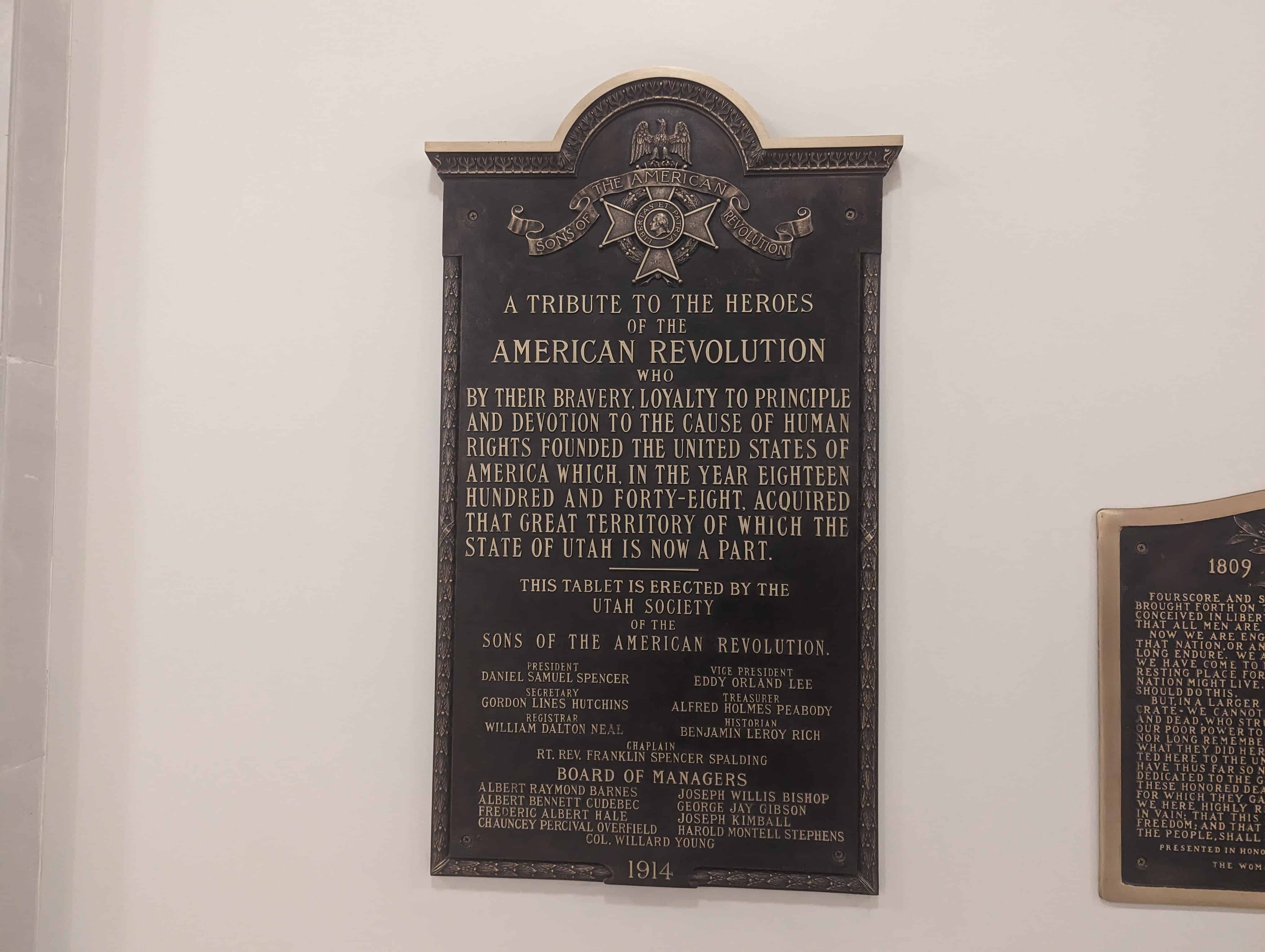
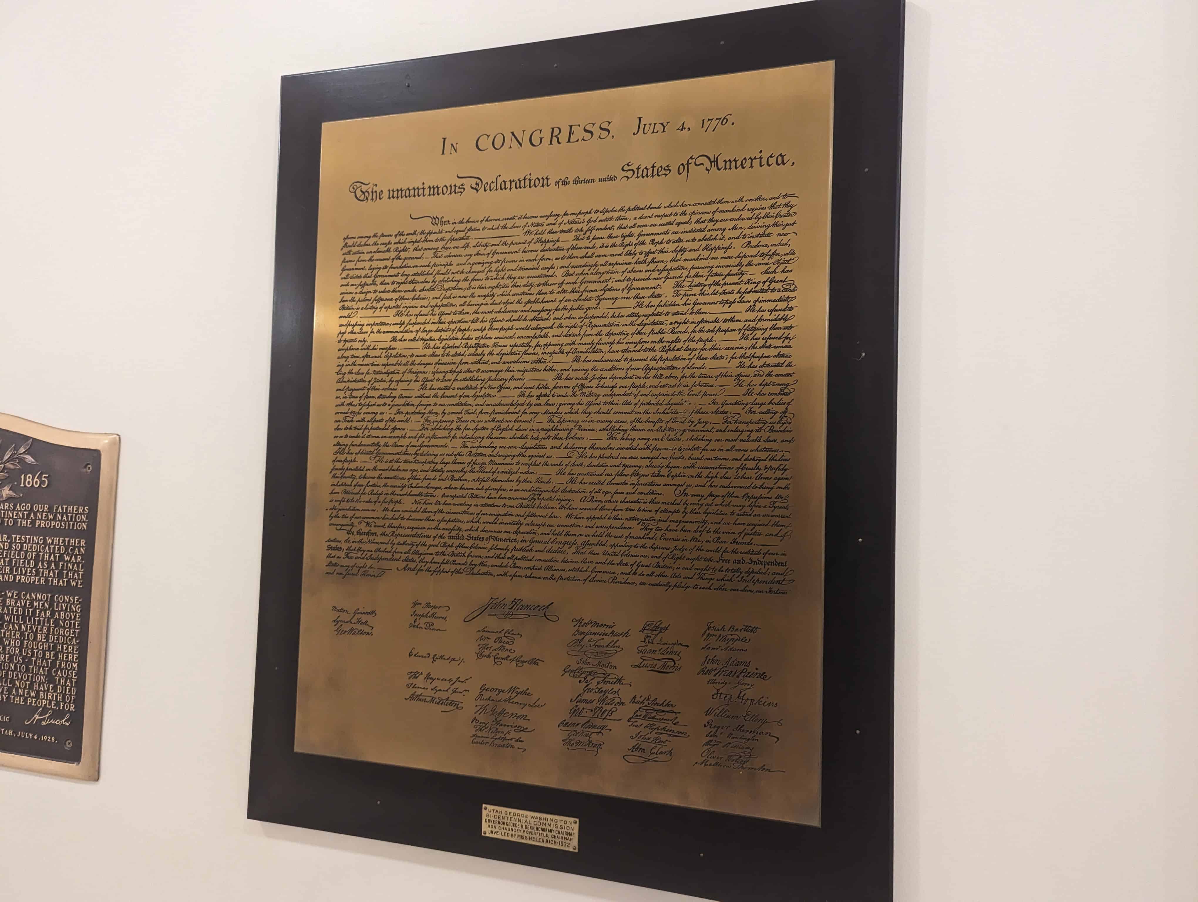
• About JacobBarlow.com
  • Cemeteries in Utah
  • D.U.P. Markers
  • Doors
  • Exploring Utah Email List
  • Geocaching
  • Historic Marker Map
  • Links
  • Movie/TV Show Filming Locations
  • Oldest in Utah
  • Other Travels
  • Photos Then and Now
  • S.U.P. Markers
  • U.P.T.L.A. Markers
  • Utah Cities and Places.
  • Utah Homes for Sale
  • Utah Treasure Hunt

JacobBarlow.com

~ Exploring with Jacob Barlow

JacobBarlow.com

Tag Archives: utah

Castle Rock, Utah

23 Monday Nov 2015

Posted by Jacob Barlow in Uncategorized

≈ 5 Comments

Tags

Echo Canyon, summit county, utah

  • 4a5ad825-4f6d-42db-b6ce-bc92c0ad21cf

In 1860 a pony express station was built here which started the town. A school was built in 1872 and continued until 1937.

The site of the former town of Castle Rock and the former Pony Express Station is at N 41.11238 W 111.20466, a little down the canyon from the current junkyard and freeway exit with the same name.

Head of Echo Canyon(*)

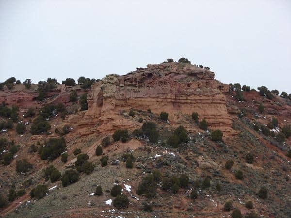
The station at the head of Echo Canyon was also known as Frenchies and Castle Rock. It was a contract station on the Pony Express and Stage route. Jabusch believes that the station originally stood in the abandoned town called Castle Rock, which was located about a mile and a half down the canyon from the present junk yard site known as Castle Rock. The structure was apparently built of logs, and after being sold to a French trapper in 1867, was moved up to the canyon to the junk yard site, owned in recent years by the late Curtis Moore.Traveler and author Horace Greeley did not enjoy the ride through Echo Canyon. His description:

“The canyon reminded me afresh that evil and good are strongly interwoven in our earthly lot. Throughout the desolate region which stretches from the Sweetwater River nearly or quite to Bridger, we had in the main the best natural road I ever traveled…. But in this fairly-grassed ravine, hemmed in by steep, picturesque bluffs… we found the ‘going decidedly bad,’ and realized that in the dark it could not be but dangerous.”

Burton, who often found little to praise on the western frontier, seemed to be fascinated with the “picturesque bluffs.” Despite a team of unbroken and rather fractious mules he wrote,

“A whole Petra was there, a system of projecting prisms, pyramids, and pagoda towers, a variety of form that enabled you to see whatever your peculiar vanity might be; columns, porticoes, facades and pedestals. Twin lines of bluffs, a succession of buttresses all fretted and honey-combed, a double row of steeples slipped from perpendicularity, frowned at each other across the gorge. And the wondrous variety was yet more varied by the kaleidoscopic transformation caused by change of position: at every different point the same object bore a different aspect.”Echo Canyon has but one fault: its sublimity will make all other similar features look tame.”

Back to the southeast, and unfortunately on private land, one finds the well-known trail landmark called Cache Cave. The cave was a popular camping spot on the emigrant trail, and, high up on the cave walls where livestock cannot rub, the names of many Mormon Pioneers can still be seen.Information provided by Patrick Hearty, NPEA Utah, 2005.

Utah State Capitol

23 Monday Nov 2015

Posted by Jacob Barlow in Uncategorized

≈ 14 Comments

Tags

Capitol Buildings, historic, Historic Buildings, Salt Lake City, Salt Lake County, utah

2018-09-01 12.01.20

The Utah State Capitol is the house of government for the U.S. state of Utah. The building houses the chambers and offices of the Utah State Legislature, the offices of the Governor, Lieutenant Governor, Attorney General, the State Auditor and their staffs. The capitol is the main building of the Utah State Capitol Complex, which is located on Capitol Hill, overlooking downtown Salt Lake City.

Related posts:

  • Abraham Lincoln
  • Blossom photos
  • Brigadier General Richard W. Young
  • Brigham Young Statue
  • Capitol architect Richard K.A. Kletting
  • Capitol Hill Historic District
  • The Capitol Lions
  • Capitol Murals
  • Chief John Duncan
  • David Abbott (Ab) Jenkins
  • Inside the Capitol Dome
  • Emmeline B. Wells
  • George Edward Wahlen
  • Martha Hughes Canyon
  • Maurice Warshaw
  • Mormon Battalion Monument
  • Original 1916 Capitol Dome Light
  • Original Lion Sculpture
  • Simon Bamberger
  • Statue of Massasoit
  • Philo Taylor Farnsworth
  • Unca Sam
  • U.S.S. Utah Memorial
  • Utah. America’s Film Set. (Event)
    • Utah Filming Location Regions
  • Utah Liberty Bell Replica
  • U.P.T.L.A. # 19 – In Tribute to the Utah Pioneers
IMG_20180409_195146-EFFECTS
picture24nov07-205
2018-09-01 11.53.03
20160702_154421-EFFECTS

The Neoclassical revival, Corinthian style building was designed by architect Richard K.A. Kletting, and built between 1912 and 1916. The building was added to the National Register of Historic Places in 1978. Beginning in 2004, the capitol underwent a major restoration and renovation project. The project added two new buildings to the complex, while restoring many of the capitol’s public spaces to their original appearance. One of the largest projects during the renovation was the addition of a base isolation system which will allow the building to survive as much as a 7.3 magnitude earthquake. After completion of the renovations, the building was rededicated and resumed normal operation in January 2008.

The gold room.
2017-08-05 16.42.28
2017-08-05 16.44.08
2017-08-05 16.47.10
2017-08-05 16.47.41
2017-08-05 16.47.59
IMG_20141231_235702

Clyde Park

20 Friday Nov 2015

Posted by Jacob Barlow in Uncategorized

≈ 2 Comments

Tags

Mapleton, Parks, utah, utah county

  • picture12mayr08-051

Clyde Park in Mapleton, Utah. The area was called “Jap’s Hill” when I was a kid and was a really fun place to do some off road mountain biking. It was turned into a park in 2008.

Related:

  • The Clyde Home was located here.
  • ingress_20130922_172540_0

Manderfield, Utah

19 Thursday Nov 2015

Posted by Jacob Barlow in Uncategorized

≈ 2 Comments

Tags

Beaver, Beaver County, Manderfield, utah

2018-11-20 13.26.04

Manderfield, Utah, just north of Beaver and the birthplace of Philo Taylor Farnsworth  who was an American inventor. He is best known for inventing the first completely electronic television. In particular, he was the first to make a working electronic image pickup device (video camera tube), and the first to demonstrate an all-electronic television system to the public.

2018-11-20 13.26.38
2018-11-20 13.32.06
picture01march08-019
picture01march08-018

Sphinx in Utah

19 Thursday Nov 2015

Posted by Jacob Barlow in Uncategorized

≈ Leave a comment

Tags

Art, Salt Lake City, Salt Lake County, utah

008fd6ab-b412-452a-ae7a-d85358321f33
616ff755-ec40-4a56-bb2f-2f999ca7442e


Some of the Sphinx I have come across in Utah. These two are in Downtown Salt Lake City, the Masonic Temple and Gilgal Garden.

Park City, Utah

19 Thursday Nov 2015

Posted by Jacob Barlow in Uncategorized

≈ 21 Comments

Tags

park city, summit county, utah

6008826291_2f04be586a_z

Park City Related Posts:

  • Alpine Slide and Park City Mountain Coaster
  • Crescent Tramway
  • Glenwood Cemetery
  • High School Mechanical Arts Building
  • Kimball Stage Stop
  • Library / Old High School
  • Marsac School / City Hall
  • Ontario / Judge Mill and Mine
  • Park City Cemetery
  • Park City City Parks
  • Park City Community Church
  • Park City LDS Meeting House
  • Park City Main Street
  • Park City Miner’s Hospital
  • Park City Museum
  • Park City Pioneers
  • Snyderville Pioneer Cemetery DUP Marker and SUP Marker
  • St. Mary of the Assumption Church and School
  •  
  • Park City, sorted by address
2016-07-28-16-24-06
ingress_20130523_143257_0

The transformation of the town into a ski resort is primarily attributed to the silver need during (and after) World War I economy. The war and Great Depression were crippling the economy. Once the site of the largest silver-mining camp in the country, the town was virtually destroyed by fire in 1898. Tragedy struck again in 1902 when 34 miners were killed in an explosion in the Day West Mine. The mining community never fully recovered and the miners resorted to desperate measures. These desperate measures were based on the need to revive the economy, and in doing so the miners gave up their mining heritage, turning to the rising interest in the West and skiing. The silver industry was suffering severely, and the town was hanging by a thread when ‘Parkite’ miners presented to Utahns Inc. a proposal for a ski resort called Treasure Mountain which ended up saving the town. This ski resort opened in 1963 on 10,000 acres of land the miners owned with mineral rights. This is said to be when tourists first largely began to visit Park City. This marks the beginning of the ski industry largely promoted by the Utah State Legislation as a destination resort.

picture12aug08-035

Since the rise of the skiing and tourist economy, Park City houses more tourists than residents. It has become a place of fame through the 2002 Winter Olympic games and provides more attractions than ever before. In the 1950s, Utah began to feed on Park City as a mountain getaway, and not until D. James Canon promoted winter sports in Utah, with the promotional scheme of “Ski Utah” and “The Greatest Snow on Earth” did many drive to see the city. Utah drew in over 648,000 tourists in 1970 and now a yearly average of 4 million tourists. In a small town with a population of 8,000, the average number of tourists in Park City is 600,000 per year. This significant increase in visitors could be credited to promotional material that is carefully planned and distributed by the Utah Publicity and Tourist Council. Growth has accelerated in the last few decades, and Park City is now one of the most affluent and lively resort towns in the United States.

The tourist industry now contributes over one third of the total economic value to the state of Utah. In particular, Park City draws in 3,006,071 average annual visitors; in the winter 1,603,775, and in the summer 1,402,296. Park City prospers from the average nightly visitor spending ranging from $100 to $350. Currently, Park City primarily relies on its tourist industry from skiing to restaurants to hiking and biking. The makeover of Park City has stimulated an entirely different culture of expenditure, adventure, and wealth, and their promotional material indulges it.

As long ago as the 1920s, miners in Park City were using underground trains and shafts to gain access to the mountain for skiing. Aerial trams once used for hauling ore were converted into chairlifts. To this day, there are still more than 1,000 miles of old silver-mine workings and tunnels beneath the slopes at Park City Mountain Resort and neighboring Deer Valley. Park City might be a fairly nondescript-appearing town were it not for its colorful and evocative Main Street, where 64 Victorian buildings are listed in the National Register of Historic Places. There are many remaining mine buildings, mine shafts (most blocked off from outsiders with large steel doors), and hoists, including the weathered remains of the California-Comstock and Silver King Mines and the water towers once used to hydrate one of the biggest mines, the Silver King, provide a hint of the history of this mining town transformed in economic upheaval into a skiing resort.

Slip & Slide

17 Tuesday Nov 2015

Posted by Jacob Barlow in Uncategorized

≈ 1 Comment

Tags

Geology, Provo Canyon, utah, utah county

3cac670d-7cdc-4100-9301-968f2b334a18
e6af762c-99e3-474f-bf87-cb9cf33fb654


Slip & Slide – Landslides

Over the years, the slide area above you has been very problematic, in 1986, a landslide moved the pipeline.  The slide eventually covered and crushed the pipeline.

Because of the active nature of the slide, the pipeline was eventually moved from the hillside, and the water now flows through a tunnel undernearh the active landslide.

Historic Allphin House

26 Monday Oct 2015

Posted by Jacob Barlow in Uncategorized

≈ 1 Comment

Tags

Granite, historic, Historic Homes, Salt Lake County, Sandy, utah

Peggy Allphin Ogborn was telling me some of the history of this house, I stopped to get photos and will need to get the stories written up and added here.

It’s at 3245 9600 S, Sandy, UT 84092

2014-09-01 16.17.11

2014-09-01 16.17.14

2014-09-01 16.18.01

2014-09-01 16.18.03

2014-09-01 16.18.23

2014-09-01 16.18.43

2014-09-01 16.18.59

2014-09-01 16.19.39

2014-09-01 16.20.25

Alta, Utah

26 Monday Oct 2015

Posted by Jacob Barlow in Uncategorized

≈ 2 Comments

Tags

Alta, Little Cottonwood Canyon, Salt Lake County, utah

  • 2017-09-17 16.28.30

Silver ore was first discovered here in 1864. By 1873 there were 26 saloons in town. The town was called Alta because of its altitude. The population was upwards of 5000 people at times. The mines ran out and by 1895 the town was a ghost. A few of the mines were re-opened again in 1904 and worked until 1936. The old town sight of Alta is now a ski resort. Boiler Basin got its name because of a boiler that was left there after a train crash. Most people think that the train crash was the end of the train service in Alta but that is not true. A car was converted to run the cog railway line to transport people to Alta after the train crash.

Related posts:

  • Historic Bay City Tunnel
  • Little Cottonwood Canyon
  •  
  • 2017-09-17 16.28.25
  • 2017-09-17 16.24.46
  • 2017-09-17 16.24.02
  • 2017-09-17 16.22.50
  • 2017-09-17 16.22.39
  • 2017-09-17 16.22.32
  • 2017-09-17 16.22.28
  • 2017-09-17 16.22.22
  • 2014-09-01 15.39.44
  • 2014-09-01 15.39.48
  • 2014-09-01 15.48.19
  • 2014-09-01 15.54.14
  • 2014-09-01 15.54.18

Temple Quarry Site

26 Monday Oct 2015

Posted by Jacob Barlow in Uncategorized

≈ Leave a comment

Tags

historic, Little Cottonwood Canyon, Mining, Salt Lake County, utah

2014-09-01 14.26.42
2014-09-01 14.26.50
2014-09-01 14.27.00
  • 2014-09-01 14.27.07
  • 2014-09-01 14.27.16

UPTLA#49
The granite used in the construction of the Mormon Temple in Salt Lake City was quarried from a large field of huge boulders covering this area broken by nature’s forces from adjacent cliffs. The quarrying of these boulders was begun about 1862 by James C. Livingston, under supervision of John Sharp. The names of the faithful quarrymen who continued the work until the Temple was finished in 1893 are enclosed in the monument. Rough stones were hauled about twenty miles to the temple site suspended under great two wheel carts drawn by ox-teams, until the railroad was built in 1872.


The monument was refurbished and moved in 2004 to its current location by the Temple Quarry Chapter of the SUP.

See other historic markers in the series on this page for UPTLA/SUP Markers.

2014-09-01 14.27.52
2014-09-01 14.29.50
2014-09-01 14.30.39
2014-09-01 14.31.06
2014-09-01 14.31.12
2014-09-01 14.33.24
2014-09-01 14.33.29
2014-09-01 14.34.43
2014-09-01 14.34.50
2014-09-01 14.37.51
2014-09-01 14.42.41
2014-09-01 14.42.47
2014-09-01 14.43.00
2014-09-01 14.43.33
2014-09-01 14.44.53
2014-09-01 14.44.58
2014-09-01 14.45.32
2014-09-01 14.45.36
2014-09-01 14.45.38
2014-09-01 14.50.37
2014-09-01 14.50.40
2014-09-01 14.51.35
2014-09-01 14.51.42
2014-09-01 14.51.46
2014-09-01 14.51.55
2014-09-01 14.52.07
2014-09-01 14.52.09
2014-09-01 14.54.22
← Older posts
Newer posts →

Follow Jacob

Follow Jacob

Blog Stats

  • 2,084,901 hits

Social and Other Links

BarlowLinks.com

Recent Posts

  • Provo High School Seminary Building
  • 821 E 100 S
  • 820 E 100 S
  • 817-819 E 100 S
  • 814 E 100 S

Archives

Loading Comments...