• About JacobBarlow.com
  • Cemeteries in Utah
  • D.U.P. Markers
  • Doors
  • Exploring Utah Email List
  • Geocaching
  • Historic Marker Map
  • Links
  • Movie/TV Show Filming Locations
  • Oldest in Utah
  • Other Travels
  • Photos Then and Now
  • S.U.P. Markers
  • U.P.T.L.A. Markers
  • Utah Cities and Places.
  • Utah Homes for Sale
  • Utah Treasure Hunt

JacobBarlow.com

~ Exploring with Jacob Barlow

JacobBarlow.com

Tag Archives: utah

Verdure

10 Tuesday Jun 2014

Posted by Jacob Barlow in Uncategorized

≈ 1 Comment

Tags

DUP, historic, San Juan County, utah, Verdure

picture24jul07-077

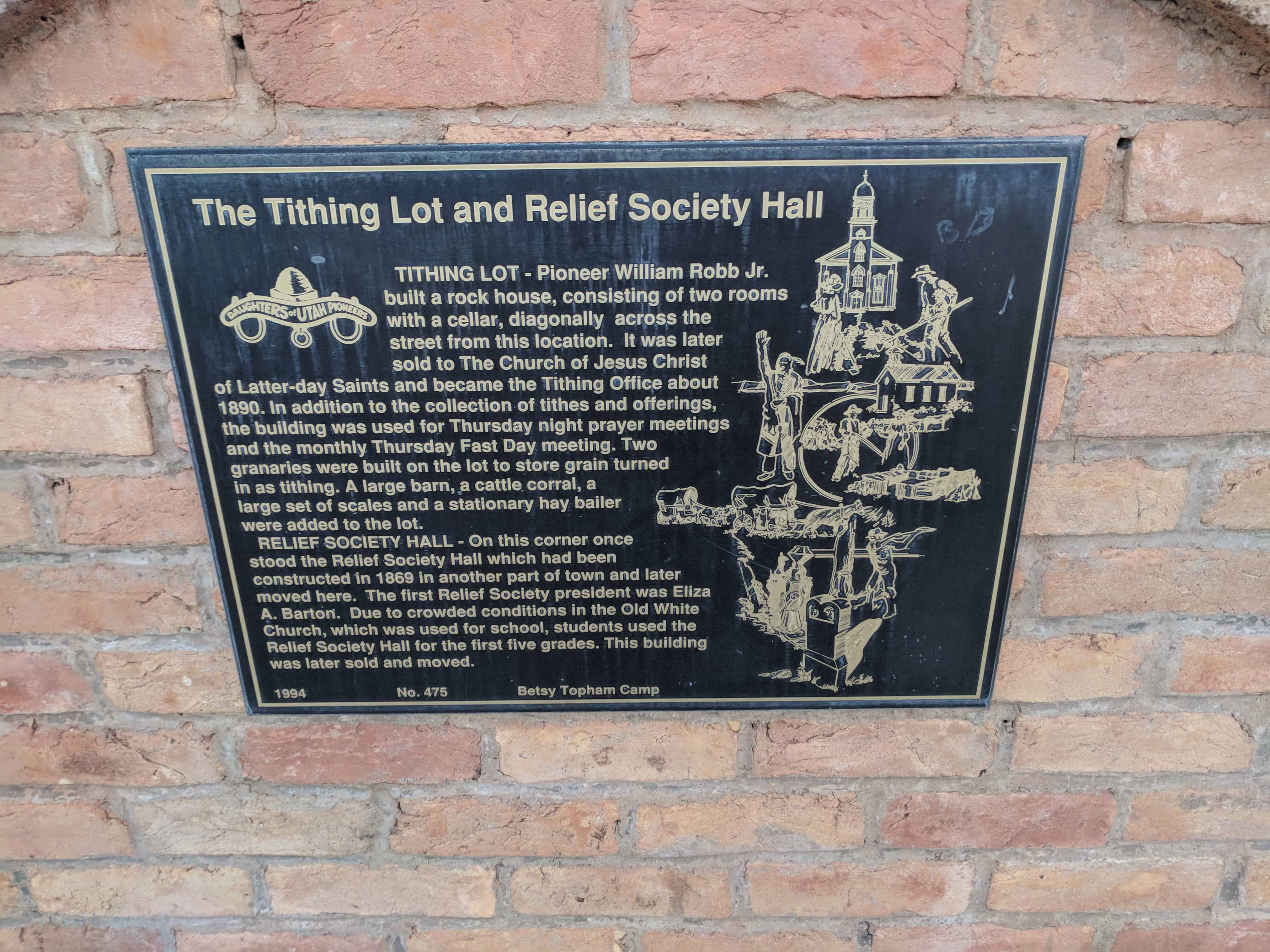
The oldest Mormon settlement in the Blue Mountain Region was first known as South Montezuma. Later the name was changed to Verdure after the lush green growth along the stream bed. Verdure was settled by men of the Blue Mountain Mission March 11, 1887, under the direction of Pres. Francis A. Hammond of the San Juan Stake. He called George A. Adams, Frederick I. Jones, Parley R. Butt and Charles E. Walton to establish a new settlement at North Montezuma, later named Monticello. They first set up camp at Verdure to prepare for a permanent settlement at Monticello, six miles to the north.

When company members moved on to Monticello in 1888 the Adams and Butt families remained at Verdure. By 1894 they were joined by the Alvin Decker, Willard Butt, Lingo Christensen, R.P. Hott and Francis Nielson families. Nielson operated a store and a school out of his log home, the first church met in the Decker home, and in 1893 a post office was installed in the Adams home.

Verdure was a peaceful frontier village where cattle, farming and cheese-making were the main occupations. Gradually the settlers moved to Monticello.

2017-03-12 16.46.24
2017-03-12 16.46.24-1

Check out all of the historic markers placed by the Daughters of Utah Pioneers at JacobBarlow.com/dup

Enoch Schoolhouse and Tithing Office

10 Tuesday Jun 2014

Posted by Jacob Barlow in Uncategorized

≈ 1 Comment

Tags

DUP, Enoch, historic, Iron County, utah

picture01oct07-034

SCHOOLHOUSE – The second schoolhouse in Enoch was a two-story structure built on this site in 1917-1918. It was a brick building containing two classrooms, two libraries, two bathrooms and a furnace room. Only one room served as a classroom, and one was sometimes used as a playroom during the winter. Between twenty and thirty students a year attended this school in grades one through six. The building was used until Iron County bussed the students from Enoch to Cedar City. It was torn down some years later.

TITHING OFFICE – On the site across the street and one-half block to the west are the remains of the Bishop’s storehouse and tithing office. The wooden building, 20 feet by 17 feet 9 inches, had a tall peaked roof, an outside staircase, and looked like an ordinary granary. It contained bins both in the basement and on the main floor. These bins were used to store grain, potatoes and other crops that were brought in as tithing payments. Tithing produce was used to help those in need. Sometimes seed, such as wheat, was loaned to the farmers at planting time to be paid back after the harvest.

picture01oct07-036

Check out all of the historic markers placed by the Daughters of Utah Pioneers at JacobBarlow.com/dup

Salem’s First Post Office

10 Tuesday Jun 2014

Posted by Jacob Barlow in Uncategorized

≈ Leave a comment

Tags

DUP, historic, Payson, Salem, utah, utah county

This log cabin was used as the first Post Office in Salem. It was built on the east bank of the Salem Pond by George Killiam, who served as postmaster from March 1, 1872 to 1877. Harry Nelson then purchased the cabin, moved it to the southeast part of Salem, and used if for a summer home. It was later sold to Chris Nelson, his brother, whose children played there until 1937, when it was purchased by the Daughters of Utah Pioneers. The cabin was next moved to a location northwest of the chapel of The Church of Jesus Christ of Latter-day Saints. On March 19, 1972, the cabin was moved to the southwest corner of the church lot when a new LDS Chapel was built. It has now been moved to the west bank of the Salem Pond at 13 South 300 West, renovated and furnished with pioneer artifacts.

The text above is from Daughters of Utah Pioneers historic marker #479, located at Salem Pond at 99 South 300 West in Salem, Utah

  • D.U.P. Historic Markers
Image
Image

A Pioneer Home

10 Tuesday Jun 2014

Posted by Jacob Barlow in Uncategorized

≈ Leave a comment

Tags

DUP, historic, Salt Lake City, Salt Lake County, utah

 Image


This marker is supposed to be at the old Pioneer Cabin across the street to the west from Temple Square, (see this post) but in searching it out I found out it was in storage at the DUP Museum across the street from the State Capitol.   I went there and got the pictures. 

The location when they get it placed back at the cabin will be: N 40 46.235′ W 111 53.682′

The location now, the Museum is at: N 40 46.591′ W 111 53.468′


The Marker reads: One of the oldest houses in Utah, built in September 1847, by Osmyn m. and William H. Deuel, located North of the east portal of the old fort, now Pioneer Park.  In 1849 Albert Carrington bought and moved it to 1st North and West Temple.  He presented it to his daughter Frances, when she married Zebulon Jacobs.  In 1912 they gave it to the Church.  It was moved to the museum in the Vermont Building and later to this site.  Albert Carrington was assistant to Capt. Stansbury during his U.S. Survey in 1849-50.  Part of Stansbury’s time was spent in this cabin.


Image

Check out all of the historic markers placed by the Daughters of Utah Pioneers at JacobBarlow.com/dup

The Tithing Lot and Relief Society Hall

09 Monday Jun 2014

Posted by Jacob Barlow in Uncategorized

≈ 2 Comments

Tags

DUP, historic, Iron County, Paragonah, utah

picture01oct07-050

TITHING LOT –

Pioneer William Robb Jr. built a rock house consisting of three rooms with a cellar, diagonally across the street from this location. It was later sold to the Church of Jesus Christ of Latter-day Saints and became a tithing office about 1890. In addition to the collection of tithes and offerings, the building was used for Thursday Night prayer meetings and the monthly Thursday Fast Day meeting. Two granaries were built on the lot to store grain turned in as tithing. A large barn, a cattle corral, a large set of scales and a stationary hay bailer were added to the lot.

RELIEF SOCIETY HALL –

On this corner once stood the Relief Society Hall which had been constructed in 1869 in another part of town and later moved here. The first Relief Society president Eliza A. Barton. Due to crowded conditions in the Old White Church, which was used for school, students used the Relief Society Hall for the first five grades. This building was later sold and moved.

Located in Paragonah.

picture01oct07-048

2018-02-18 18.12.51

2018-02-18 18.12.56

2018-02-18 18.13.00

Check out all of the historic markers placed by the Daughters of Utah Pioneers at JacobBarlow.com/dup

La Verkin Canal

09 Monday Jun 2014

Posted by Jacob Barlow in Uncategorized

≈ 1 Comment

Tags

DUP, historic, La Verkin, utah, Washington County

picture13oct07-056

La Verkin Canal

In December of 1888, Thomas P. Cottam and Thomas Judd made a preliminary survey to determine the probable cost of a canal. Early in 1889, Isaac C. MacFarlane made a working survey, and work was started as soon as his survey was completed.

In June of 1889, the La Verkin Fruit and Nursery Company was incorporated to establish nurseries, orchards, and vineyards and to promote fruit raising, stock raising and general farming, all of which would be benefited by the canal.

The building of this canal was difficult. The canal leaves the Virgin River on the north side about two and one-half miles above the La Verkin hot springs and follows along the precipitous canyon walls for about a mile and a half. The ditch then enters a tunnel through the mountains for about nine hundred feet opening out upon the La Verkin bench. Because most of the canal is built in the rocks, the builders felt it was completely secure.

The first years were difficult because the patches of gypsum in the rocks in the ditch constantly melted away, both in the canyon and in the tunnel. Lack of water when it was most needed threatened to make the project a complete loss. Leaks were plugged with rocks and then “pulled” with dirt. Cotton lint from the Washington Factory, straw, and bagasse were used without much success. Finally the worst places were flumed with lumber, and water became more certain. Water was vital to the western pioneers. The La Verkin canal was an extremely difficult, but successful, solution to this problem.

picture13oct07-055

Related:

  • D.U.P. Historic Markers

Located at 481 North Main Street in La Verkin, Utah

Oak City

09 Monday Jun 2014

Posted by Jacob Barlow in Uncategorized

≈ 1 Comment

Tags

DUP, historic, Millard County, Oak City, utah

  • Image

Oak City was named after Oak Creek, a sparkling mountain stream meandering through scrub oak and gray sagebrush. It provided water, the life blood, of this community.

Founded in 1868 by pioneers who had formerly resided at Deseret, this location was chosen as a refuge from the Sevier River floods. Their animals formerly had been pastured on Oak Creek. The town site was surveyed into twenty-four blocks and was patterned after the original survey of Salt Lake City. Lots were drawn for the property. Families began the wagon trek bringing with them doors and windows from their homes in Deseret. Others completely dismantled their houses there and hauled the material to the new settlement and reassembled it on their newly acquired land.

The season was late, near November. Twenty-three families hauled logs from the canyon, dug dugouts, made adobes. Many of the houses were of one or two rooms and had dirt roofs and floors. With shovels they tapped the Oak Creek, digging ditches for irrigation water.

The first winter the men worked together and fenced 360 acres of land. The leading industries in those first days were agriculture and cattle raising. John Lovell was the first presiding elder, serving from 1868-1871. The first public meeting was held November 8, 1868.

We honor and appreciate the courage of these pioneers, their vision, faith, and fortitude to subdue this desert and harness the mountain stream.

  • Image

1893 – 1993
This 300 pound bell was ordered in 1893 for the combination church, school and social hall.  Before the belfry was competed, the bell hung on a frame on the front porch of the Niels Peter Nielson home.  Niels rang the bell precisely one-half hour before all church meetings and before school. 
The bell became a loving call to services and the authority on time.  When a belfry was added to the school building in 1898, the bell was hung in its appropriate place.  From 1915-1928 the bell was placed on top of the new school.  It was then rehung in the original belfry.  It remained there until it was placed in the tower of the new church in 1969.  Stones from the original building are used in this monument reuniting the bell and belfry in 1993.  The belfry was given back to Oak City by Don and Colleen Parker.

Grames Cabin

09 Monday Jun 2014

Posted by Jacob Barlow in Uncategorized

≈ 2 Comments

Tags

Carbon County, DUP, historic, Price, utah

picture16sep07-008

The Albert Grames cabin, built in 1891, stood originally on a site two miles northwest of here.  In 1904 Grames bought land in Price, dismantled his cabin, and used the logs to build this somewhat larger structure.  The cabin is unique in that it was occupied by Grames or by members of his family for seventy-four years.  He had fifteen children – fine by Celia Downard Grames and, after her death, ten by Lilly Bass Grames.  Fourteen of those children were born in this structure or its predecessor.  Seven grandchildren were also born here.

Moved to this site in 1964, the cabin was later badly vandalized.  In 1991 it was fully restored to lived-in condition.

The cabin is furnished with authentic pioneer artifacts and furniture gathered from local residents.

picture16sep07-007

This monument is #471 of the D.U.P. Markers and is located in Pioneer Park in Price, Utah.

This historic marker by E Clampus Vitus is also on the same cabin:

  • Grames Cabin

Mingo Smelter

09 Monday Jun 2014

Posted by Jacob Barlow in Uncategorized

≈ 1 Comment

Tags

DUP, historic, Historic Markers, Salt Lake County, Sandy, Smelters, utah

Image

The Mingo Smelter was the largest single producer in Utah of metals such as gold, silver, and lead. When it began in 1873, it was known as the Mountain Chief Smelter and was renamed the Mingo smelter in 1876 when it was expanded. By 1881 it produced 19,000,000 pounds of unrefined metal which was shipped to Pennsylvania. The rich ores came from Little Cottonwood Canyon, Bingham Canyon and Lark and provided work for 500 to 1,200 men. Power for the smelter was provided by water traveling through a network of canals to Allsop’s Pond on the south side of Locust Street. From there, it was channeled through wooden pipes to Mingo. In 1877 the plant consisted of Blake crusher, one pair of Cornish rolls, two reverberatory furnaces for ore, matte, and flue dust, three blast furnaces, two boilers, three blowers, and one 35 horsepower horizontal engine. The iron flux came from the Tintic District, the limestone was bought in Salt Lake City, and the fuel used was coke.

Using all four of its furnaces, the Mingo Smelter could produce enough metal to fill sixteen railroad cars each week. It was destroyed by fire in 1887 and was rebuilt in 1888. The Mingo closed in April 1901 when the ores were depleted. This was one of the most successful of the old smelters that operated in Utah.

The above text is from the monument erected in 1993, located at 50 East 9000 South in Sandy, Utah

  • D.U.P. Historic Markers

Image

Pleasant Green Ward

07 Saturday Jun 2014

Posted by Jacob Barlow in Uncategorized

≈ Leave a comment

Tags

DUP, historic, Magna, Salt Lake County, utah

2013-04-09-12-00-29

Settlers came to this part of the valley around 1850 to farm and stock range. It was known as Pleasant Green and was part of the Brighton Ward of the Salt Lake Stake.

Traveling so far to meetings presented a problem, so members met in private homes. The Pleasant Green Branch was organized July 29, 1877, with John Hirst as presiding elder. A small adobe chapel, 40 feet by 24 feet, was built on this site, and the first meeting was held December 30, 1877. The building also served as a public school. Hirst died September 7, 1878, and Levi Nephi Hardman became presiding elder.

The Pleasant Green Ward was organized October 1, 1882, with Hardman as the first bishop. The ward also included the Hunter Precinct within its boundaries. A much larger chapel, 60 feet by 30 feet, was built in 1897, with Hiram T. Spencer as bishop. Later the small adobe chapel was dismantled. In 1898 the ward had 70 families with 340 members.

In 1904 the ward became part of Pioneer Stake. An amusement hall with spring wooden floor was begun in 1912. Oquirrh Stake was organized from Pioneer Stake in 1923, and this building also served as its stake house for thirty-two years. In 1961 a new building was completed, and this building was no longer used by The Church of Jesus Christ of Latter-day Saints.

This historic marker is #467 of those erected by the Daughters of Utah Pioneers, erected in 1993 at 8673 West 2700 South in Magna, Utah.

  • D.U.P. Historic Markers
2013-04-09-12-00-18

← Older posts
Newer posts →

Follow Jacob

Follow Jacob

Blog Stats

  • 2,048,433 hits

Social and Other Links

BarlowLinks.com

Recent Posts

  • Old Farmers Co-Op Building
  • Fort Douglas Officers Club
  • Israel and Elizabeth Haven Barlow
  • Anson Call
  • Jane Elizabeth Manning

Archives


Loading Comments...