Tags
Castle Dale, Courthouses, Emery County, New Deal Funded, utah, WPA
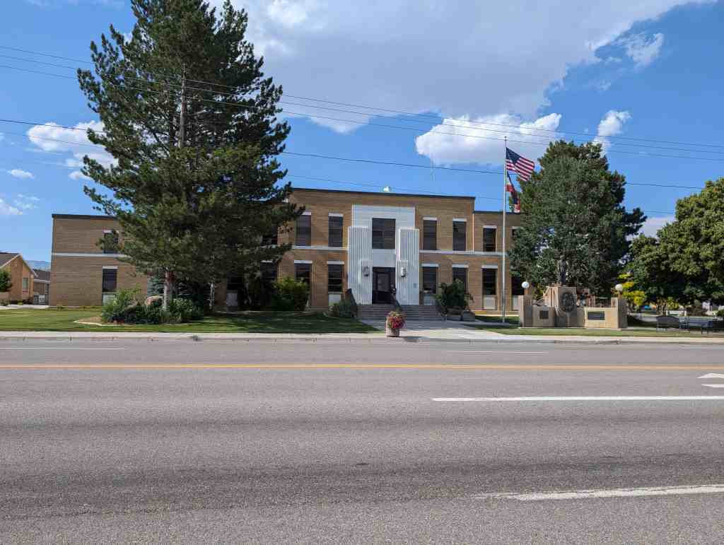
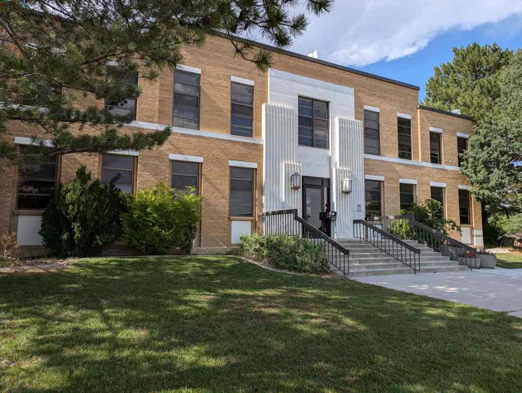
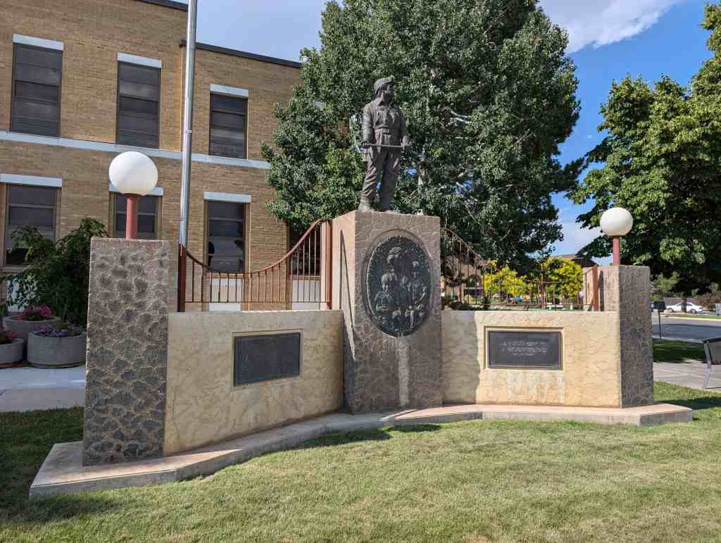
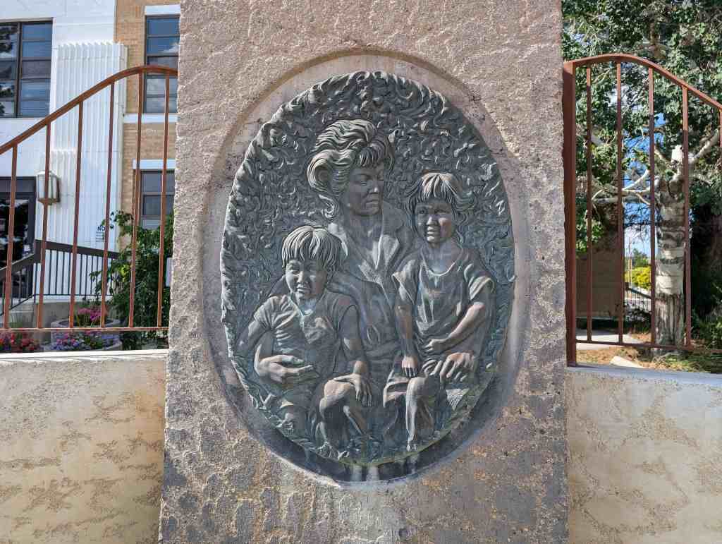
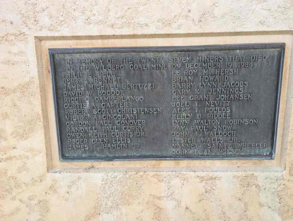
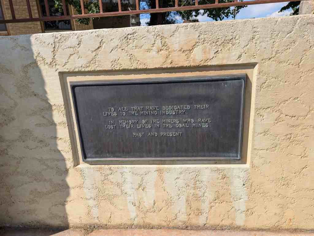
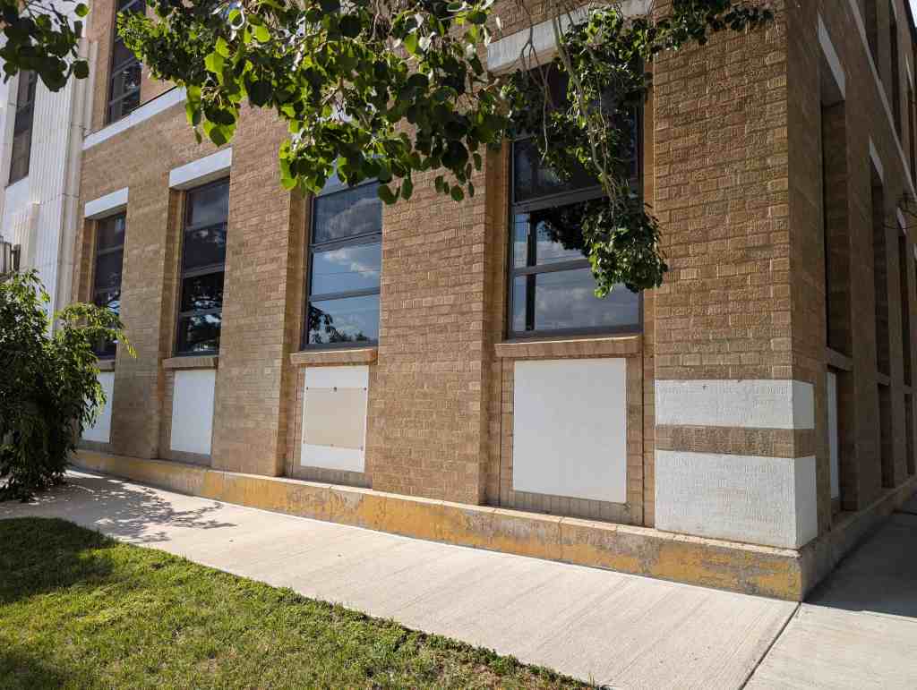
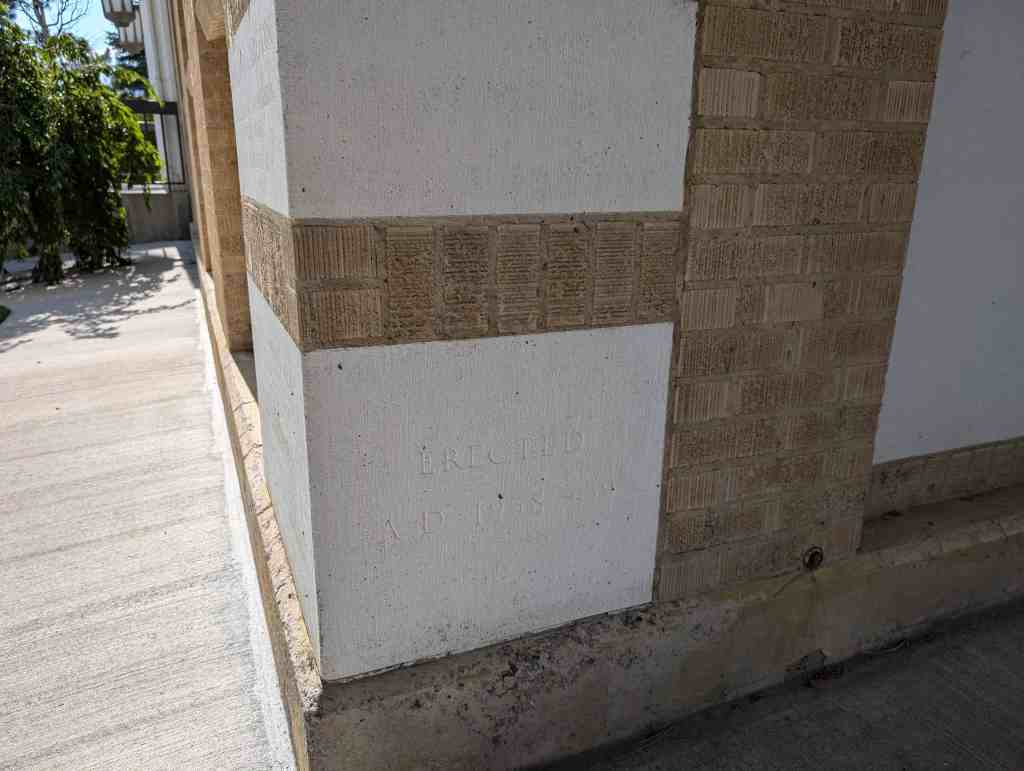
Emery County Court House built in 1938-39 as one of Utah’s WPA New Deal Projects.
95 East Main Street in Castle Dale, Utah


23 Thursday Oct 2025
Posted in Uncategorized
Tags
Castle Dale, Courthouses, Emery County, New Deal Funded, utah, WPA
Emery County Court House built in 1938-39 as one of Utah’s WPA New Deal Projects.
95 East Main Street in Castle Dale, Utah
09 Thursday Oct 2025
Posted in Uncategorized
Tags
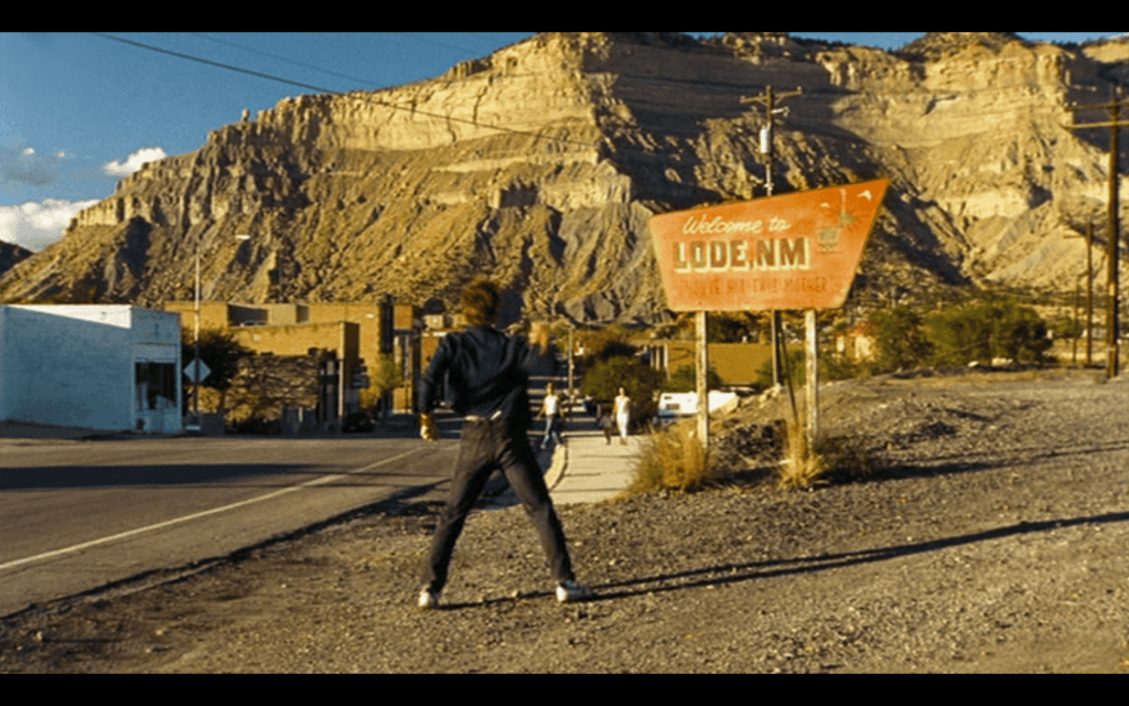

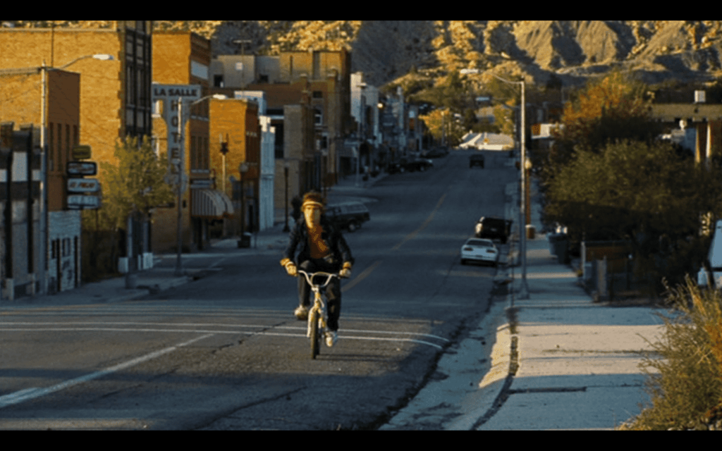
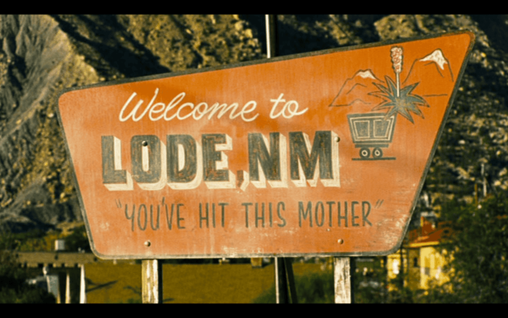
Welcome to Lode – Adventures of Power Filming Location
This is the location for multiple scenes on the movie showing the entrance to the fictional town of Lode, New Mexico from the movie Adventures of Power (2008).
It was filmed in Helper, Utah.
Related:

30 Tuesday Sep 2025
Posted in Uncategorized
Grotto Camping Ground North Comfort Station
The Grotto Camping Ground North Comfort Station is located in Zion National Park in Washington County, Utah and was added to the National Historic Register (#86003705) on February 14, 1987.
25 Thursday Sep 2025
Posted in Uncategorized
Wendover Air Force Base
Related:
The Wendover Air Force Base is located in south Wendover, Utah and was added to the National Register of Historic Places (#75001827) on July 1, 1975. The following text is from the nomination form for the historic register:
The history of the base began in 1939 when the Air Corps commenced an extensive expansion program. High on the priority list v/ere adequate bombing and gunnery ranges.
By 1940 a site was located at Wendover. The Air Corps desired some 3,000,000 acres of land 90% of which was public domain. However, because of grazing commitments, the Interior Superintendent was willing to release only 1,500,000 acres. Livestock men in the area suggested that another site be selected or the area reduced in size. They estimated that use of the 1 1/2 million acres would “wipe out 100 outfits” of livestock men and cost the state about $1,500,000 annually.
Despite these objections, work began on the base in November 1940. Temporary barracks were constructed and two 150 x 7000′ runways with taxi strips and anchorage areas were graded and graveled. In May 1941, the areas were paved and more extensive construction began.
The first training unit arrived at Wendover April 6, 1942 and found the area ideal for bombing and gunnery practice. Because of the abundance of salt, obtainable from the nearby Bonneville Salt Flats, a city of salt was constructed near the mountains for bombing practice.
The historical significance of the base is its role as the training site for the 509th Group under the command of Colonel Paul W. Tibbets, Jr. It was Colonel Tibbets, flying his B-29, “The Enola Gay,” who dropped the atomic bombs on Hiroshima and Nagasaki in August 1945.
The 509th Group was organized December 17, 1944 and trained at Wendover until May of 1945 when it left for Tenian Island in the Marianas. During its stay at Wendover, the group was housed in a maximum security area. Information about the group’s mission was so restricted that even members of the 509th did not know the purpose of this training.
Although the bombing of Hiroshima and Nagasaki has been regarded by some people as a means too terrible even for use in world wide conflict, it did bring to an end the war with Japan. The crew of the u Enola Gay’ proved that an atomic bomb could be used under combat conditions. The threat of its future use served the United States as an important post war foreign policy tool. For its role in ushering in the Atomic Age, the Wendover Air Force Base deserves recognition.
Wendover Air Force Base is located just south of the town of Handover, Although presently unoccupied the base chapel, hospital, barracks, administration offices, hangars, and other buildings remain.
The fire station is still in use by the base caretakers–the base was closed by the Air Force in 1963. One runway is still in use for commercial and private air traffic into Wendover. The Air Central building serves as headquarters for this limited use of the base.
The barricaded area, where the crew of the Enola Gay was housed, remains on the south side of the base separated from the other buildings by the runways.
The buildings which do remain were built in the typical World war II temporary military use style. They are frame buildings and, since 1963, have deteriorated from lack of use.
At present the state of Utah is attempting to acquire the air base site. Several businesses have expressed an interest in using the air base buildings for offices and warehouses. The runway will continue to serve as Wendover’s airport.
21 Sunday Sep 2025
Posted in Uncategorized
Tags
Howe Flume Historic District
The Howe Flume Historic District was added to the National Register of Historic Places (#78002695) on December 12, 1978.
Related:
18 Thursday Sep 2025
Posted in Uncategorized
Tags
Lincoln Highway Bridge
During the early days of Tooele County area around 1900 a road was constructed over Johnson Pass and on west across what is now Dugway Proving Ground. The Goodyear Tire and Rubber Co. was interested in opening a road to the west which became the Lincoln Highway. Mr. Fisher was president of the company and invested a large amount of money in the project. A group of convicts from Utah State Prison were camped at Clover Creek in order to start the construction, and later moved west as the road progressed. Their work included the construction of subject bridge and tiie building up of the elevated causeway from Granite Peak to the west edge of the salt flats. The portion of the road from Johnson Pass to west edge of the salt flats was known as the Goodyear Cut-off in honor of the interest and money the company invested. Attempts to make this road the main route to the west coast were not successful as certain influential persons in Salt Lake City wanted the western route to pass through that city. Therefore the Lincoln Highway passing through Dugway Proving Ground was abandoned in the early 1920’s, and was used by local ranchers and mining interests. This bridge is an existing structure of the original national Lincoln Highway from Lincoln, Nebraska to Sacramento, California. It is the only significant structure in this area that remains of the original proposed national highway.
The Lincoln Highway Bridge was added to the National Register of Historic Places (#75001825) on May 21, 1975 and is located in the Ditto area of Dugway, Utah.
Related:
The bridge is of hewn logs and log supports. Hewn logs make up deck of bridge and circular logs make up supporting members. Abutments are of rock construction with concrete added in early 1930’s by CCC Camp to support badly deteriorated rock abutments. Dimensions are.14V-6″ long by ll’-6″ wide. Rails along the sides of the bridge have fallen “off. It is estimated that the structure was built about 1900, with rehabilitation by CCC Camp at Clover Creek in the early 1930’s. A new road and bridge diverted traffic away from bridge; consequently, it has remained in fairly good condition.
16 Tuesday Sep 2025
Posted in Uncategorized
Tags
Thompson Family Farmstead
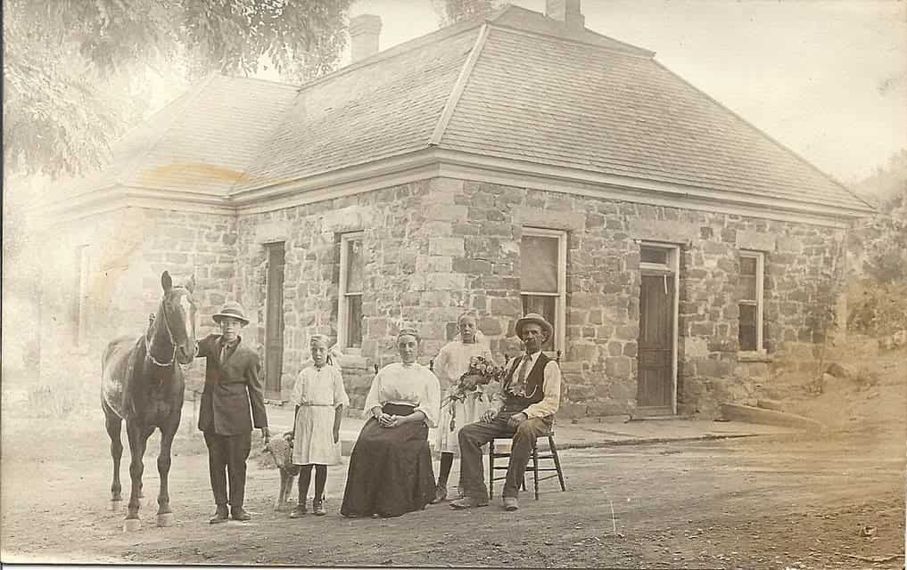
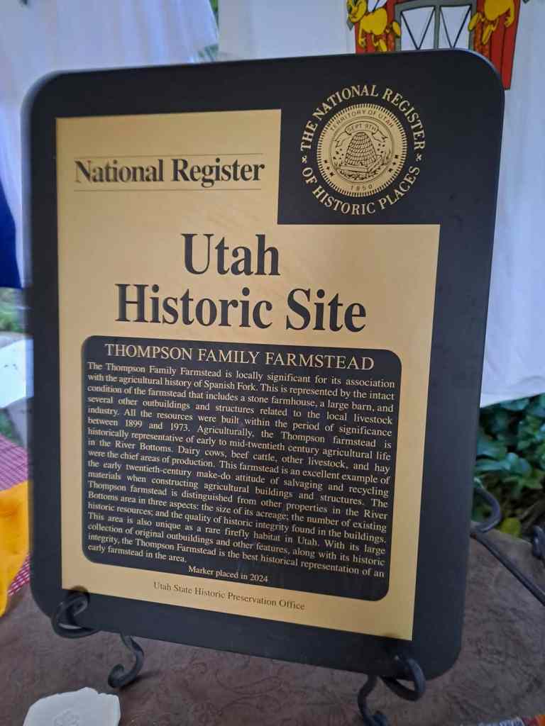
The Thompson Family Farmstead is locally significant for its association with the agricultural history of Spanish Fork. This is represented by the intact condition of the farmstead that includes a stone farmhouse, a large barn, and several other outbuildings and structures related to the local livestock industry. All the resources were built within the period of significance between 1899 and 1973. Agriculturally, the Thompson farmstead is historically representative of early to mid-twentieth century agricultural life in the River Bottoms. Dairy cows, beef cattle, other livestock, and hay were the chief areas of production. This farmstead is an excellent example of the early twentieth-century make-do attitude of salvaging and recycling materials when constructing agricultural buildings and structures. The Thompson farmstead is distinguished from other properties in the River Bottoms area in three aspects: the size of its acreage; the number of existing historic resources; and the quality of historic integrity found in the buildings. This area is also unique as a rare firefly habitat in Utah. With its large collection of original outbuildings and other features, along with its historic integrity, the Thompson Farmstead is the best historical representation of an early farmstead in the area.
7421 South River Bottoms Rd in Spanish Fork, Utah
07 Sunday Sep 2025
Posted in Uncategorized
Tags
Historic Districts, Millcreek, Mountair Acres Subdivision Historic District, NRHP, Salt Lake County, utah
Mountair Acres Subdivision Historic District
The Mountair Acres Subdivision Historic District (hereafter referred to as Mountair Acres) is one of Millcreek’s earliest subdivisions, composed of approximately 75 acres along Highland Drive, a major commercial corridor between Salt Lake City and Millcreek. While the neighborhood started as a rural area, it was acquired and mined for its high natural clay content by the Salt Lake Pressed Brick Co. The subdivision was first platted in 1939 with construction starting in 1940. Several model homes were available for viewing, including a collaboration with Montgomery Ward. Over the next nine years, the subdivision was platted and construction completed in 1952 with all lots built and sold. Design of Mountair Acres added the flair of a curved street, Crescent Drive, as a key focal and circulation point that set it apart from traditional grid subdivisions. Use within Mountair Acres is completely single-family residential. Character-defining features of the district include uniform setbacks, landscaping with mature trees in the park strip, grass lawns, rear garages, and one story buildings. There are a total of 709 resources in the Mountair Acres Subdivision Historic District with three architectural styles within the period of significance (1940-1959). Contributing buildings number 523 (74%), while there are 186 (26%) non-contributing resources, including one (<1%) non-contributing site. The 709 resources break down to 374 (53%) primary resources and 334 (47%) secondary resources. Within the category of primary buildings, the integrity numbers remain strong with 307 (82%) contributing and 67 (18%) non-contributing. Despite limited square footage and location near Salt Lake City, the neighborhood has not been a target for teardowns for larger houses to the present date which has led to a high degree of retained integrity in all seven areas.
The text on this page is from the nomination form for the national historic register.
The Mountair Acres Subdivision Historic District is located in the city of Millcreek, Salt Lake County, Utah. Millcreek is a suburb located immediately south of Salt Lake City. Topographically, Millcreek consistently rises in elevation west to east, from the valley floor, to the east bench, and into the foothills. The city is named for the Mill Creek, which runs east-west and is located south of Mountair Acres approximately one-half mile.
Following the general topography of the community, the original topography of the Mountair Acres subdivision site was slightly sloped rising west to east. It’s ownership and use by the Salt Lake Pressed Brick Company excavated several feet of natural clay deposits from the site, lowering the overall topography and creating a man-made shelf on the eastern boundary of the neighborhood. However, the 75 acres that comprise Mountair Acres today is flat in topography.
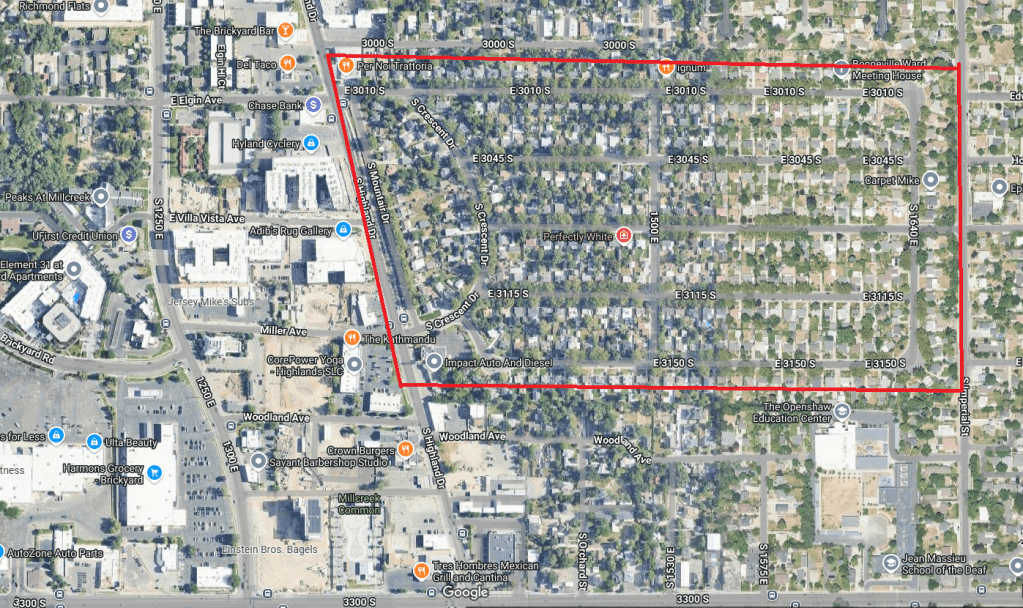
The neighborhood was platted with a layout of streets that broke from the earlier typical cardinal grid pattern of Salt Lake City, known as the Plat of the City of Zion. The west boundary of the subdivision aligns with Highland Drive, one of the few early diagonal roads in the valley.1 A linear park that runs parallel to Highland Drive separates the subdivision from the road traffic. Originally, a row of bushes was planted within the park area and grew over 10 feet high, serving as a landscape buffer. Mountair Drive runs parallel to Highland Drive and the park. Behind Mountair Drive is Crescent Drive which is aptly named as it curves north to south. Each of the five east-west streets intersects with Crescent Drive as it serves as the connecting point for the subdivision on the west. On the east, 1640 East is the connecting point with all east-west streets intersecting. In the center of the subdivision, 1500 East serves as a circulation street that runs north-south to break up the east-west blocks. No alleys exist with driveway access coming directly from the street to the side of each house. There are three entry/exit points to the subdivision: Gregson Avenue on the east leading to Imperial Avenue (1700 East), and 3010 South and Crescent Drive on the west leading to Highland Drive.
Development of the Mountair Acres Subdivision was spread out over 12 years and seven separate plats with the majority of construction occurring in 1948 when 126 houses were built. One additional house – 3004 S. Imperial Street – was constructed in 1959 but is located at the edge of the subdivision and is the only resource on Imperial Street. While the first year of subdivision development resulted in 13 houses constructed, there were seven subsequent years when at least 20 houses were built within a year.
Architectural Styles, Building Types, and Materials
In Mountair Acres, the subdivision’s consistent appearance and visual character stems not only from the mature trees that line its streets, but also the use of similar architectural style. Many of the buildings exhibit characteristics of Ranch style buildings, but were not designed as Ranch or Early Ranch buildings; therefore, being categorized as Minimal Traditional in style. A single resource, categorized as Other, is a park.
Minimal Traditional
The Minimal Traditional-style residences, as the name suggests, exhibit an overall simplicity of form and architectural detail, lending these characteristically small houses the appearance of maximum size. McAlester details the style’s additional features to include a “Low- or intermediate-pitched roof, more often gabled; small house, generally one-story in height; roof eaves usually have little or no overhang; double-hung windows, typically multi-pane or 1/1; minimal amounts of added architectural detail; rarely has dormers.” There are 66 examples of the Minimal Traditional style with a range of construction dates between 1940-1952. Fifty-three (80%) of the examples are contributing while 13 (20%) are non-contributing. Examples of the Minimal Traditional style include 1602 East 3115 South and 1387 East 3010 South.
Ranch
The identifying features of the Ranch style according to McAlester include a “Broad one-story shape; usually built low to ground; low-pitched roof without dormers; commonly with moderateto-wide roof overhang; front entry usually located off-center and sheltered under main roof of house; garage typically attached to main façade (faces front, side, or rear); a large picture window generally present; asymmetrical façade.” In the district, there are 308 examples of the Ranch style, including the Early Ranch. Their dates of construction are between 1940-1959. Contributing resources number 253 (82%) examples of the style and non-contributing examples number 54 (18%). Examples of the Early Ranch style include 1625 East 3150 South, 1626 East 3010 South, 3021 S. Mountair Dr., 1424 East 3115 South, 1495 East 3010 South, 1414 East 3010 South, and 1368 East 3010 South.
The single example of the Ranch style rambler is located at 3004 S. Imperial St. and was constructed in 1959. The term rambler is often used interchangeably with the Ranch style, but can denote a derivation featuring an attached garage and elongated façade.
Materials
Much like the architectural styles and building height within Mountair Acres, the construction materials are also overwhelmingly consistent, with brick being the main construction material for 93% (348) of the primary buildings. Veneers compose 21 of the buildings (5%) and there are five wood buildings. (2%).The one Other/Undefined resource is the park.
Common Characteristics and Variations
The houses are roughly the same size, 600-800 square feet on the main level, lending to the visual cohesion of the neighborhood. This size was based on the Federal Housing Administration (FHA) “minimum house” standards developed in the mid-1930s as part of the National Housing Act. The standards also made recommendations for floor plans and stylistic elements. Two years later, new recommendations were added to the standards for construction quality and equipment.
The three styles share common features. Because no original floor plans exist, the primary buildings are compared by their exterior appearances. This includes bay windows, circular windows, corner (or meeting) windows, and picture windows. There are many more asymmetrical forms (331; 89%) than symmetrical (43; 11%). Another method to compare variations is through roof types. Roof types vary greatly from side gable examples and side gable variations (225; 60%) and hipped examples and hipped variations (147; 39%), cross gabled forms (2; 1%).
The roof type or form alone do not distinguish the style as common characteristics were blended between all styles and forms. The evidence of these common characteristics demonstrates how the transition of styles led to blending of ideas. In dozens of examples, multiple features such as these were also utilized together. For example, the house at 3009 S 1640 E is an example with a bay window and circular window with a hipped roof. At 1517 East 3045 South is a house the is symmetrical with two corner (meeting) windows and center door on the main façade with a hipped roof. An example with a bay window and picture window under a side gabled roof is located at 1449 East 3010 South. The unique combination of a circular window, picture window, and corner (meeting) window are included on the house at 1517 East 3010 South.
Variations of styles begin with roof forms and symmetry. Using these as a basis of the design, various arrangements of window openings were applied in over a dozen different arrangements. Some of these may have been based on floor plan while others on personal choice and budget. Symmetrical variations include the side gable version at 3079 S. Mountair Dr. and hipped roof version at 1517 East 3045 South. Asymmetrical variations include the side gable version at 3025 S. Crescent Dr. and the hipped roof version at 3023 South 1640 East. There are a few limited variations that have more complex roof forms including the intersecting hipped roof with front gable accents and attached garage at 3046 S. Crescent Dr., the multiple intersecting hipped roofs of the house at 1415 East 3010 South, and the complex roof form at 1495 East 3010 South.
Outbuildings
There are a total of 364 secondary buildings (outbuildings) within the historic district boundary. Unattached one bay garages are the most numerous at 196 (59%) followed by unattached two bay garages 117 (32%), there are 20 sheds (5%), and one unattached carport (1%). Examples of sheds include 1524 East 3045 South, 1559 East 3010 South, 3026 S. Crescent Dr., and 1424 East 3045 South. Out of the 334 total outbuildings, 216 are contributing to the historic district: unattached one bay garages number 157, unattached two bay garages number 53, and six contributing sheds. Material variations within the single bay are attached, unattached brick, unattached wood, unattached with shed, and unattached with half story above. Material variations within the double bay are brick, concrete block, and wood. Examples of variations within the single bay category include 1443 East 3010 South (wood;, 1560 East 3010 South (brick; Photo 28), 1631 E. Gregson Ave. (stucco;, 1571 East 3010 South (flat roof;, 1639 East 3010 South (with shed;, and 1566 East 3010 South (with carport;. Examples of variations within the double bay category include 3052 South 1640 East (brick;), 1547 East 3150 South (concrete block; Photo 34), and 1583 East 3045 South (half story above;. The single unattached carport is located at 1489 East 3115 South. Examples of flat-roof carports are found at 1526 E. Gregson Ave. and 1524 S. Gregson Ave. Angled carports are located at 3040 S. Crescent Dr. and 3059 South 1640 East.
Change over Time and Historic Integrity
The Mountair Acres Subdivision Historic District retains a high degree of the seven aspects of integrity as detailed by the following:
There were no vacant lots left from the time of the subdivision’s original platting and none exist currently. The block divisions, parcel sizes, and original construction on each lot has remained intact for the majority of properties. Zero intrusions exist as there have not been any teardowns and new construction. Only one house has made an incompatible addition to the top of an original one-story building. Additions, when constructed, have commonly happened behind the house. The majority of garages date to the historic period. New (out of period) garages have typically been placed in the same rear corner lot position as garages have been historically located and remained one story in height. The original park between Mountair Drive and Highland Drive was redesigned and renovated in 2020 with new landscaping and a sidewalk.
Five houses retain one or more original windows. These are located at 1494 East 3045 South, 1505
East 3045 South, 1420 East 3150 South, 1482 East 3150 South, and 1536 East 3150 South.
Location
The aspect of location integrity is intact as the neighborhood remains built in its original location and no buildings have been moved in or out of Mountair Acres. The boundary for Mountair Acres follows the boundaries of the seven original subdivision plats between 1939 and 1948. The streets remain in their original design and lot sizes have remained constant with none being combined or subdivided further.
Design
The overall design of the Mountair Acres Subdivision’s streets, blocks, lots, and yards hold integrity with very few changes since the original platting and construction. Throughout the entire neighborhood, original sidewalks and front yards remain intact. Garages are located at the rear of each property and accessed by long driveways from the street. Except in a few cases when the garage is located on the street for a corner property. Trees in the front yards on every street have matured for several decades creating a natural canopy for the neighborhood. Modest front yards between the sidewalk and the buildings have been maintained and remain contiguous, typically not separated by fences, giving a consistent look along the streetscape.
The design of individual buildings is a narrow representation of styles that were becoming popular nationally at the outset of World War II.
Despite the Salt Lake City area being a strong real estate market over the last 25 years, the neighborhood has resisted the teardown epidemic that other neighborhoods have had to face. However, alterations to individual residences have been frequent in the last 50 years. The most frequent changes have been exterior alterations such as window, roof, and sheathing replacements. Several buildings exhibit additions. While the majority of additions to historic buildings in the district are located at the rear and thus are compatible with both original construction and the context of the neighborhood as a whole, a few non-contributing examples are notable for their poor design and/or location on the building.
Setting
Surrounding Mountair Acres are distinctive neighborhoods of their own. To the west is the Highland Drive commercial district. To the north and south are neighborhoods of later construction dates and varied integrity. To the east is a neighborhood of mixed construction date, between 1920 and 2024, with varied integrity and less distinctive architectural consistency.
Within the physical environment of Mountair Acres, however, is strong integrity of the original buildings as well as the developed setting around the buildings. The original sidewalks remain intact in their original locations and at their original sizes. Trees, front yards, and other vegetation have matured for several decades, creating the garden-like natural environment within the neighborhoods. Few chain link fences are present in front yards.
Materials
The dominant building material within Mountair Acres is brick, utilized for both structure and exterior material. This is a dominant characteristic of contributing buildings and thus retain their integrity in this aspect. These materials have deeper significance as they were created by the Salt Lake Pressed Brick Company from some of the same clay on which the subdivision sits. Other construction materials include wood (structural framing and sheathing). If changes have occurred, most often that was in the form of new windows in aluminum or vinyl materials. While many wood buildings retain their original sheathing, many have been covered with aluminum or vinyl siding. Occasionally, a roof was replaced with new materials that were not historic, such as metal (aluma-lock) or rubber shingles replacing asphalt shingles. Dozens of houses have added a small porch over the original stoop, but in most cases do not detract from the historic appearance or create permanent alterations.
Workmanship
Mountair Acres is unique in Salt Lake County as an example of a neighborhood built over a relatively short period of time with a narrow array of architectural styles that has retained its overall historic character. The workmanship invested in the craftsmanship of the buildings within Mountair Acres remains evident in the styles, forms, and details, even when some materials may have changed.
Feeling
Mountair Acres’ consistent setback and scale, consistency of historic styles, retention of historic outbuildings, and associated landscape elements all contribute to its strong integrity of feeling as an early-to-mid-twentieth century residential neighborhood.
Association
Through the retention of its historic layout, scale, architectural features, and materials, Mountair Acres clearly conveys its historic associations with the early mid-twentieth century architectural development within Salt Lake County.
30 Saturday Aug 2025
Posted in Uncategorized
Tags

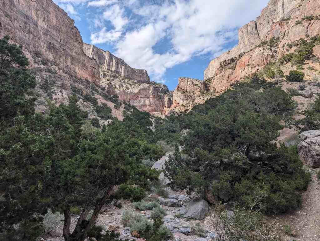
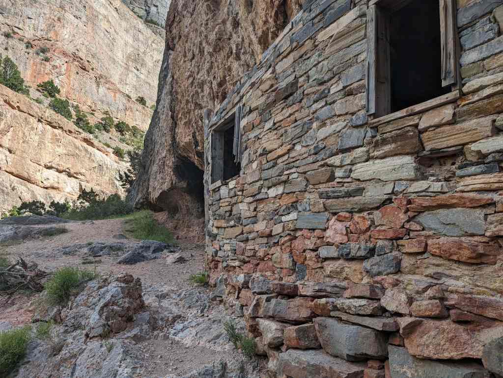
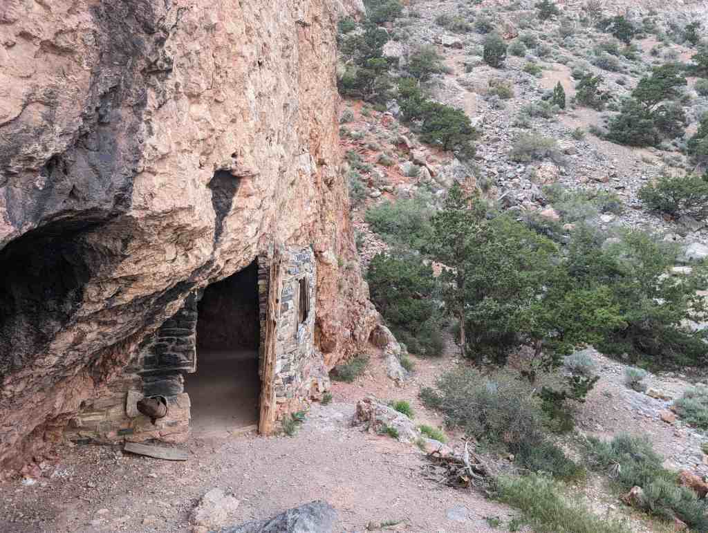
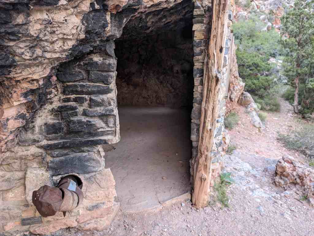
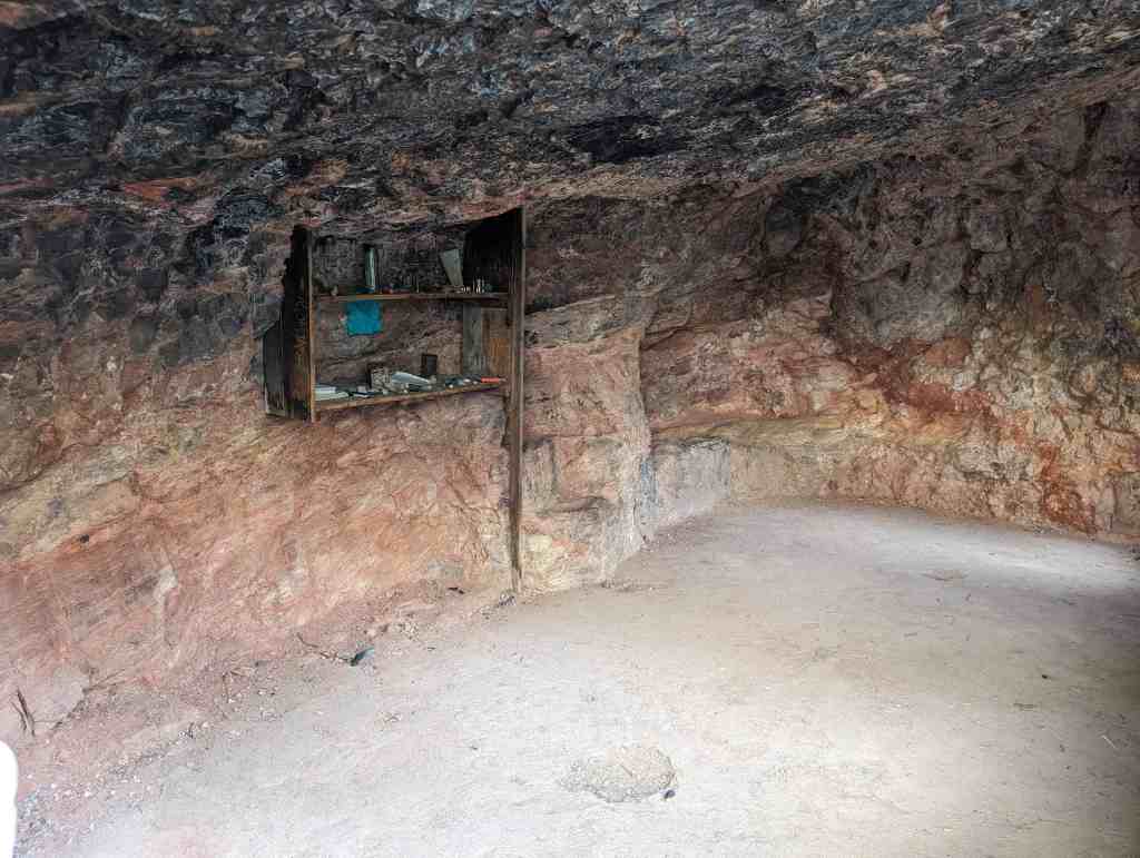
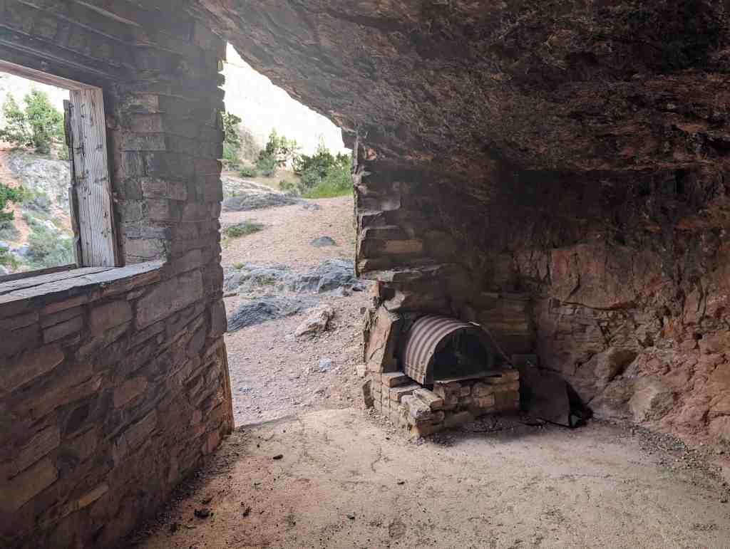
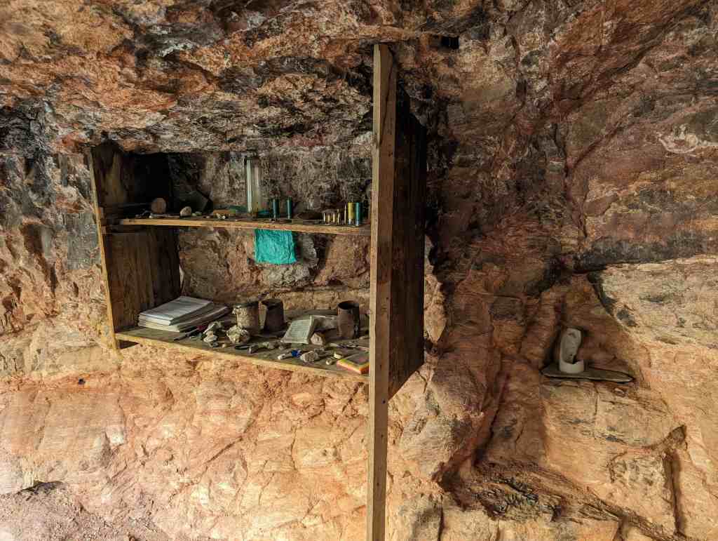
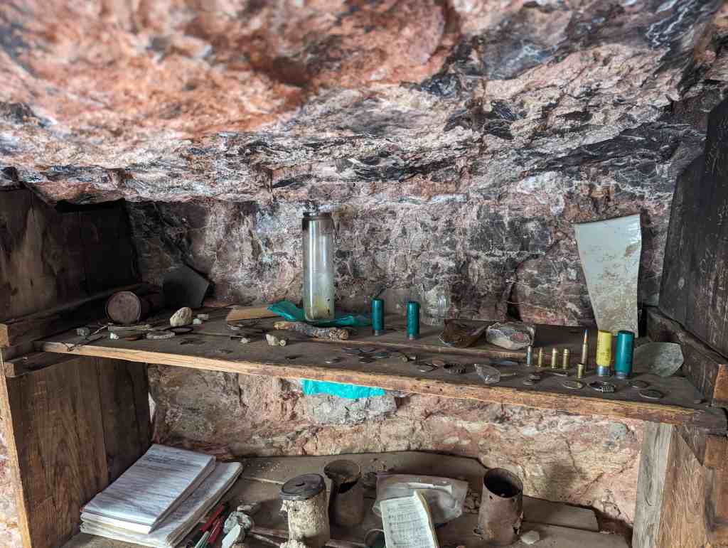
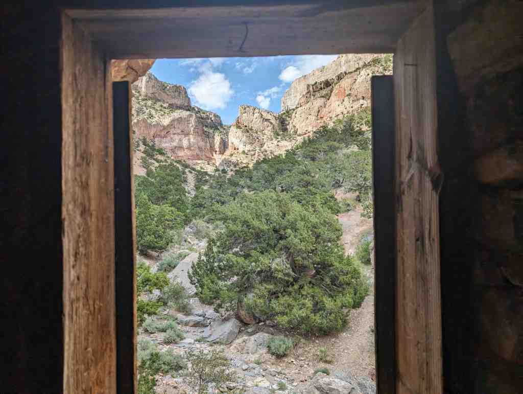
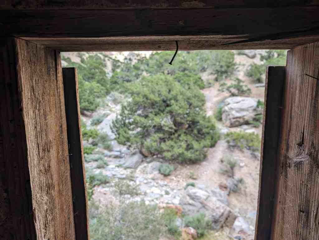
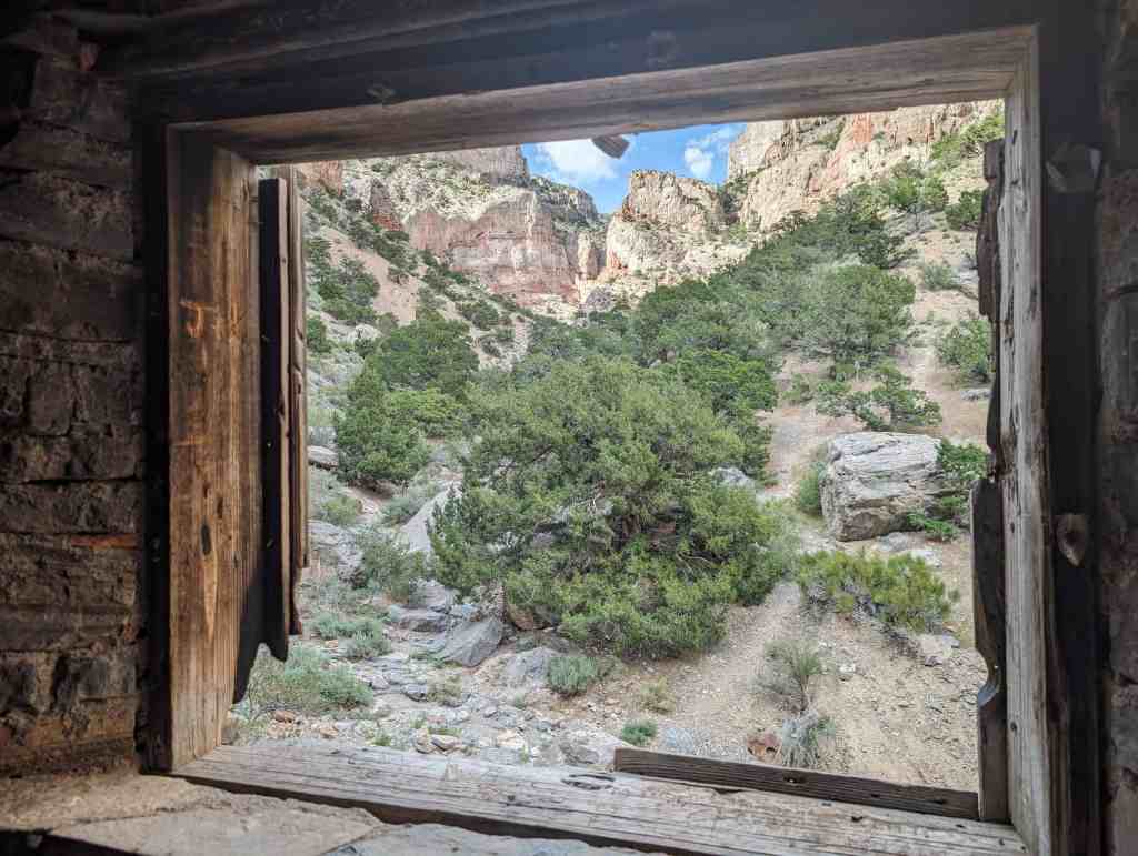
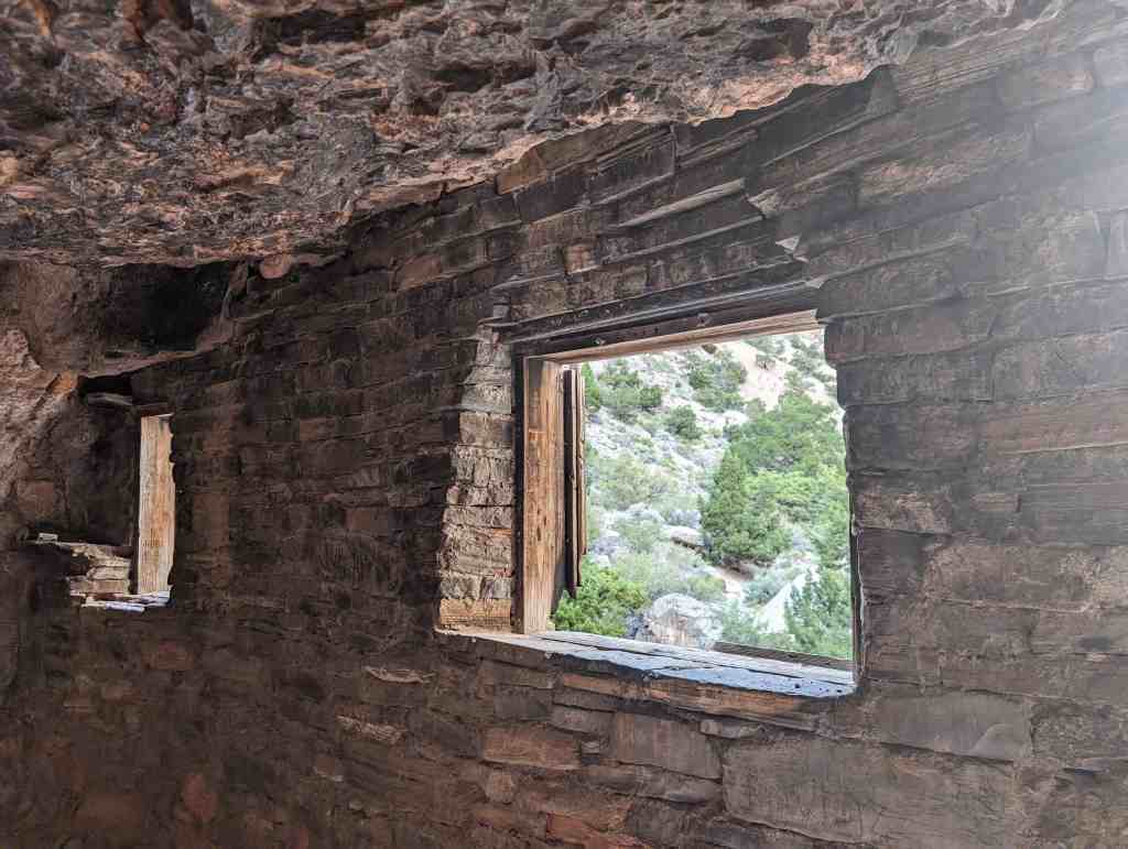
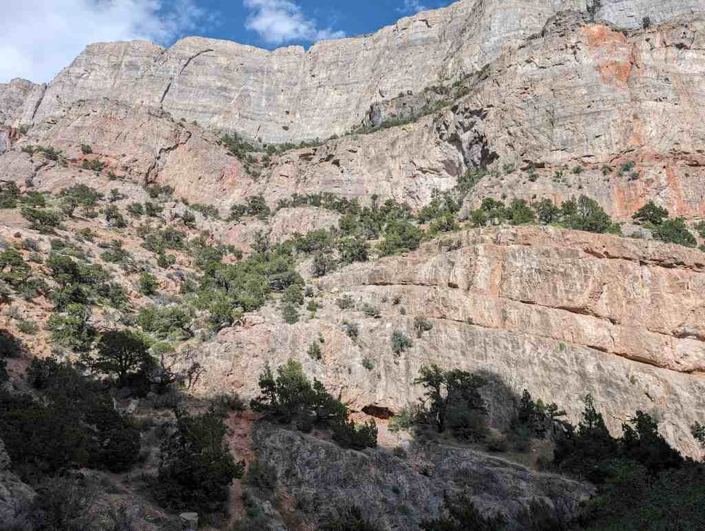
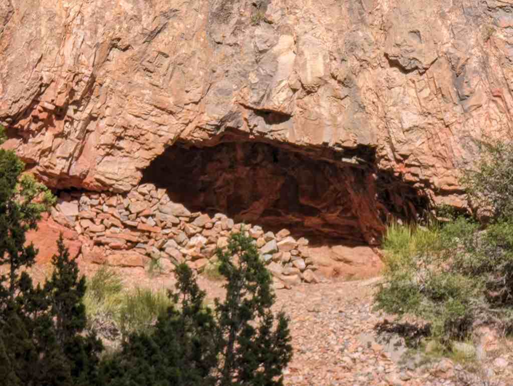
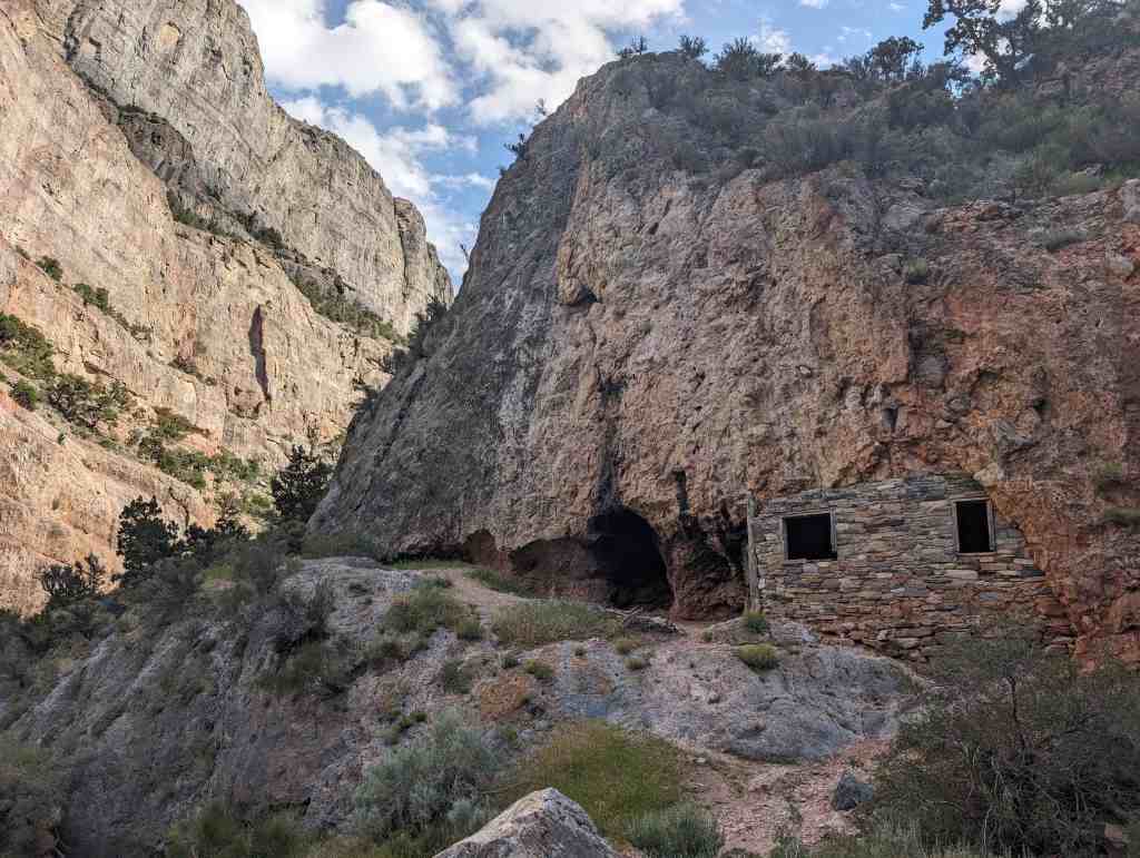
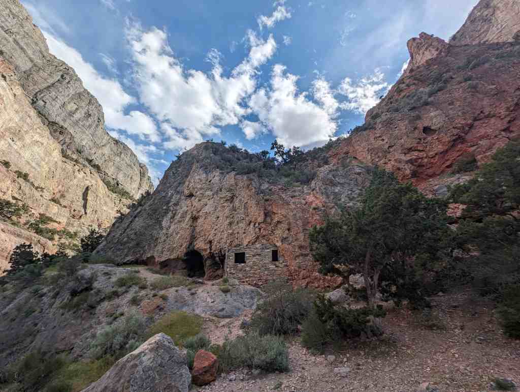
Hermit’s Cabin
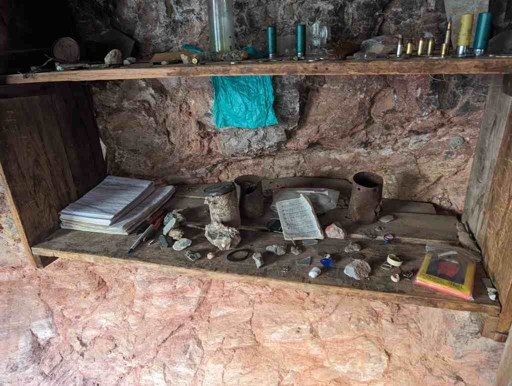
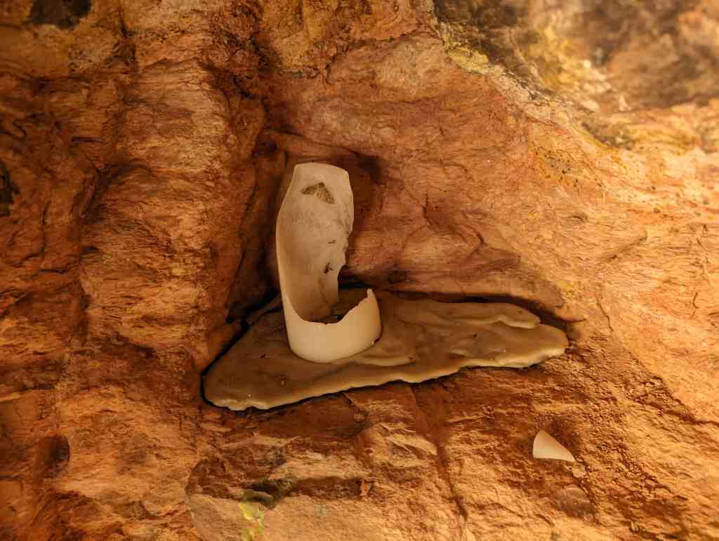
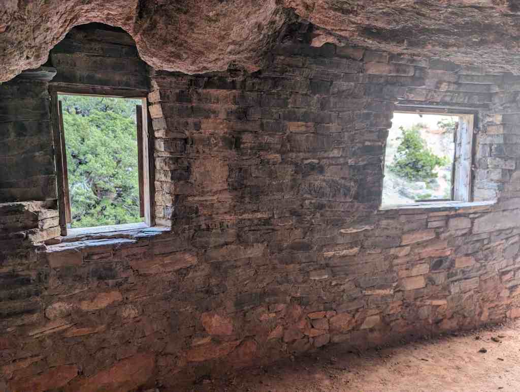
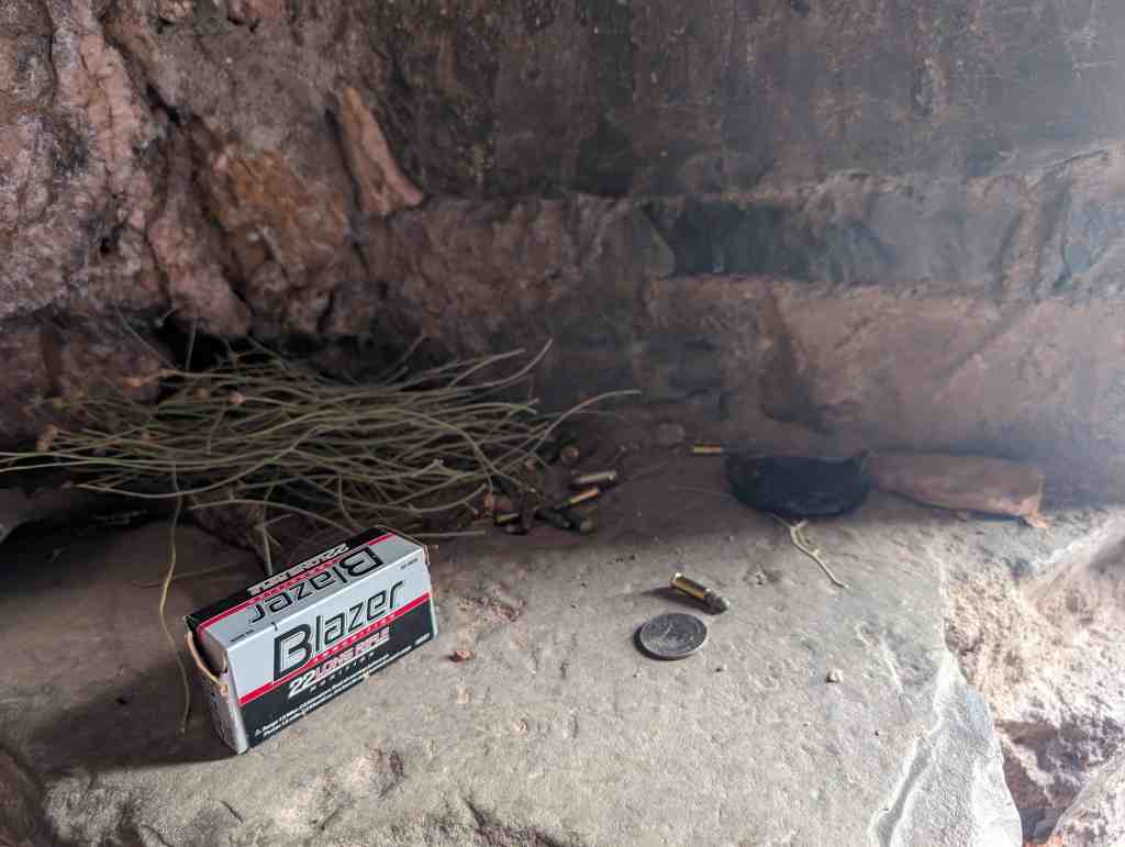
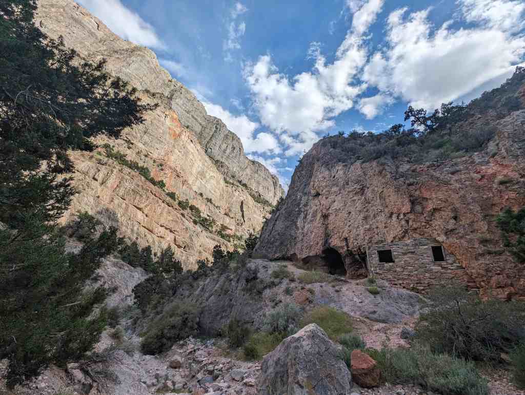
The Hermit’s Cave was constructed by a man named Bob Stinson. Bob served his country in World War I. Upon returning home from the war he learned that his girlfriend left and married another man. Heart broke he decided to travel to Delta Utah to visit his brother in 1929. While making his way through the Marjum Pass just 45 miles from Delta Utah; Bob’s house on wheels broke down. Looking for shelter Bob located a small natural cave in the side of a canyon. By using local rock, he enclosed the front of the cave which is now known as the Hermit’s Cave House, or Hermit’s Cabin. Bob was often called the Hermit of Marjum Pass. The government paid him to keep the pass clear of debris, as it was at the time the major east/west highway from Delta to Nevada. To earn extra spending money he trapped bobcats and coyotes, mixed poisons for the government to kill grasshoppers, and he even raised a handful of sheep. When Bob would have visitors, out of the greatness of his heart, he would offer them a glass of home brew. In 1951 Bob lost his road job when the new paved highway was built several miles to the south. Bob, then in his 70’s, moved into Delta to be near a few more creature comforts. At the age of 80 when Bob passed away he was cremated and his ashes were spread at the base of the rock house he built in Marjum Pass. Please protect the Hermit’s Cave for many more generations. Please don’t lean on the walls and don’t leave your mark in anyway. Always pack out your trash.*

09 Saturday Aug 2025
Posted in Uncategorized