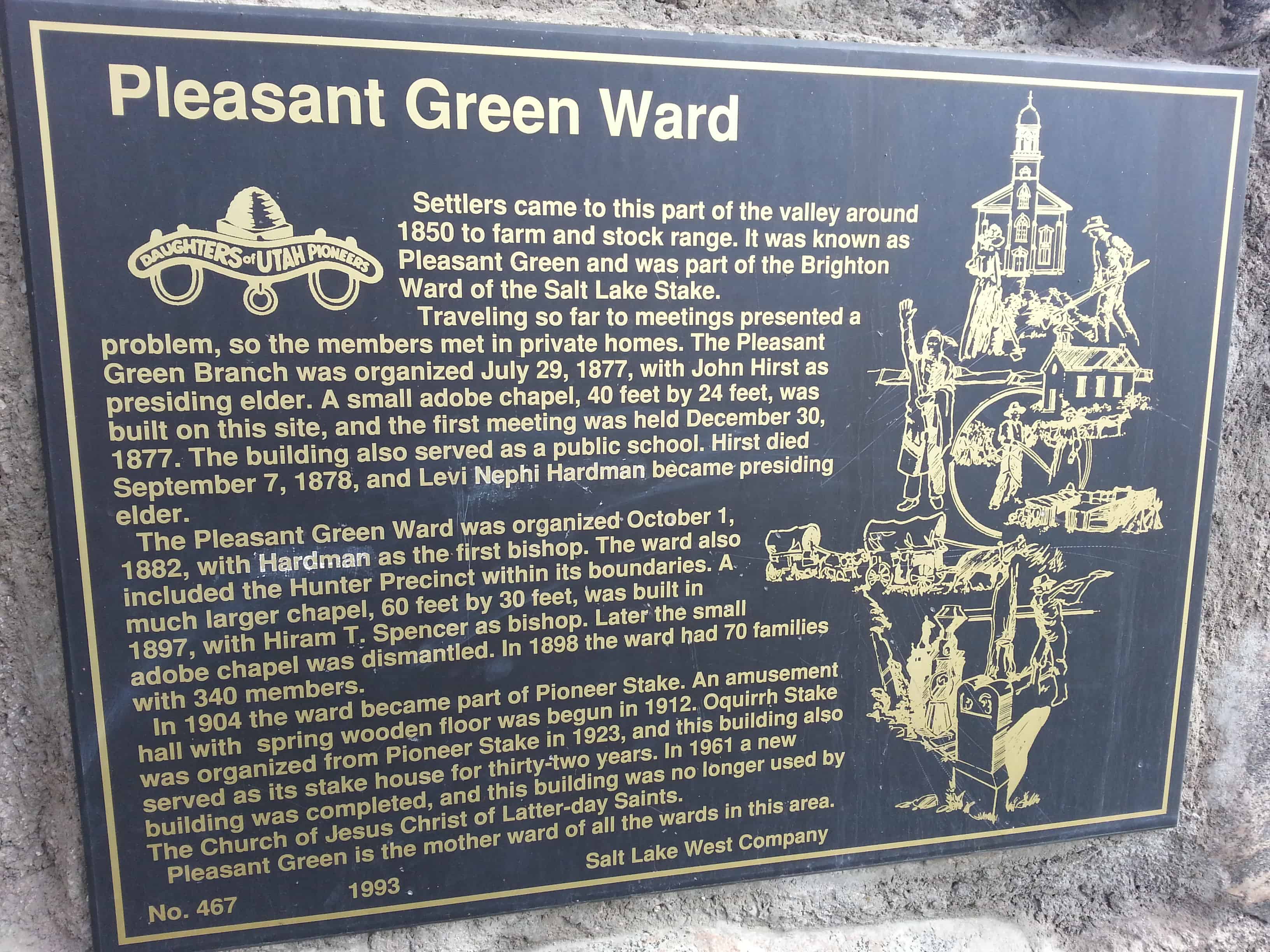
• About JacobBarlow.com
  • Cemeteries in Utah
  • D.U.P. Markers
  • Doors
  • Exploring Utah Email List
  • Geocaching
  • Historic Marker Map
  • Links
  • Movie/TV Show Filming Locations
  • Oldest in Utah
  • Other Travels
  • Photos Then and Now
  • S.U.P. Markers
  • U.P.T.L.A. Markers
  • Utah Cities and Places.
  • Utah Homes for Sale
  • Utah Treasure Hunt

JacobBarlow.com

~ Exploring with Jacob Barlow

JacobBarlow.com

Monthly Archives: June 2014

Grames Cabin

09 Monday Jun 2014

Posted by Jacob Barlow in Uncategorized

≈ 2 Comments

Tags

Carbon County, DUP, historic, Price, utah

picture16sep07-008

The Albert Grames cabin, built in 1891, stood originally on a site two miles northwest of here.  In 1904 Grames bought land in Price, dismantled his cabin, and used the logs to build this somewhat larger structure.  The cabin is unique in that it was occupied by Grames or by members of his family for seventy-four years.  He had fifteen children – fine by Celia Downard Grames and, after her death, ten by Lilly Bass Grames.  Fourteen of those children were born in this structure or its predecessor.  Seven grandchildren were also born here.

Moved to this site in 1964, the cabin was later badly vandalized.  In 1991 it was fully restored to lived-in condition.

The cabin is furnished with authentic pioneer artifacts and furniture gathered from local residents.

picture16sep07-007

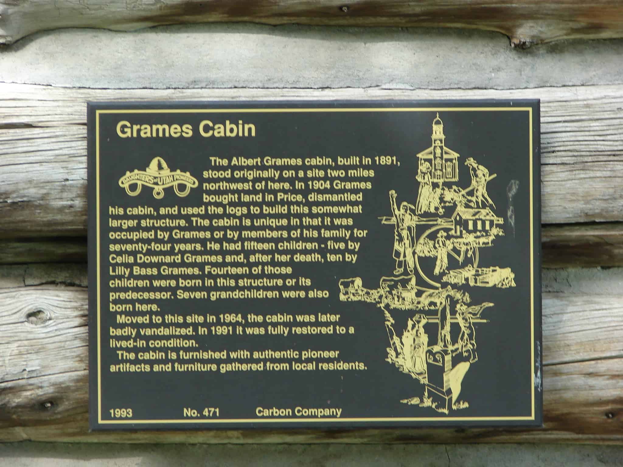
This monument is #471 of the D.U.P. Markers and is located in Pioneer Park in Price, Utah.

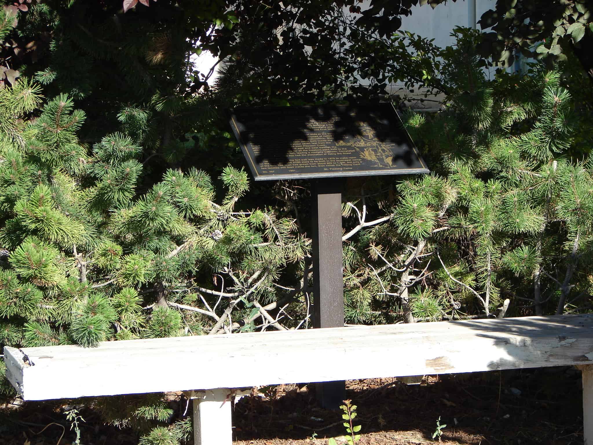
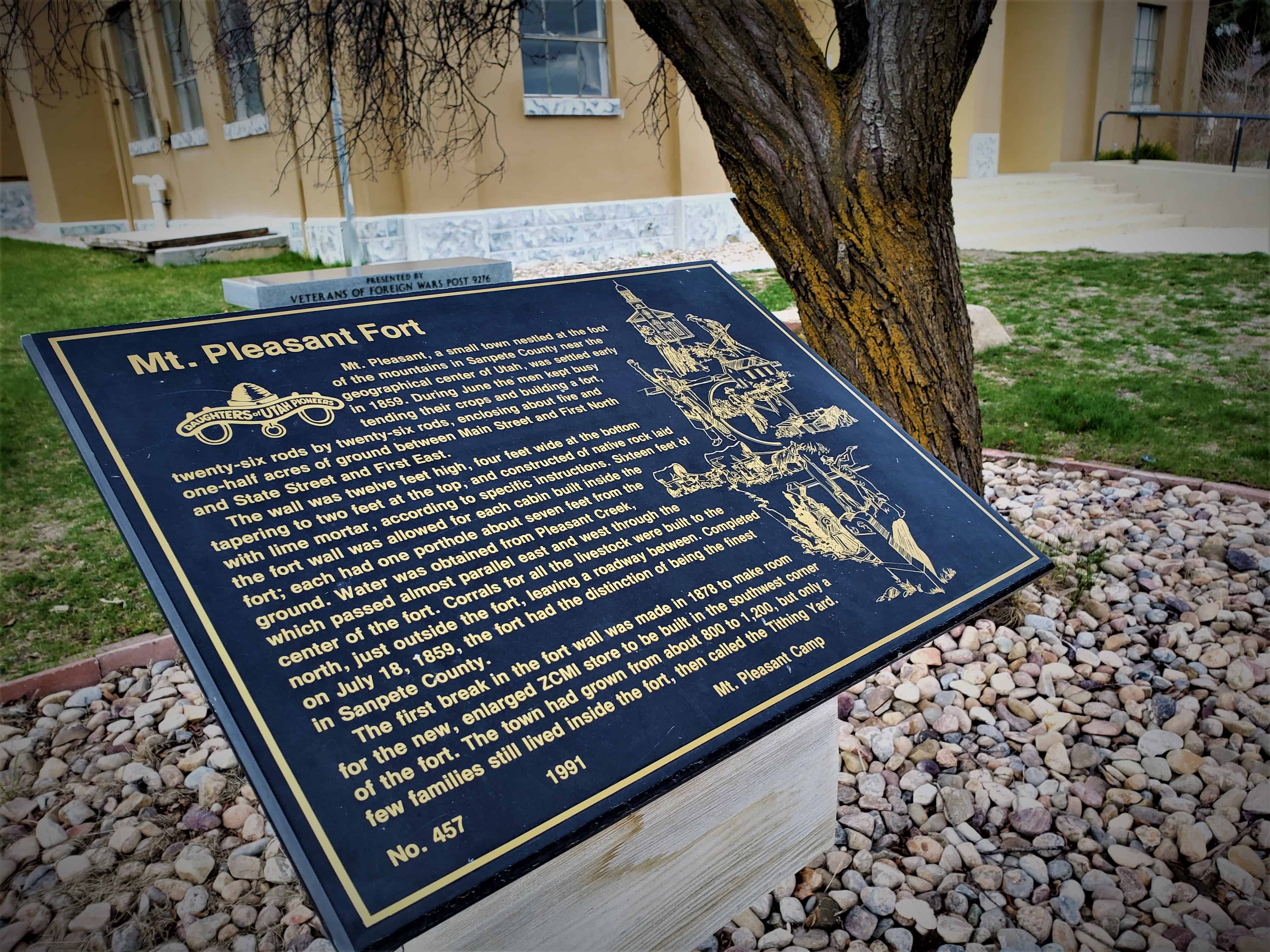
This historic marker by E Clampus Vitus is also on the same cabin:

  • Grames Cabin

Mingo Smelter

09 Monday Jun 2014

Posted by Jacob Barlow in Uncategorized

≈ 1 Comment

Tags

DUP, historic, Historic Markers, Salt Lake County, Sandy, Smelters, utah

Image

The Mingo Smelter was the largest single producer in Utah of metals such as gold, silver, and lead. When it began in 1873, it was known as the Mountain Chief Smelter and was renamed the Mingo smelter in 1876 when it was expanded. By 1881 it produced 19,000,000 pounds of unrefined metal which was shipped to Pennsylvania. The rich ores came from Little Cottonwood Canyon, Bingham Canyon and Lark and provided work for 500 to 1,200 men. Power for the smelter was provided by water traveling through a network of canals to Allsop’s Pond on the south side of Locust Street. From there, it was channeled through wooden pipes to Mingo. In 1877 the plant consisted of Blake crusher, one pair of Cornish rolls, two reverberatory furnaces for ore, matte, and flue dust, three blast furnaces, two boilers, three blowers, and one 35 horsepower horizontal engine. The iron flux came from the Tintic District, the limestone was bought in Salt Lake City, and the fuel used was coke.

Using all four of its furnaces, the Mingo Smelter could produce enough metal to fill sixteen railroad cars each week. It was destroyed by fire in 1887 and was rebuilt in 1888. The Mingo closed in April 1901 when the ores were depleted. This was one of the most successful of the old smelters that operated in Utah.

The above text is from the monument erected in 1993, located at 50 East 9000 South in Sandy, Utah

  • D.U.P. Historic Markers

Image

Pleasant Green Ward

07 Saturday Jun 2014

Posted by Jacob Barlow in Uncategorized

≈ Leave a comment

Tags

DUP, historic, Magna, Salt Lake County, utah

2013-04-09-12-00-29

Settlers came to this part of the valley around 1850 to farm and stock range. It was known as Pleasant Green and was part of the Brighton Ward of the Salt Lake Stake.

Traveling so far to meetings presented a problem, so members met in private homes. The Pleasant Green Branch was organized July 29, 1877, with John Hirst as presiding elder. A small adobe chapel, 40 feet by 24 feet, was built on this site, and the first meeting was held December 30, 1877. The building also served as a public school. Hirst died September 7, 1878, and Levi Nephi Hardman became presiding elder.

The Pleasant Green Ward was organized October 1, 1882, with Hardman as the first bishop. The ward also included the Hunter Precinct within its boundaries. A much larger chapel, 60 feet by 30 feet, was built in 1897, with Hiram T. Spencer as bishop. Later the small adobe chapel was dismantled. In 1898 the ward had 70 families with 340 members.

In 1904 the ward became part of Pioneer Stake. An amusement hall with spring wooden floor was begun in 1912. Oquirrh Stake was organized from Pioneer Stake in 1923, and this building also served as its stake house for thirty-two years. In 1961 a new building was completed, and this building was no longer used by The Church of Jesus Christ of Latter-day Saints.

This historic marker is #467 of those erected by the Daughters of Utah Pioneers, erected in 1993 at 8673 West 2700 South in Magna, Utah.

  • D.U.P. Historic Markers
2013-04-09-12-00-18

Harrisburg

07 Saturday Jun 2014

Posted by Jacob Barlow in Uncategorized

≈ 1 Comment

Tags

DUP, Harrisburg, historic, utah, Washington County

2017-03-19 16.02.02

The town of Harrisburg was founded by Moses Harris in 1859. By 1868, twenty-five families had made their homes in this little valley along Quail Creek, located three miles south of Leeds and twelve miles northeast of St. George. The town thrived almost fifty years and included some thirty homes surrounded by vineyards and orchards. Cane for sorghum and molasses was raised by bringing water from Quail Creek. Wagon freighters, plodding from Salt Lake to St. George, made Harrisburg a favorite stopping place.

When spring water diminished, or the once rushing water was diverted to other communities, many of the families were unable to continue farming and moved to other locations. They left behind a newly built dam along with the orchards and vineyards. Water, or the lack of it, spelled the fate of this community. Harrisburg has also suffered much destruction by grasshoppers in 1869.

The ruins of Harrisburg show evidence of homes, including two stone houses without roofs, and a little cemetery surrounded by a wrought iron fence. By 1928 there were only two families still living in the once thriving town of Harrisburg.

2017-03-19 16.01.50
2017-03-19 16.02.31

ImageImage

Check out all of the historic markers placed by the Daughters of Utah Pioneers at JacobBarlow.com/dup

Anderson Tower

07 Saturday Jun 2014

Posted by Jacob Barlow in Uncategorized

≈ 1 Comment

Tags

DUP, historic, Salt Lake City, Salt Lake County, SUP, utah

picture7sep07-134

Plaque A: ANDERSON TOWER…Photograph 1884 1932 SUP Site #53

Plaque B: ANDERSON TOWER DUP#463

Anderson Tower was built in 1884 by Robert R. Anderson (1848-1935), a pioneer of 1867 and one of the original settlers on the north bench of Salt Lake City. The tower was patterned after similar towers Mr. Anderson had seen in Scotland as a young boy. They were known as “follies.” It was constructed of gray granite from the same quarry used to supply the granite for the Salt Lake Temple. The circular three-story structure, located at 303 A Street, was 54 feet high and 25 feet in diameter. Inside the austere tower was a winding stairway that led past numerous windows to the observation deck equipped with a telescope.

People were charged a small fee to climb to the top for the view. The venture was unsuccessful, and Anderson opened the tower free to the public until vandalism forced its closure.

For forty-eight years Anderson Tower stood as an imposing, picturesque landmark on the Avenues, visible from many parts of Salt Lake Valley. This ended in November of 1932 when the tower was razed and the land leveled.

This monument stands approximately where the tower stood and the base is built with granite blocks originally used in the tower.

Located at 315 A Street on A Street in The Avenues of Salt Lake City, Utah

See other historic markers in the series on this page for SUP Markers.

Bluffdale

07 Saturday Jun 2014

Posted by Jacob Barlow in Uncategorized

≈ 2 Comments

Tags

Bluffdale, DUP, historic, Salt Lake County, utah

picture6aug07-038

Bluffdale, named for its twenty-five square miles of bluffs and dales, extends from Herriman on the west to Riverton on the north, Draper on the east and the Utah County line on the south. Originally it was part of West Jordan, first settled in 1848-1849.

On July 29, 1858, Orrin Porter Rockwell paid five- hundred dollars to Evan M. Green for sixteen acres of land near the Crystal Hot Lakes (adjacent to the present Utah State Prison). This land included a hotel with dining facilities, stable, brewery, and pony express station.

As the community expanded, the Bluffdale area became part of South Jordan, then Riverton. In 1883 the Bluffdale School Precinct was formed from parts of Herriman, South Jordan and Draper. On August 1, 1886, the Bluffdale Ward of The Church of Jesus Christ of Latter-day Saints was organized with Lewis H. Mousley as Bishop. For a short time the town was called Mousley.

There are seven irrigation canals that originate at the Jordan Narrows in the Bluffdale area and serve the Salt Lake Valley. One of the earliest was the Utah and Salt Lake Canal started in 1862. Some of the early buildings included an adobe church, built in 1887-1888, a tithing house, and a three-room schoolhouse constructed in 1893.

picture6aug07-037

Check out all of the historic markers placed by the Daughters of Utah Pioneers at JacobBarlow.com/dup

Johnson’s Fort

07 Saturday Jun 2014

Posted by Jacob Barlow in Uncategorized

≈ 1 Comment

Tags

DUP, Enoch, historic, Iron County, utah

picture01oct07-033

During the summer of 1851, a small company of men was exploring this area and discovered the springs on the bench one-fourth mile to the east. Joel H. Johnson was so impressed with the spot, that he sought and received permission from George A. Smith to build a house and corral at the springs and care for the cattle belonging to the settlers of Iron County. In 1854, Brigham Young called other families to assist in this endeavor and to help build a fort for protection. The fort was named after Johnson who built his home inside the fort.

The fort was 10 rods square (165′ x 165′). The 9′ high walls, made of clay, were 2 1/2′ thick at the bottom and 18″ thick at the top. There was a large gate made of logs on the north side and a smaller gate on the south. For drinking water a well was dug in the center of the fort. Apple orchards and vegetable gardens were planted. A large two-story building, called the Bastion, was built with portholes for defense. Some of the cottonwood trees planted near the fort, now enormous, survive to this day.

In 1881, the fort became a mail station between Milford and Silver Reef. Ownership of the fort has changed many times. It was always a favorite gathering place for holiday celebrations like the 4th and 24th of July and May Day.

Some remains of the fort are visible one-half mile north of this marker.

picture01oct07-032

Check out all of the historic markers placed by the Daughters of Utah Pioneers at JacobBarlow.com/dup

Juab County Jail

07 Saturday Jun 2014

Posted by Jacob Barlow in Uncategorized

≈ 1 Comment

Tags

DUP, historic, Juab County, Nephi, utah

picture7sep07-045

Prisoners from Juab county were first held in the basement of the Social Hall that stood on the corner of Center Street and Second East in Nephi. The next jail was a sturdy frame building built of thick heavy planks painted red located directly south and west of the old courthouse.

This Juab County Jail was built in the Territory of Utah four years before Utah became a state. The contract for construction of this jail was awarded July 13, 1892, to Pauley Jail Building and Manufacturing Company, St. Louis, Missouri, for $8,916. This two-story brick building is unique with iron cages and interior ceiling of heavy metal similar to a ship. Occupants through the years have known sorrow, repentance and remorse. Some were filled with bitterness and revenge. Suffice it to say that the old jail served the purpose for which it was constructed and remained in use until 1974.

This Museum and Community Center consists of part of the old Juab County Court House, the Jail and a pioneer implement building known as the Brough Building. Pioneer memorabilia are kept and displayed in this complex.

Related Posts:

  • Nephi, Utah

Check out all of the historic markers placed by the Daughters of Utah Pioneers at JacobBarlow.com/dup

Mt. Pleasant Fort

07 Saturday Jun 2014

Posted by Jacob Barlow in Uncategorized

≈ 1 Comment

Tags

DUP, Forts, historic, Historic Markers, Mt. Pleasant, Sanpete County, utah

picture24aug07-005

Mt. Pleasant, a small town nestled at the foot of the mountains in Sanpete County near the geographical center of Utah, was settled early in 1859. During June the men kept busy tending their crops and building a fort, twenty-six rods by twenty-six rods, enclosing about five and one-half acres of grounds between Main Street and First North and State Street and First East.

The wall was twelve feet high, four feet wide at the bottom tapering to two feet at the top, and constructed of native rock laid with lime mortar, according to specific instructions. Sixteen feet of the fort wall was allowed for each cabin built inside the fort; each had one porthole about seven feet from the ground. Water was obtained from Pleasant Creek, which passed almost parallel east and west through the center of the fort. Corrals for all the live-stock were built to the north, just outside the fort, leaving a roadway between. Completed on July 18, 1859, the fort had the distinction of being the finest in Sanpete County.

The first break in the fort wall was made in 1878 to make room for the new, enlarged ZCMI store to be built in the southwest corner of the fort. The town had grown from about 800 to 1,200, but only a few families still lived inside the fort, then called the Tithing Yard.

Related Posts:

  • Mt Pleasant, Utah
  • Other D.U.P. Markers

Mt. Pleasant Fort 1859 ~ Sketch by Thomas W. Woodbury and Google ~ Layout by Walter Woodbury

Cedar City Tabernacle

07 Saturday Jun 2014

Posted by Jacob Barlow in Uncategorized

≈ 2 Comments

Tags

Cedar City, DUP, historic, Iron County, utah

picture10jul07-007

A tabernacle was erected in 1885 on the adjoining corner of Main and Center Streets and was demolished in the spring of 1932. In 1872 Bishop Christopher J. Arthur suggested that this Tabernacle be built to replace the Social Hall.

Mayhew Dalley drew the plans for a building 72 x 41-1/2 feet with a tower 110 feet high. Edward J. Ashton of Salt Lake City was engaged as architect and Bengt Nelson was appointed director. The excavation was dug in 1872, but because labor was needed on the St. George Temple, the work was postponed until 1877. The Tabernacle was built of local materials except for the windows. Lumber was cut in Deep Creek, the bricks were burned south of town, shingles were made, and plastering was done. The stone tablet inscribed “Holiness to the Lord” was placed in 1885.

The town clock in the tower was a gift from the city and ward. A ball and weather indicator topped the tower. Conference was held in the unplastered building in 1887. A gallery was added later. December 20, 1931, the U.S. Government approved the purchase of the ground for a post office. The last meeting was held in the historic Tabernacle in 1932 prior to its demolition. The Tabernacle was a community project and served the people well for forty-seven years.

picture10jul07-008

Check out all of the historic markers placed by the Daughters of Utah Pioneers at JacobBarlow.com/dup

← Older posts
Newer posts →

Follow Jacob

Follow Jacob

Come wander with me on Youtube.

Blog Stats

  • 2,091,886 hits

Social and Other Links

BarlowLinks.com

Recent Posts

  • Provo High School Seminary Building
  • 821 E 100 S
  • 820 E 100 S
  • 817-819 E 100 S
  • 814 E 100 S

Archives

Loading Comments...