• About JacobBarlow.com
  • Cemeteries in Utah
  • D.U.P. Markers
  • Doors
  • Exploring Utah Email List
  • Geocaching
  • Historic Marker Map
  • Links
  • Movie/TV Show Filming Locations
  • Oldest in Utah
  • Other Travels
  • Photos Then and Now
  • S.U.P. Markers
  • U.P.T.L.A. Markers
  • Utah Cities and Places.
  • Utah Homes for Sale
  • Utah Treasure Hunt

JacobBarlow.com

~ Exploring with Jacob Barlow

JacobBarlow.com

Tag Archives: LDS Church

The Settlers of Binghampton, Arizona

18 Tuesday Apr 2017

Posted by Jacob Barlow in Uncategorized

≈ 1 Comment

Tags

Arizona, Arizona Historic Markers, DUP, Historic Markers, LDS Church, Pima County, Tucson

2017-03-11 17.11.00

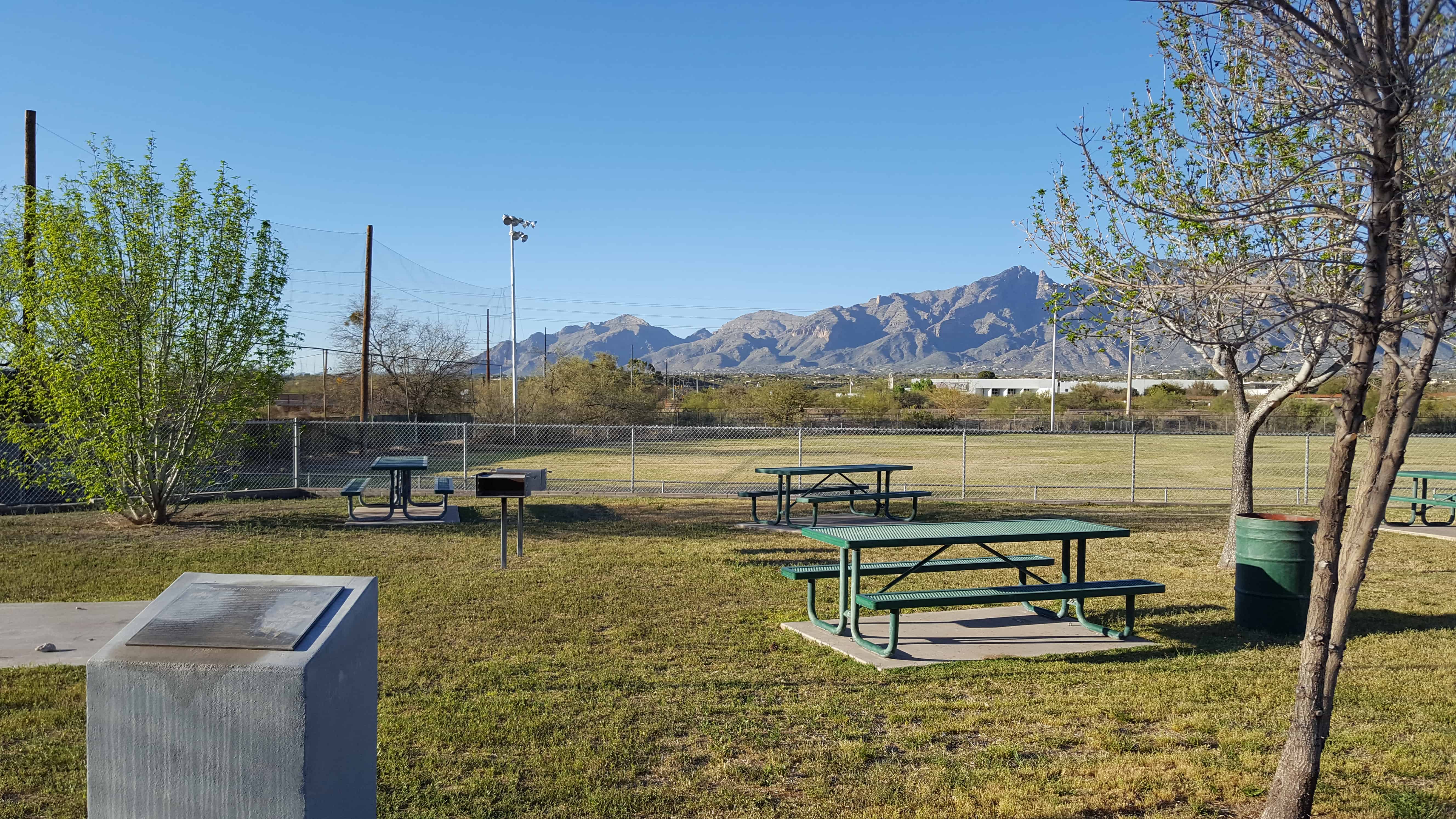
The first members of The Church of Jesus Christ of Latter-day Saints to enter what is now Arizona were remnants of the Mormon Battalion. They arrived in the Valley of the Tucson Basin December 17, 1847, prepared for battle. However, the Mexican Garrison refused to surrender and departed with most of the population. The Stars and Stripes were raised over the ancient Indian village. This march accomplished the task of pioneering a route through southern Arizona and inspired many, like Pvt. Erastas Bingham, to return with his wife and sons. They homesteaded, cleared land of mesquite, creosote, cats claw, rattlers, Gila monsters, lizards and tarantulas. Teams, plows, picks, and shovels were used to build reservoirs and irrigation systems. They called their community Binghampton, The children walked or rode on horseback or in buggies to school at Nephi Bingham’s home. School was later held in a one-room building south of the Rillito River at Fort Lowell & Maple Boulevard. In 1905 Alexander Davidson donated land for the Davidson School. Charles Bayless furnished materials, and members of The Church of Jesus Christ of Latter-day Saints donated labor. The school was used for cultural and church events. Settler families, Bingham, Farr, Young, Webb, Williams, and Hurst, were soon followed by Mormon Colonists fleeing Mexico. Colonists Langford,  Bluth, Done, Ray, Johnson, Hardy, Nelson, Stock, Evans, Terrel, Jesperson, James, Price, Cordon, Butler, Huish, Naegle, Heder, Chlarson, and others added to the bustling Mormon farm village. The Binghampton Branch of The Church of Jesus Christ of Latter-day Saints was organized May 22, 1910. Binghampton was gradually absorbed by Tucson’s growth. All that remains is the pioneer cemetery, a few adobe homes, and the chapel built in 1927, still used by ward members from the Tucson Arizona Stake.

This is DUP Marker #548, for other DUP Markers click here.

2017-03-11 17.11.10

First Latter-day Saint Chapel in Phoenix

12 Wednesday Apr 2017

Posted by Jacob Barlow in Uncategorized

≈ 2 Comments

Tags

Arizona, Arizona Historic Markers, Chapels, Churches, historic, Historic Buildings, Historic Churches, LDS Church, Maricopa County, Phoenix, SUP

2017-03-11 14.40.24

First Latter-day Saint Chapel in Phoenix

The first meetinghouse in Phoenix for The Church of Jesus Christ of Latter-day Saints (Mormons) was built on this site by the three-hundred-member congregation of the Phoenix Ward. At the time, J. Robert Price was bishop.

Since their beginning in 1912 with nine members, the Latter-day Saints in Phoenix had met in four different locations – – the Knights of Pythias Hall at 23 East Washington Street, a laundry at 534 West Washington Street, an old Spanish-style building at 121 South First Avenue, and a room over a bicycle shop at 237 North Fifth Street. They purchased this area on the eastern edge of Phoenix’s original city plat and built their first chapel 1918-1919.

The handsome meetinghouse – – designed by Pop and Burton, Architects, of Salt Lake City – – was an early example of the influence Frank Lloyd Wright’s architecture had in the Southwest. The Latter-day Saints worshipped here for nearly thirty years. Phoenix used it as a community center, and weekly businessmen’s luncheons and youth dances were held in the building.

By 1923, a thriving congregation (ward) of 730 made it necessary to expand the building; after further expansion in 1926, the meetinghouse filled this plaza area. Other wards were organized and more chapels were built, but the Phoenix First Ward continued to meet here until 1948, and Brill was completed. The building on this site was sold to another church and eventually demolished in 1969.

Bishop J. Robert Price, 1918-1926
Bishop George F. Price, 1926-1928
Bishop John H Udall, 1928-1938
Bishop Arch B. Campbell, 1938-1950

Placed 1981
Sons of Utah Pioneers, Salt River Chapter and Historic Arts and Sites Committee of The Church of Jesus Christ of Latter-day Saints

Plaque located in Heritage Square.

See other historic markers in the series on this page for SUP Markers.

2017-03-11 14.40.13

2017-03-11 14.42.06

Discovery of Zion Canyon

16 Thursday Mar 2017

Posted by Jacob Barlow in Uncategorized

≈ Leave a comment

Tags

DUP, historic, Historic Markers, LDS Church, Springdale, utah, Washington County, Zion Canyon

2017-03-04 16.21.14

DUP Marker # 42 in Springdale.

In 1858, Nephi Johnson, one of Brigham Young’s scouts, with a party of Indian guides arrived at the mouth of the canyon. Due to superstition, the Indians refused to enter the canyon. Nephi Johnson, alone, followed up river to the Narrows, a place “where the sun is seldom seen,” returning to the mouth at nightfall. Isaac Buhannin, an early settler, seeing the spires remarked, “surely this is God’s first temple and should be called Zion.” William Heaps helped to build homes for the early settlers in the canyon.

2017-03-04 16.21.09

Hill Cumorah

25 Saturday Feb 2017

Posted by Jacob Barlow in Uncategorized

≈ 1 Comment

Tags

LDS Church, New York

77873389233

Click here for more information on the Hill Cumorah’s visitor center and pageant.

77873639233

Ogden LDS Temple

25 Sunday Dec 2016

Posted by Jacob Barlow in Uncategorized

≈ 3 Comments

Tags

LDS Church, Ogden, Temples, utah, Weber County

picture19oct08-014

The Ogden Utah Temple (formerly the Ogden Temple) is the sixteenth constructed and fourteenth operating temple of The Church of Jesus Christ of Latter-day Saints (LDS Church). Located in Ogden, Utah, it was originally built with a modern, single-spire design very similar to the Provo Utah Temple. During a renovation completed in 2014, the exterior and interior were extensively changed.

350 East 22nd Street in Ogden, Utah

Koholowo

29 Tuesday Nov 2016

Posted by Jacob Barlow in Uncategorized

≈ Leave a comment

Tags

LDS Church, Nebo Loop, Santaquin

  • 51752599233

Camp Koholowo, one of the LDS Church’s camps in Santaquin Canyon.

  • 51752544233

This Is The Place Heritage Park

29 Tuesday Nov 2016

Posted by Jacob Barlow in Uncategorized

≈ 3 Comments

Tags

DUP, historic, Historic Buildings, Historic Homes, Historic Markers, LDS, LDS Church, Monuments, Salt Lake City, Salt Lake County, SUP, This Is The Place Heritage Park, utah

The location of the park is where, on July 24, 1847, Brigham Young first saw the Salt Lake Valley that would soon become the Mormon pioneers’ new home. Members of The Church of Jesus Christ of Latter-day Saints believe that Young had a vision shortly after they were exiled from Nauvoo, Illinois. In the vision, he saw the place where the Latter-day Saints would settle and “make the desert blossom like a rose” and where they would build their State of Deseret. As the account goes, Brigham Young was very sick with Rocky Mountain Spotted Fever and was riding in the back of a wagon. After exiting Emigration Canyon and cresting a small hill, he asked to look out of the wagon. Those with him opened the canvas cover and propped him up so he could see the empty desert valley below. He then proclaimed, “It is enough. This is the right place. Drive on.” The words, “this is the place,” were soon heard throughout the wagon train as the Mormon pioneers descended into the valley, their long journey having come to an end. The statement was first attributed to Young by Wilford Woodruff more than thirty years after the pioneer advent.

Over the next several years, tens of thousands of Mormon pioneers emerged from Emigration Canyon and first saw their new home from this same location. A Utah state holiday, Pioneer Day, occurs each year on July 24 to commemorate the Mormon pioneers’ entry into the valley.

See also:

  • Angels Are Near Us
  • Anson Call
  • Eyes Westward
  • First Company of Pioneers into the Valley
  • Green Flake
  • Hark Wales & Oscar Smith
  • Israel and Elizabeth Haven Barlow
  • Jane Elizabeth Manning
  • This Is The Place Obelisk
  • This is the Place State Park (monument)
  • The Riter Cabin
  •  
  • Official Website
  •  

Located at 2601 Sunnyside Avenue in Salt Lake City, Utah

For other State Parks in Utah visit this page. and for other parks in Salt Lake this page.

Mission San Luis Rey De Francia

20 Sunday Nov 2016

Posted by Jacob Barlow in Uncategorized

≈ 2 Comments

Tags

California, Catholic, historic, Historic Markers, LDS, LDS Church, Oceanside, San Diego County

picture27dec07-071

The historical marker reads as follows:

MISSION SAN LUÍS REY DE FRANCIA

Founded June 12, 1798 by Father Lasuén, then president of the California missions, and administered by Father Peyrí, Mission San Luís Rey is notable for its impressive architecture-a composite of Spanish, Moorish, and Mexican.

The following text was copied from Wikipedia.
Mission San Luis Rey de Francia was founded on June 13, 1798 in what is now the town of Oceanside, California. In 1816, Mission San Antonio de Pala was established twenty miles inland as its asistencia (“sub-mission”). The local Payomkowishum tribe became known as the Luiseño, after the San Luis mission. An early account of the mission was written by one of its Luiseño neophytes, Pablo Tac.

No services were held at the Mission for 46 years. It was not until 1892 when two Mexican priests were given permission to restore the Mission as a monastery; Father Joseph O’Keefe was assigned as an interpreter for the monks. It was he who began to restore the old Mission in 1895. The cuadrángulo (quadrangle) and church were completed in 1905. Today, Mission San Luis Rey de Francia is a working mission. It is cared for by the people who belong to the parish, and is still being restored. There is a museum and visitors center at the Mission, as well as a small cemetery.

picture27dec07-069

picture27dec07-070


Located at 4050 Mission Ave in Oceanside, California.

Also located here:

  • The Mormon Battalion (historic marker)

Related:

  • The Mormon Battalion

Arizona’s Honeymoon Trail

19 Saturday Nov 2016

Posted by Jacob Barlow in Uncategorized

≈ 1 Comment

Tags

Arizona, DUP, historic, LDS, LDS Church, Maricopa County, Mesa

2016-09-05-17-24-06

DUP Marker #532 – Located in Mesa’s Pioneer Park.

Arizona’s Honeymoon Trail

For nearly forty years, couples from Arizona settlements left their homes each fall after harvest and traveled 400 miles to St. George, Utah. Winding slowly through desert and steep canyons, crossing barren plateaus, and passing rivers and pools of undrinkable water, these travelers made their way to be married in the St. George Temple, the only temple completed at that time. The trail followed the old wagon road across the Colorado River at Lee’s Ferry. Couples from Snowflake and Taylor were the first known to make the trip in 1881. Some couples married in civil ceremony before leaving, while others were escorted by chaperones. A few couples, waiting to afford the trip, had children who accompanied them. Frequently couples banded together for the trip. Before leaving on the long, hazardous journey, wagons were loaded with food packed in grub boxes, and water barrels were mounted on the wagon sides. Supplies of hay and grain for the animals were also transported. When needed, settlers along the way furnished food and water from their meager supplies.

Because of the romantic nature of these adventures, reporter Will C. Barnes gave the route its name, The Honeymoon Trail. After the Atlantic Pacific Railroad was completed in 1885, a few couples went by train, and later by auto. When the Mesa Arizona Temple was dedicated in 1927, the journey was no longer necessary. The old trail still is visible in a few places. The route was added to the National Register of Historic Places in 1986. This slender thread that connected the Arizona settlements to the St. George Temple became an enduring testimony to the faith of these settlers, members of The Church of Jesus Christ of Latter-day Saints. A pattern of sacrifice aided the pioneers in settling the Arizona and New Mexico wilderness.

2016-09-05-17-23-54
2016-09-05-17-23-09

Mesa

19 Saturday Nov 2016

Posted by Jacob Barlow in Uncategorized

≈ 1 Comment

Tags

Arizona, DUP, historic, LDS, LDS Church, Maricopa County, Mesa

2016-09-05-17-23-33

DUP Marker #169 – Located in Mesa’s Pioneer Park.

Mesa

Early in 1878 a hardy band of Mormon pioneers arrived on this mesa. With a straight edge and a spirit level they proved the feasibility of using the ancient Montezuma Canal to bring life-giving irrigation water from the Salt River to the desert sands. On February 14th work began on this project. A survey was made and stakes driven, May 16, 1878, to plat the townsite according to the “City of Zion” plan given by Joseph Smith, the founder of the Church of Jesus Christ of Latter-Day-Saints. Elijah Pomeroy was the first Bishop of Mesa and A. F. McDonald the first Mayor. Maricopa County

2016-09-05-17-23-54
2016-09-05-17-23-26


← Older posts
Newer posts →

Follow Jacob

Follow Jacob

Come wander with me on Youtube.

Blog Stats

  • 2,098,524 hits

Social and Other Links

BarlowLinks.com

Recent Posts

  • Scout Monument
  • Provo High School Seminary Building
  • 821 E 100 S
  • 820 E 100 S
  • 817-819 E 100 S

Archives

Loading Comments...