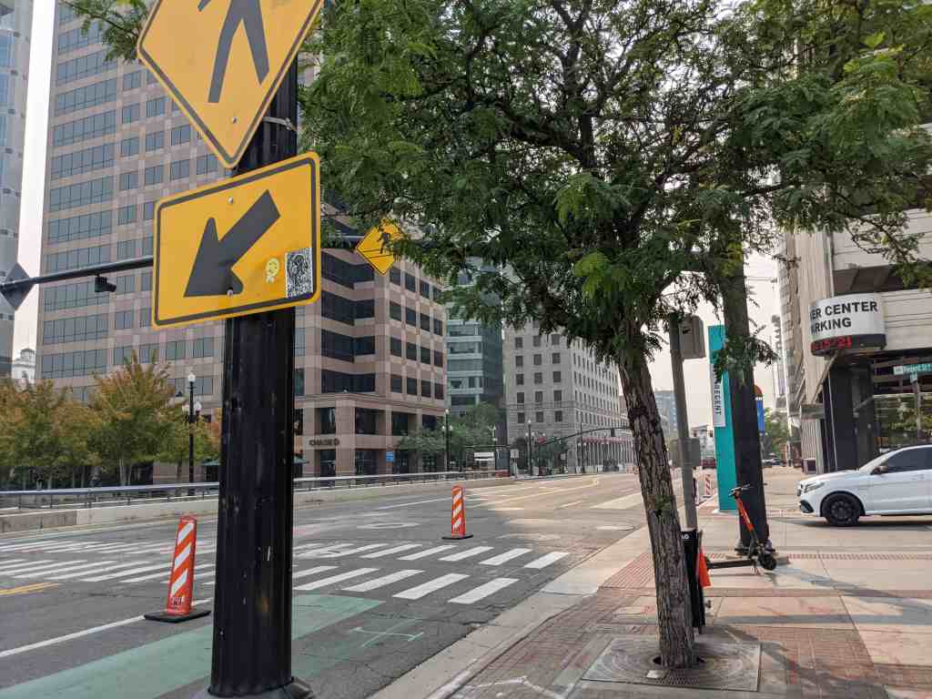
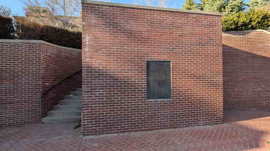
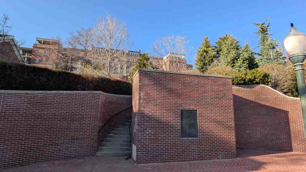
Bishop Robert Sherwood, January 27, 1858 – August 6, 1942, donated parcels of this land known as Sherwood Forest Addition for perpetual public use on July 12, 1890.
In 1855, upon the counsel of Brigham Young, Joseph Harker, with John and Samuel Bennion, hand-dug the lower ditch to irrigate the farmland on the river bottoms west of the Jordan River.
A small rock dam was constructed on the Jordan River at about 6300 South. Water was taken from the river at that pointand came north to the park site. The ditch skirted the west and north boundaries of the park and then north to the mill.
In 1880, a new grist mill was constructed on the Jordan River near 4800 South. Water was taken from the Lower Ditch to power the mill and the name MILLRACE was applied to the ditch.
Sons of Utah Pioneers historic marker #117 erected in 2005 by the Taylorsville Bennion Sons of Utah Pioneers, it is located in Millrace Park at 1200 West 5400 South in Taylorsville, Utah
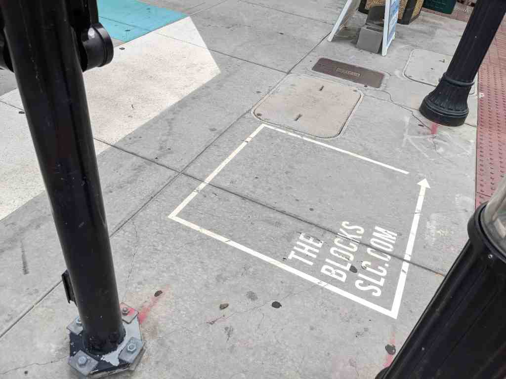
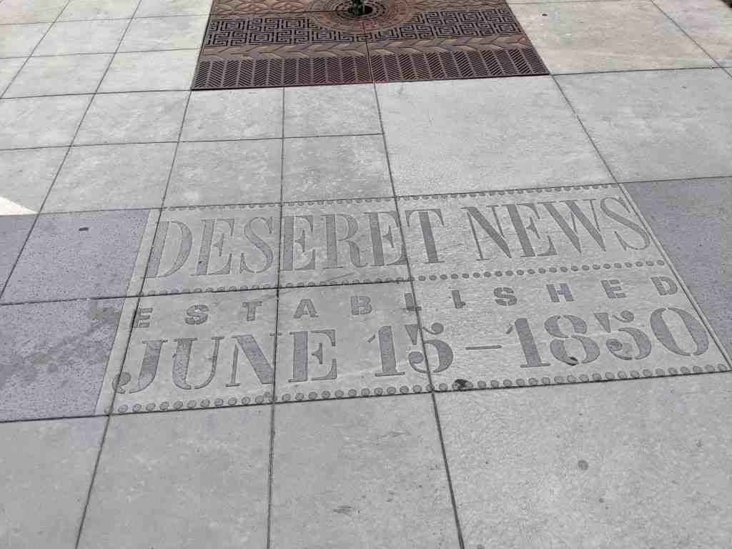
Inspired by the printing presses of Regent Street that busily churned for years publishing The Salt Lake Tribune and Deseret News, the Regent Street press sheet winds its way down the street.
Along its meandering path you’ll find stories about the long and diverse history of this part of Salt Lake City. Once called Commercial Street, Regent Street has been the site of Salt Lake City’s red light district, a home to Chinese immigrants in the late 19th century, a center for headline news in the 20th century, and now is at the heart of the city’s cultural core.
“In those days the hot spots of Salt Lake were located in a tidy manner on a street that ran between 1st and 2nd South and Main and State. Within the street were saloons, cafés, parlor houses, and cribs that were rented nightly to the itinerant ladies of the calling. It was against the rules to solicit, so these soiled doves would sit at the top of the stairs and coo their invitation to ‘C’mon up, kid.'” – John Held, Jr.
John Held, Jr. (1889-1958) was an American cartoonist, printmaker, and one of the best known magazine illustrators of the 1920s. He worked as a cartoonist at The Salt Lake Tribune and illustrated covers for LIFE, The New Yorker and Vanity Fair.
Plum Alley ran north and south dividing the city block between Main and State Streets, the cross streets being 100 South and 200 South. During the early 20th century, within and around Plum Alley, the Chinese developed a microcommunity with grocery and merchandise stores, laundries and restaurants.
“On New Year’s Day they had a big New Year’s celebration in Plum Alley, some of them old guys would come over and give us the red envelopes with lucky money in them. That was quite a haul, when you’d get up there you might get twenty bucks in silver dollars.” – Henry Ju
Henry Ju (1923-1990) was the son of Joy Ju, one of the first merchants on Plum Alley. The family store, Wo Sang, sold merchandise such as chinaware and silk from China.
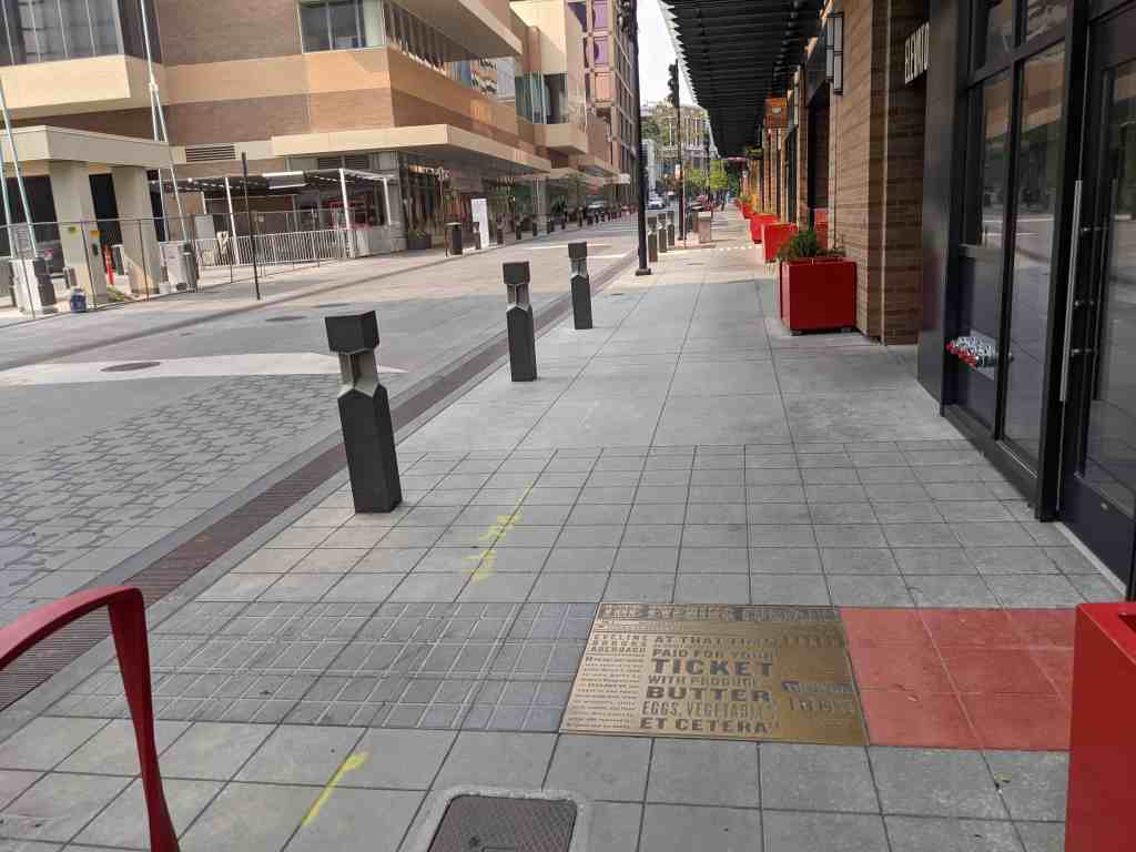
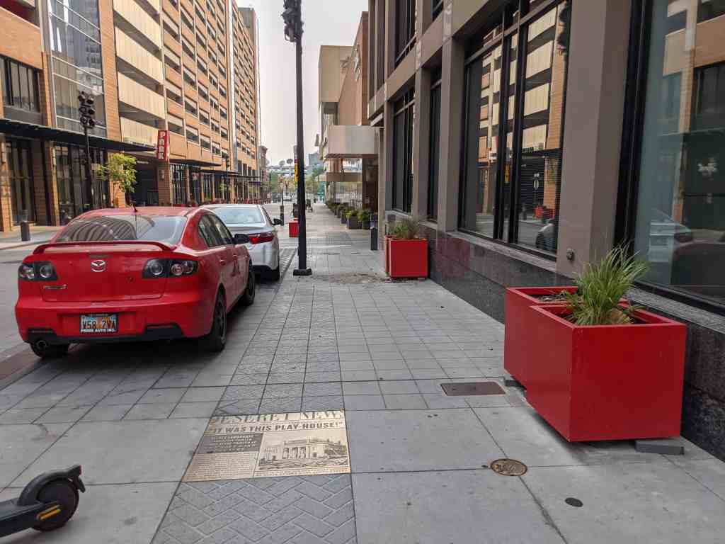
“The Salt Lake Theatre was opened to the public March 8, 1862. It was built by Brigham Young at a cost of $200,000.00 and equal to any opera house in the East. It had an orchestra, stalls, first, second, and third circle, three boxes on either side reserved for Brigham and his family. At that time no money was in circulation, and you paid for your ticket with produce – butter, eggs, vegetables, et cetera.” – Eveline Brooks Auerbach.
Eveline Brooks Auerbach (1859-1924) was born in the California mining town of Timbucktoo in 1859. Her family lived as merchants in various towns in the western U. S., eventually settling in Salt Lake City. In 1879 she married Samuel Auerbach, a German-Jewish immigrant in the goods business in Salt Lake City. She raised a family and lived in Salt Lake City for most of the rest of her life. Her published memoir touched on business and social conditions as well as relations among religious groups.
“We will have to go to work and get the gold out of the mountains to lay down, if we ever walk in streets paved with gold.” – Brigham Young, an original settler of Block 70.
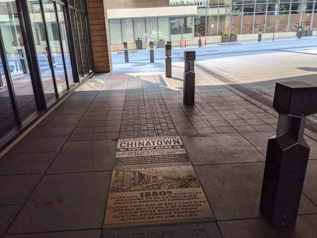
For more than half a century, Plum Alley & Regent Street were home to Salt Lake City’s Chinatown. Almost 1,000 people lived and worked on Plum Alley at its zenith in the 1890s.
Many Chinese people immigrated to the western United States in the second half of the nineteenth century to build the first transcontinental railway – completed May 10, 1869.
By the late 1880s Plum Alley was home to an established Chinese-American community – during that era in Salt Lake City, nearly all people of Chinese origin were barred from renting or owning property outside of Plum Alley.
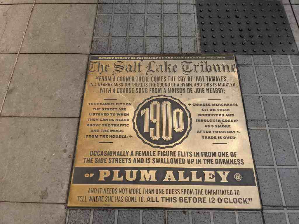
“From a corner there comes the cry of ‘hot tamales,’ in a nearby mission there is the sound of a hymn, and this is mingled with a coarse song from a Maison De Joie nearby; the Evangelists on the street are listened to when they can be heard above the traffic and the music from the houses; Chinese merchants sit on their doorsteps and indulge in gossip and smoke after their day’s trade is over; occasionally a female figure flits in from one of the side streets and is swallowed up in the darkness of Plum Alley and it needs not more than one guess from the uninitiated to tell where she has gone to. All this before 12 O’clock.” – The Salt Lake Tribune – 1900
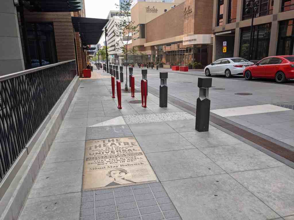
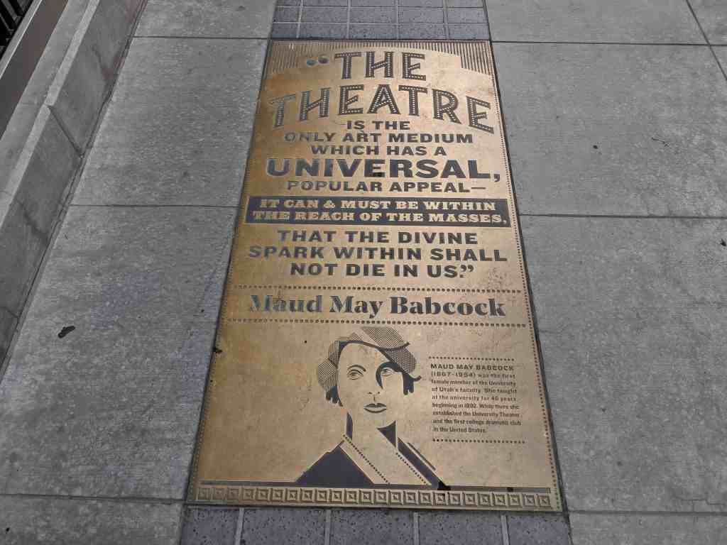
“The theatre is the only art medium which has a universal, popular appeal – it can & must be within the reach of the masses, that the divine spark within shall not die in us.” – Maud May Babcock
Maud May Babcock (1867-1954) was the first female member of the University of Utah’s faculty. She taught at the university for 46 years, beginning in 1892. While there she established the University Theater and the first college dramatic club in the United States.
“It was one of President Young’s prides to have it a perfectly high class place of amusement – no detail was too small for him to supervise and he was justly proud of the results.” – Sara Alexander – Pioneer era star of the stage. (The Salt Lake Theatre – 1861)
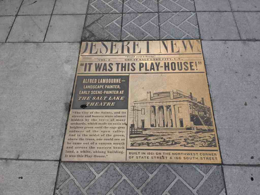
“The City of the Saints, and its street and houses were almost hidden by the trees of many orchards, which made and oasis of brighter green amid the sage-gray sadness of the open valley. And in the midst of the green, above the trees, one could see as he came out of a canyon mouth and across the eastern bench land, a white, oblong building. It was this Play-House.” – Alfred Lambourne – Landscape painter, early scene-painter at The Salt Lake Theatre.
Built in 1961 on the Northwest corner of State Street & 100 South Street.
Pony Express Riders sworn oath:
“I, do hereby swear before the great & living God that during my engagement & while I am an employee of Russell, Majors & Waddell – I will under no circumstances use profane language, I will drink no intoxicating liquors; that I will not quarrel or fight with any other employee of the first and that in every respect I will conduct myself honestly, faithful to my duties, & so direct my acts, as to win the confidence of my employers, so help me God.”
Salt Lake City’s Pony Express Station was located at 143 South Main Street.
“One cannot be pessimistic about the West. This is the native home of hope. When it fully learns that cooperation, not rugged individualism, is the quality that most characterizes and preserves it then it has a chance to create a society to match its scenery.” – Wallace Stegner
Wallace Earle Stegner (1909-1993) was an American novelist, environmentalist, and historian. Although he had lived in many places, he always referred to Salt Lake City as his “hometown.” Educated at the University of Utah, he is considered among the most influential Western writers and won the Pulitzer Prize in 1972.
History of Salt Lake City’s Red Light District
The growth of Salt Lake City in the 19th century mirrored that of other Western cities in many respects, including prostitution. A red light district emerged on Regent Street in the 1880s and continued to exist there through the early 20th century, with some brothels persisting on Regent until the 1930s. Regent Street’s location within the commercial district on Block 70’s interior made it a setting where prostitution was tolerated as it was not easily visible from the major streets surrounding it. Brothels were unofficially regulated (through intermittent arrests and fines for people engaged in the trade) in this area until 1908, when the red light district was moved to the west side of Salt Lake City.
Describing the area in 1900, The Salt Lake Tribune stated: “From a corner there comes the cry of ‘hot tamales,’… in a nearby mission there is the sound of a hymn, and this is mingled with a coarse song from a maison de joie nearby; the evangelists on the street are listened to when they can be heard above the traffic and the music from the houses; Japanese, Chinese, negroes, and white mix together in a friendly way; occasionally from one of the saloons some tough… is seen to shoot out of a door-he doubles his fist, Vows vengeance and then slides away; out from a dark and badly-scented alley comes a pale-faced man whose chief occupation in life is to smoke opium; Chinese merchants sit on their doorsteps and indulge in gossip and smoke after their day’s trade is over; … occasionally a female figures flits in from one of the side streets and is swallowed up in the darkness of Plum Alley, and it needs not more than one guess from the uninitiated to tell where she has gone to. All this before 12 o’clock.”
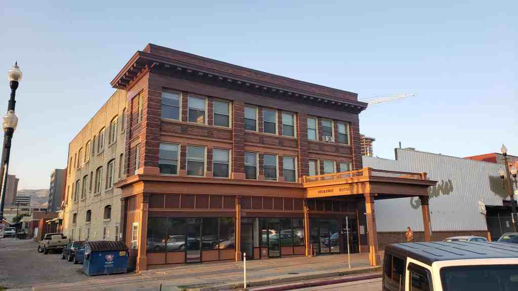
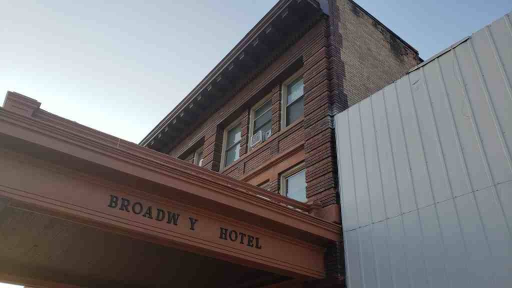
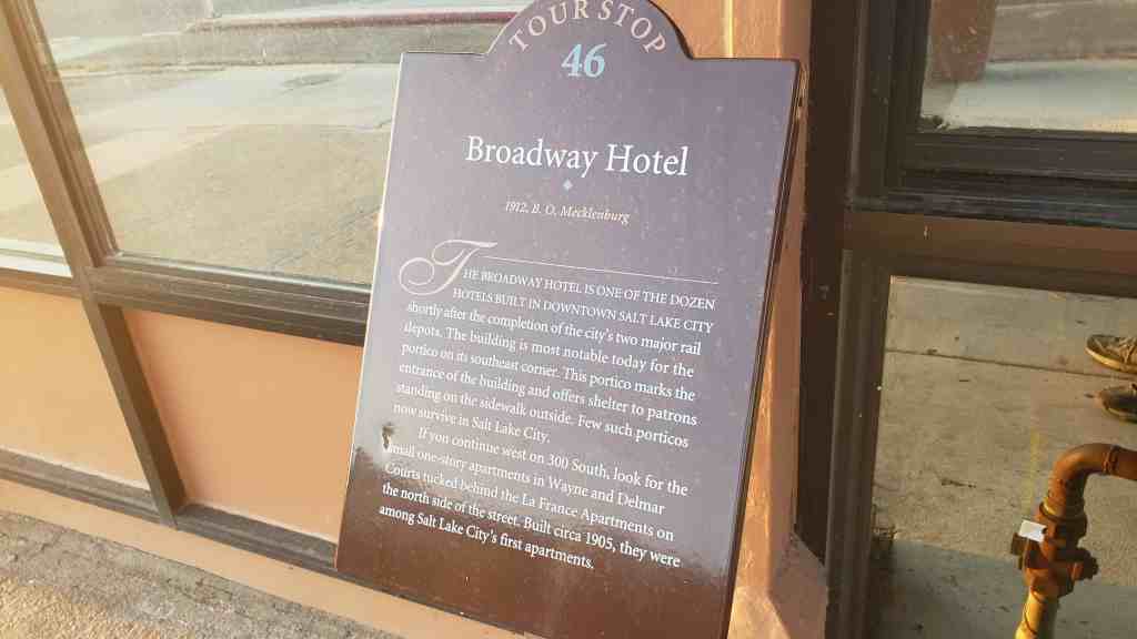
The Broadway Hotel is one of the dozen hotels built in downtown Salt Lake City shortly after the completion of the city’s two major rail depots. The building is most notable today for the portico on its southeast corner. This portico marks the entrance of the building and offers shelter to patrons standing on the sidewalk outside. Few such porticos now survive in Salt Lake City.
If you continue west on 300 South, look for the small one-story apartments in Wayne and Delmar Courts tucked behind the La France Apartments on the north side of the street. Built circa 1905, they were among Salt Lake City’s first apartments.
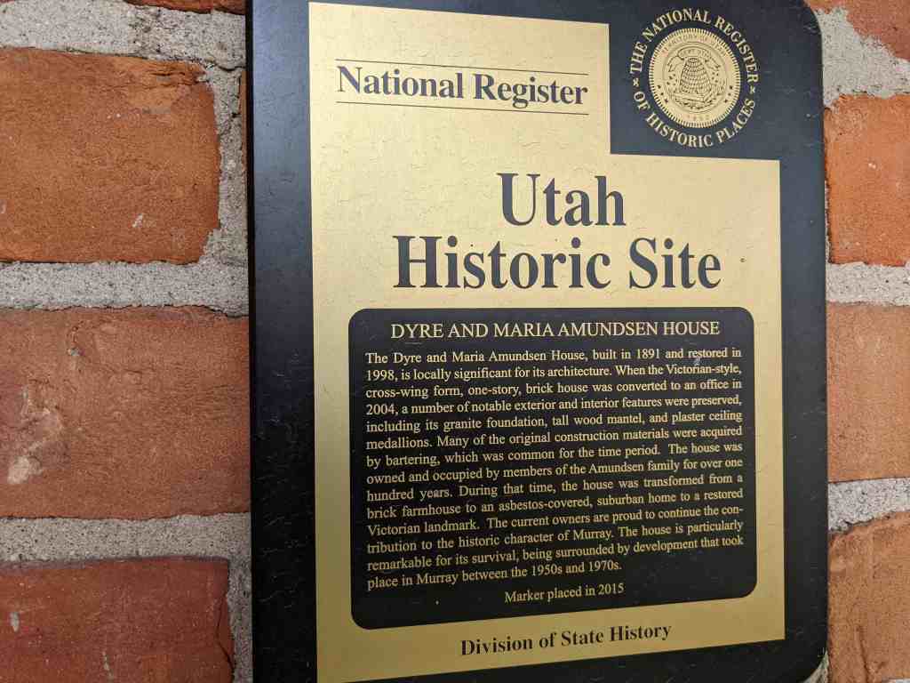
The Dyre and Maria Amundsen House, built in 1891 and restored in 1998, is locally significant for its architecture. When the Victorian-style, cross-wing form, one-story, brick house was converted to an office in 2004, a number of notable exterior and interior features were preserved, including its granite foundation, tall wood mantel, and plaster ceiling medallions. Many of the original construction materials were acquired by bartering, which was common for the time period. The house was owned and occupied by members of the Amundsen family for over one hundred years. During that time, the house was transformed from a brick farmhouse to an asbestos-covered, suburban home to a restored Victorian landmark. The current owners are proud to continue the contribution to the historic character of Murray. The house is particularly remarkable for its survival, being surrounded by development that took place in Murray between the 1950s and 1970s.
Located at 307 East Winchester Street in Murray, Utah and added to the National Historic Register (#15000131) on April 6, 2015.
The Dyre and Maria Amundsen House, built in 1891 and restored in 1998, is locally significant under Criterion C in the area of Architecture. Although the Victorian-style one-story brick house was converted to an office in 2004, a number of notable exterior and interior features have been preserved. These include the granite foundation, a tall wood mantel, and plaster ceiling medallions. The house was owned and occupied by members of the Amundsen family for over one hundred years. During that time, the house was transformed from a brick farmhouse for a major farmstead to an asbestos covered suburban home to a restored Victorian landmark. The house is particularly remarkable for its survival at the edge of an explosion of residential and commercial development that took place in Murray between the 1950s and 1970s. The period of significance dates from the construction of the house in 1891 to the remodeling in 1951. The house is a particularly elaborate early example of a cross-wing Victorian cottage in Murray, especially considering the construction materials were acquired by the barter system common for the time period. The property meets the registration requirements under the Multiple Property Submission, Historic Resources of Murray City, Utah, 1850–1967. The associated historic contexts are “Early Residential and Agricultural Buildings of Murray, 1850-1910” and the “Americanization of Murray’s Residential Architecture, 1902-1965.” The Dyre and Maria Amundsen House has good historic integrity and contributes to the historic character of its Murray neighborhood.
When the Amundsen House was built in 1891 in the Victorian Eclectic style, it did not have the visual complexity of contemporaneous homes in the fashionable urban neighborhoods of Salt Lake City. The house did have a simple elegance that was suited to its rural setting. The unknown builder used a modified cross wing plan and a variety of materials to achieve the visual interest that is characteristic of the Victorian-era domestic architecture in Utah. Dyre Amundsen helped to haul granite blocks for the construction of the Salt Lake City LDS temple and family oral tradition suggests that Amundsen was given permission to select cast-off blocks for personal use. Much of the wood used in the house came from locust trees that Dyre Amundsen planted in the late 1860s or early 1870s. The red and contrasting yellow bricks were likely produced at the local brickyard in Murray. The brick and windows were paid for by a one-acre crop of potatoes. The interior spaces in the south half of the house are larger than the typical house of the period. Family tradition states that Dyre Amundsen received the two large plaster ceiling medallion moldings from the LDS Church as payment for hauling the granite blocks. The brick moldings, granite blocks, ceiling medallions, wide corridors, are atypical for a Victorian-era cross-wing house of the period in Murray.
The Amundsen House as a product of the Victorian period marks a pivotal point in Murray’s history. The availability of kiln-dried brick in the 1860s and the coming of the railroad in the 1870s transformed Murray’s domestic architecture from vernacular buildings to Victorian forms with asymmetrical massing and a variety of texture. The Victorian cottage was the most popular house type in Murray between 1884 and 1910. Dyre and Maria Amundsen originally built an adobe house on their homestead in the late 1860s, then worked many years to afford the spacious brick home that built in 1891. In the post World War-II era, the old brick house may have seemed out-of-date as frame cottages and brick ranch houses were built on the former Amundsen homestead. The family had the house covered with asbestos siding in 1951 effectively suburbanizing it for the next generation. The 1996 to 1998 rehabilitation of the house restored much of the Victorian elegance and was awarded a Utah Heritage Foundation award in 1999.
Dyre Amundsen was born on June 11, 1837, in Gernserud Buskerud, Norway. The family name was Anunsen in Norway. Dyre immigrated to Utah in 1862. While helping to bring other immigrants across the plains in 1863, Dyre Anunsen met and married Beata Erickson, who died in October 1863, only a month after their marriage. Dyre was living in South Cottonwood in 1865 when he met Sophia Maria Person. Maria Person was born in Marna, Sweden, in 1833.2 She immigrated to Utah in 1864.
Dyre and Maria were married in October 1865.3 They lived with the Wheeler family until a small cabin was built for them on Andrew Hammer’s property. Their son, John David, was born in the cabin in December 1867. Dyre Anunsen served in Utah’s Black Hawk War in 1866 and was award a medal for his service. Sometime in 1867 or 1868, Dyre Anunsen claimed a homestead on land along the angled land that would become 6400 South. As a latecomer to the area, his homestead of 160 and 37/100s of an acre was in the shape of an upside down “T” and claimed in three separate parcels. Dyre built a two-room adobe house for his family where a daughter, Sarah Ann, was born in January 1870. A second daughter, Marinda, was born there in April 1873. The adobe house was located west of the later brick house. Dyre was a logger and a farmer. One of the first projects he completed on his homestead was planting a grove of locust trees. The family would later use the wood to build a barn, fences, and the woodwork in the brick house. On February 20, 1875, Dyre Anunsen was granted a land patent for his homestead property.
The Anunsen begin using the name “Amundsen” in the 1880s. In 1891, Dyre filed a deposition with Salt Lake County to change the name on his deeds. The brick house was built in 1891. The builder is unknown, but Dyre himself may have placed the granite foundation blocks that he acquired. The bricks, windows, and other building materials were paid for by an acre of potato crop. The plaster ceiling medallions were reportedly given to Dyre in payment for hauling some of the granite for the Salt Lake temple.4 The Amundsen house and property were at the southern edge of Murray City after annexation in 1905. Dyre Amundsen died on November 17, 1906. He is buried in the Murray Cemetery. At the time of his death, the homestead property had been reduced by more than a half. The land and its water shares were divided between Maria Sophia Amundsen and her three children. Both daughters, Sarah Ann Amundsen Jensen and Marinda Amundsen Boyce, had been married several years and were living in Idaho. In 1909, Maria Amundsen deeded her acreage to her son John David, but retained a life estate. Maria Sophia Amundsen died on August 9, 1918. Her funeral was held in the Grant Ward meetinghouse and she was buried in the Murray Cemetery.
John David Amundsen married Alma Pauline Janson on September 19, 1899. Alma was born in Sweden in 1860 and immigrated to Utah in 1897. On the 1900 census, John David (as David) and Alma are living with his parents, Dyre and Maria. David and Alma had three children: Alice Engre Sophia (born in 1901), Edith Selma Lenora (1903), and Wallace Janson (1906). In a letter describing the history of the house, Edith’s daughter-in-law, Linda Adams, wrote that “the house became two dwellings [Edith’s] parents occupying the three rooms on the West side and her grandparents the two rooms on the East.”5 Edith recalled the driveway was lined with “tall stately poplar trees” and her grandmother had planted the front yard with “yellow roses and Mormon tea vine.” The rest of the yard was planted with “as many shrubs as possible to keep the dust down.”6 David and Alma kept the land as productive as they could, raising vegetable, hay, and sugar beets.
The early settlement of the area began soon after the members of the Church of Jesus Christ of Latter-day Saints (LDS or Mormon) began arriving in the Salt Lake Valley in 1847. Mormon pioneers quickly spread out from Salt Lake City in search of suitable agricultural land. By 1848 a settlement in the area later known as Murray was established eight miles south of Salt Lake City. The settlement was first called South Cottonwood and was a community of scattered farmsteads originally extending from the Big Cottonwood Creek to the southern end of the Salt Lake Valley, east to the Wasatch Mountains, and west to the Jordan River. As more settlements were established in the south valley, the name South Cottonwood was retained by a group of farmers organized as the South Cottonwood Ward of the LDS Church. An adobe meetinghouse, located at the corner of Vine Street and 5600 South, was the community center for the group. The main north-south corridor was the Territorial Road (later State Street). The Salt Lake City & Jordan Canal and the East Jordan Canal were dug to bring water from the Big and Little Cottonwood Creeks to the farmsteads between South Cottonwood and the settlement of Union to the southeast.
The north half of the South Cottonwood did not remain rural. At the west end Vine Street, an industrial and commercial center began to grow in response to several smelters that were established near the railroad lines west of State Street in the early 1870s. In 1883, the name Murray (after the territorial governor, Eli Murray) was adopted for the town’s official postal designation. The name Murray became official during the incorporation of the city in 1903. At the time of incorporation the boundaries of the city extended from approximately 4500 South to 5600 South, and 900 East to 900 West. In 1905, the city boundaries were extended south to include both sides of 6400 South, which was the main east-west corridor and marked the south boundary of the historic South Cottonwood community.
During the first half of the twentieth-century, Murray City was an industrial town with its own power plant, water system, and school district. Residential development took place near the city center or along the major transportation routes, while the outlying areas continued as farmland. After the last remaining smelter closed in 1950, Murray City with its stable infrastructure and centralized location experienced a post-war suburban building boom. The population jumped from 5,740 in 1940 to 21,206 in 1970. Between 1946 and 1967, sixty seven subdivisions of mostly single-family ranch houses were platted within the boundaries of Murray City. In 1972, commercial property along State Street between 6100 and 6400 South was consolidated for the construction of the Fashion Place Mall. The opening of the mall was planned to coincide with the construction of the Interstate-215 belt route just south of 6400 South. Since the 1970s, the commercial development around the mall has spread along 6400 South east to 900 East. Only a few historic homes, such as the Dyre and Maria Amundsen House, remain to tell the story of the neighborhood’s agricultural past
The census indicates all three grown children were living at home in 1930. Alice worked as a stenographer, Edith was a saleslady for a dry goods store, and David and Wallace worked the farm. David deeded approximately eleven acres in the north half of the property to Wallace in 1931. Alice Amundsen died of influenza in May 1933. One month later, Edith Amundsen married Bronson Adams. Bronson Howard Adams was born in Beaver, Utah, in 1908. Bronson and Edith moved away for a short time, but returned to live at the Amundsen House in 1934. It would be the only time in her life that Edith did not live in the family house on 6400 South. Alma Pauline Janson Amundsen died in February 1936. John David Amundsen died in December 1939. That year, Wallace Amundsen, who remained a bachelor, gave Edith his share of the property with the family home. Wallace Amundsen was living with Edith’s family on the 1940 census, but later moved to an adjacent home at 353 E. 6400 South. He died in 1979.
Edith and Bronson Adams had three children, Kathleen, Patricia, and Howard. Bronson worked in sales and as a warehouseman before starting a career with the Union Pacific Railroad. In July 1949, Bronson Howard Adams died during an operation at the age of forty. In order to care for her family and pay the taxes, Edith sold off much of the family property by the mid-1950s. The covering of the brick house in asbestos shingles in 1951 occurred just after the first postwar subdivision in the south half of Murray was developed between 1946 and 1950. Two of the largest subdivision developments in Murray, Murray Dale and the Murray Dale Addition, were platted in 1953 and 1954, north and east of the Amundsen house on land that was formerly part of the Amundsen farmstead. Edith Adams graduated from the Salt Lake Business School and worked for the Frank Edward Company until her retirement in 1970. When she passed away on October 15, 1995, she was recognized as a lifelong resident of Murray. After her death, her son Howard and his wife Linda, restored the family home. They were assisted by Dan Lossee, a local architect. The home was rented intermittently by family members and others before being sold to Tamra Lee, the owner of the Mt. Olympus Title Company in 2004.9 Although a busy title company office, the house maintains its domestic charm.
Narrative Description
The original footprint of the Amundsen House is a rectangle of 40 feet by 26 feet with a six-foot projecting wing at the southwest corner. The foundation is made from large rock-faced granite blocks. The red brick is laid in a common (American) bond with headers every seventh course. The mortar joints are flush and are a contrasting light tan. There is plain wooden frieze (painted tan) under the eaves. The west projecting wing has a hipped roof. The main wing runs west to east with a simple gable that has been extended to the north. The bell cast extension of the roof above the front porch was made during the 1998 renovations. The wood shingles were installed at the same time. The south projection has two narrow Victorian windows with ornamental drip hood moldings of segmented and corbelled brick in a contrasting tan color. The sills are corbelled rowlock brick. The moldings and the original wood sills were damaged and replaced in 1998.
The current wood windows were installed in 1998, but are similar to the original one-over-one, double-hung windows, which were too damaged to repair. The west elevation has three openings with similar windows with a pair in the center. The treatment of the front door and two windows on the main wing’s façade are the same. The half-glass front door with transom is original, although the glass has been replaced with decorative leadedglass. The front porch is the only major modification to the façade. It is full width rather than the entrance-only porch of the original and wraps around the east side to the bay addition. The new Victorian-style porch features a concrete base with a wood plank deck. The slender lathe-turned posts and balustrade were installed in 1998, but are compatible with the Victorian-style.
The north half of the house was slightly lower and set back on the east elevation. Tax records indicate that by the late 1930s, the house had a 9 feet by 14 feet lean-to addition and a 5 by 7 feet screened porch on the rear elevation. The original east elevation had two windows, one in the taller south half and one in the shorter north half. The rear porch was enclosed and expanded around 1951 when the entire house was clad in pink asbestos siding. The 1951 remodeling included wood surrounds for each opening and wrought-iron supports over the front stoop. In 1996, the siding was removed. The rehabilitation of the house was completed in 1998 including installing a new roof, cleaning the brick, and installing the replacement wood windows. The brick chimney at the center of the house was originally much taller with a corbelled cap. In 1951, it was shortened, but is still operable. A compatible brick addition on a concrete foundation was designed to replace the rear lean-to and enclosed porch addition. A new bay window has altered the historic footprint along the east elevation. The addition matches the details on the original house, but can be distinguished by the use of newer materials.
On the interior, the Amundsen House has 1,844 square feet of space on the main floor. The house has no basement or cellar. The attic space is not useable. The interior features an unusually wide central passage and 12-foot-high ceilings. The parlor to the west features the original carved wood mantel with a mirror inset. The hearth and firebox was replaced with stone tile in 1998. Other original woodwork such as the fluted and paterae window casings and the tall baseboards are intact. The ornamental plaster ceiling medallions in the parlor and living room are original, but the light fixtures are period antiques that were obtained from the Hotel Utah in Salt Lake City. Behind the parlor is the original home’s only bedroom (closet added in 1998). The kitchen is north of the living room on the east side of the house. The east projection, built in 1998, is a conference room. The wallpaper was selected to match the original as seen in family photographs. The French doors and newer woodwork match the style of the original features. The bathroom at the north end of the hall was moved to the east, to provide access for the rear addition. The addition features two rooms and a central bathroom. The spaces have been used for offices since 2004; however, the house could be returned to residential use.
The current 0.53 acre site is only a fraction of the original 160-acre homestead. The unusual shape of the parcel is partially a result of a number of factors: subdivision development to the north, substation expansion to the west, and the busy Winchester Street (6400 South) and Fashion Boulevard intersection, which leads to the Interstate-215 interchange. The driveway originally accessed 6400 South, but was reconfigured in 1998 to provide access from 300 East. The contributing 1930 frame one-car garage is located northeast of the house.1 The space between the concrete driveway and 6400 South is landscaped with evergreens and bark. There is lawn on three sides of the house. There is a large vegetable garden plot in the northeast portion of the lot. Fencing is a combination of brick pier, white vinyl, and chain link.
The immediate neighborhood is a mix of large-scale commercial and single-family residential. The Fashion Place Mall (1972) is directly west of the substation and commercial development has spread along the south side of Winchester Street. On the north side of Winchester Street are historic homes, mostly from the 1940s. The neighborhood north and east of the Amundsen property is a subdivision that was developed in the mid to late 1950s. The original setting of the house has been somewhat compromised by later development, but the house has integrity of location. Minor alterations were made to the design and materials of house in 1998, but the house retains high integrity in terms of workmanship, feeling, and association of the original Victorian-style brick house. Because of its surroundings, the restored Dyre and Maria Amundsen House is a distinctive landmark and a contributing resource in its south Murray neighborhood.
The Veterans Administration (V.A.) Hospital, built in 1932 with a 1939 addition, is significant in its role of providing medical and rehabilitation services for veterans of the United States armed forces. The main building was constructed in 1932 and the annex building in 1939, fulfilling plans that had begun in 1924 to build medical facilities in response to the needs of World War I veterans in the intermountain west region. This hospital provided services to veterans of the Spanish-American War, World War I, World War II, and the Korean War, and describes the involvement of the military in providing for those who participated in war. The V.A. Hospital influenced both direct and indirect federal revenues it provided for the community. The building of the hospital helped with easing unemployment in Salt Lake City during the Depression era. It also represents the medical influences and trends in the area between the period of significance, 1932-46. The association between the V.A. Hospital and the University of Utah Medical School beginning in 1946 provided facilities, equipment, and research funding for the school and allowed the V.A. Hospital to participate in main-stream medical research and education to provide veterans with the best medical care available.
The former Veterans Hospital, now the Meridian Condos. Built in 1932 and located at 400 Capitol Park Avenue the Avenues district of Salt Lake City, Utah (also referred to as 401 12th Avenue) and added to the National Register of Historic Places (#96000630) on June 16, 1996.
The Veterans Administration was created by Executive Order No. 5398 on July 21, 1930. It was a consolidation of the Bureau of Pensions, the U.S. Veterans Bureau, and the National Home for Disabled Volunteer Soldiers, and was charged with administering all laws relating to the relief of, and other benefits provided by law for, former members of military and naval forces, for veterans and dependents of deceased veterans of all who served in wars or during time of peace. Along with compensation and pensions, insurance, death and retirement benefits, it also managed hospitalization and domiciliary care for veterans of all wars. The V.A. hospital located at 401 E. Twelfth Avenue in Salt Lake City, Utah, was part of that health care delivery system, and served veterans of the U.S. military exclusively.
The hospital had been under consideration by the old Veterans Bureau as early as 1924. 2 By October 1930, it had been approved and an architect’s drawing of a site plan appeared in the Salt Lake Tribune* It included the main, recreation, patients, and utility buildings, as well as officers and nurses quarters removed from, but in proximity to, the complex of four primary structures. The main hospital, however, is the only building from the original plan that was actually built, and it was somewhat simplified from the original blueprints. However, the basic configuration, size, and classical detailing remained in the final design that was typical of other V.A. hospitals constructed in the post-World War I era.4 Standardized plans would allow for constructing the building with what was anticipated to be a relatively short period of time alleviating the need for such a facility in the region. Additionally, building the hospital was considered “a means of relieving the unemployment situation in Utah.
The federal government purchased three city blocks from the state of Utah and part of two blocks more from Salt Lake City and eight private interests. The hospital was accepted on June 10, 1932. On July 5, Oliver J. Hunter, a World War I veteran, was its first patient. Formal dedication exercises were held on July 24, 1932, Pioneer Day, a state holiday in Utah. On July 1, 1939, work began on the hospital annex. After moving administrative and recreational activities out of the main hospital in 1940, the facility’s capacity increased to 158 beds, or an emergency bed capacity of 202.
The V.A. Hospital admitted only veterans and dependents and, therefore, was never an integral part of the Salt Lake or Utah health care community. Major Salt Lake hospitals in operation at the time the V.A. facility opened in 1932 included Salt Lake St. Mark’s Hospital, organized in 1872 by the Episcopal Church, the Catholic Holy Cross Hospital founded in 1875, the L.D.S. Hospital (Church of Jesus Christ of Latter-day Saints) which opened in 1905, the L.D.S. Children’s Convalescent Hospital, the Salt Lake County General Hospital opened in 1912, and the Shriners Hospital for Crippled Children, opened in 1925. There was also a military hospital at Salt Lake’s Fort Douglas.
The outbreak of World War II put new demands on the V.A. hospital system nationally. “On March 24, 1943, Congress approved a Vocational Rehabilitation program for honorably discharged veterans of World War 2 suffering vocational handicap due to their service in the Armed Forces. As a result, rehabilitation became a major effort of the Salt Lake facility. In 1946, as part of a nation-wide plan to bring V.A. hospitals into the mainstream of medicine, research, and education, and to provide them with the best medical care each community affords,” the University of Utah medical school entered into a cooperative agreement with the V.A. to supervise medical activities at the Salt Lake Veterans hospital. Plans included a residency program at the V.A. for doctors in the services during World War II that may have had their training interrupted by the war, a program that was open until 1949, only to doctor-veterans. Additionally, it allowed the medical school to provide professional guidance and service to the hospital while the hospital afforded opportunities for the training of doctors. The University Medical School had been established in 1904 and first became a four-year program at the Salt Lake County Hospital in 1942. The federal contract with the V.A. greatly enhanced the medical school’s research capabilities.
World War II brought another major medical facility to Utah. On October 10, 1942, the U.S. Army opened the Bushnell Hospital in Brigham City, Utah, which operated through the war. It had 3000 beds, approximately fifteen times the number of beds at the Salt Lake V.A. Hospital.
The war also touched off major national hospital building program by the Veterans Administration. The March 3, 1946 Salt Lake Tribune carried an Associated Press article about the planned construction of 77 new hospitals, and the acquisition of several more that would increase the total number of permanent hospitals from 98 to 183. Salt Lake City was approved to receive a second V.A. facility – a rarity justified by the fact that it was the only city in the intermountain west with a medical school and a large enough corp of specialists to support it. 12 Work began on the second Salt Lake V.A. Hospital on a 270-acre site once part of the Fort Douglas Military reservation in 1950. It opened as a Neuropsychiatric and Tuberculosis hospital in 1952 with an original bed capacity of 546. It brought the total number of hospitals operated by the V.A. to 155.
The task of consolidating the two Salt Lake facilities took place over a number of years as the new hospital grew. Management of the two hospitals was combined in 1955. 13 Between 1952-62, Salt Lake was one of the few cities nationwide to operate two V.A. hospitals. In February, 1962, the 12th Ave. complex ceased to function as a hospital and patients were transferred to the Fort Douglas V.A. Hospital. It was used to house laboratories and various research facilities.
Several potential buyers considered the old V.A. hospital. The University of Utah made a tentative offer in September 1961. The Utah Public Welfare Commission made an official request for the property in October. In April, 1962 the Salt Lake City Board of Health rented the facility. The Veterans Administration declared the site “surplus” as of July 1, 1963. At that time V.A. experimental laboratories and the Health Department were using the building.
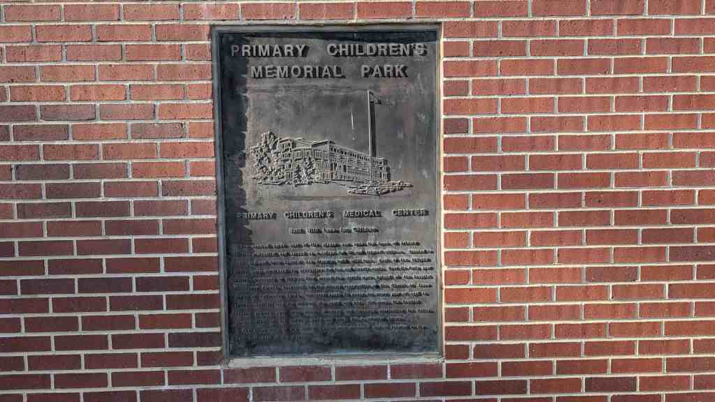
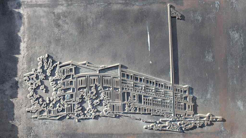
On Dec. 1, 1964, the U.S. General Services Administration transferred title of the old V.A. property to the Church of Jesus Christ of Latter-day Saints (LDS Church). The Church exchanged churchowned property valued at $763,400 and $25,000 cash for the property. The Church used part of the facility as an annex to its Primary Children’s Hospital. The buildings also housed some classes for the Church’s Brigham Young University Salt Lake Center.
The LDS Church sold the property on December, 17, 1987 to IHC Hospitals Inc., which subsumed Primary Children’s and a number of other Church owned facilities. When a new Primary Children’s Hospital was opened in April of 1990, the old V.A. Hospital was left vacant. On January 30, 1995, IHC sold the property to Park City Construction. The original 28 acres was subdivided and sold to developers, with Park City Construction retaining the 5.3 acres on which the hospital itself sits. Their intention is to retain the historic exterior as nearly as possible and remodel the interior into condominiums. The company offices are currently housed in the annex. The main building is vacant while the remodeling takes place. A small maintenance and repair shop building was part of the original hospital construction. It is located to the northeast of the hospital on a parcel now owned by the LDS Church and is scheduled for demolition.
The integrity of the Veterans Administration Hospital buildings has been maintained and they contribute to the historic qualities of the Avenues Historic District area. Current plans appear to provide for appropriate reuse of the buildings and safeguard their continued use.
Narrative Description
Constructed in 1932 and 1939, the Veterans Administration Hospital on Twelfth Avenue in Salt Lake City is a red brick neoclassical style complex that faces south. It is set back from the street on a steep hill, giving it a stately presence. The main building, constructed in 1932, has a gabled, five-and-a-half story central section with four-story cross wings extending east and west. It is attached in the rear (west side) to the smaller 1939 annex by a three-story L-shaped brick connector. There are two fairly minor exterior alterations to the main building. The wide, floor length windows on the third and fourth floor southeast and southwest corners have been bricked in, and the stairway leading to the second floor front entrance of the main building has been removed and replaced by a ground level entrance. The building retains most of its original integrity and contributes to the historic qualities of the area.
Subdued exterior classical details found on both buildings include symmetrical facades, pedimented entryways, circular windows with garland embellishments on the tympanum, keystones above the window openings, dentils, and Ionic pilasters. Twelve-over-twelve double-hung windows exist throughout the Veterans Hospital, incorporate central gable pediments. The roofs are gabled and the main building incorporated three dormers along the front. The four-story wings have flat roofs. The connector service wing has a flat roof. All roofs are asphalt.
The main building has a central corridor running the length of the building with single and double rooms and multiple-bed wards on each side. Changes include the bricking in of the large windows in the southeast and southwest corners of the third and fourth floors. Originally day porches, they were changed to rooms suitable for six-bed wards. The annex floor plan originally included large, open administrative and meeting spaces supported by pillars. These spaces have since been closed into small rooms. Some of these rooms now serve as offices for the current owner, Park City Construction. Ceilings in both buildings have been lowered. The overall integrity of the interior spaces remains good.
Just outside the present boundaries of the property to the northeast of the main hospital building is the only small outbuilding dating from the original construction period. It is a two-story brick maintenance and repair shop. Though historically part of the hospital property, it is currently part of another parcel and is scheduled for demolition.
This Classical Revival structure was built by Joseph Don Carlos Young, noted LDS Church architect, in 1921. Andrew Hansen, a local farmer and builder, supervised the construction. The cost of the chapel was $20,000. It was dedicated December 11, 1927, by LDS Apostle George Albert Smith.
The Sandy Second Ward Chapel was built during a time of emphasis on multiple-use buildings and architectural experimentation. The building combines a large chapel area, classrooms, and recreation space. The building was converted to a Baptist church in 1962 and is still being used for religious worship. It retains its historic integrity and remains in excellent condition.
Located at 8630 South 60 East in Sandy, Utah and added to the National Historic Register (#97000638) on July 9, 1997
The Sandy Second Ward Chapel, built in 1921, is being nominated under two contexts: 1) Mormon Meetinghouses and Tabernacles in Utah, 1847-1936; and (2) Historic Resources of Sandy City: Specialized Agriculture, Small Business and Community Development Period, 1906-1946. The Classical Revival structure combines a large chapel area, classrooms, and recreation space. The chapel represents the third phase of Mormon (LDS) meetinghouse building during which there was an emphasis on multiple-use buildings and architectural experimentation. The architect, Joseph Don Carlos Young, was serving as the official LDS Church architect at the time he designed this building. The chapel is of local significance as the only surviving historic LDS chapel in Sandy. The building was converted to a Baptist church in 1962 and is still being used for religious worship. The chapel retains its historic integrity and remains in excellent historic condition.
The Sandy Second Ward Chapel is located near State Street, northwest of Sandy’s historic downtown. The area was originally collection of small farms. The property was purchased from LeGrande Young by Josephine Jensen in October 1893. She sold it five months later to M.L. Freed. The taxes were not paid so it was taken over by the county until sometime before 1921 when Morinda Lundberg, a postmistress in Sandy redeemed it and donated it to the Sandy Second Ward.
At the turn of the century, the congregation of Church of Jesus Christ of Latter-day Saints (LDS or Mormon) church members had only one meetinghouse, a gothic revival style structure completed in 1897. As the town’s LDS population grew, mostly due to the number of second generation church members, it became necessary to divide the congregation. On January 1, 1921, church officials decided to create the Sandy Second and Third Wards. The First Ward continued to meet in the 1897 meetinghouse, and the Second Ward began to hold their meetings in the local school.
The Second Ward began almost immediately to build their own meetinghouse. The cost of the structure was $20,000. The architect was Joseph Don Carlos Young, LDS church architect. Local farmer and builder, Andrew Hansen supervised construction.
The chapel was dedicated December 11, 1927 by George Albert Smith. James P. Jensen was the first Bishop with counselors, A.R. Gardner and Robert Larsen. G. Leonard Ohlson was clerk. Clyde Swenson was chairman of the building committee. The first bishopric served sixteen years.
As an LDS meetinghouse, the building saw little modification. On December 17, 1924, an electrical fire reportedly caused $1,000 damage to the chapel. 19 Additional lots with residences were acquired in 1950. The residences were perhaps used by the Second Ward for additional meeting space. Within a decade, the building was considered inadequate for the growing congregation. A new building was constructed large enough to house both the First, the Second and the 13th Wards, and was officially dedicated on March 27, 1966.
The building and grounds of the old Second Ward Chapel were deeded to the Anchor Baptist Church on May 7, 1962. The Anchor Baptist Church used for six years, during which time, they were constructing a new building on 5600 South near Highland Drive. They could not handle the financial obligations of both buildings. On May 17, 1968, the property was deeded to the Baptist Mid Missions Inc., and a congregation of Berean Baptists currently uses the building.
Architecture:
The Neoclassical, or Classical Revival, style enjoyed many years of popularity in Utah and the rest of the United States. Between 1900-1925, buildings such as banks, courthouses, post offices and churches employed the Greek and Roman classical motifs.
More conservative than the contemporary Beaux Arts Classicism, neoclassical buildings were usually symmetrical, monumental forms with facades highlighted by colonnades and porticos. The Sandy Second Ward Chapel is a relatively simple version of the style, but the building includes several distinguishing elements: the raised basement, the Tuscan columns at the entry, the arched windows, the parapet and the accentuated keystones. 22 The chapel is a unique interpretation of the style with an asymmetrical curving façade (which pre-dates the Art Moderne movement by nearly a decade).
Architect:
Joseph Don Carlos Young was born on May 6, 1855. He was the son of Brigham Young and Emily Dow Partridge Young, and was one of the first native Utahns to be formally educated in architecture. He attended the Rensselear Polytechnic Institute in New York. Joseph Don Carlos Young designed a number of commercial and residential buildings in Salt Lake City, but is primarily remembered as one of the official architects of the LDS Church (c. 1883-1930). He directed the completion of the interior of the Salt Lake Temple and designed the LDS Church Office Building (now known as the administration building). He took a part in designing several LDS Chapels. Young utilized a variety of styles, but primarily designed Neo-Classical and Renaissance Revival buildings. The Sandy Second Ward Chapel represents a relatively simple and refined statement of his work. Joseph Don Carlos Young died in 1938.
Narrative Description:
The Sandy Second Ward Chapel, built in 1921, is located at the corner of 8640 South and 60 East in Sandy City. The current address of the building is 8630 South 60 East. The building is located on the southeast corner of a 0.77 acre property. Two residences are also on the property, but do not contribute to the historic significance of the chapel. The building has received only minor exterior and interior alterations since its original construction.
The building is constructed of dark maroon brick on a concrete foundation. In plan, the structure is L-shaped, with the longer end, approximately 90 feet, running parallel to 8640 South. The shorter end is approximately 45 feet and is parallel to 60 East. The main entrance is at the curved intersection of the two sides, and is accessed by ten curvilinear concrete steps. The exterior brick walls rise from a plastered concrete foundation and water table to a parapet which runs along the street facades of the building. The parapet hides the two intersecting gables of the asphalt-shingled roof.
The parapet is capped by a coping of rowlock brick. Two feet below the parapet is a metal cornice. A rowlock course of brick is found directly belong the cornice. A second cornice extends over the main entrance and is supported by four columns. The visual line of this cornice is continued around the building by a course of soldier brick. Three courses of brick, one header and two stretcher, are “punched out” and circle the building at the window arches.
The building elevation is divided into bays by thirteen large round arched windows. The window arches are of rowlock brick and accented by lug sills, impost blocks, and keystones made of a cast aggregate resembling granite. The original windows had sixteen panes and hinged at the bottom to open inward. The semi-circular windows were “spoked” with wooden muntins. The windows were replaced in the 1980s by one-over-one fixed windows and the arches have been filled in with vinyl lap siding. The main entrance was originally two doors under an elliptical arch, also accented with a keystone and impost blocks. They have been replaced by a single door with sidelights. The fanlight over the doors was replaced by a single sheet of glass in 1980s, but has been more recently covered by plywood.
The most prominent Classical elements on the building are the four columns at the main entrance (two of which are currently hidden by a pair of large evergreens). The columns are made of the same granite-like cast aggregate and are Tuscan with a slight entassis. The only other decorative elements are two signs which read “Berean Baptist Church”. One is above the main door and the other is on the otherwise blank west wall under an elliptical arch. According to the Pastor Wesley Clem, the original stained glass window in that space was removed (date unknown).
Another blocked window is also on the west side at basement level. The other basement windows are used, though the glass and frames have been replaced. Two exterior doors, one on 8640 South and the other at the rear, access the basement level.
The main floor of the building is above a raised basement and has three sections: foyer, classrooms and chapel space. The main entrance originally opened to a wedge-shaped vestibule and a foyer with a high ceiling. The vestibule was partitioned to make closet space and a pair of windowed doors was installed at the foyer entrance in 1995. Access to the chapel from the foyer is through a pair of doors to the west. At the south is a staircase with one landing to the lower level, while on the east wall is a door leading to a small office. On the north side of the foyer are two doors leading to classrooms. Some type of door, possibly a folding door, originally allowed the rooms to be made one large room, but the opening has been blocked. One corner of each room has been converted to a closet.
Entrance to the chapel from the foyer was through a large, arched opening now enclosed by two doors, installed in the 1980s. The chapel floor slopes two feet from the back to the front of the chapel. The space of the chapel has changed little since the original construction, although a major remodeling of the pulpit area took place when the Baptist congregation modified the chapel for their worship services in the 1960s. The original pews were removed and replaced by others in the 1980s. Drywall has been applied to the interior walls of the chapel and the windows no longer appeared arched from the inside. The drywall also covers a row of stenciling which decorated the chapel. The ceiling has been sprayed with asbestos and the lighting fixtures have been updated. Insulation materials were added to the majority of the main floor rooms at the same time the drywall was applied during the 1980s.
A second arch spans the podium area. The original molding and a plaster dove in relief at the center of the arch are still intact. The arched opening was originally flanked by dark wood Tuscan columns and a pair of heavy curtains. The columns have been removed and the sides enclosed as dressing rooms for the baptismal font. An original staircase down to the basement level is now accessed from the south dressing room. Another staircase leads to the rim of the baptismal font. The font area was constructed in 1969. Previous to that date, the building had no font. The baptismal font was built at the back of the podium and can be partially viewed by the congregation through a arched opening. The back of the font, as well as the floor and walls of the dressing rooms, is tiled in squares of beige.
Above the font is a Latin cross tiled in a slightly darker color. The ceiling above the font has a latticework screen which is original.
The basement runs the full length of the building. The balustrades of both staircases are original, as are the doors and much of their hardware. There was originally one restroom, with a dirt floor, at the east end of the basement. The room was enlarged by excavation and made into two restrooms. Under the foyer area are two classrooms and two closets, all finished in drywall. Similar work is in progress in the classrooms and hallway under the chapel. A large room, probably recreational space, is at the west end. This space originally could be enlarged by some type of folding door leading to the classrooms, now blocked as well.
The ceiling of the basement was originally sloped to match the floor above. A drop ceiling is currently being installed to give a space a uniform ceiling height. Under the podium and font are storage rooms.
The building occupies the southeast corner of a 0.77 acre property. Associated with the building currently, but not during the historic period, are two residences at the northwest corner. The front building (8595 South 40 East) is a 1950s cottage used as housing for the Berean Baptist missionaries. The back building (8597 South 40 East) is reportedly from the 1880s and is currently the home of the associate pastor. This building has been altered substantially. Both are white with lap siding.
There are two small aluminum sheds next to the back residence. A large gravel parking area adjoins the houses. The rest of the property is landscaped with grass. An irrigation ditch runs along the north side of the site. A smaller, disused ditch is on the east. Sidewalks are found on the south and west sides. Four large evergreens flank the entrance. A row of poplars has recently been planted along the east side of the site.
Historic Context: Mormon Meetinghouses and Tabernacles in Utah, 1847-1936
The history of Utah is closely tied to the Church of Jesus Christ of Latter-day Saints. More commonly known as Mormons, members of the church played a significant role in the early settlement and subsequent growth of the state of Utah. It is not surprising therefore that the religious buildings of the Mormons comprise one of the principal segments of the state’s architectural heritage. Within the larger theme of Mormon religious architecture, eight specific historic contexts have been identified [See the Multiple Property Submission, Mormon Church Buildings in Utah. 1847-1936]. The Sandy Second Ward Chapel is significant within the third phase of the context “Mormon Meetinghouses and Tabernacles, 1847-1936”.
The most common types of nineteenth-century Mormon religious buildings were the meetinghouses and tabernacles. Designed as assembly halls for regular Sunday services, these buildings differed principally in size and scale. Tabernacles were typically large buildings with a seating capacity sufficient to accommodate the membership of several LDS wards, with wards being the smallest unit of ecclesiastical jurisdiction within the LDS Church. Smaller Mormon towns consisted of a single ward, while the larger communities were subdivided into several such districts. Every ward had a meetinghouse, or ward meetinghouse. Wards were further organized into larger geographical groupings called stakes, and usually (though not always (each stake had its own tabernacle. Tabernacles and meetinghouses were generally placed in a central location within the gridiron plan of the Mormon town. There are approximately 20 tabernacles and 237 meetinghouses remaining in Utah that were constructed prior to 1940.
Tabernacle and meetinghouse design went through five significant periods of historical development. The first period is associated with the early years of Mormon western settlement and begins with the arrival of the Saints in the Great Salt Lake Valley in 1847 and extends until around 1870. During this phase, the smaller meetinghouses were likely to serve a variety of functions such as schoolhouses, city halls, and social centers.
A second period of LDS Church tabernacle and meetinghouse architecture was ushered in by the ecclesiastical reforms of the late 1870s. A significant number of new religious buildings appeared throughout the state during the years between 1870 and about 1885. These buildings were generally larger and more substantial than those of the settlement period. At this time also it became characteristic of Mormon communities to have separate buildings for different functions. Another result of this increased building activity was that many of the first-period structures were demolished to make way for the new ones.
The expansion activities of the LDS Church were curtailed during the 1880s and 1890s as the leadership’s attention was increasingly consumed by the struggle with the U.S. Government over the doctrine of polygamy. Under pressure from Congress, The Mormons disavowed the practice of plural marriage in 1890 and the way was paved for Utah to become a state in 1896. Nearly twenty years of political conflict, however, had left the church in confusion and disarray. Beginning in about 1898, a serious revitalization program was launched that included, among other things, a restructuring of the hierarchy, a return to financial solvency, a revival of faith and commitment among the membership, and a rebuilding of the church architecture.
As a symbol of rededication, a massive church building effort was initiated in 1898 that lasted until the end of World War I and into the 1920s. This period of architectural development may be considered one of “activation”, as the church moved to strengthen its institutional base in Utah and surrounding states. It was during this time that the first “modern” meetinghouses appeared. These multi-functional buildings gathered all the activities of the local church under one roof. Ward buildings now included an assembly hall or chapel, the offices of the bishop, a room for the women’s auxiliary, and classrooms for Sunday school. Designs varied. On one side, a conservation faction within the church hierarchy favored the Neoclassical and Colonial Revival, while on the other, progressive groups championed Prairie School and Arts and Crafts designs. All in all, the early years of the twentieth century mark one of the richest periods in LDS Church architectural history.
The fourth period in tabernacle and meetinghouse development spans roughly a thirty-year period between 1925 and 1955 and represents a time of both consolidation and experimentation. The multi functional building became the mainstay of the building program, but designs ranged from the Moderne to the Colonial Revival. The LDS Church grew rapidly during the 1940s and 1950s and the need for new meetinghouse construction was even greater. Standardization increased, and there was a drive toward architectural efficiency that eventually lead to the creation of the LDS Church Building Department in 1954. The work of building department architects remains the final and fifth stage in the development of Mormon religious architecture in Utah.
The Sandy Second Ward Chapel is significant within the third phase of meetinghouse development. There are currently 29 meetinghouse buildings remaining in Utah from the third phase. The construction dates of these buildings ranged from 1899 to 1925. Sandy Second Ward Chapel represents the multi-functional and architecturally rich meetinghouse of the third phase, but it was also designed by an official church architect, a practice which would become more common in the fourth phase. The building was used by the LDS Church until the 1960s when it was replaced by a non-historic chapel.
The remaining Period III meetinghouses are as follows:
American Fork Second Ward Meetinghouse, Utah County (Historic District)
American Fork LDS Third Ward, Utah County
Clearfield Ward Chapel, David County
Clinton Ward Meetinghouse, Davis County
Enterprise Meetinghouse, Washington County (National Register listed)
Eureka LDS Wardhouse, Juab County (Eureka Historic District)
Hanksville Meetinghouse School, Wayne County (National Register listed)
Heber First Ward Meetinghouse, Wasatch County (major addition)
Heber Second Ward Meetinghouse, Wasatch County (National Register listed)
Hyrum First Ward Meetinghouse, Cache County (National Register listed)
Kaysville Tabernacle, Davis County (State Register)
Leamington LDS Church, Millard County
Levan Ward Chapel and Amusement Hall, Juab County
Logan Sixth Ward, Cache County (Logan Historic District)
Moab LDS Meetinghouse, Grand County (altered)
Moab Star Hall, Grand County (National Register listed)
Murray First Ward, Salt Lake County (NR documentation started)
Murray Second Ward Meetinghouse, Salt Lake County
Murray Tenth Ward (formerly Grant Ward House), Salt Lake County
Prove Third Ward Chapel and Amusement Hall, Utah County (National Register)
SLC 453 S 1100 E, Salt Lake County (University Historic District)
SLC 160 S University, Salt Lake County (University Historic District)
SLC Cannon Ward LDS Church, Salt Lake County
SLC Fifth Ward Meetinghouse, Salt Lake County (National Register listed)
SLC Ensign Ward Meetinghouse/Amusement Hall, Salt Lake County (Avenues H.D.)
SLC Guadalupe Center (LDS 16th Ward), Salt Lake County
SLC Miracle Rock Church (LDS 34th Ward), Salt Lake County
SLC New Hope Center, Salt Lake County
Sandy Second Ward Chapel, Salt Lake County (NR documentation started)
History of Sandy:
The first half of the twentieth century was a period of transition for the city of Sandy. The mining, smelting and small farm era was being replaced by a more diversified economy. In some ways the town still resembled the earlier predominantly agricultural community founded by Mormon settlers in the 1860s, especially as the “boom town” economy created around the mining industry waned. The population of Sandy remained around 1,500 for the four decades between 1900 and 1940. However, the city was defining itself as the political, economic, civic and social center for a major portion of the southeast Salt Lake Valley. This period of Sandy’s history laid the groundwork for city’s eventual transformation from small town to suburb.
The transition began with the failure of several canyon mines which fed Sandy’s economy. As sampling and smelting plants shifted to other locations, Sandy’s impact as a mining town diminished.
While the dominant force in the economy of Sandy during the 1870s, 1880s and 1890s was undoubtedly that of mining, the local agricultural community had not ceased to develop. The local agricultural economy saw Sandy through the mining boom and subsequent depression.
The community was also seeing a great deal of civic development. The city of Sandy was incorporated on September 26, 1893. By 1911 the city was managing its own water resources and had a volunteer fire brigade of twenty-five, complete with two fire trucks. Utah Power and Light began servicing Sandy in 1913, and by 1914 the city was managing a park and a cemetery.
Economically, the city was changing dramatically. The depletion of the mineral resources in the Alta area and the loss of the smelting and sampling industries had changed the economic structure of Sandy City significantly. Moreover, a series of national and local depressions beginning in 1893 and continuing to the onset of World War II had made small-scale single-crop agricultural enterprises nearly impossible. Sandy farmers had an especially difficult time, needing to overcome the additional challenges of water scarcity and the arid, sandy soil.
Fortunately irrigation methods improved steadily through these years, and several Sandy farmers were able to successfully continue to raise hay and grain. Despite the success of these specialized agricultural industries, most farming in Sandy during the first half of the twentieth century was purely subsistence level. Between 1900-1920, the number of farms doubled, but nearly all were very small scale. Eighty-five percent of the farms were smaller than forty-nine acres. Six farms were between two hundred and one-thousand acres, and one farm was 1,217 acres.
During the first half of the twentieth century, the majority of Sandy residents continued to live on their farms. Most managed to survive economically by combining subsistence farming with other occupations, primarily cottage industries and mercantilism. The majority of occupations were highly diversified. Sandy appeared to have at least one resident involved in occupations associated with early urbanization: a physician, a dentist, a barber, a plumber etc. The most common business listed was dry goods. The Sandy City Bank founded in 1907, employed four, and had the largest deposits of any bank in the southern portion of the Salt Lake valley. Several residents listed their civic responsibilities: city treasurer, postmaster, marshal, justice of the peace.
As the non-Mormon or “Gentile” population moved out of Sandy with the decline of the mining industry, Mormonism continued to be the dominant religion. By the 1920s, the LDS population had grown large enough to require the construction of two new ward buildings. The Sandy Second Ward meetinghouse was completed in 1921 and the Third Ward in 1926. In addition to the three LDS wards, the 1927-28 gazetteer lists two other congregations: the Sandy Congregational Church and the Inter-Mission (Swedish/Lutheran) Church.
Before the 1900s, transportation between Sandy and other towns in Salt Lake County had been limited to pedestrian or horse traffic on rutted, dirt roads. Several railroad lines and mining related spurs had converged at Sandy by the 1880s, but the service they performed was primarily freight. The extension of the State Street streetcar line from Murray to Sandy on July 4, 1907 gave Sandy residents easier access to the shops and recreations of Salt Lake City.
A few residents may have commuted to work in Salt Lake, but the city generally remained self-contained. Buses began to replaced streetcars in the 1920s, at about the same time State Street’s south end was paved for automobile traffic. The last streetcar to operated in the Salt Lake Valley was discontinued in the 1946. By that time, automobiles were becoming increasingly more common, even in Sandy.
The original township of Sandy had expanded to the west of the railroad tracks with the boom of the mining industry. After the turn of the century growth was slower. At the west boundary of the city, commercial buildings as well as bungalows and period cottages appeared along State Street, the main artery to Salt Lake City. The institutional buildings, both civic and religious, were also made of brick and exhibited a variety of popular styles and decorative elements. Of the remaining large commercial and institutional buildings, examples ranged from the Renaissance Revival to PWA Moderne.
The Specialized Agriculture, Small Business, and Community Development Period in Sandy was a time of transition from farmlands and mining industries to quiet neighborhoods and small town civic pride. The architecture of the historic square mile of Sandy, as it is called, illustrates this transition, and stands in marked contrast to later development. In the years since World War II, Sandy has plated nearly 300 subdivisions and annexed over 10,000 acres, making it one of Salt Lake’s largest “bedroom” communities. Though Sandy’s city center has been moved adjacent to the mall, the city’s historic downtown is a distinctive reminder of Sandy’s small town past.
The first known residents of the Riverton area were the Yo No Indians, a poor tribe living along the Jordan River. Well-worn trails extended from Utah Lake where various tribes wintered, to Bear Lake where they rendezvoused during the summer. Much credit is due for the free use of their byways, exchange of leather goods and furs, relinquishing land, and their general friendly attitude. Four forts erected west of the river were never seriously needed for protection. They were: Wight’s Fort, north by the Oquirrh Mountains; English Fort at the Bennion Cemetery site; Fort Herriman, 5 miles west of here; and Cedar Fort to the south.
Riverton was born of the Pioneer Spirit that moved men and women independently to reach out and wrestle a living from the harsh, untamed land. Many settlers spent their first year in dug-outs along the Jordan River as did the Yo No’s.
In 1855, Abraham Hunsaker, a convert from Illinois and a member of the Mormon Battalion, moved his herds across the river to join Jesse Beckstead and Samuel and Thomas Butterfield who were already using the land for grazing. Abraham was the first man to own land and divert water. But Archibald Gardner was the first to live here and become the largest land owner; so for many years the area was called “Gardnersville.” Judge Charles Smith later named the town “Riverton”.
From 1850 to 1881 most attempts to bring water to the land were inadequate, however, some succeeded. The fertile soil responded, and the permanent expanding settlement was here to stay. Sheep, cattle, alfalfa, beets, minerals, poultry, and dry farming all had their “hey day” and contributed greatly to the growing economy.
A maturity milestone was reached August 8, 1886, when the Riverton Ward of the Church of Jesus Christ of Latter-day Saints was organized with 138 members. Orrin P. Miller served as the first Bishop. Plans were soon underway for a new meeting house. Richard W. Kletting was selected as architect. (He was also architect of the Utah State Capitol and the old Saltair Pavillion). Willard C. Burgon was named building contractor. With visions of new hope, the people geared for Riverton’s “Grandest Effort.” Construction began in 1899.
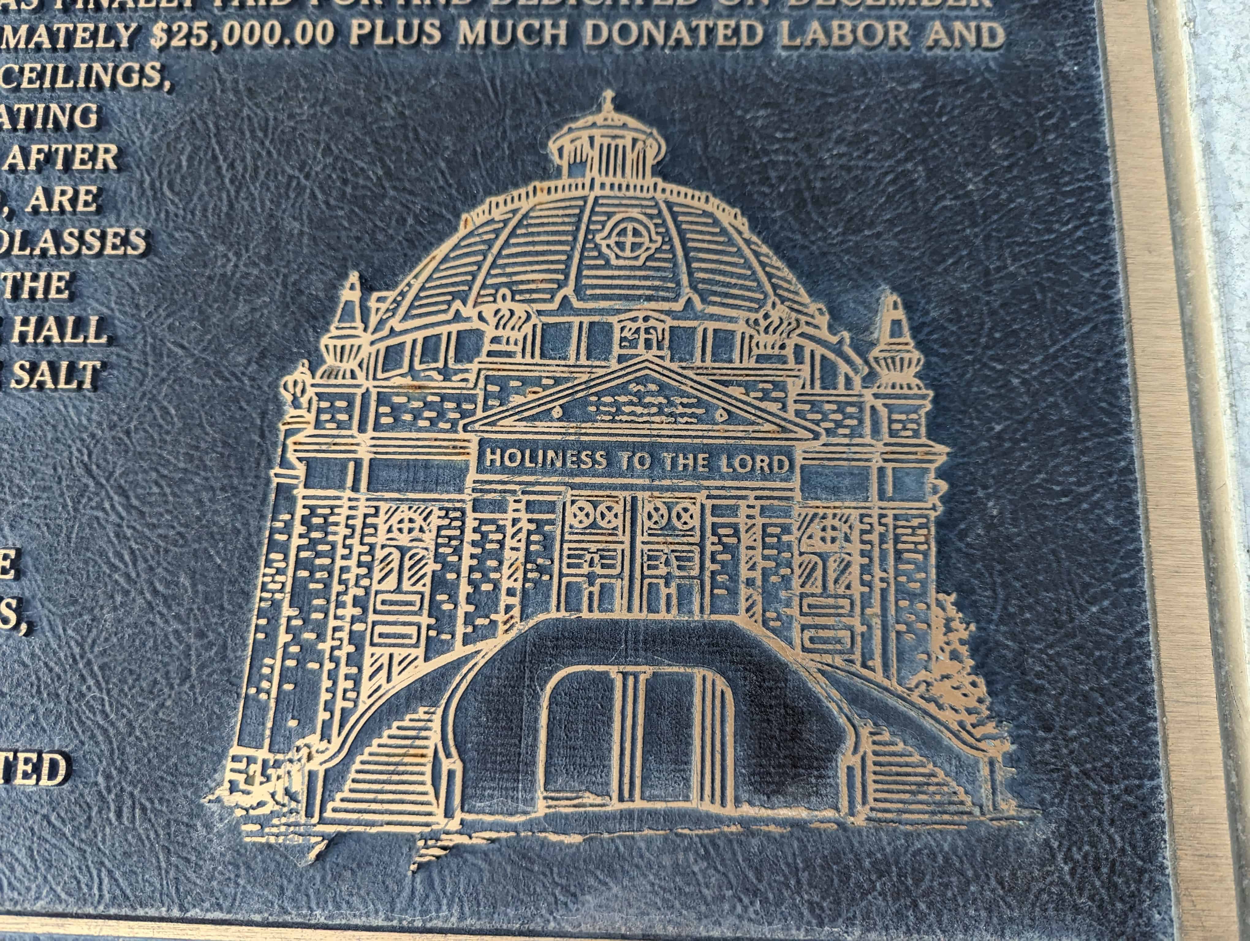
This magnificently beautiful domed church, with the inscription “HOLINESS TO THE LORD” over the front door was erected at 12800 South Redwood Road on a two-acre site donated by Thomas P. Page. With its high dome, it was an inspiring edifice and could be seen for long distances.
On January 21, 1900, Bishop Miller was sustained stake president, Gordon S. Bills was ordained bishop of the 346 member ward. The lower part of the building was in use by 1908. There were many financial hardships during construction, however, it was finally paid for and dedicated on December 20, 1920. The cost was approximately $25,000.00 plus much donated labor and materials. Because of its high ceilings, excessive maintenance and heating problems, it was razed in 1940 after just 30 years of use. Gone, too, are the brick kiln, Tithing Yard, molasses mill, flour mill, harness shop, the Commercial Building and dance hall built by Daniel Densley, and the Salt Lake and Utah Railroad (Orem Commuter Line) 1914-1945.
Many fond memories linger in the hearts of the long-time residents, the “Pioneers” of Riverton.
This monument is gratefully erected to their memory and integrity.