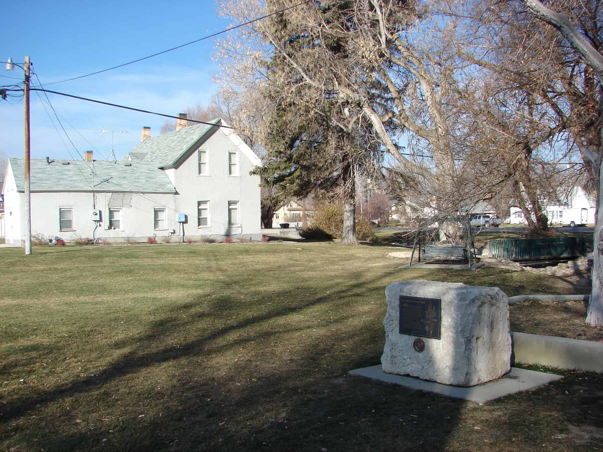
Three Mile Creek, later named Perry, originated in 1853 with the arrival in the Three Mile Creek Valley of the William Plummer Tippetts family and Lorenzo and May Perry.
They were soon joined by William Walker, Thomas C. Young, Alex Perry, and Robert Henderson and their families. Earlier the land had been claimed by Orrin Porter Rockwell and was an important camp site for Indians and pioneers passing through.
Ashael Thorne and Hyrum Tippetts built a saw mill at the mouth of the canyon in 1860. Other mills in the area were a shingle mill and a molasses mill. A cooperative store was founded in 1865 with Henry Perry president. The Union Pacific Railroad was built here in 1869.
Elizabeth Osborne was the first recorded teacher; school was held in her home. The first school building was built of logs in 1863. Here all community meetings and dances were held.
The Three Mile Creek Branch of the Church of Jesus Christ of Latter-day Saints was established in 1854, with Gustavus Adolphus Perry as Presiding Elder. The Three Mile Creek Ward was organized August 19, 1877, with Orrin Alonzo Perry as Bishop and his wife Jane as Relief Society President. In 1898 the name of the settlement was officially changed to Perry in honor of Bishop Perry.
Located at 2419 South Elm Grove Drive in Perry, Utah.
A tithing barn was built on this property in the summer of 1885, two years after the first settlers arrived in Rexburg. The barn was built of 1×10 inch rough lumber and put together with wooden pegs. It was sixty feet long and thirty feet wide. The lower floor housed grain, animals, and produce, while the loft held hay. As the Pioneer Saints in this area had very little money, they paid tithes with produce which was stored in the barn and disbursed as needed.
There were no homes available in 1888 when Jacob Spori came to Rexburg to be the first head of the Bannock Academy (Ricks College). He and his family were housed temporarily in the empty tithing bar. On July 6, 1888, Elizabeth Spori Stowell was born in one of the grain bins that had been converted into a temporary bedroom.
In 1899 the tithing barn was sold to John A. Garner, one of the original settlers. It was taken apart and moved one-half mile east to 657 North Hill Road where it was reassembled and used. It is standing there today (1988).
A tithing offer was built near the barn. Later it was sold and converted into a home. In 1919 the building was razed so the Adams School could be built on the property. The First Ward Church, a rock building, was built on this block in 1905. In 1976 the rock church was severely damaged in the Teton Dam flood and replaced with a new building at a new location.
Curlew Valley, named after the curlew snipe that nests here, extends from Snowville, Utah, to the Idaho towns of Stone and Holbrook. The first recorded white men were Peter Skene Ogden‘s large party of trappers, who camped on Deep Creek December 27, 1828.
Some of the discharged members of the Mormon Battalion, on their way from California to Salt Lake City on September 18, 1848, camped on Deep Creek and also in a cave one mile east called Hollow Rock.
The beginning of Deep Creek is a large spring at Holbrook which runs through the center of the valley and has never varied even in dry years. About one mile southwest is Rocky Ford, where the pioneers were able to cross on solid rock. In 1869 William Robbins, Thomas Showell, and William M. Harris settled at the Curlew Sinks, ten miles west of here, where Deep Creek sinks into the ground. The old pioneer trail and the stage line went through their ranch.
The first townsite in Curlew Valley was Snowville, named in honor of President Lorenzo Snow, and laid out August 14, 1876.
When Joseph Harker crossed Jordan River at 3300 South in 1848, he luckily found springs. By 1870 pioneers had sparsely settled the Granger area. School was held in homes until 1882 when the 16 x 24 foot West Granger School was built at 3500 South and 4000 West on property donated by Andrew Mathews. Miss Moore was the first teacher. Next, the Dewey School was built one-half mile west of Redwood Road on 3500 South. Students paid tuition and furnished own transportation. Many pioneers had packed books into every crevice of their wagons to be shared later. In 1893, the Monroe School, a two story brick building was erected, using a part of the West Granger School foundation. Each floor was heated by a potbelly stove. This loved old building was torn down in 1924. A three-story building had been built in 1903 beside the first Monroe School and was remodeled three times. It was demolished in 1972. A third Monroe School was built at 3100 South and 4400 West. A Chevrolet complex has replaced the old school.
Check out all of the historic markers placed by the Daughters of Utah Pioneers at JacobBarlow.com/dup
In 1860’s “Tim” B. Malan found a mountain basin containing a spring and timber. By 1868, he was selling logs, using his roller invention to get them safely down the cliff. July 1892, Tim and sons finished making a road with pick and shovel; later hewed a switch-back road, built a home and hotel. Guests came in spring wagons to enjoy Aunt Loui’s cooking, play various games or watch activities in town through a powerful telescope. Malan Heights is seen southeast of this marker.
Check out all of the historic markers placed by the Daughters of Utah Pioneers at JacobBarlow.com/dup
The Indian War years of 1865-72 brought bitter hardships to Sanpete and other central Utah areas. Different bands of Indians stealthily attacked settlers from their mountain hideouts, then fled to safety. Twenty-seven settlements were evacuated; two entire counties and portions of seven others were temporarily abandoned; seventy pioneers were slain and many wounded; hundreds of cattle and horses stolen. On Aug. 1, 1866, U.S. Indian Supt., Col. H.F. Head and Stake Pres. Orson Hyde obtained promise of peace from Chief Black Hawk. By Aug. 18, 1868, they had accomplished the hazardous feat of assembling a peace parley in Fort Ephraim on Hans Hansen’s lawn by a red cedar tree. Black Hawk calmed the defiant braves, a pipe of peace was passed, the treaty was signed and later ratified by U.S. Pres. Andrew Johnson. Black Hawk continued to help arrange peace parleys until other hostile chiefs had signed.
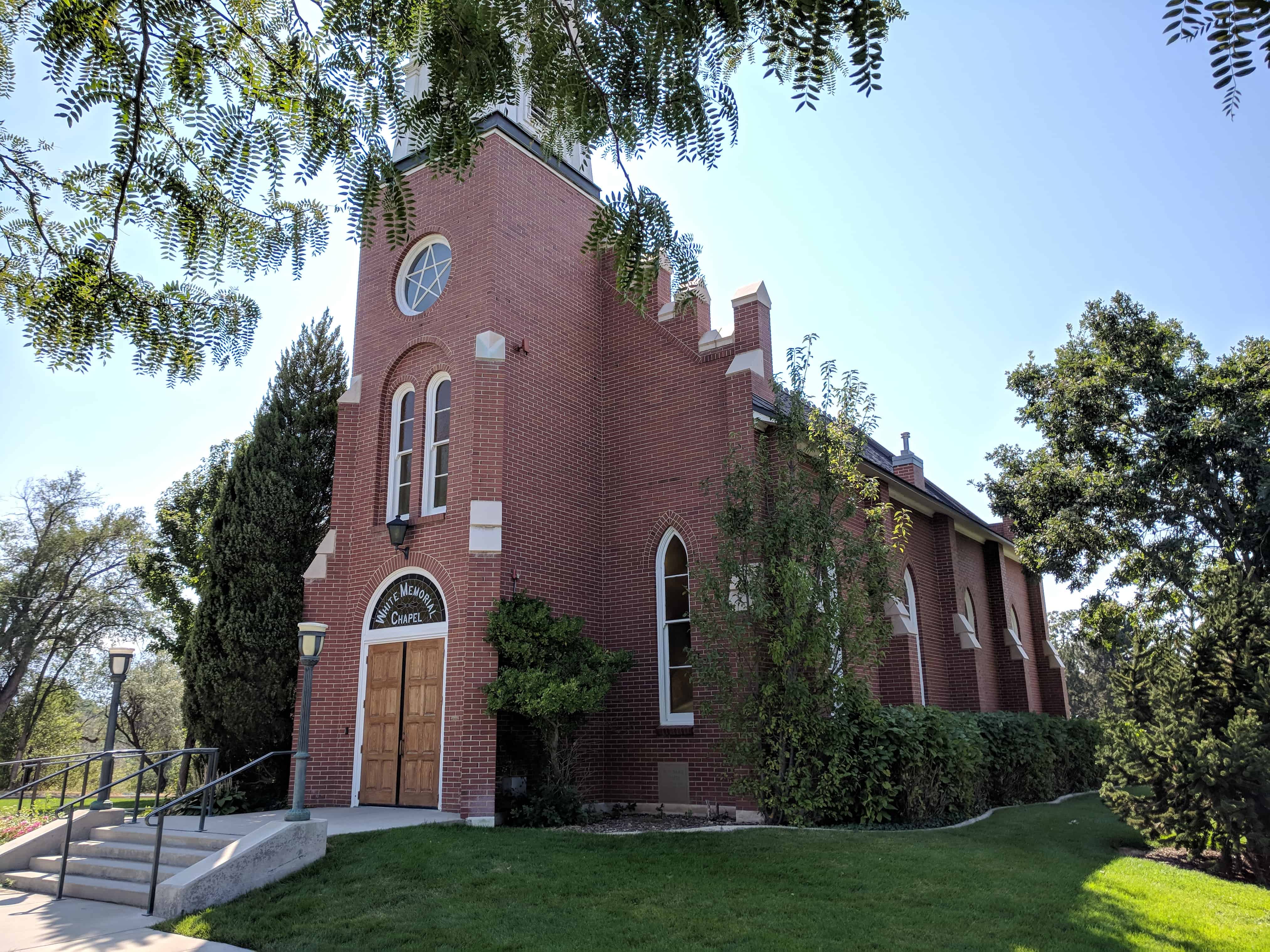
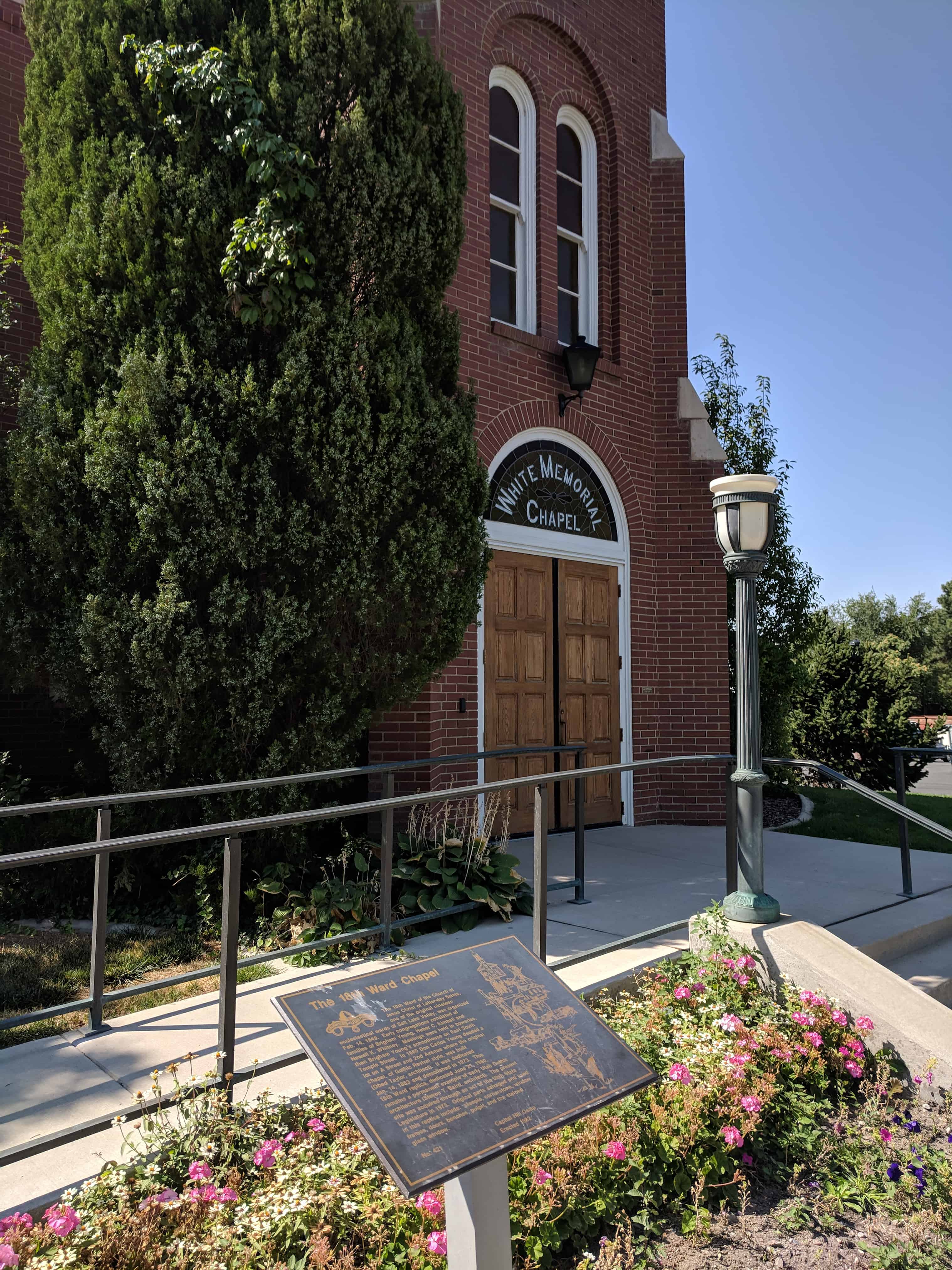
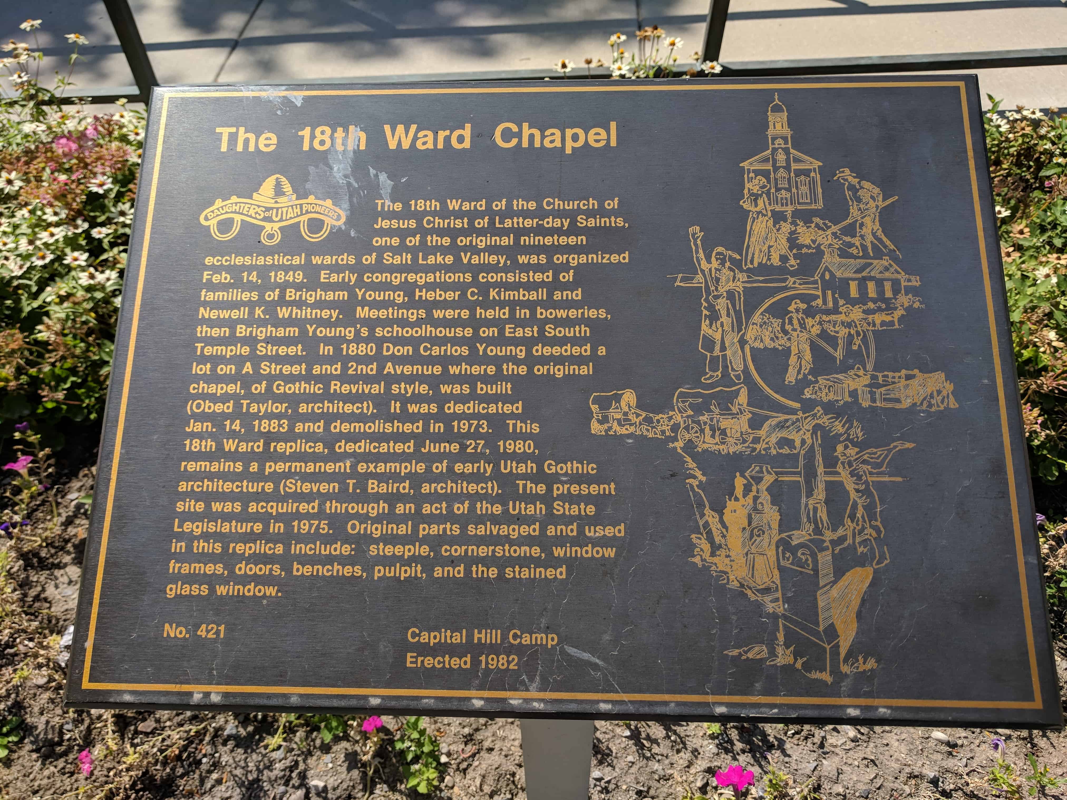
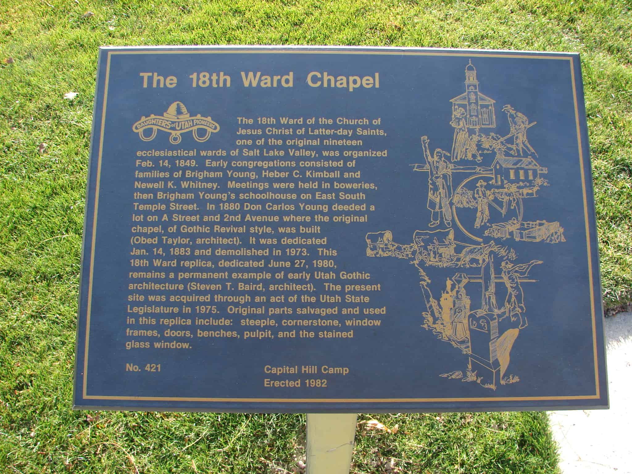
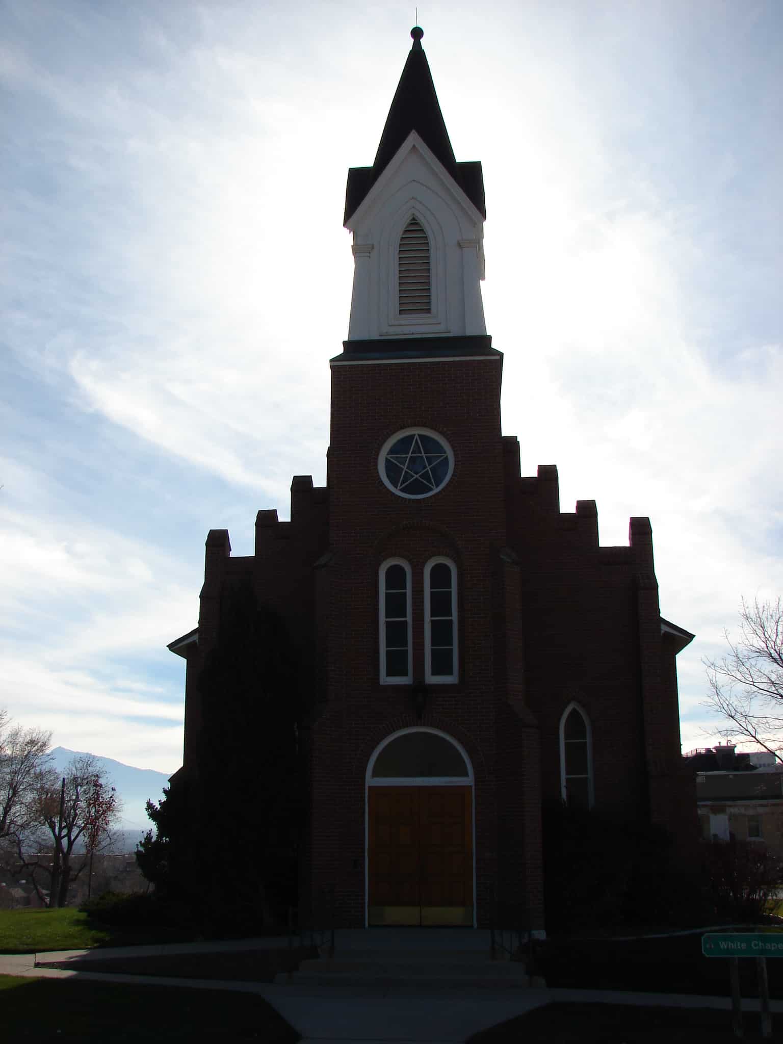
The 18th Ward of the Church of Jesus Christ of Latter-day Saints, one of the original 19 ecclesiastical wards of Salt Lake Valley, was organized Feb. 14, 1849. Early congregations consisted of families of Brigham Young, Heber C. Kimball and Newell K. Whitney. Meetings were held in boweries, then Brigham Young’s schoolhouse on East South Temple Street. In 1880 Don Carlos Young deeded a lot on A Street and 2nd Avenue where the original chapel, of Gothic Revival style, was built (Obed Taylor, architect) dedicated Jan. 14, 1883 demolished in 1973. This 18th Ward replica, dedicated June 27, 1980, remains a permanent example of early Utah Gothic architecture (Steven T. Baird, architect). The present site was acquired through an act of the Utah State Legislature in 1975. Original parts salvaged and used in the replica: steeple, cornerstone, window frames, doors, benches, pulpit, and the stained glass window.
On the north by 7th Ave. (or Ensign Ward), east by C St. (or the 20th Ward), south by South Temple St. (or the 12th-13th Ward), and west by Main St. (or the 17th Ward).
History timeline:
1849 – one of the original nineteen wards into which Salt Lake City was divided in February, 1849. At the time of its organization the ward extended northward and eastward to the mountains The first permanent settlers in the 18th Ward were Pres. Brigham Young and Elders Heber C. Kimball and Newel K. Whitney who, with their families, were the only residents of the ward for several years. 1856 – all that part of the 18th Ward lying east of Walnut St. (later A St.) was organized as the 20th Ward 1877 – boundary line was changed to Pine St. (C St.), its present boundary. 1904 – 18th Ward belonged to Salt Lake Stake, but when Salt Lake City was divided into four stakes in 1904, the ward became a part of Ensign Stake 1913 – The organization of Ensign Ward in 1913 diminished its northern boundary to 7th Ave.
The 18th ward is one of the original 19 wards in Salt Lake City in 1849, you can see the others on this page.
This is a gable roofed, gable facade chapel. The entrance pavilion has a frame cupola. There are buttresses between pointed arched windows. The building is symmetrically arranged with the roof cresting on the main gable. – D. Diana Johnson
The Eighteenth Ward was one of the original ecclesiastical divisions of Salt Lake City, for a few years inhabited only by President Brigham Young and Elders Heber C. Kimball and Newell K. Whitney. “In 1883 a fine brick chapel, erected by the Saints on A Street between 2nd and 3rd Avenues, was dedicated.” This structure was demolished about 1975 and a reconstruction, incorporating elements of the original building, was completed in 1979.
Homesteaders and settlers came in the 1870’s to the area 4700 South to 7200 West, north to the Great Salt Lake, northeast along it’s shore and the Davis County line to 4800 West and south to 4700 South. This area became Hunter Precinct in 1880 from the east part of Pleasant Green, and was named in honor of presiding Bishop Edward Hunter. The northern soil was too alkaline to farm. In 1881 the Utah Salt Lake Canal brought water to the central part. a 20′ x 30′ adobe chapel was erected in 1885 for religious meetings, 50th District School, and community activities. Hunter Branch became a ward in 1888. East of this site the 50th District School was built in 1891. The name was changed to Hunter School in 1906 and Whittier in 1908.
– – – – – –
The marker is located on the south face of a brick fence pillar along the fence line between Hunter Park and the LDS Hunter Chapel at 3665 S 6000 West. The pillar is the second pillar from the street and the fence is directly in line with Brook Hollow Drive where it intersects 6000 West.
Check out all of the historic markers placed by the Daughters of Utah Pioneers at JacobBarlow.com/dup
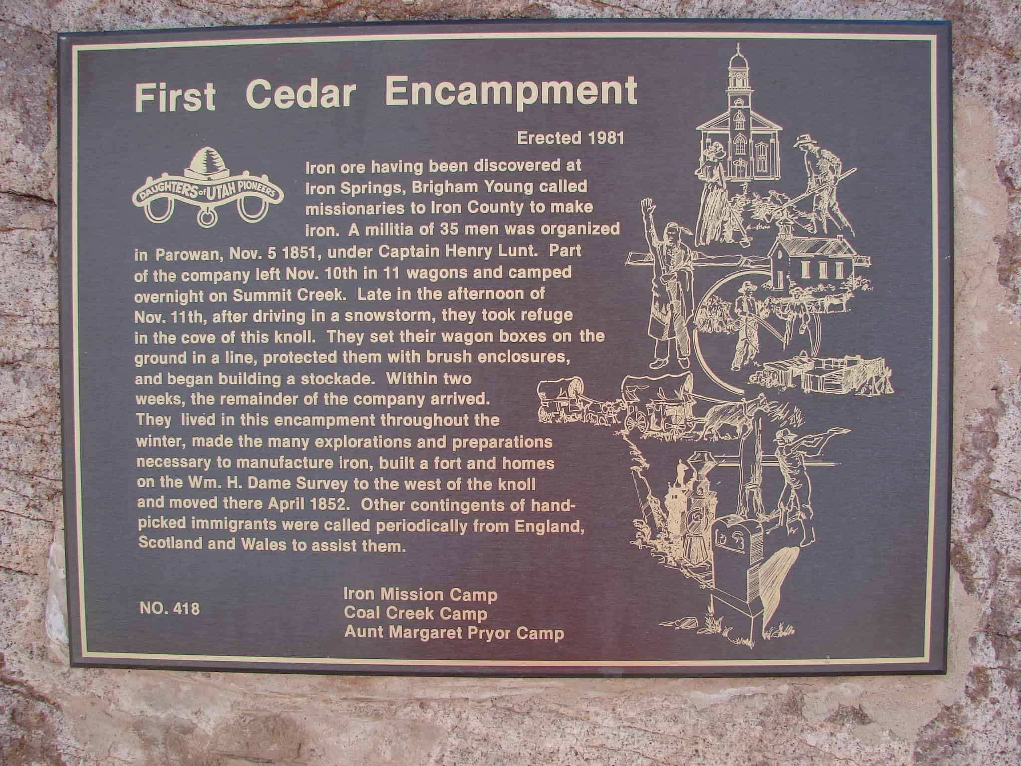
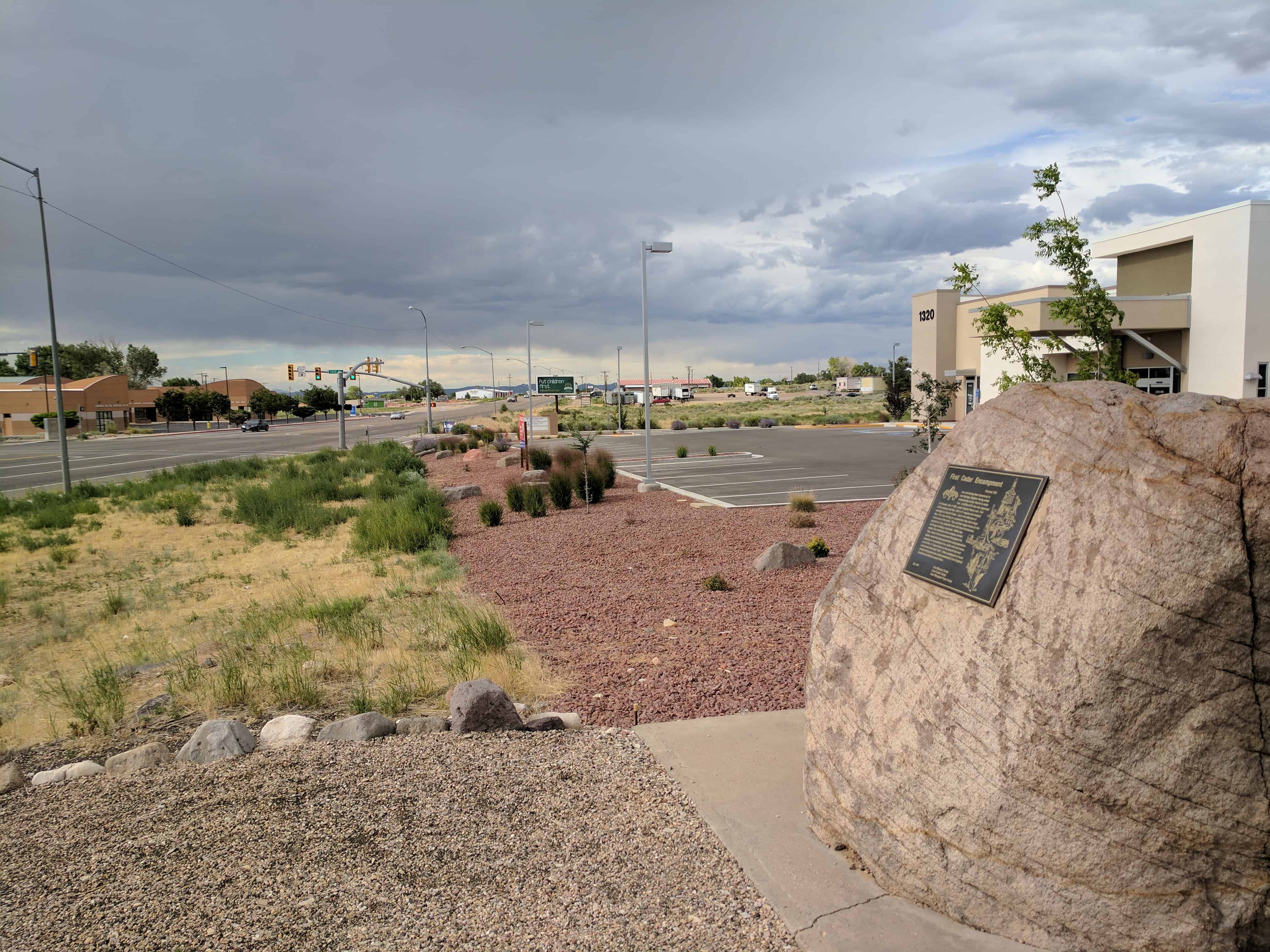
Iron ore having been discovered at Iron Springs, Brigham Young called missionaries to Iron County to make iron. A militia of 35 men was organized in Parowan, Nov. 5, 1851, under Captain Henry Lunt. Part of the company left Nov. 10th in 11 wagons and camped overnight in Summit Creek. Late in the afternoon of Nov. 11th, after driving in a snowstorm, they took refuge in the cove of this knoll. They set their wagon boxes on the ground in a line, protected them with brush enclosures, and began building a stockade. Within two weeks, the remainder of the company arrived. They lived in the encampment throughout the winter, made many explorations and preparations necessary to manufacture iron, built a fort and homes on the Wm. H. Dame survey to the west of the knoll and moved there April 1852. Other contingents of hand-picked immigrants were called periodically from England, Scotland and Wales to assist them.
Check out all of the historic markers placed by the Daughters of Utah Pioneers at JacobBarlow.com/dup
In 1854 Ogden pioneers built a rock and mud wall a mile square along 28th Street, Wall Avenue and 21st Street. Madison Avenue was not completed because the Indians became peaceful. The eight-foot wall had a six-foot base, a 31 inch top and four gates. The cost of $40,000 was raised by $40.00 tax on each city lot, also a $10.00 tax on every able-bodied man over 18 years. The project was erected by 500 working men. Wall Avenue was named after this wall.


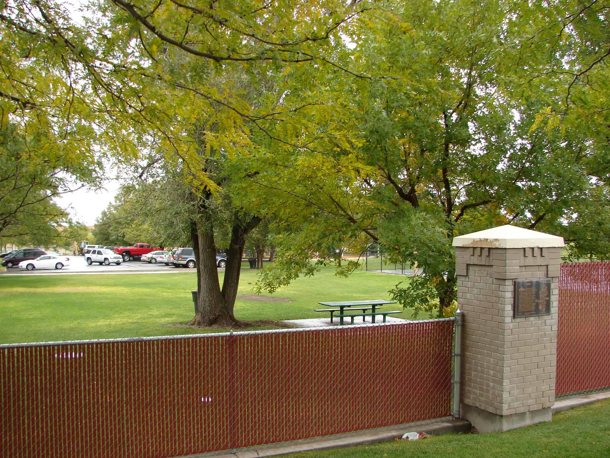 Homesteaders and settlers came in the 1870’s to the area 4700 South to 7200 West, north to the Great Salt Lake, northeast along it’s shore and the Davis County line to 4800 West and south to 4700 South. This area became Hunter Precinct in 1880 from the east part of Pleasant Green, and was named in honor of presiding Bishop Edward Hunter. The northern soil was too alkaline to farm. In 1881 the Utah Salt Lake Canal brought water to the central part. a 20′ x 30′ adobe chapel was erected in 1885 for religious meetings, 50th District School, and community activities. Hunter Branch became a ward in 1888. East of this site the 50th District School was built in 1891. The name was changed to Hunter School in 1906 and Whittier in 1908.