UPTLA#49 The granite used in the construction of the Mormon Temple in Salt Lake City was quarried from a large field of huge boulders covering this area broken by nature’s forces from adjacent cliffs. The quarrying of these boulders was begun about 1862 by James C. Livingston, under supervision of John Sharp. The names of the faithful quarrymen who continued the work until the Temple was finished in 1893 are enclosed in the monument. Rough stones were hauled about twenty miles to the temple site suspended under great two wheel carts drawn by ox-teams, until the railroad was built in 1872.
The monument was refurbished and moved in 2004 to its current location by the Temple Quarry Chapter of the SUP.
See other historic markers in the series on this page for UPTLA/SUP Markers.
In the early morning of May 1, 1900, several hundred miners of the Pleasant Valley Coal Company of Carbon County left their homes in the town of Scofield to begin another day of work in the mines. Some were looking forward to the evening celebrations at Odd Fellows Hall where festivities would be held in honor of Admiral Dewey’s 1898 defeat of the Spanish navy in the battle of Manila. Little did they know that the events of the day would culminate not in lively celebrations but in the death of 200 miners. It was the worst mine disaster in America to that time.
At 10:28 A.M. the No. 4 mine shaft unexpectedly exploded. Though the sound of the blast was heard in the nearby town, many residents thought at first that it came from fireworks set off early in celebration of Dewey Day. Those working closer to the mine were more wary of the noise. Mine superintendent T.J. Parmley quickly organized a rescue team to assess the damage.
What the relief crew saw as they approached the No. 4 mine was horrifying. John Wilson, a miner who had been standing at the opening of the mine at the time of the blast, had been blown 820 feet and was lying against a tree. It took nearly twenty minutes to clear away the debris that blocked the entrance to the mine. Time was crucial for those trapped inside. When the crew was finally able to enter the mine, they found that some men were still alive but quickly suffocating from the deadly gases left by the explosion. Miners in the No. 1 mining shaft, connected through tunnels to the No. 4, were also dying from the toxic fumes.
During the next two days the towns of Clear Creek and Scofield began the sad process of caring for the dead and wounded. Once dragged from the mining shafts, dead bodies were taken to the company boarding house where they were cleaned and dressed for burial. Then they were taken to the schoolhouse where mothers and wives anxiously waited to claim them.
The Pleasant Valley Coal Company provided the necessary materials to properly bury the dead. Coffins were shipped in from Salt Lake City and Denver. William Sharp, company manager, came from Salt Lake with several doctors to offer assistance to those who were still alive.
On May 5 two large funerals were held in Scofield, a Lutheran service for the 61 Finns killed in the accident and an LDS service directed by several General Authorities of the church. Services were also held in other towns throughout the state. Crowds of people waited at the Salt Lake train station for the bodies of loved ones to arrive for burial.
The Scofield mine disaster left a deep scar in the community and in Carbon County. Although many felt that the mine operators had failed to implement proper safety procedures, state officials cleared them of blame and the Pleasant Valley Coal Company continued operating until 1923. Since then, Scofield has become a ghost town. Several miles from the ruins of the town signs of a great explosion can still be found at the opening of the old No. 4 mine.
The geographic feature known as Bingham Canyon received its name from the location’s two first settlers, the brothers Thomas and Sanford Bingham, who arrived in the canyon in 1848. Initially, the area was utilized for livestock grazing and logging, but the region’s economic focus changed with the 1863 discovery of rich gold and silver ore bodies in the canyon. Mining activity in Bingham Canyon boomed after the Bingham Canyon and Camp Floyd Rail Road completed a line to the canyon in 1873, and as the region grew the focus shifted to the high-quality copper ores in the district. As the mines grew, the town of Bingham also expanded, spreading along the narrow and steep canyon floor below the mines.
Roy Newman was blinded and nearly killed when a stick of dynamite misfired in this mine in 1929. But the determined miner recovered and returned to work his mine alone – for another 45 years!
The belief that rich lead, zinc, and sliver ores lay deep in the mountain kept Roy working; he did encounter low-grade veins of oar. He drove 1,600 feet using only hand-held drills, a four-pound hammer, explosives, and his ingenuity.
Though blind, Roy could faintly detect light in the corner of one eye and he used this ability to keep the mine workings straight. Roy would set a carbide lamp in the middle of the track, several hundred feet from the mine’s working face. Then he would stand a pick, with its handle up, in the track a few feet from the face. Standing between the pick and the face, Roy moved his head back and forth until the pick block the light. Repeating this process, he was able to continually center and straighten the workings.
Roy lived alone in a cabin near the mine through the pleasant summers and long, harsh winters. With the help of friends and family, who kept him supplied with food and other basic needs, he maintained his optimism and persevered. “I like the challenge that Mother Nature presents the miner who searches for her secrets,” he said.
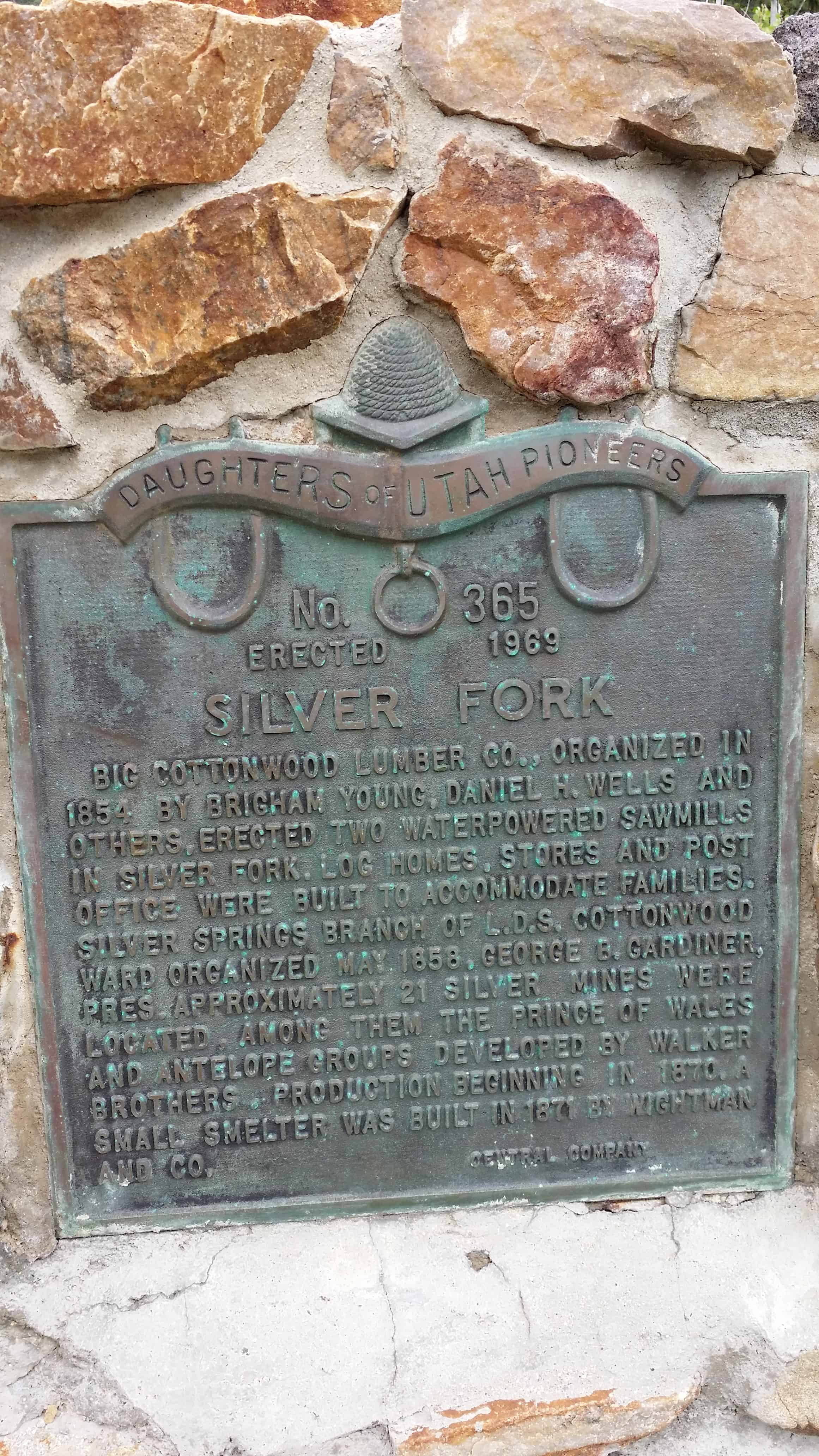
Big Cottonwood Lumber Co., organized in 1854 by Brigham Young, Daniel H. Wells and Others, erected two waterpowered sawmills In Silver Fork. Log homes, stores and post Office were built to accommodate families. Silver springs branch of the L.D.S. Cottonwood Ward organized may 1858, George b. Gardiner, Pres. Approximately 21 silver mines were Located. Among them, the prince of wales and antelope groups developed by Walker Brothers. Production beginning in 1870. A small smelter was built in 1871 by Wightman And Co.
Silver Fork is one of the last forks branching to the south in Big Cottonwood Canyon before reaching Brighton and Silver Lake. Silver Fork, the canyon, is today best known for the large concentration of summer homes and family cabins at its mouth that is Silver Fork, the town.
From the present day tree covered appearance you would hardly guess that this area began as a base for early logging operations. It would be more than 20 years before mining would play a part in the area’s history.
Logging began shortly after the arrival of the pioneers in 1847, by 1854 the Big Cottonwood Lumber Company was in operation with two saw mills and a shingle mill. The mills were located on the flats at the mouth of Silver Fork. A small community of log buildings quickly sprang up around the operation, all there to support the mills and lumbermen who worked them. In time the sawmills relocated and the town was partially abandoned.
By 1870, the one time logging camp became a mining camp. It didn’t take long for the flurry of activity in Little Cottonwood Canyon at Alta to spill over the ridge and into the tops of Silver and Honeycomb Forks. With that activity, and the rush that accompanied it, the town came to life, supporting the mines just as it had the loggers previously. A small smelter was constructed, another hotel, commercial buildings, and the once abandoned cabins, became homes again.
This second life of the town would be short lived, as the mining boom ended by the mid 1880’s. Some mining did take place after this time, but larger mills and smelters in the valley and improved transportation methods combined to set Silver Fork up for its second abandonment.
In 1893, the area was homesteaded by Joy Dunyon who ran sheep in the fork for many years. Around 1925, the Dunyon family who still owned the property, subdivided the land, and the present community of Silver Fork with its many summer homes and mountain cabins came to be.(1) The third life of the town has never ended, and the fork has been a hiking destination in the summer, and a back country skiing area in the winter. It is the skiing that may most directly affect the town and the futuer of Silver Fork.
A fourth life to the area may be in the works. Just this year (2010) Solitude Ski Resort made application to expand their ski resort operations into Silver Fork. At least a part of it. The original application that would have opened the entire fork, some 463 acres, was withdrawn or denied, depending on who you talk to. A second, smaller impact application was then submitted. This application would open 182 acres, pretty much the entire east face of the fork from the ridge with Honeycomb Fork down the slope to within 100 feet of SIlver Creek along its entire length.
If this access were granted, it would encompass almost all of the historic mining sites in Silver Fork, including the Prince of Wales, Wellington, and others. What remains may have to be “reclaimed” to make it safe for the rest of us. If the state does this work, it usually means destroying it. I hope that preservation would be mandated as a part of any permit, but that is a battle yet to be fought.
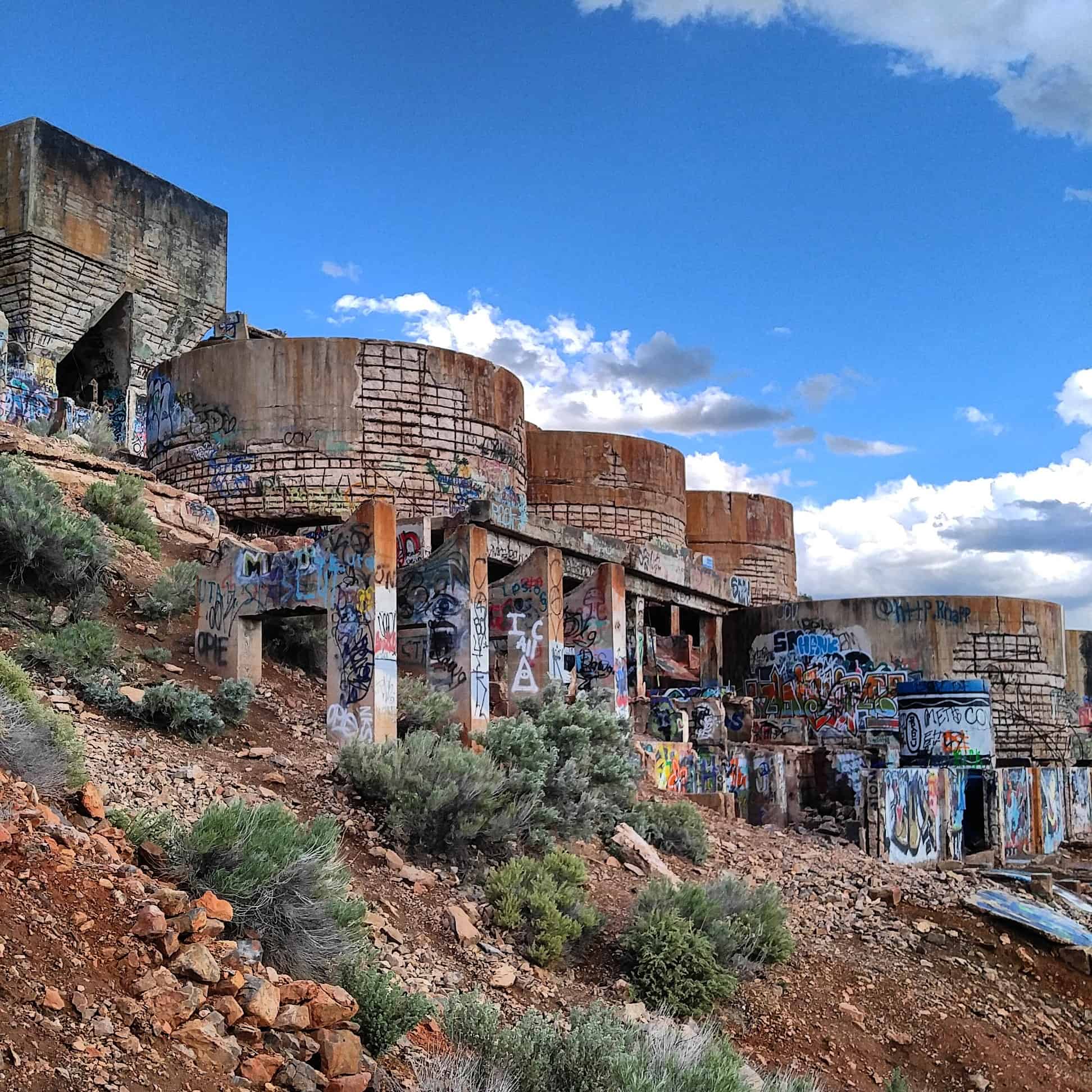
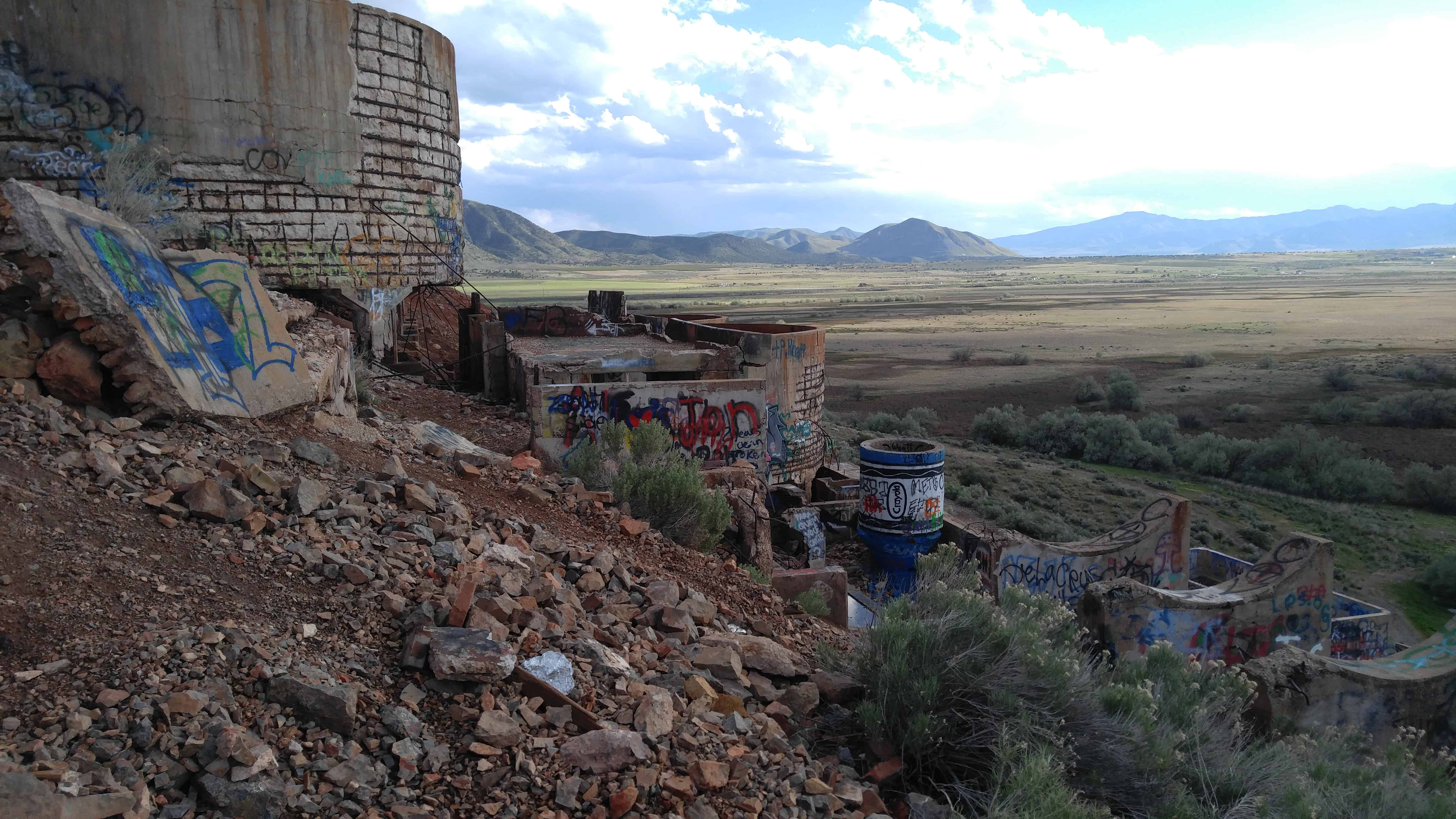
While that third life goes on, the fourth life being argued, the second life is the focus of this work; the mining boom. One of the earliest mines in the entire territory to have a steam compressor, the Wellington, is found in Silver Fork as well as the Prince of Wales, Antelope, Highland Chief, Boston Tunnel, Alta Tunnel, Star Tunnel, Warrior, Lucky Dutchman and more.
Silver Fork is also the access-way for a large branch fork to the east and south, Honeycomb Fork.
Silver Fork has no structures that remain standing from those early days, but there is hardware, some of it partially buried, but visible nonetheless. That which can be seen, shows the beauty and craftsmanship of those metal workers who designed and built the machinery of mining.(*)
Driving highway 6/50 between Price/Helper and Spanish Fork, in Price Canyon not too far from Helper, Utah you can see an area to pull off the highway with a lot of history to read.
Diamondville got its name from the quality of the superior-grade coal from the local mines that seemed to resemble black diamonds.
In 1868, a man by the name of Harrison church discovered coal near the Hams Fork River. He built a cabin on the hill where part of modern Diamondville now stands. Realizing the area’s potential, he sought financial backing from a group in Minneapolis, who eventually formed the Hams Fork River Coal Company, incorporated in 1884. Later S.F. Fields, a promoter from Salt Lake City, Utah, took over management of the company and with the financial backing of the Anaconda Mining Company, renamed it the Diamond Coal & Coke Company.
Over the course of time the development of a western coal mine evolved from digging out and hauling coal by hand from an outcrop or tunnel to today’s mechanical monsters of the plains.
Draglines and truck and shovel operations now remove up to several hundred feet of overburden in order to expose the coal. Conveyor belts and haul trucks transport hundreds of tons each minute to sophisticated automated silos that evenly distribute carefully measured loads onto unit trains. A man used to be paid by the number of tons he dug; today what took days of back breaking labor to dig can be moved in a matter of seconds by a single shovel operator.
The uses for coal have also changed, chunks of coal used to be burned in old stokers and forges for heating purposes. Today coal is crushed, pulverized and sprayed into furnaces to generate steam which is then used to generate electricity. Synthetic fuels or “synfuels” are also generated from Wyoming coal. Currently only a very small percentage of Wyoming’s coal is used as form coke in steel manufacturing.
In the 1860’s steam engines were starting to use coal instead of wood. The recognition of the western coal resource potential had only begun. Also, coal’s high Btu ( British Thermal Units ) made it more favorable to burn than wood. The benefits of using coal were that it increased horsepower, increased the distance that steam engines of the time could travel and was readily available. Wyoming’s abundance of coal and general topography in conjunction with the ongoing Civil War served as deciding factors on the choice of the northern route across southern Wyoming for the Transcontinental railroad.
There are four main steps to mining coal
Step One
Coal must be broken away from the face of the coal seam.
In the early mines picks were used to break the coal away from the face, then holes were drilled in the face and dynamite was into the hole and detonated (1900 – 1950).
Step Two
Coal must be gathered up and loaded into a conveyance to hual it out of the mine.
In the first mines, coal was gathered up and loaded by hand with a coal shovel into the car.
Step Three
Coal has to be transprted out of the mine.
The first coal cars were pushed out of the mine by hand, then mules were used to pull the cars.
Step Four
The coal is prepared and delivered to the consumer.
In the early mines the coal was brought out of the mine in big chunks and loaded onto a horse-drawn wagon.
In Helper I stopped by a cool little park that was more of a mining equipment museum.
The Four Steps Necessary For Mining Coal
Step One
Coal must be broken away from the face of the coal seam.
In the early mines picks were used to break the coal away from the face, then holes were drilled in the face and dynamite was into the hole and detonated (1900 – 1950).
The Tintic Standard Reduction Mill presently stands in partial ruin. Drawings prepared by the HAER survey show front and side elevations, as well as a general plan of the mill’s remains. Enough exists to identify the structure as a mill, and to visualize the procedures involved in the milling process. It remains at the original location, Warm Springs, Utah, some two miles east of the town of Goshen in Utah County. The mill was erected on a hillside for gravity purposes.
Originally the mill contained water tanks, ore bins, crushing rolls, Holt-Dern roasters, iron boxes, leaching tanks, and to the side, drain boxes for lead precipitate. While the actual machinery is gone, the shell of the structure remains.
The Tintic Standard Reduction Mill (Harold Mill) was constructed during the 1919-1921 period by the Tintic Standard Mining Company, under Emil John Raddatz, prominent Utah mining entrepreneur. It served as the mill for the Tintic Standard, which became one of the nation’s leading silver producers, operating from 1916 to approximately 1945.
The significance of the mill, in addition to its place as a part of Tintic Standard’s operation, is attributable to its importance in the themes of engineering and industry. W. C. Madge designed and constructed the mill after having consulted with Theodore P. Holt and George H. Bern, Utah developers of the Holt-Dern Roaster. It was built at a cost of $580,000. The Tintic Standard Reduction Mill was the only use of the “antiquated” Augustin process in the United States during the early years of the 1920s. The plant was an acid brine chloritizing and leaching mill. Ore was first roasted with salt, then leached in a strong brine solution and finally precipitated with copper. Recovery rates were fairly high, as in 1924, when the mill recovered 88% of the silver, 60% copper. 32% lead and 7% of the gold held in the ore.
As related to industry, the mill was an important part of Tintic Standard’s operation. In addition, the construction of the plant also reflected the battle, then waging, over railroad transportation rates, which mine owners believed were too high. By milling the ore themselves, owners could save the shipping costs. By 1925, the mine could no longer supply ore of the grade for which the mill was designed. Also, by then, shipping rates declined, therefore, in the fall of that year, the plant shut down.
A town grew up near the mill, named “Harold” after Raddatz’s son. Only the site remains, nevertheless, the town site and especially the mill, aids both in the documentation of mining history and also in the affect this operation had upon nearby small fanning communities such as Goshen, causing them to experience “Boom periods” in their development,
Many people driving from Goshen towards Genola and Santaquin see the Mill up on the mountain and wonder what it is, it is quite curious looking.
The Tintic Standard Reduction Mill is located on the hillside above Genola, Utah and was added to the National Register of Historic Places (#78002700) on September 13, 1978.
Here are my photos from a trip on 09 May 2016:
The Tintic Standard Reduction Mill (Harold Mill) was constructed during the 1919-1921 period by the Tintic Standard Mining Company, under Ernie J. Raddatz, prominent Utah mining entrepreneur. It served as the mill for the Tintic Standard, which became one of the nation’s leading silver producers, operating from 1916 to approximately 1945.
The significance of the mill, in addition to its place as a part of Tintic Standard’s operation, is attributable to its dunportance in the themes of engineering and industry. W. C. Madge designed and constructed the mill after having consulted with Theodore P. Holt and George H. Bern, Utah developers of the Holt-Dern Roaster. It was built at a cost of $580,000. The Tintic Standard Reduction Mill was the only use of the “antiquated” Augustin process in the United States during the early years of the 1920s. The plant was an acid brine chloridizing and leaching mill. Ore was first roasted with salt, then leached in a strong brine solution and finally precipated with copper. Recovery rates were fairly high, as in 1924, when the mill recovered 88% of the silver, 60% copper. 32% lead and 7% of the gold held in the ore.
As related to industry, the mill was an important part of Tintic Standard’s operation. In addition, the construction of the plant also reflected the battle, then waging, over railroad transportation rates, which mine owners believed were too high. By milling the ore themselves, owners could save the shipping costs. By 1925, the mine could no longer supply ore of the grade for which the mill was designed. Also, by then, shipping rates declined, therefore, in the fall of that year, the plant shut down.
A town grew up near the mill, named “Harold” after Raddatz’s son. Only the site remains, nevertheless, the town site and especially the mill, aids both in the documentation of mining _ history and also in the affect this operation had upon nearby small fanning communities such as Goshen, causing them to experience “Boom periods” in their development,
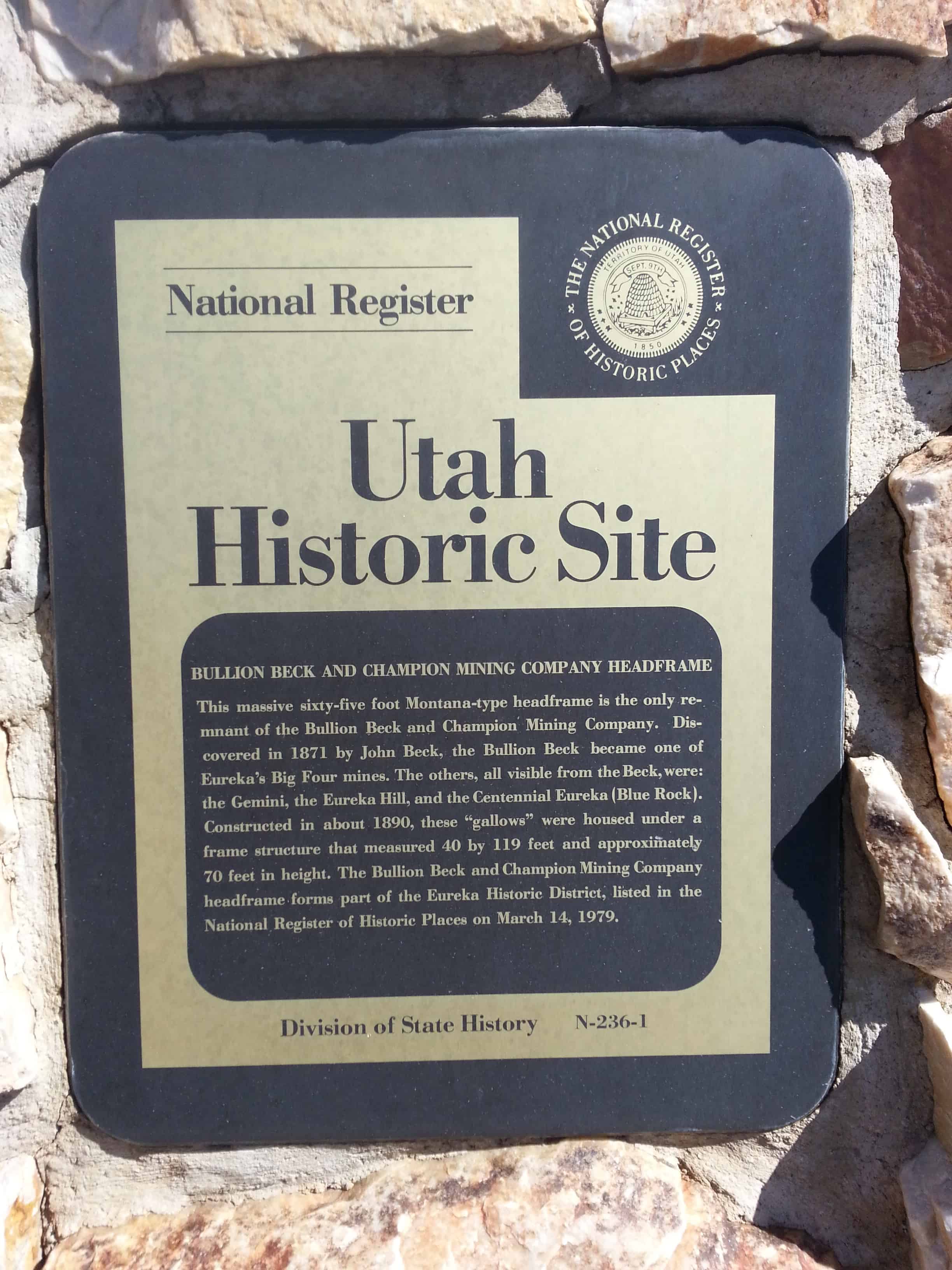
BULLION BECK AND CHAMPION MINING COMPANY HEADFRAME This massive sixty-five Montana type Headframe is the only remnant of the Bullion Beck & Champion Mining Company. Discovered in 1871 by John Beck, the Bullion Beck became one of Eureka‘s big four mines. The others, all visible from the Beck, were the Gemini, the Eureka Hill, and the Centennial Eureka or Blue Rock. Constructed in about 1890 these gallows were housed under a frame structure that measured 40 x 119 feet and approximately 70 feet in height. The Bullion Beck & Champion Company Headframe forms part of the Eureka Historic District listed in the National Register of Historic Places on March 14, 1979.
THE BULLION BECK & CHAMPION MINING COMPANY HEADFRAME
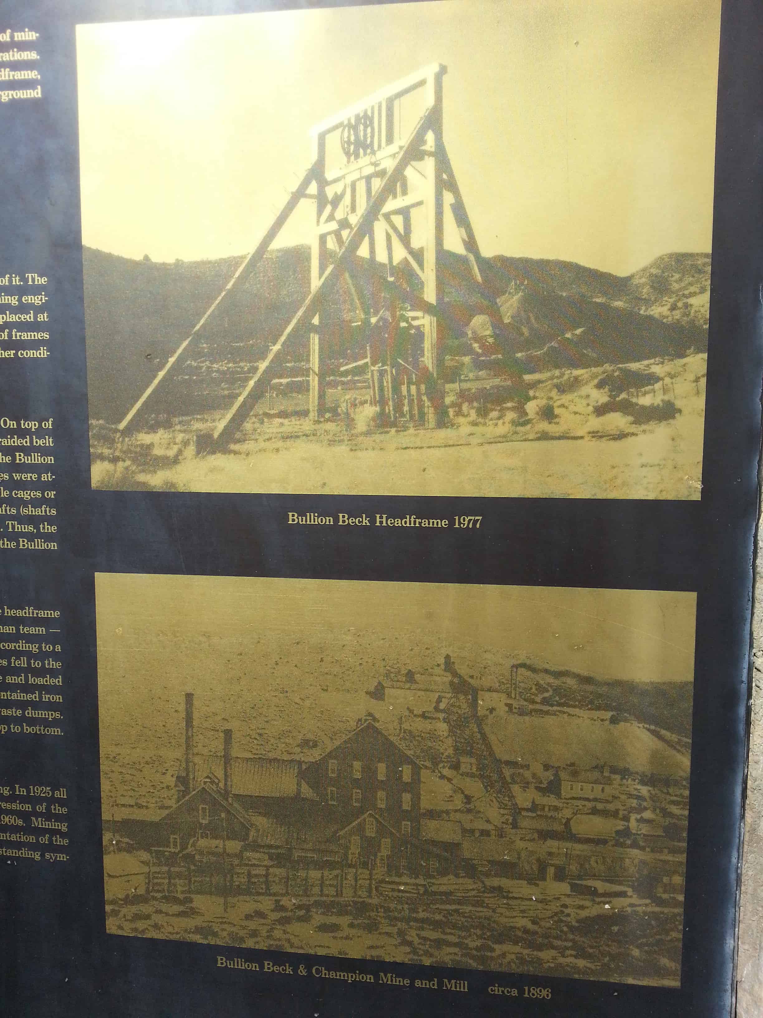
Perched over deep mining shafts, headframes or gallows frames illustrate the development of mining from small individually owned prospects to the large- scale operation of mining corporations. Technological innovations were required to accomplish this change. The Bullion Beck headframe, constructed in 1890, served to transport men, mules, supplies, and ore in and out of the underground workings. “The Salt Lake Tribune”, January 1, 1891, described the newly constructed plant:
Over the shaft is a main building of hoisting works. This is a substantially-framed structure, 40 x 119 feet, and high enough to take in the gallows frame, that being one of the best and strongest in the country and 60 feet in height. There are no better frame timbers or larger ones than these in Utah.
Headframes were of various types- the 4- or 6-post type and the A-type or modifications of it. The Bullion Beck gallows is A-type, also called two-post headframe or Montana type. Mining engineers’ handbook contains stress sheets and diagrams that illustrate how all bracing was placed at angles and in positions designed to hold the weight and stress needed to do the job. Sizes of frames depended on load weight, shaft size and depth, special equipment requirements, and weather conditions if exposed.
The Headframe allowed mining from depths of 300 to over 3,000 feet below the surface. On top of this frame sits sheaves, large wheels over which ran the hoisting rope. The rope, first a braided belt then a wire cable, ran from the hoisting engines some distance from the headframe. Bullion Beck had two Frazer and Chalmers 500 horse-power engines. The ropes from the sheaves were attached to cages that traveled in and out of the vertical shaft. These could have single cages or double-decked and had sections of track attached for rolling in ore cars. In inclined shafts (shafts descending at an angle) all self-dumping ore cars with wheels called skips were used. Thus, the vertical beams running in the center of the frame are often labeled skip guides. Those of the Bullion Beck were partially reconstructed in 1987.
Hoisting was the process of getting men, equipment, and ore in and out of the mine. The headframe served as part of the hoisting plant or works. Basically, the process involved a three-man team – hoist operator, top lander and cage tender. The hoist operator ran the hoisting engine according to a set system of bell signals. Removing loaded ore cars and sending down the empty ones fell to the top lander, while the cage tender delivered the loads to the different levels of the mine and loaded cars of ore or overburden to be sent to the surface. The floor at the top of the shaft contained iron plates and tracks for the cars so that they could be sent to the ore bins or to the waste dumps. Bullion Beck Mine contained a double compartment shaft with a man-way from top to bottom. The timber-lined shaft collar is now covered.
The surface plant of the Bullion Beck Mine was originally enclosed in a wooden building. In 1925 all of the plant was demolished except the headframe, which sat idle during the depression of the 1930s. It reopened due to World War II demand and operated into the early 1960s. Mining historians view the headframe as “the most prominent feature in almost any representation of the ordinary mine of the frontier period.” These wooden gallows are very rare. Those standing symbolize the important of the western mining landscape.