• About JacobBarlow.com
  • Cemeteries in Utah
  • D.U.P. Markers
  • Doors
  • Exploring Utah Email List
  • Geocaching
  • Historic Marker Map
  • Links
  • Movie/TV Show Filming Locations
  • Oldest in Utah
  • Other Travels
  • Photos Then and Now
  • S.U.P. Markers
  • U.P.T.L.A. Markers
  • Utah Cities and Places.
  • Utah Homes for Sale
  • Utah Treasure Hunt

JacobBarlow.com

~ Exploring with Jacob Barlow

JacobBarlow.com

Monthly Archives: July 2018

Gates-Snow Building

15 Sunday Jul 2018

Posted by Jacob Barlow in Uncategorized

≈ 1 Comment

Tags

historic, Historic Buildings, Provo, utah

2018-03-10 13.35.09

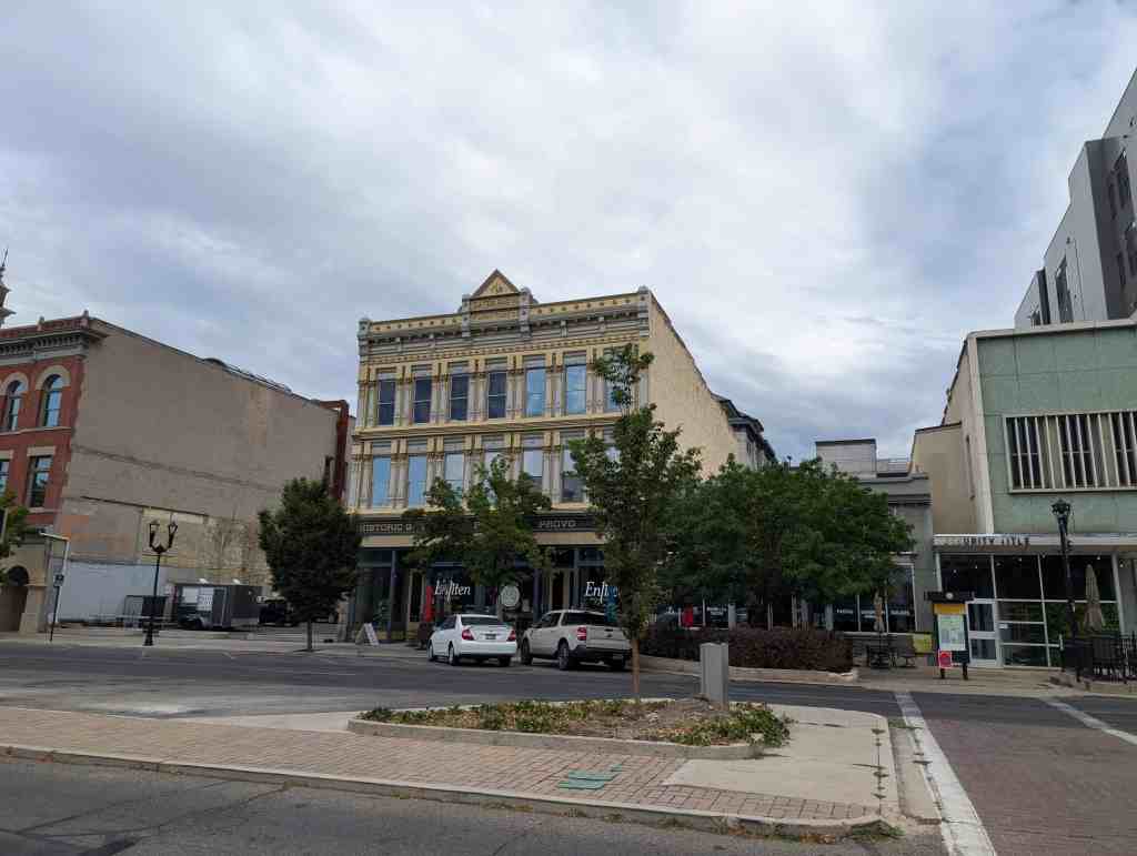
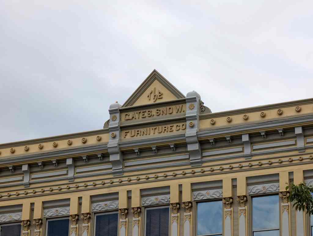
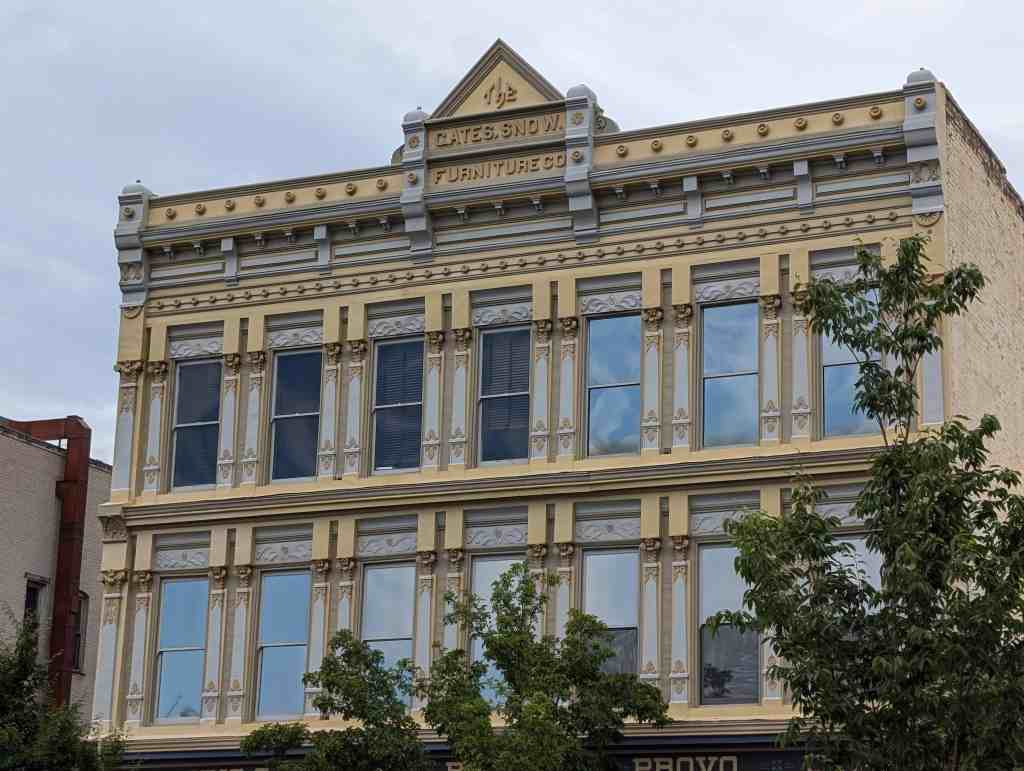
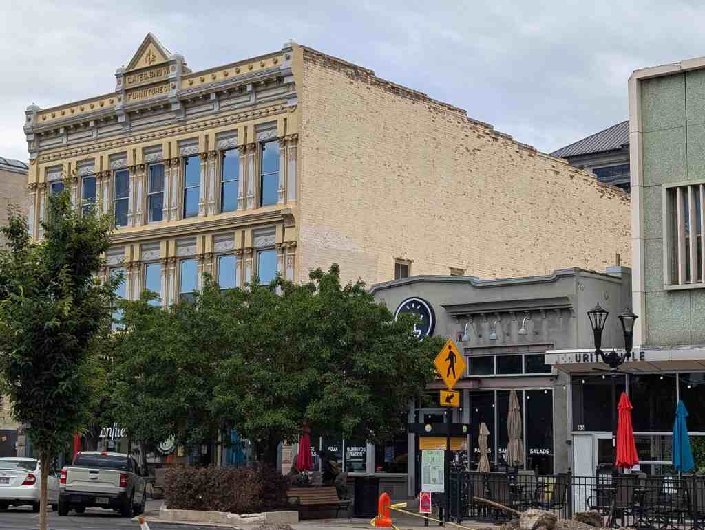
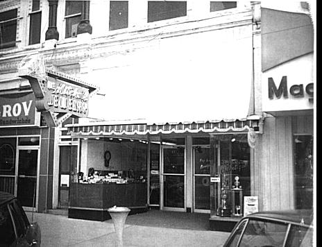
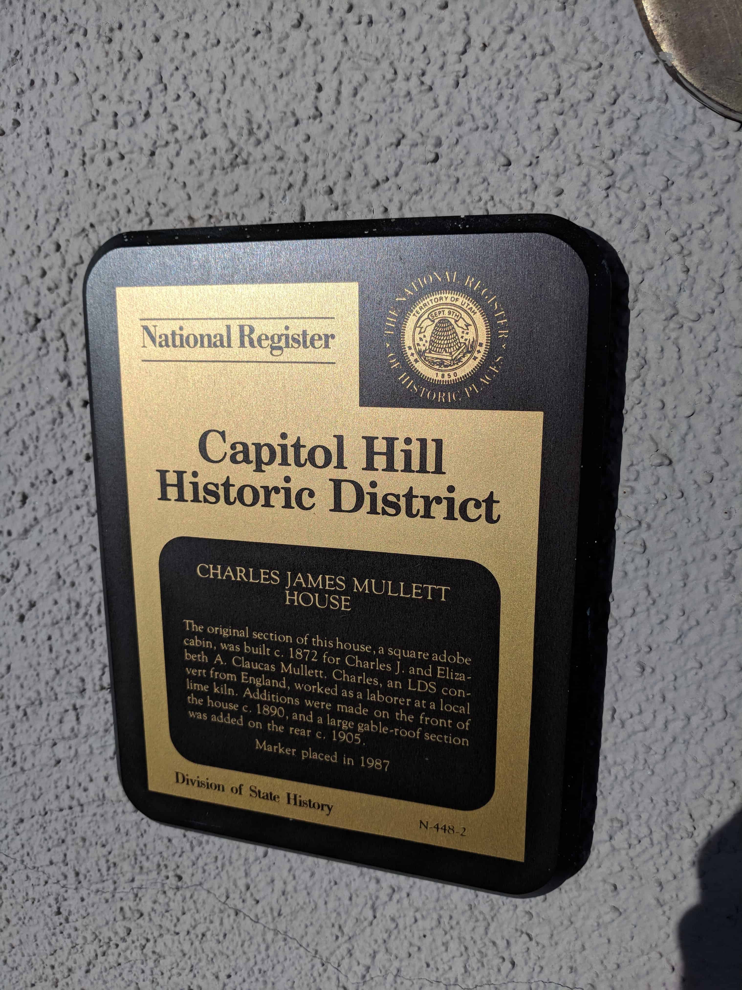
The historic Gates-Snow Building on Provo Center Street.

When Provo residents wanted to buy furniture in the 1880s and 1890s, they had two large choices—Snow Brothers and Taylor Brothers. In December 1886 the Salt Lake Daily Herald announced, “The large and varied stock of furniture . . . at the store . . . seems to indicate that the firm does a large business or else there is some capital unwisely invested. . . . The entire stock of goods . . . might be regarded as one immense display of useful and substantial articles suitable for holiday presents.” In 1887 the newspaper declared, “There appears to be just enough competition” between the Snows and the Taylors. In 1889 the Snow Brothers expanded their store and moved from the first floor the Academy boarding house to the old Factory store across the street from the courthouse. They added a story to the building.

In May 1889 the Salt Lake newspaper declared, “Snow Brothers, the furniture deals, are now established in their new quarters—prouder than ever.” The next year Snow added J. F. Gates as a partner. The new company tore down the existing building and completed a three story building. The paper bragged that it could be expanded to a five story building. The construction of glass and iron resembled the Culmer block in Salt Lake City. According to the Daily Enquirer, “The business of this firm has been rapidly increasing during the past year, making a new building a necessity.” The business’ success did not last.

In 1890 a depression hit Provo, Utah, and the rest of the United States. The impressive building was completed in October 1890. By April 1891 the store was going out of business. According to the Daily Enquirer, “Owing to the stringency in business circles, the Gates-Snow Furniture Company has decided at least temporarily to suspend business and rent their large building.” The owners planned to rent the bottom floor as two stores, the second floor as offices, and the third floor for lodge rooms. Business picked up though, and the December 25, 1892 Provo Herald declared, “J. F. Gates . . . is a business man of merit and conducts a large and growing furniture establishment.” Part of the building was still rented.

The county fair opened offices on the second floor in 1897. In 1898 Jesse Knight purchased the building for $3,600. In 1902 Gates and Snow dissolved their furniture partnership, and M. Snow continued to sell furniture. Gates and Snow continued to operate an insurance business. The Gates-Snow building housed several businesses over the years. In 1901 the Skelton Publishing Company moved from the building to a new one on Academy Avenue. William M. Roylance also had an office there and purchased the building in 1905. Judge M. M. Kellogg, the judge of the juvenile court, established there that year. The corner, according to the Salt Lake Tribune, became “the busiest section of Provo” when the Independent Telephone Company moved into the Gates-Snow building and the Western Union and Rocky Mountain Bell Telephone Company planned offices nearby.

In the 1890s walking by the Gates-Snow building could be a “shocking” experience. According to the Daily Enquirer, the steel front “was strongly charged with electricity . . . on account of defective wiring.” As a result, “a great many persons standing on the wet ground and coming in contact with the building received an electric shock. The defect was soon remedied.” The next year a small fire broke out in the lumber coal bin. Someone had started a bonfire to burn papers. However, “the fire was extinguished in a few minutes. The loss was slight.” -Research by D. Robert Carter

37 East Center Street in Provo, Utah

gates-snow
2018-03-10 13.35.15
2018-03-10 13.35.12

Related posts:

  • Provo
  • Provo Center Street

Provo Center Street

15 Sunday Jul 2018

Posted by Jacob Barlow in Uncategorized

≈ 25 Comments

Tags

historic, Historic Buildings, Historic Markers, Provo, utah, utah county

2018-03-10 13.35.12

Historic and Interesting Sites on Provo Center Street.

  • Downtown Pictures from March 2018
  • 550 W Center St
  • 495 W Center St
  • 466 W Center St – Provo West Co-op
  • 464 W Center St
  • 450 W Center St
  • 444 W Center St
  • 440 W Center St
  • 436 W Center St
  • 434 W Center St
  • 425 W Center St
  • 402 W Center St
  • 384 W Center St
  • 368 W Center St
  • 362 W Center St
  • 354 W Center St
  • 351 W Center St
  • 350 W Center St
  • 342 W Center St
  • 336 W Center St
  • 332 W Center St
  • 330 W Center St
  • 322 W Center St
  • 295 W Center St
  • 288 W Center St
  • 286 W Center St – B & H Pharmacy Sign
  • 278 W Center St
  • 265-273 W Center St
  • 255 W Center St
  • 250 W Center St – Taylor Brothers Building
  • 247 W Center St
  • 241 W Center St – Anderson’s Garage
  • 230 W Center St – Startup Candy
  • 226 W Center St – Jones Barber Shop
  • 225 W Center St
  • 223 W Center St
  • 220 W Center St (former building)
  • 220 W Center St – Convention Center
  • 210 W Center St – Provo Exchange Building
  • 204 W Center St
  • 201 W Center St
  • 198 W Center St and Dolphin Mural
  • 190 W Center St
  • 187 W Center St
  • 184 W Center St
  • 175-177 W Center St
  • 176 W Center St
  • 168 W Center St
  • 164 W Center St
  • 163 W Center St
  • 157 W Center St
  • 154 W Center St
  • 152 W Center St
  • 144 W Center St
  • 143-153 W Center St
  • 137 W Center St
  • 129 W Center St
  • 125-127 W Center St
  • 110-120 West Center
  • 105 W Center St – Kress Building
  • 104 W Center St
  • 98 W Center St
  • 85 W Center St
  • 75 W Center St – Nu Skin Enterprises
  • 61 W Center St
  • 56 W Center St – Martha Hughes Cannon
  • 36 W Center St – Union Block
  • 8 W Center
  • 1 E – The Knight Block
  • 37 E Center St – Gates/Snow Building
  • 45 E Center St
  • 55 E Center St – The Rocky Mountain Bell Telephone Company
  • 63 E Center St
  • 69 E Center St
  • 71 E Center St
  • 100 E Center – County Building
  • 145 E Center
  • 185 E Center – Jesse Knight Home
  • 201 E Center St
  • 237 E Center St – J. Albert Scorup House
  • 257 E Center St
  • 275 E Center St
  • 289 E Center St – J. William Knight House
  • 315 E Center St – Hannah Maria Libby Smith House
  • 370 E Center St
  • 381 E – Knight-Mangum Mansion
  • 390 East Center St – Knight-Allen House
  • 415 E Center St – Alma Van Wagenen House
  • 418 E Center St – Preston Geddes House
  • 424 E Center St – Ambrose P. Merrill House
  • 425 E Center St – Lizzie V. Sutton House
  • 441 E Center St
  • 461 E Center St – John C. Graham House
  • 575 E – Historic Firmage House
  • 589 E – Fred R. and Mary J. Taylor House
  • 610 E – S.A. Strawhorne House
  • 636 E – C.W. Reid House
  • 665 East – Farrer Elementary School / Provo Peaks Elementary
  • 740 E – Leven-Wolf House
  • 770 E – Pierpont Mansion
  • 905 E – Van Wagenen House
  • 939 E – Justis Johnson House
  • 957 E – Pierpont House
  • 984 E – James E. Snyder House
  • Tunnels

The photos below were found on the county’s public record site.

420 Second Avenue

15 Sunday Jul 2018

Posted by Jacob Barlow in Uncategorized

≈ 1 Comment

Tags

Avenues, historic, Historic Homes, NRHP, Salt Lake City, Salt Lake County, utah

2018-01-13 15.51.47

420 Second Avenue

This house was built in 1900 for Susan Riter and Charles H. Wells for $2,799.  Susan was a member of the Daughters of American revolution, Colonial Dames, and the Spanish American War Veterans Auxiliary.   Charles, son of Daniel H. Wells, first mayor of Salt Lake City, was the recieving teller at the State Bank of Utah, later working for the city engineer’s office and P.J. Moran contracting.  He lived here until his death in 1945.  Lynn A. McKinlay, produced for KSL, lived here until 1953.

Located at 420 East Second Avenue in the Avenues of Salt Lake City, Utah.

2018-01-13 15.51.51

2018-01-13 15.51.36

The Garden Restaurant

11 Wednesday Jul 2018

Posted by Jacob Barlow in Uncategorized

≈ Leave a comment

2018-05-04 20.53.31

The Garden Restaurant in the Joseph Smith Memorial Building on Temple Square.

2018-05-04 20.53.27

2018-05-04 20.54.38

Charles James Mullett House

11 Wednesday Jul 2018

Posted by Jacob Barlow in Uncategorized

≈ 1 Comment

Tags

Capitol Hill Historic District, Historic Homes, NRHP, Salt Lake City, Salt Lake County, utah

2018-04-09 19.25.05

Charles James Mullett House

The original section of this house, a square adobe cabin, was built c.1872 for Charles J. and Elizabeth A Claucas Mullett.  Charles, an LDS convert from England, worked as a laborer at a local lime kiln.  Additions were made on the front of the house c.1890, and a large gable-roof section was added on the rear c.1905.

See other historic homes in Salt Lake on this page.

Related:

  • Capitol Hill Historic District

680 North Wall Street in Salt Lake City, Utah

2018-04-09 19.23.27
2018-04-09 19.24.29
2018-04-09 19.23.57

Center Street Church

11 Wednesday Jul 2018

Posted by Jacob Barlow in Uncategorized

≈ 1 Comment

Tags

Historic Churches, Springville, utah, utah county

  • 2018-03-10 10.23.01

The chapel at 355 E Center Street in Springville, Utah was built in 1936 for the 4th Ward.

Tonaquint

11 Wednesday Jul 2018

Posted by Jacob Barlow in Uncategorized

≈ Leave a comment

Tags

historic, Historic Markers, St. George, SUP, utah, Washington County

2018-02-19 17.42.52

Tonaquint

This is a historic marker located in Crosby Family Confluence Park in St. George, Utah.

This is S.U.P. Marker # 173, see the others in the series on this page.

Jacob Hamblin, pioneer, missionary and friend to the Indians, planted cottonseed in the fertile river bottoms near here in 1855. A settlement was established the next year called Tonaquint, after a local band of Indians that were located there. As part of the Cotton Mission, four families built a few log cabins and willow huts. Sometimes called Lower Clara, with nicknames of Seldom Sap, Never Sweat and Lick Skillet, it was abandoned in 1862 due to a series of floods. However, some farming was continued and it was later known as Seep Ditch.

2018-02-19 17.42.57

Brigham Young’s Vision

11 Wednesday Jul 2018

Posted by Jacob Barlow in Uncategorized

≈ Leave a comment

Tags

historic, Historic Markers, St. George, SUP, utah, Washington County

2018-02-19 17.41.10

Brigham Young’s Vision

This is a historic marker located in Crosby Family Confluence Park in St. George, Utah.

This is S.U.P. Marker # 174, see the others in the series on this page.

Near this spot, in the fall of 1859, Brigham Young, statesman and leader of the Mormon people, silently gazed at Pine Valley Mountain, and then the valley and hills of black lava and vermillion rock before him. He saw in vision a thriving community. With a sweep of his arm he spoke: “There will yet be built between those volcanic ridges, a city of spires, towers and steeples, with homes containing many inhabitants.”

2018-02-19 17.41.18

Jedediah Strong Smith

11 Wednesday Jul 2018

Posted by Jacob Barlow in Uncategorized

≈ Leave a comment

Tags

historic, Historic Markers, St. George, SUP, utah, Washington County

2018-02-19 17.40.30

Jedediah Strong Smith

This is a historic marker located in Crosby Family Confluence Park in St. George, Utah.

This is S.U.P. Marker # 176, see the others in the series on this page.

In 1826, Jedediah Smith, searching for a route to California, entered what is now Washington County by crossing the black ridge north of here then following Ash Creek to the Virgin River. He followed the Virgin River through the Virgin River Narrows (present route of I-15) overcoming many dangers associated with the steep, narrow, winding, rugged canyon. In 1827, he returned to California following the same route to the confluence of Santa Clara Creek and the Virgin River. Anxious to avoid a repetition of his experience in the Virgin River Narrows, he proceeded up Santa Clara Creek and turned southwest over the low mountain (present day Old Highway US 91) to a ravine which led him to the Beaver Dam Wash and its confluence with the Virgin River.

2018-02-19 17.40.39

The Southern Exploring Company

11 Wednesday Jul 2018

Posted by Jacob Barlow in Uncategorized

≈ Leave a comment

Tags

historic, Historic Markers, St. George, SUP, utah, Washington County

2018-02-19 17.39.45

The Southern Exploring Company

This is a historic marker located in Crosby Family Confluence Park in St. George, Utah.

This is S.U.P. Marker # 175, see the others in the series on this page.

In the fall of 1849, Brigham Young formed the Southern Exploring Company led by Parley P. Pratt. Through that winter this company of 50 men explored potential town sites and resources from Nephi to present day St. George as part of Young’s plan for a corridor to the sea, also called the Mormon Corridor. Twenty of the company under Pratt reached their further point south at the confluence of the Santa Clara and Virgin Rivers on January 1, 1850, near this monument. Their reports resulted in the settlement of all the towns between Nephi and St. George.

2018-02-19 17.39.55

← Older posts
Newer posts →

Follow Jacob

Follow Jacob

Come wander with me on Youtube.

Blog Stats

  • 2,100,994 hits

Social and Other Links

BarlowLinks.com

Recent Posts

  • Scout Monument
  • Provo High School Seminary Building
  • 821 E 100 S
  • 820 E 100 S
  • 817-819 E 100 S

Archives

Loading Comments...