• About JacobBarlow.com
  • Cemeteries in Utah
  • D.U.P. Markers
  • Doors
  • Exploring Utah Email List
  • Geocaching
  • Historic Marker Map
  • Links
  • Movie/TV Show Filming Locations
  • Oldest in Utah
  • Other Travels
  • Photos Then and Now
  • S.U.P. Markers
  • U.P.T.L.A. Markers
  • Utah Cities and Places.
  • Utah Homes for Sale
  • Utah Treasure Hunt

JacobBarlow.com

~ Exploring with Jacob Barlow

JacobBarlow.com

Tag Archives: Historic Buildings

Cove Fort

03 Wednesday May 2017

Posted by Jacob Barlow in Uncategorized

≈ 5 Comments

Tags

Cove Fort, Forts, Historic Buildings, Millard County, NRHP, utah

IMG_20170326_145551_369

The Indians called the site Pa-Hump-Pa (Cove Creek); Mormon emigrants named it Cove Creek. Cove Fort is located at a crossroads of early western trails. Jed Smith reached the site enroute to California in 1826; the old Spanish Trail also passed it. Both California-bound emigrants and Mormons passed by and camped on Cove Creek. However, not until i860 did Charles Willden and his son Elliot establish the first permanent residence there, known as Will den’s Fort.

Because of Indian hostilities in the Black Hawk War, and because Mormons needed protection for their newly completed telegraph lines to southern Utah, Brigham Young purchased the site for the church and called Ira N. Hinckley from Coalvi1le, Utah, to settle there and construct a fort. Hinckley moved his family and immediately began to raise the fort in the spring of 1867, which was completed by November of that year.

Cove Fort continued to be used by travelers and freighters through the region. Brigham Young stopped at the fort frequently on one occasion (1872) accompanied by Col. Thomas L. Kane who had helped mediate the Mormon conflict in 1858.

Ira Hinckley removed from Cove Fort after ten years, but the Mormon Church retained ownership until the Twentieth Century. During this period stages stopped regularly and freighters camped overnight nearby. W. H. Kesler leased the fort and property in December 1903. By April 1904 he had moved his family into the fort, and later (1911) purchased it. The Kesler family still owns the property.

At the time Mr. Kesler moved in, the fort was abandoned. The north quarter had been completely burned out but was restored in 1917. Since that time Cove Fort has served as a private residence, as a motel, and currently as a historic site and museum operated by the Kesler family.

It remains an excellent example of an unusually well-constructed Mormon fortification.

The text on this page is from the nomination form for the national historic register, Cove Fort was added to the National Historic Register (#70000623) on October 6, 1970.

Related:

  • Cove Fort DUP Marker
  • Fort Willden
  • SLC to SoCal – Cove Fort

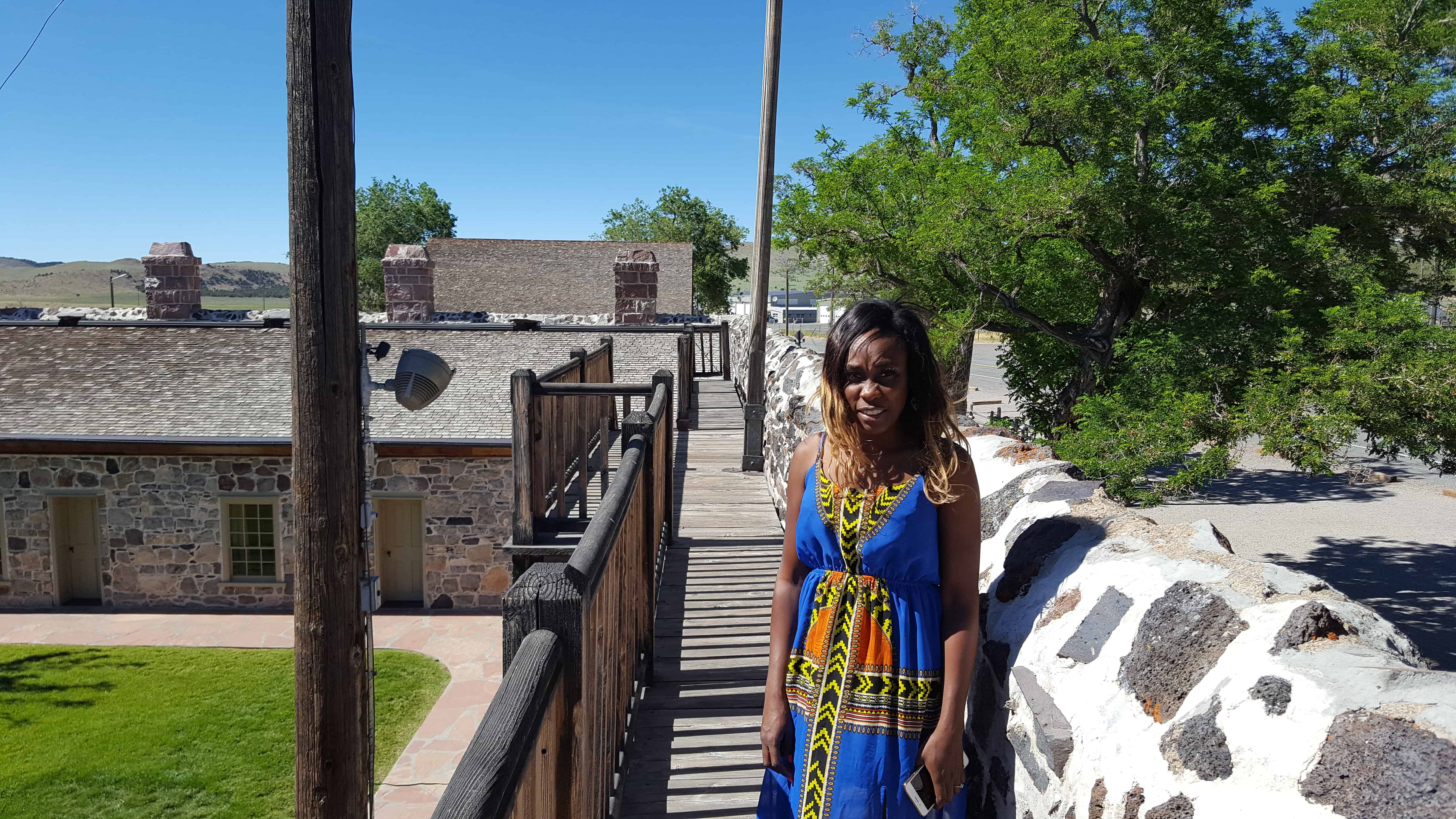
Cove Fort was built of black volcanic rock laid in with lime mortar, burned nearby. Ira N. Hinckley directed the work and was assisted by Hans Hansen, Horace Owens, James Owens, Albert Shales, Nathan Baldwin, Christian Hansen, Alien Russell, and Dorus and Orange Warner. The estimated construction cost was about $23,000.

The fort consisted of a square – – four walls 18′ high from the base of the foundation, 4′ thick at the foundation, and 2′ thick at the top, and 100′ long. The main gateway in the east wall was approximately 14′ square and closed with two large, hinged doors, originally filled with sand between the outside planking to prevent burning by flaming arrows. The west door was similarly constructed but 8′ x 4′. Six apartments (about 16′ x 14′ x 9′ ) lined each of the north and south walls, with chimneys for each room projecting 6′ above the walls. The heavy beams were hand hewn. Local timber was used for shingles and lumber.

Teams, stage coaches and covered wagons could be driven into the fort if necessary. A well was dug for water without success. However, the inhabitants felt secure when forted up.

By 1902 the fort had been abandoned and the north interior burned. Sizeable restoration efforts have been made by the Kesler family, and generally the integrity of the fort remains. Although the fabric of the walls remains excellent, there is still need for extensive restoration.

2017-03-26 14.35.03
2017-03-26 14.33.36

Completed April 12, 1867, by direction of Brigham Young, with L.D.S. Church funds, as a travelers way station and refuge from Indians. Ira N. Hinckley built and maintained it as a hostelry and residence until 1877. A well within the fort provided culinary water. Cove Creek supplied irrigation. One of its 12 original room s was used as a telegraph station. Early in 1861 Charles Willden built 3 rooms and a dugout, known as Willden’s Fort. This was a convenient campsite for President Young and other travelers.

SLC to SoCal – Cove Fort

03 Wednesday May 2017

Posted by Jacob Barlow in Uncategorized

≈ 2 Comments

Tags

Cove Fort, Historic Buildings, Historic Markers, Millard County, SLSCR, utah

2017-03-26 14.27.50

Salt Lake to Southern California Road – Cove Fort

“16th Passed over some beautiful rich bottoms covered with green grass which is uncommon at this season of the year on this route.  Passed over a high divide into a beautiful round valley [Cove Fort].  I shot the largest hare in this valley I have ever seen.  23 miles today.”  – Addison Pratt, Oct. 16, 1849.

Here is the list of “Salt Lake to Southern California Road” markers I have come across.

2017-03-26 14.28.02

Harrisburg Residents

26 Wednesday Apr 2017

Posted by Jacob Barlow in Uncategorized

≈ 1 Comment

Tags

Harrisburg, historic, Historic Buildings, Historic Homes, Historic Markers, Leeds, Silver Reef, SUP, utah, Washington, Washington County

2017-03-19 16.02.02

HARRISBURG RESIDENTS
Named here are the Heads of the Families who settled in Harrisburg between 1859 and 1928:
1859
Moses Harris
1860
James Lewis Hosea Stout
1862
William Leany Dr. Priddy Meeks John Brimhall
Orson Adams Elijah K. Fuller Samuel Hamilton
William Robb Rufus Allen Allen J. Stout
Mosiah L. Hancock Alfred J. Randall
1863
Willard G. McMullen Samuel Gould John Newton
David Ellsworth John McCleve Allen Taylor
William Taylor

1865
Henry E. Harrington Milton Daily Wilson Daily
Thomas Adair Willbur Earl William Stirling
AL Carpenter Jerome Asa
Robert Richardson Frank Owens

See other historic markers in the series on this page for SUP Markers.

Schoolhouse to Town Hall: A Building on the Move

26 Wednesday Apr 2017

Posted by Jacob Barlow in Uncategorized

≈ 1 Comment

Tags

historic, Historic Buildings, Historic Markers, Leeds, utah, Washington County

2017-03-19 15.47.44

FROM SCHOOLHOUSE TO TOWN HALL: A BUILDING ON THE MOVE

The building to your left was originally built as a schoolhouse in 1880 in nearby Silver Reef. It also served in the mining boomtown as a place for community dances and other gatherings.

Soon after the schoolhouse was built, Silver Reef began to decline in population, and by the early 1900s the building was no longer in use. At that time, the building was divided into two parts and moved on logs pulled by horses along the road, 2 miles from Silver Reef to its present site in Leeds. For more than five decades, until 1956, it served as the Leeds Schoolhouse. During most of that time, its two classrooms housed students in eight different grades.

After the school closed, the building was leased to and used by The Church of Jesus Christ of Latter-day Saints as a recreation center. Eventually it was remodeled and turned into a town hall and community gathering place for Leeds. The old school was reroofed and the small porch on the original building was expanded across the full length of the new town hall’s front.

LEEDS PEACHES: DID YOU KNOW? In the 30s, 40s, and 50s when the peach farming was booming in Leeds, peaches from the community were shipped throughout the West via rail from Cedar City. The local people working in the orchards and packing the bushel baskets with ripening peaches became curious about the cost consumer’s were paying for their peaches. So they began writing notes in the bottom of the baskets asking for people to write them back and let them know what they were paying. It was common to receive replies from as far away as Texas and Michigan. Compliments about how good the peaches tasted were often included with the replies.

2017-03-19 15.47.55
2017-03-19 15.49.15
2017-03-19 15.49.20

Bluff Fort Historic Park

23 Sunday Apr 2017

Posted by Jacob Barlow in Uncategorized

≈ 1 Comment

Tags

Bluff, Forts, historic, Historic Buildings, Historic Markers, Hole-in-the-Rock, San Juan County, utah

2017-03-12 15.26.35

The site of Bluff Fort in Bluff is full of historic buildings, plaques and plenty to learn about for hours.

Click this map from their page to go see what they have put together there:

thefort


Some of the things to see include:

Site of Kumen Jones Home – First Stone Home in Bluff

2017-03-12 15.26.49

2017-03-12 15.27.19

2017-03-12 15.27.01
2017-03-12 15.26.35
2017-03-12 15.30.08


Perkins Cabin

2017-03-12 15.27.54
2017-03-12 15.27.46
2017-03-12 15.27.41
2017-03-12 15.27.32

Lyman Cabin

2017-03-12 15.28.06
2017-03-12 15.28.14

Cabin Replicas

2017-03-12 15.28.36
2017-03-12 15.28.45
2017-03-12 15.28.47

John Taylor Monument

2017-03-12 15.29.07
2017-03-12 15.28.55

Hole-in-the-Rock Pioneers Memorial

2017-03-12 15.29.14

2017-03-12 15.29.21

Fort Montezuma

2017-03-12 15.30.36
2017-03-12 15.30.48
2017-03-12 15.30.52
2017-03-12 15.30.54
2017-03-12 15.30.59

San Juan Co-Op

2017-03-12 15.32.41

The San Juan Mission

23 Sunday Apr 2017

Posted by Jacob Barlow in Uncategorized

≈ 1 Comment

Tags

Bluff, historic, Historic Buildings, Historic Markers, Hole-in-the-Rock, San Juan County, SUP, utah

  • 2017-03-12 15.35.27

Bluff was the first settlement of the white man in San Juan County and its first county seat. It was founded April 6, 1880, by the San Juan Mission “called” by the L.D.S Church to establish friendly relations with the Indians. A small band of mission scouts found good farm land at this location in 1879 and it was resolved to settle here. Late in October 250 colonists from several southwestern Utah communities began the migration via the Hole-in-the-Rock shortcut across the Colorado River. Contrary to expectations this route proved almost impassable and after nearly six months of the most strenuous effort the exhausted company reached this site. No pioneering band ever overcame greater difficulties in establishing and maintaining a home. The turbulent river proved uncontrollable and for 40 years hostile Indians and various types of white renegades threatened both life and property. In spite of hardships and personal sacrifice the missionaries remained steadfast to their calling until released by the Church. The San Juan Mission is an unexcelled example of the highest type of Pioneer endeavor.

Erected by the National Society, Sons of Utah Pioneers – May 31, 1958
Note: This plaque is attached to a rock formation called “Sunbonnet Rock” due to its shape suggestive of a sunbonnet, and is often referred to by this name. It is located outside the Twin Rocks Café in Bluff, Utah.

This plaque is #L in the series of historic markers by the S.U.P. – See others on this page.

  • IMG_20170312_153722_489

First Latter-day Saint Chapel in Phoenix

12 Wednesday Apr 2017

Posted by Jacob Barlow in Uncategorized

≈ 2 Comments

Tags

Arizona, Arizona Historic Markers, Chapels, Churches, historic, Historic Buildings, Historic Churches, LDS Church, Maricopa County, Phoenix, SUP

2017-03-11 14.40.24

First Latter-day Saint Chapel in Phoenix

The first meetinghouse in Phoenix for The Church of Jesus Christ of Latter-day Saints (Mormons) was built on this site by the three-hundred-member congregation of the Phoenix Ward. At the time, J. Robert Price was bishop.

Since their beginning in 1912 with nine members, the Latter-day Saints in Phoenix had met in four different locations – – the Knights of Pythias Hall at 23 East Washington Street, a laundry at 534 West Washington Street, an old Spanish-style building at 121 South First Avenue, and a room over a bicycle shop at 237 North Fifth Street. They purchased this area on the eastern edge of Phoenix’s original city plat and built their first chapel 1918-1919.

The handsome meetinghouse – – designed by Pop and Burton, Architects, of Salt Lake City – – was an early example of the influence Frank Lloyd Wright’s architecture had in the Southwest. The Latter-day Saints worshipped here for nearly thirty years. Phoenix used it as a community center, and weekly businessmen’s luncheons and youth dances were held in the building.

By 1923, a thriving congregation (ward) of 730 made it necessary to expand the building; after further expansion in 1926, the meetinghouse filled this plaza area. Other wards were organized and more chapels were built, but the Phoenix First Ward continued to meet here until 1948, and Brill was completed. The building on this site was sold to another church and eventually demolished in 1969.

Bishop J. Robert Price, 1918-1926
Bishop George F. Price, 1926-1928
Bishop John H Udall, 1928-1938
Bishop Arch B. Campbell, 1938-1950

Placed 1981
Sons of Utah Pioneers, Salt River Chapter and Historic Arts and Sites Committee of The Church of Jesus Christ of Latter-day Saints

Plaque located in Heritage Square.

See other historic markers in the series on this page for SUP Markers.

2017-03-11 14.40.13

2017-03-11 14.42.06

The Carriage House

12 Wednesday Apr 2017

Posted by Jacob Barlow in Uncategorized

≈ 1 Comment

Tags

Arizona, historic, Historic Buildings, Maricopa County, Phoenix

2017-03-11 14.31.05

The Teeter Carriage House  …was built in 1899 as the mule barn for the Bouvier-Teeter House. It is typical of the traditional carriage house structure, with vehicle, animal and tack storage below, and a loft for feed above. Detached carriage houses were common before garages and carports became popular. Today the Carriage House is home to Royal Coffee Bar.

It is one of many things to see at Heritage Square.

2017-03-11 14.31.25

2017-03-11 14.30.33

Heritage Square in Phoenix

12 Wednesday Apr 2017

Posted by Jacob Barlow in Uncategorized

≈ 4 Comments

Tags

Arizona, historic, Historic Buildings, Historic Homes, Historic Markers, Maricopa County, Phoenix, SUP

2017-03-11 14.27.34

Some of the things to see here:

  • The Carriage House
  • First LDS Chapel in Phoenix
  • Rosson House

2017-03-11 14.30.12

2017-03-11 14.45.07
2017-03-11 14.45.12
2017-03-11 14.45.16

Payson Exchange Savings Bank

11 Tuesday Apr 2017

Posted by Jacob Barlow in Uncategorized

≈ 2 Comments

Tags

Banks, historic, Historic Buildings, Payson, utah

Located at 7 South Main Street in downtown Payson, Utah

The Payson Exchange Savings Bank was opened in April of 1890 in a new two-story building located on the southeast corner of Main Street and Utah Avenue.  Since the bank did not have the proper license to operate at that time, it was forced to close until the following year.  It was not granted a license to operate until January 1891.  The bank advertised that it could transact a general banking business, forward money to any part of the United States, Mexico, or Europe at the lowest possible rates.

In 1924, after more than thirty years in business, the Payson Exchange Bank failed and closed its doors.  In 1927, Payson City purchased the building and established a city office complex.  The City Library was moved from the Hancock Building located a block north of the old bank building.  The library occupied the main west portion of the bank.  The City Council Chamber was located on the second floor above the library.

The City Offices were moved from the old City Hall across the street west of the City Park to the east rooms of the bank building.  The offices had their own entrance located on Utah Avenue.  The city police and a jail were located adjacent to the city offices.  R. W. McMullin, attorney-at-law occupied the rooms above the city offices.

The bank building housed the library and city offices until the early 1980’s when they were moved to the new city complex located in the newly remodeled Payson City Hospital building located on West Utah Avenue.(*)

It is now (2017) Eli’s Old Fashioned Ice Cream and Soda Shop, an awesome place that not only has great food and ice cream but is fun to sit in and look around at the old bank vault, windows, woodwork and more.

Bank-Exchange
2017-03-08 18.27.27
2017-03-08 18.03.54
2017-03-08 18.03.27
2017-03-08 18.03.33
2017-06-14 19.11.55
(from county records)
← Older posts
Newer posts →

Follow Jacob

Follow Jacob

Come wander with me on Youtube.

Blog Stats

  • 2,103,083 hits

Social and Other Links

BarlowLinks.com

Recent Posts

  • Scout Monument
  • Provo High School Seminary Building
  • 821 E 100 S
  • 820 E 100 S
  • 817-819 E 100 S

Archives

Loading Comments...