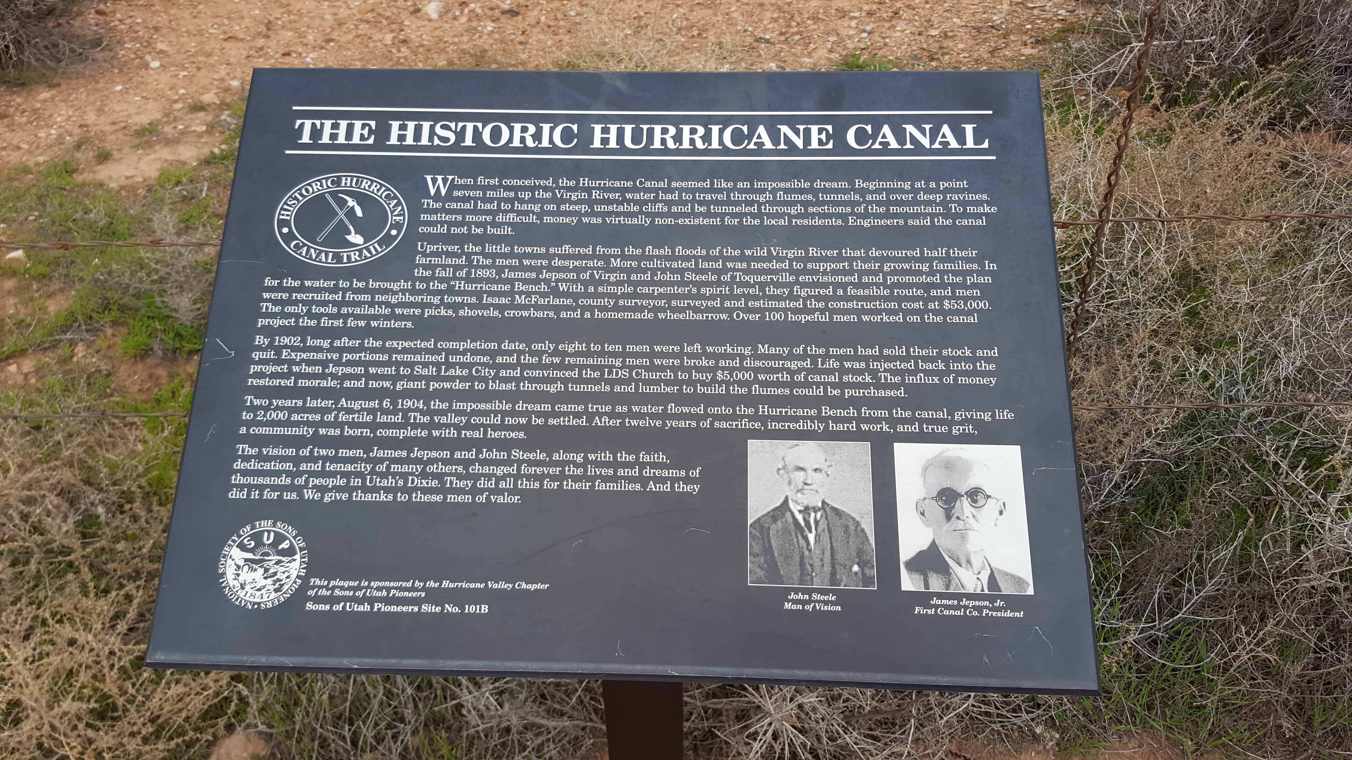
When first conceived, the Hurricane Canal seemed like an impossible dream. Beginning at a point seven miles up the Virgin River, water had to travel through flumes, tunnels, and over deep ravines. The canal had to hang on steep, unstable cliffs and be tunneled through sections of mountain. To make matters more difficult, money was virtually non-existent for the local residents. Engineers said the canal could not be built.
Upriver, the little towns suffered from the flash floods of the wild Virgin River that devoured half their farmland. The men were desperate. More cultivated land was needed to support their growing families. In the fall of 1893, James Jepson of Virgin and John Steele of Toquierville envisioned and promoted the plan for the water to be brought to the “Hurricane Bench.” With a simple carpenter’s spirit level, they figured a feasible route, and men were recruited from neighboring towns. Isaac McFarlane, county surveyor, surveyed and estimated the construction cost at $53,000. The only tools available were picks, shovels, crowbars, and a homemade wheelbarrow. Over 100 hopeful me worked on the canal project the first few winters.
By 1902, long after the expected completion date, only eight to ten men were left working. Many of the men had sold their stock and quit. Expensive portions remained undone, and the few remaining men were broke and discouraged. Life was injected back into the project when Jepson went to Salt Lake City and convinced the LDS Church to buy $5,000 worth of canal stock. The influx of money restored morale; and now, giant powder to blast through tunnels and lumber to build the flumes could be purchased.
Two years later, August 6, 1904, the impossible dream came true as water flowed onto the Hurricane Bench from the canal, giving life to 2,000 acres of fertile land. The valley could now be settled. After twelve years of sacrifice, incredibly hard work, and true grit, a community was born, complete with real heroes.
The vision of two men, James Jepson and John Steele, along with the faith, dedication, and tenacity of many others, changed forever the lives and dreams of thousands of people in Utah’s Dixie. They did all this for their families. And they did it for us. We give thanks to these men of valor.
See other historic markers in the series on this page for SUP Markers.
In 1858, Nephi Johnson, one of Brigham Young’s scouts, with a party of Indian guides arrived at the mouth of the canyon. Due to superstition, the Indians refused to enter the canyon. Nephi Johnson, alone, followed up river to the Narrows, a place “where the sun is seldom seen,” returning to the mouth at nightfall. Isaac Buhannin, an early settler, seeing the spires remarked, “surely this is God’s first temple and should be called Zion.” William Heaps helped to build homes for the early settlers in the canyon.
Silver Reef is a “ghost town” in Washington County, near Leeds. Silver Reef was established after John Kemple, a prospector from Nevada, discovered a vein of silver in a sandstone formation in 1866. At first, geologists were uncertain about Kemple’s find because silver is not usually found in sandstone. In 1875, two bankers from Salt Lake City sent William Barbee to the site to stake mining claims. He staked 21 claims, and an influx of miners came to work Barbee’s claims and to stake their own. To accommodate the miners, Barbee established a town called Bonanza City. Property values there were high, so several miners settled on a ridge to the north of it and named their settlement “Rockpile”. The town was renamed Silver Reef after silver mines in nearby Pioche closed and businessmen arrived.
By 1879, about 2,000 people were living in Silver Reef. The town had a mile-long Main Street with many businesses, among them a Wells Fargo office, the Rice Building, and the Cosmopolitan Restaurant. Although adjacent to many settlements with a majority of Mormon residents, the town never had a meeting house for Latter-day Saints, only a Catholic church. In 1879, a fire destroyed several businesses, but the residents rebuilt them. Mines were gradually closed, most of them by 1884, as the worldwide price of silver dropped. By 1901, most of the buildings in town had either been demolished or moved to Leeds.
In 1916, mining operations in Silver Reef resumed under the direction of Alex Colbath, who organized the area’s mines into the Silver Reef Consolidated Mining Company. These mines were purchased by American Smelting and Refining Company in 1928, but the company did minimal work as a result of the Great Depression. The Western Gold & Uranium Corporation purchased Silver Reef’s mines in 1948, and in 1951, they began mining uranium in the area. These operations did not last long either, and the Western Gold & Uranium Corporation sold their mines to the 5M Corporation in 1979. Today, the Wells Fargo office, the Cosmopolitan Restaurant, the Rice Building, and numerous foundations and walls remain in the town site, and a few dozen homes have been constructed in the area.(*)
Between 1875 and the end of 1876, Silver Reef boomed with development, going from a boulder-strewn flat to a town of 1,500 people, one of the largest in Washington county. Silver Reef soon became the center of permanent development, and many stone and wooden buildings were erected along a mile-long Main Street. Among the many businesses and buildings were six saloons, nine grocery stores, two dance halls, a brewery, billiard hall, the Wells Fargo Express Office, post office undertaker, citizens hall, jail, Masonic and Oddfellows halls, telegraph office, barber shop, physicians office, Chinese laundries (the walls are standing today), and a Catholic church with a hospital included. The Wells Fargo building, which you stand before, has been placed on the National Register of Historic Places.
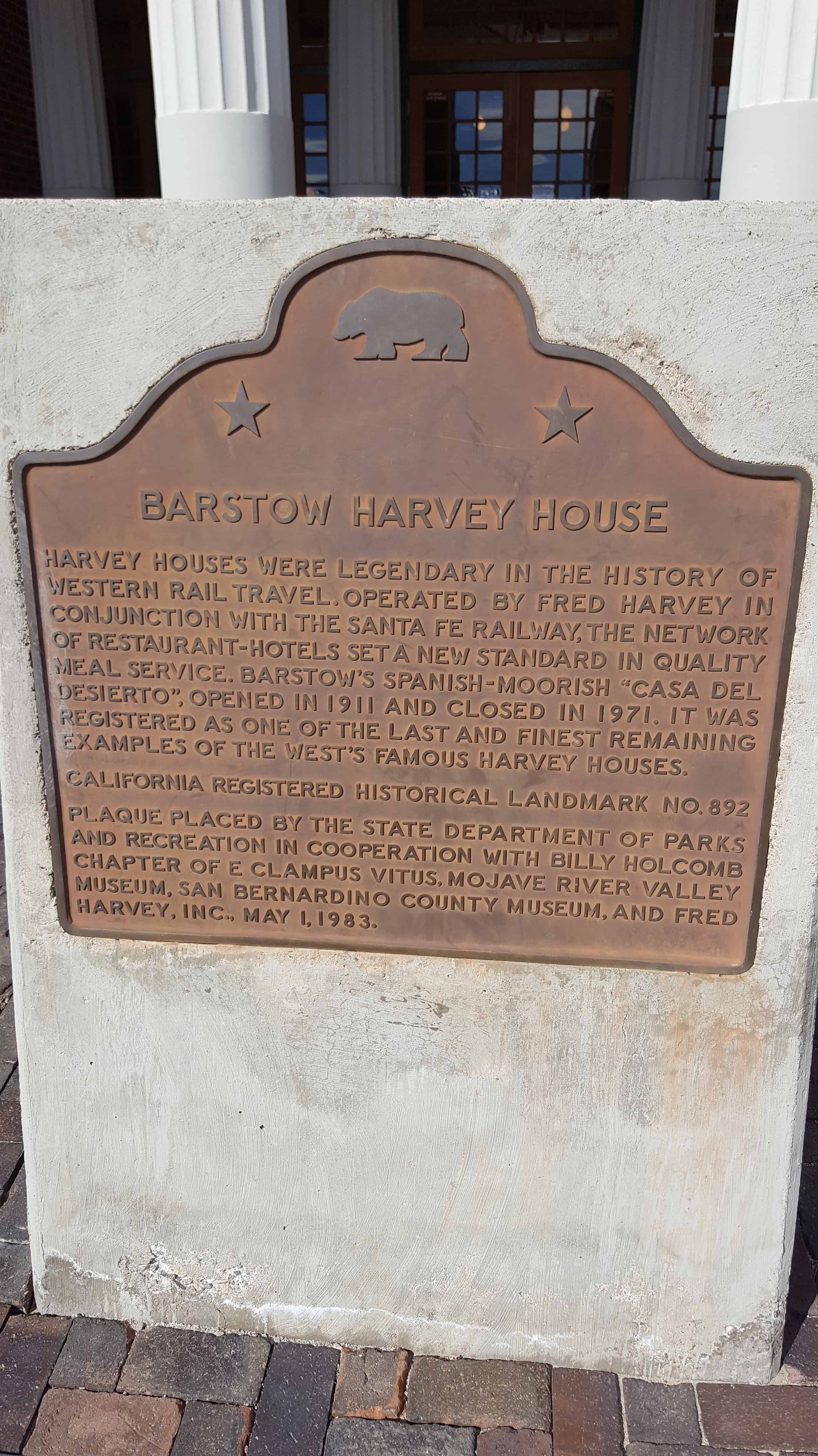
Harvey Houses were legendary in the history of Western rail travel. Operated by Fred Harvey in conjunction with this Santa Fe Railway, the network of restaurant-hotels set a new standard in quality meal service. Barstow‘s Spanish-Moorish “Casa Del Desierto” opened in 1911 and closed in 1971. It was registered as one of the last and finest remaining examples of the West’s famous Harvey Houses.
Marl Springs was named in 1854 by Army Surveyor Lt. Amiel Whipple for the clay-like soil around the two waterholes. With the establishment of Fort Mojave in 1859, the Mojave (or Old Government) Road came into existence. Marl Springs became an important stop over being more than 30 miles eastward from the last dependable water Soda Springs (now Zzyzx). Though never abundant, the water here has always been reliable. In the fall of 1867 the springs were garrisoned by soldiers of Company K, 14th U.S. Infantry, who escorted supply trains and guarded the mail. On October 17, 1867, the post, manned by three soldiers, was attacked by a group of 20 to 30 Indians. The defenders held out through the night and the siege was lifted the next morning when a column of 150 soldiers appeared on the horizon. The outpost was abandoned in May, 1868. Marl Springs has been witness to sporadic mining and milling operations over the years and continues to serve local wildlife and cattle ranchers. Marl Springs is located approximately 25 miles east of here.
In 1859 the U.S. Army established Fort Mojave on the east bank of the Colorado north of Needles to guard the important river crossing at the Mojave Villages. The Mojave (or Old Government) Road came into being to link the fort with the Port of Los Angeles. Supplies, troops, and mail traveled over this route, with many heavy wagons traveling eastward. The portion from Soda Springs (now Zzyzx) to Marl Springs was approximately 35 miles, the longest waterless stretch on the trail. It also gained 3,000 feet in elevation over this distance, much of the way over deep, soft sand. This northern-most spur of Old Dad Mountain, midway between the two waterholes, was known as Seventeenmile Point. In an attempt to avoid the worst of the desert heat, heavily laden supply wagons would typically leave Soda Springs at night, make a dry camp nearby, and continue on the next day to the dependable water at Marl Springs. Seventeen mile point is located approximately twelve miles east of here.
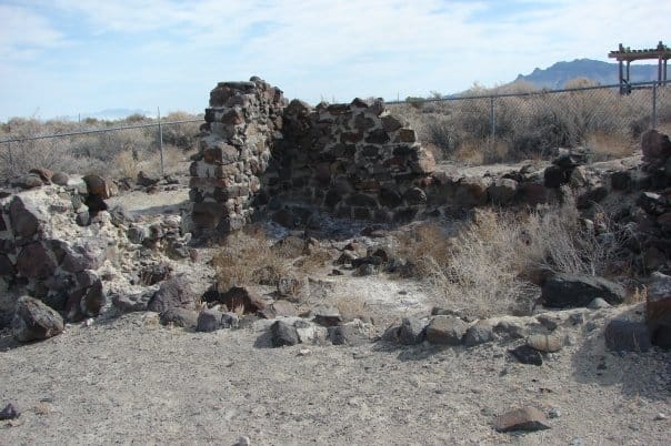
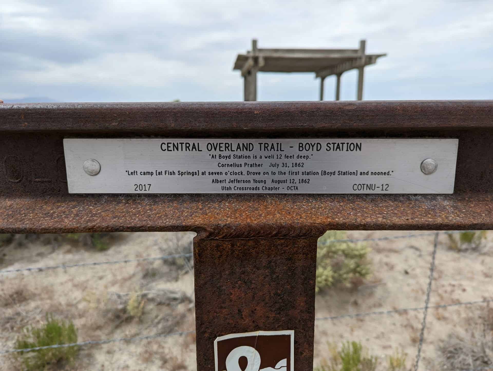
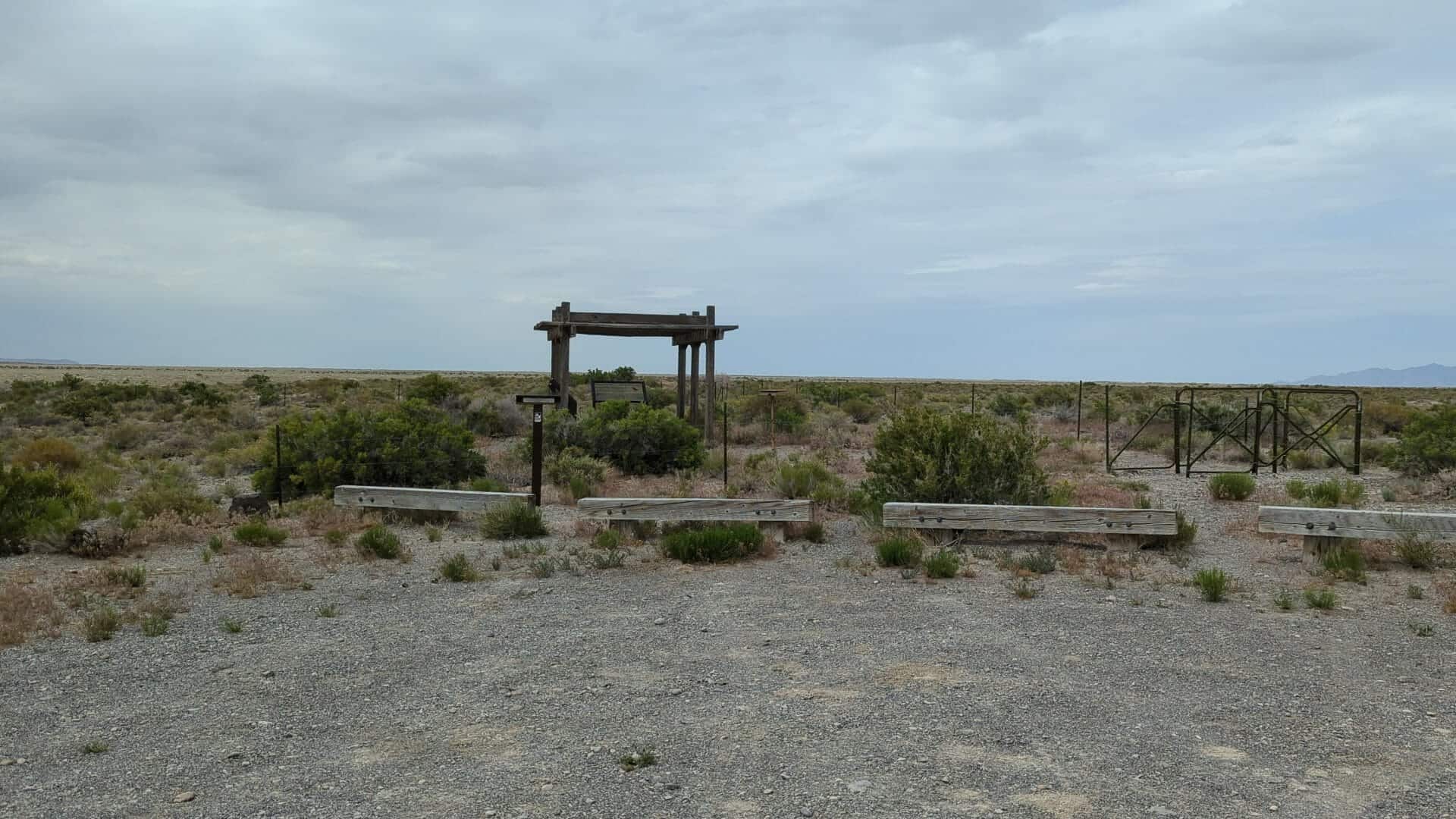
Boyd Station Also known as, Desert Station, Boyd’s Station and Boyd’s Half-Way House
There is a very well preserved ruin of the station located here, fenced off and maintained by the BLM. The station was named for George Washington Boyd who built it in 1855 and lived there until after 1900, reportedly enjoying the solitude. He died in Salt Lake City in 1903.
This location is the site of Utah Pioneer Trails and Landmarks Association historic marker #92 which is no longer here (I did see a picture of the plaque in a museum and would like to find out where it is) and also Utah Crossroads Chapter – OCTA’s historic marker #COTNU-12.
“Left camp [at Fish Springs] at seven o’clock. Drove on to the first station [Boyd Station] and nooned.”
Albert Jefferson Young, August 12, 1862
Unsung Heroes
Strategically placed relay stations across the western frontier proved to be a major contributing factor to the early success of the Pony Express mail service. “Station Keepers” assigned to these outposts readied swift horses, fresh and rested, for each rider. Often working in pairs, day and night they kept a vigil for incoming riders.
Life for the brave men at these station covered a broad spectrum of living conditions depending upon location and situation. Home station were generally better established and more accommodating, even luxurious by some standards. Remote relay stations, especially in the West, were often exceedingly primitive.
In St. Joseph, Missouri, Patee House was one of the most luxurious hostelries on the frontier. This four story brick building, which is still standing, was well known for its social life and gala balls and parties. Smith Hotel in Seneca, KS, and the Salt Lake House in Utah, were other prominent hotels which served as comfortable home stations for riders and company personnel.
West of Salt Lake City and across the Great Basin to California, accommodations and quality of life tended to go downhill. Hot, dry summers and bitter, cold winters often were the only companions for station keepers. On other days, loneliness and idle time were interlaced by fending off horse thieves and Indian attacks. Frequently exposed to danger, many lost their lives in this daring American enterprise.
Though the Pony Express has become a romanticized legend in American history, the station keepers – those who kept the horse waiting and bid “Godspeed” to the rider as he galloped away – are the true unsung heroes of the Pony Express.
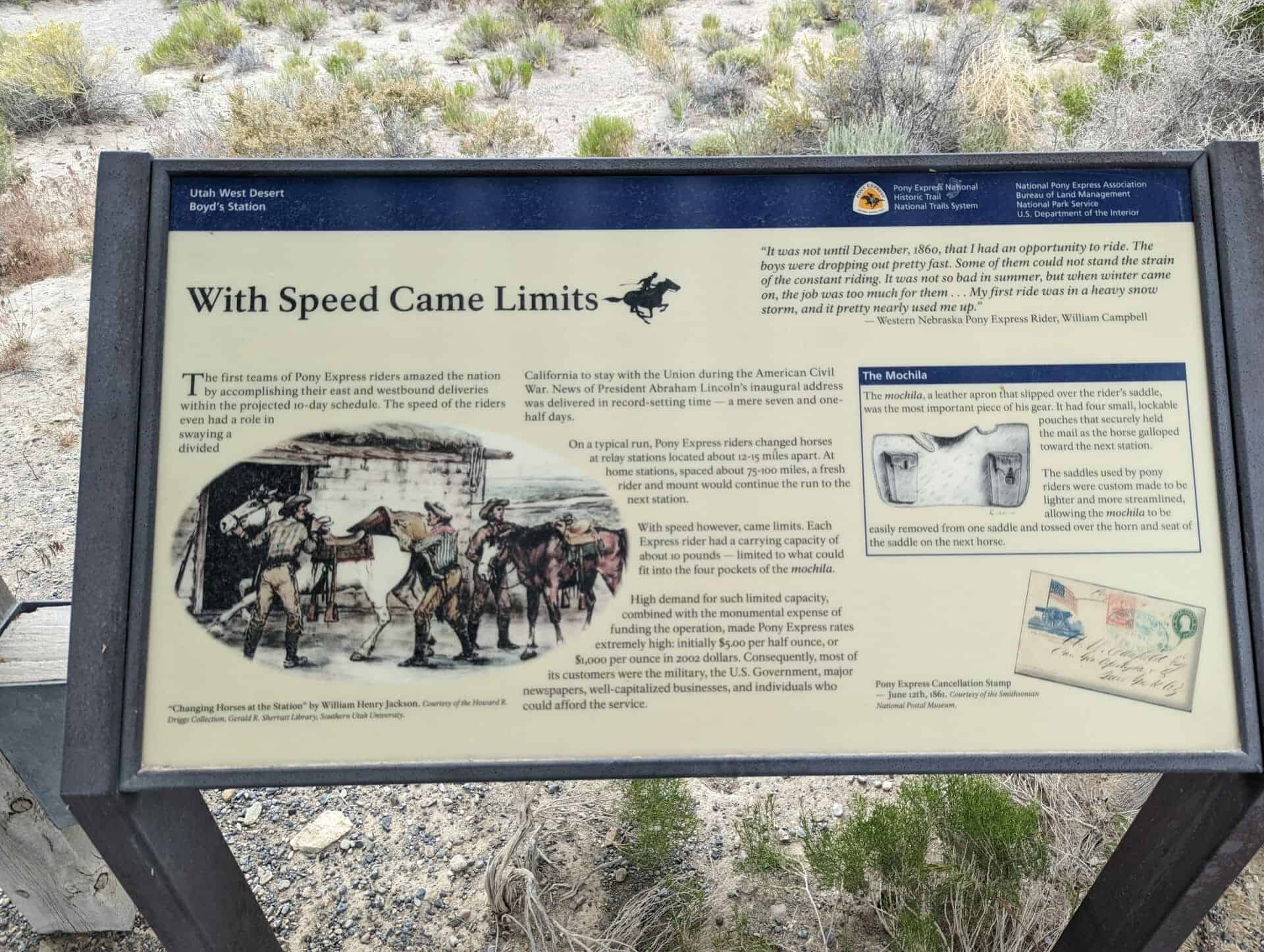
With Speed Came Limits
The first teams of Pony Express riders amazed the nation by accomplishing their east and westbound deliveries within the projected 10-day schedule. The speed of the riders even had a role in swaying a divided California to stay with the Union during the American Civil War. News of President Abraham Lincoln’s inaugural address was delivered in record-setting time – a new seven and one-half days.
On a typical run, Pony Express riders changed horses at relay stations located about 12-15 miles apart. At home stations, spaced about 75-100 miles, a fresh rider and mount would continue the run to the next station.
With speed however, came limits. Each Express rider had a carrying capacity of about 10 pounds – limited to what could fit into the four pockets of the mochila.
High demand for such limited capacity, combined with the monumental expense of finding the operation, made Pony Express rates extremely high: initially $5.00 per half ounce, or $1,000 per ounce in 2002 dollars. Consequently, most of its customers were the military, the U. S. Government, major newspapers, well-capitalized businesses, and individuals who could afford the service.
“It was not until December, 1860, that I had an opportunity to ride. The boys were dropping out pretty fast. Some of them could not stand the strain of the constant riding. It was not so bad in summer, but when winter came on, the job was too much for them. . . My first ride was in a heavy snow storm, and it pretty nearly used me up.” – Western Nebraska Pony Express Rider, William Campbell
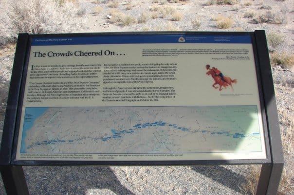
The Crowds Cheered On…
In 1845, it took six months to get a message from the east coast of the United States to California. By the time it arrived, the news was old. In the late 1850s, a half million people had migrated west, and they wanted up-to-date news from home. Something had to be done to deliver mail faster and to improve communication in the expanding nation.
“The Central Overland California and Pikes Peak Express Company,” a subsidiary of Russell, Majors, and Waddell, announced the formation of the Pony Express on January 27, 1860. They planned to carry letter mail between St. Joseph, Missouri and Sacramento, California in only ten days. Although the Pony Express was a financially risky enterprise, the company hoped to attract a lucrative contract with the U.S. Postal Service.
Knowing that a healthy horse could run at a full gallop for only 10 to 12 miles, the Pony Express needed stations for its riders to change mounts. They utilized existing stage stations on the eastern end of the route, but needed to build many new station in remote areas across the Great Basin. Alexander Majors said that 400 to 500 mustang horses were purchased, 200 men were hired to manage the station, and 80 riders signed on to begin the run of the Pony Express.
Although the Pony Express captured the admiration, imagination, and hearts of people, it was a financial disaster for its founders. The Pony era, however, was not brought to an end by its financial failure, weather, or even problems with Indians – but by the completion of the Transcontinental Telegraph on October 26, 1861.
“Every neck is stretched, and every eye stained… Across the endless prairie a black spec appears… In a second or two it becomes a horse and rider, rising and falling, rising and falling – sweeping toward us – growing more and more distinct, and the flutter of hoofs comes faintly to the ear – another instant a whoop and a hurrah from our upper deck, a wave of the rider’s hand, but no reply, and man and horse burst past our excited faces, and go winging away like belated fragment of a storm.” – Mark Twain – Roughing It, 1872.
This is the last summit in the Wasatch Mountains along the pioneer trail. From this point the trail descends northwest until it reaches Emigration Creek. As William Clayton’s emigrants guide warns, “The descent is very steep all the way.”
The Donner Party passed over the summit August 21, 1846 and the Mormons on July 21, 1847.
Note: This monument was refurbished by the Salt Lake City Chapter SUP and dedicated on July 21, 2015 as SUP monument #187. The plaque indicates a dedication date of May 2015 – however the dedication was delayed due to considerable rain during May and June.
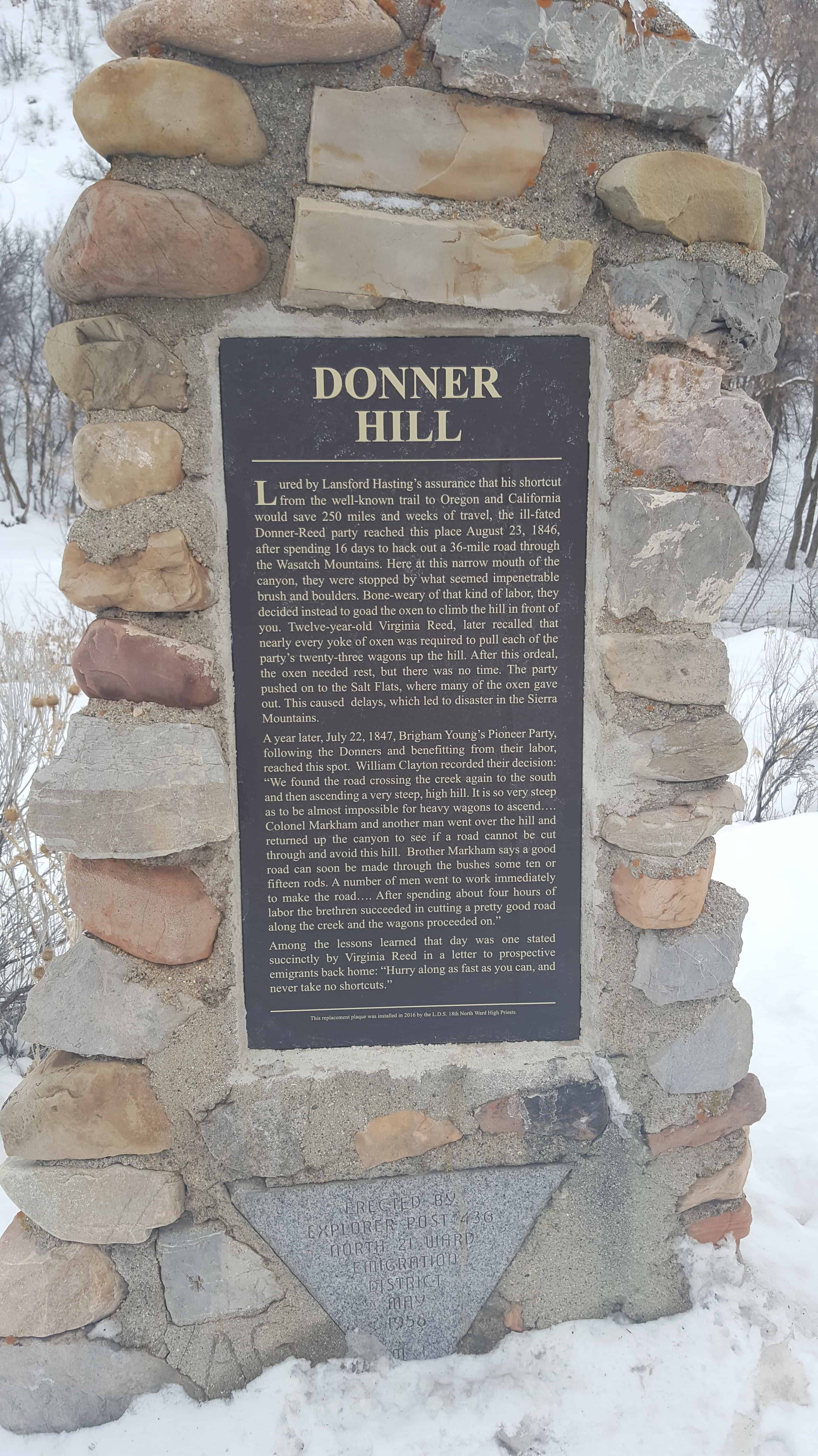
Lured by Lansford Hasting’s assurance that his shortcut from the well-known trail to Oregon and California would save 250 miles and weeks of travel, the ill-fated Donner-Reed party reached this place August 23, 1846, after spending 16 days to hack out a 36 mile road through the Wasatch Mountains. Here at this narrow mouth of the canyon, they were stopped by what seemed impenetrable brush and boulders. Bone-weary of that kind of labor, they decided instead to goad the oxen to climb the hill in front of you. Twelve-year-old Virginia Reed, later recalled that nearly every yoke of oxen was required to pull each of the party’s twenty-three wagons up the hill. After this ordeal, the oxen needed rest, but there was no time. The party pushed on to the Salt Flats, where many oxen gave out. This caused delays, which let to disaster in the Sierra Mountains.
A year later, July 22, 1847, Brigham Young’s Pioneer Party, following the Donners and benefiting from their labor, reached this spot. William Clayton recorded their decision: “We found the road crossing the creek again to the south and then ascending a very steep, high hill. It is so very steep as to be almost impossible for heavy wagons to ascend…. Colonel Markham and another man went over the hill and returned up the canyon to see if a road cannot be cut through and avoid this hill. Brother Markham says a good road can soon be made through the bushes some ten or fifteen rods. A number of men went to work immediately to make the road…. After spending about four hours of labor the brethren succeeded in cutting a pretty good road along the creek and the wagons proceeded on.”
Among the lessons learned that day was one stated succinctly by Virginia Reed in a letter to prospective emigrants back home: “Hurry along as fast as you can, and never take no shortcuts.”
Sometime around 2010 the plaque here was stolen, I drive by often and was pleasantly surprised to see a new one in 2016.
Here’s the original (photos not by me, but by my friend Rick Scheve.
DONNER HILL After 4 1/2 miles of fighting boulders and brush along stream bed Donner Party gave up here and on August 22, 1846 climbed steep hill to southwest. A survivor wrote, “We doubled teams, almost every yoke in the train (of 23 wagons) being required to pull up each wagon.” Mormon Pioneers a year later built road through to mouth of canyon with 4 hours labor. Erected by “Mormon” Explorers Y M M I A
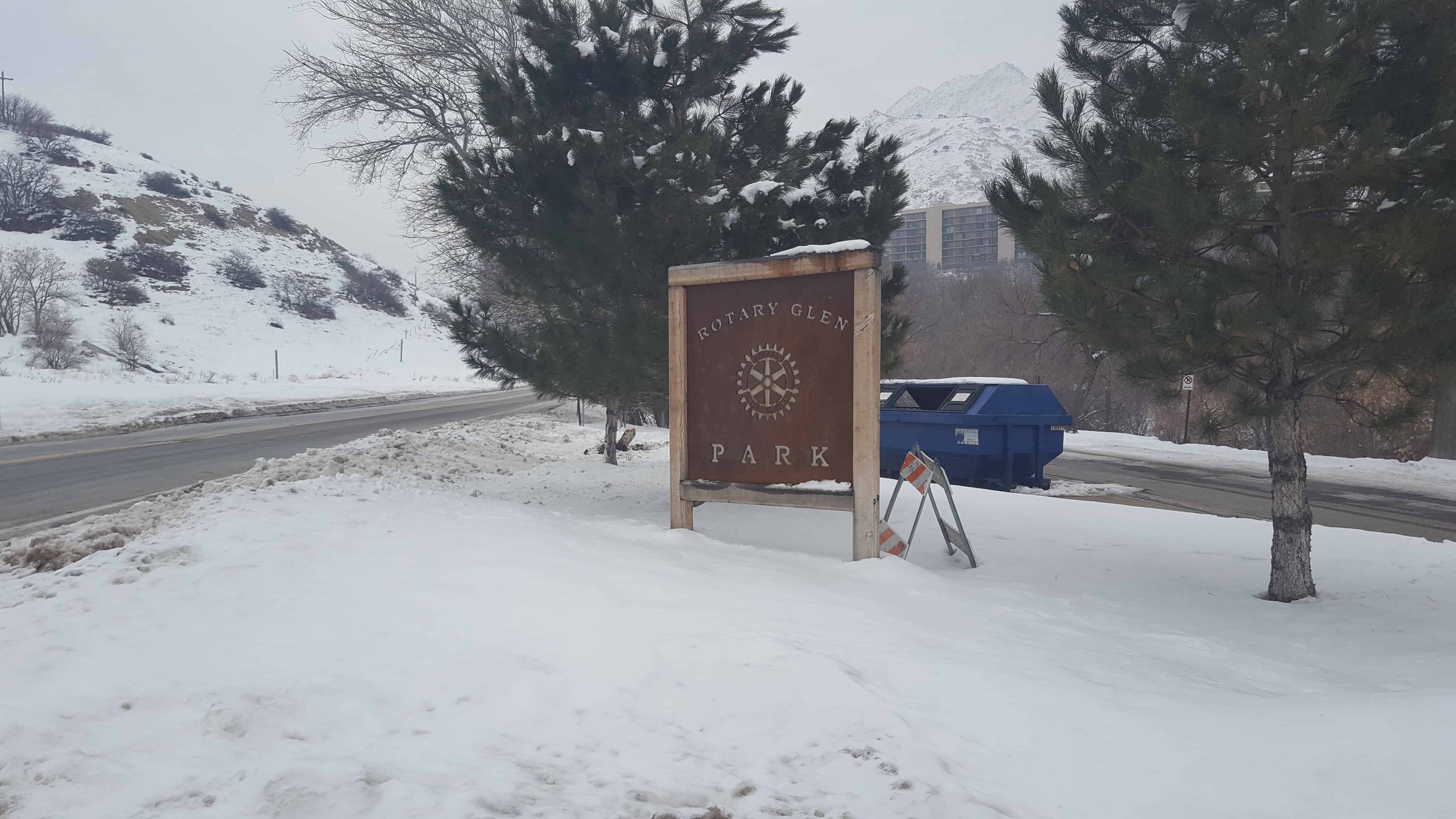
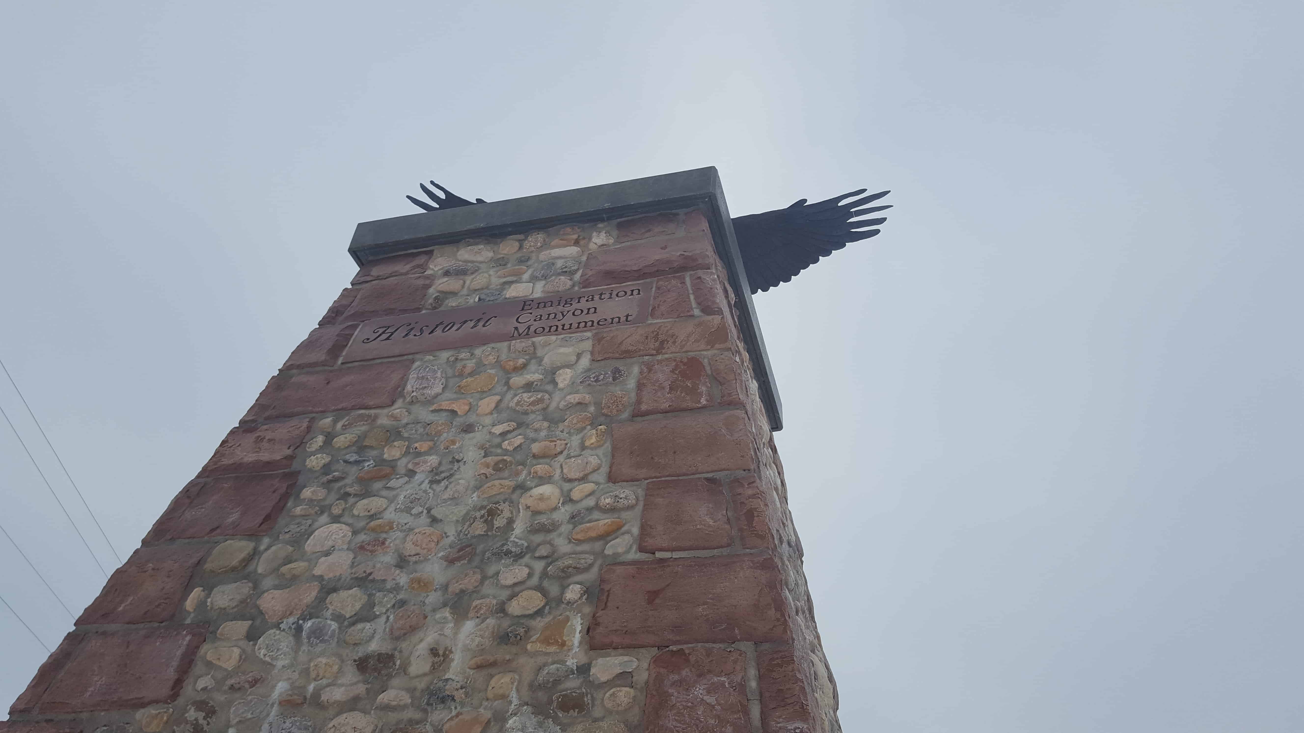
Sponsors: Sugar House Chapter Sons of Utah Pioneers and Emigration Canyon Historical Society, 2012 Location: Mouth of Emigration – Rotary Glen Park There are five plaques associated with this monument:
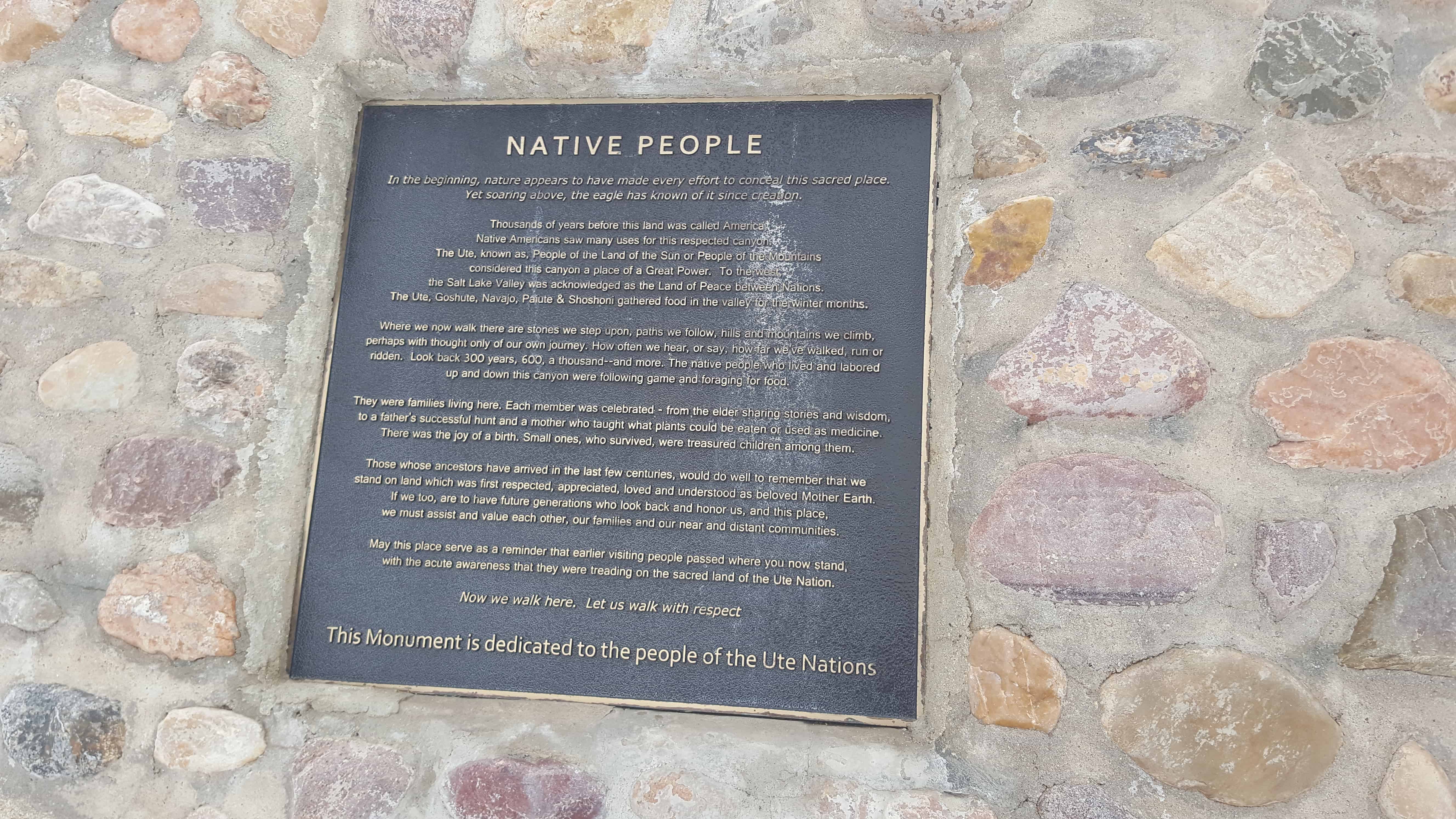
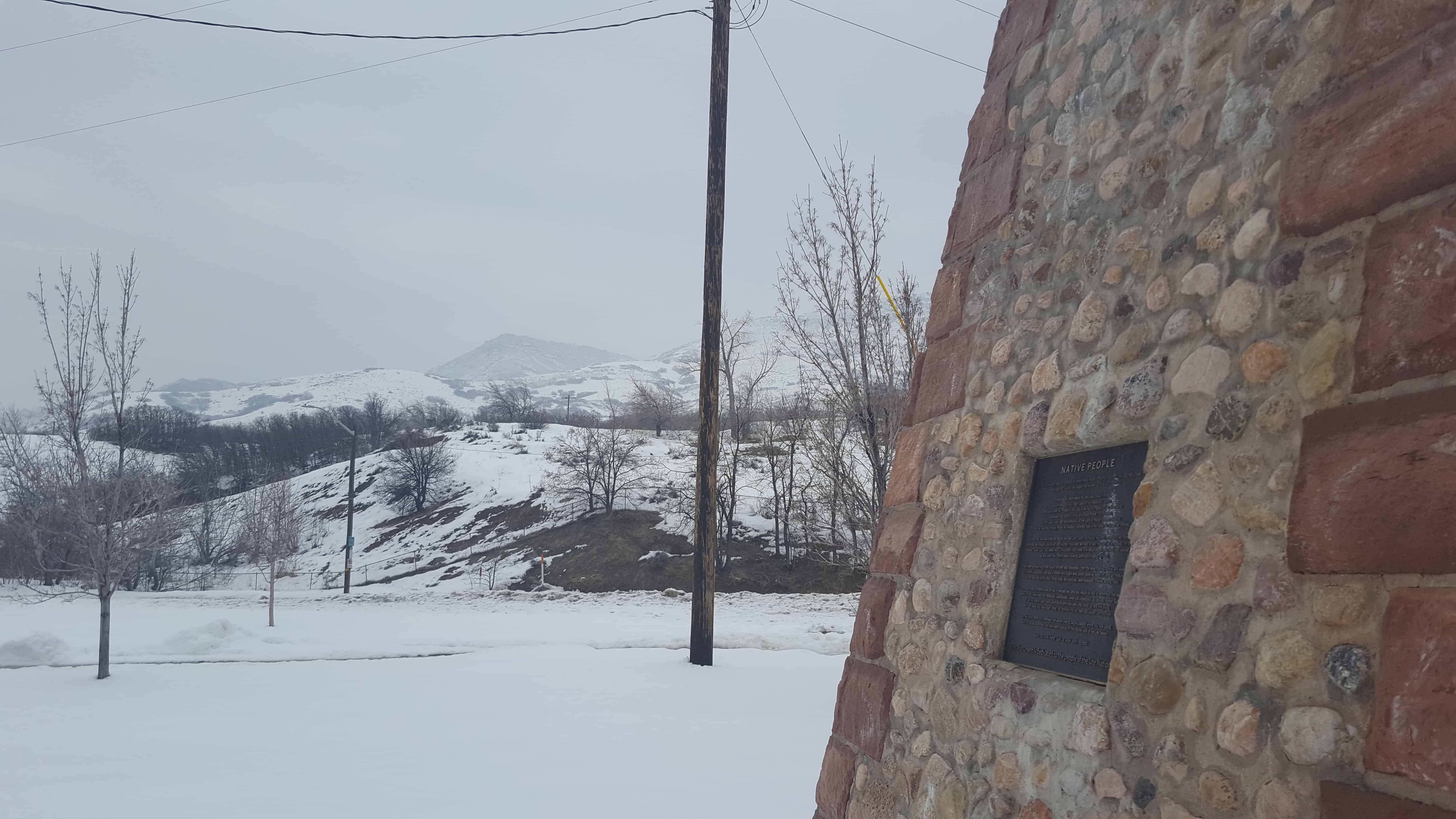
Native People
In the beginning, nature appears to have made every effort to conceal this sacred place. Yet soaring above, the eagle has known of it since creation. Thousands of years before this land was called America, Native Americans saw many uses for this respected canyon. The Ute, known as, People of the Land of the Sun or People of the Mountains considered this canyon a place of Great Power. To the west, the Salt Lake Valley was acknowledged as the Land of Peace between Nations. The Ute, Goshute, Navajo, Paiute & Shoshoni gathered food in the valley for the winter months. Where we now walk there are stones we step upon, paths we follow, hills and mountains we climb, perhaps with thought only of our own journey. How often we hear, or say, how far we’ve walked, run or ridden. Look back 300 years, 600, a thousand – and more. The native people who lived and labored up and down this canyon were following game and foraging for food. They were families living here. Each member was celebrated – from the elder sharing stories and wisdom, to a father’s successful hunt and a mother who taught what plants could be eaten or used as medicine. There was the joy of a birth. Small ones, who survived, were treasured children among them. Those whose ancestors have arrived in the last few centuries, would do well to remember that we stand on land which was first respected, appreciated, loved and understood as beloved Mother Earth. If we too, are to have future generations who look back and honor us, and this place, we must assist and value each other, our families and our near and distant communities. May this place serve as a reminder that earlier visiting people passed where you now stand, with the acute awareness that they were treading on the sacred land of the Ute Nation. Now we walk here. Let us walk with respect This Monument is dedicated to the people of the Ute Nations
See other historic markers in the series on this page for SUP Markers.
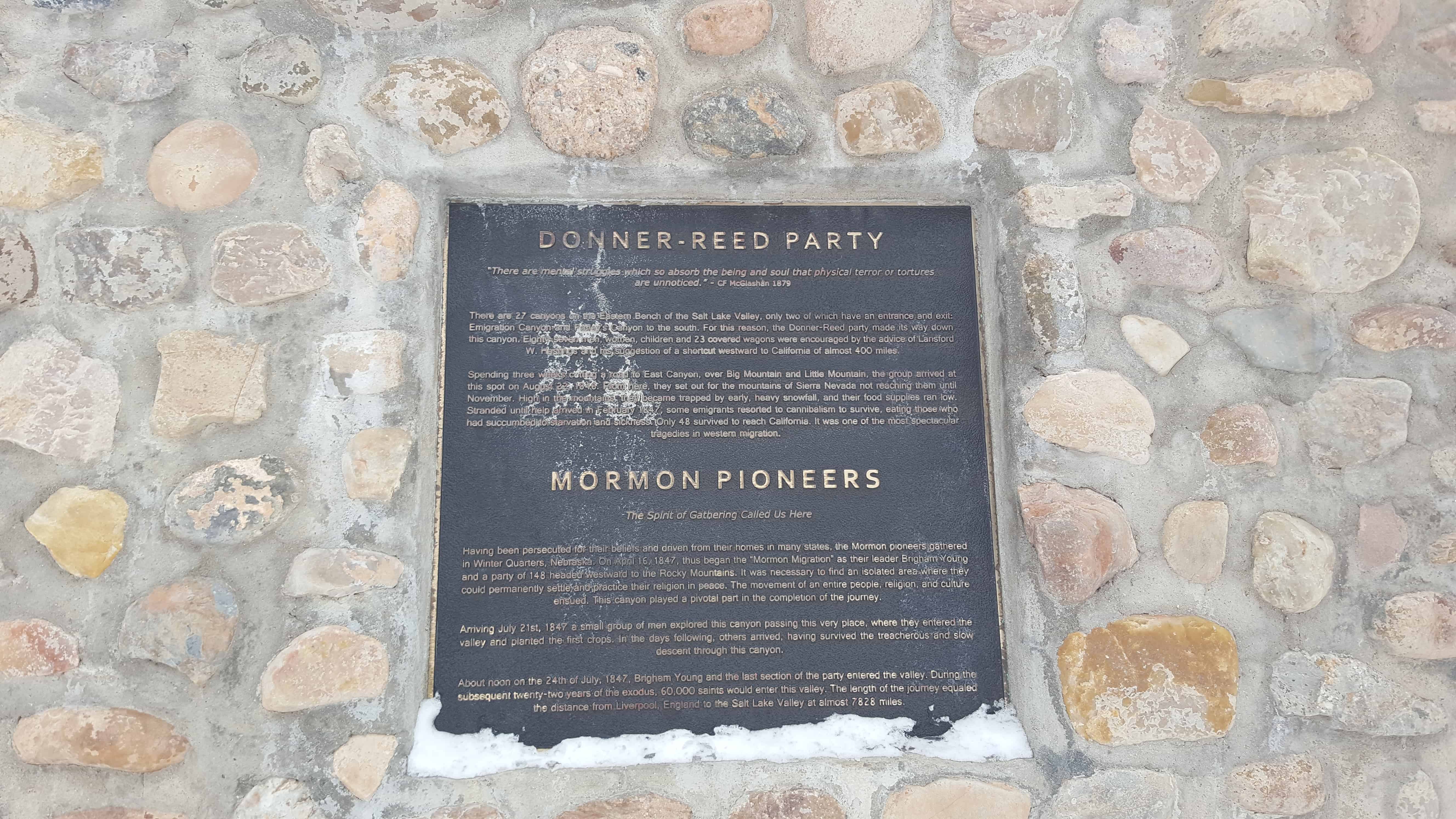
DONNER-REED PARTY
“There are mental struggles which so absorb the being and soul that physical terror or tortures are unnoticed.” – C F McGlashan 1879 There are 27 canyons on the Eastern Bench of the Salt Lake Valley. Only two of which have an entrance and exit: Emigration Canyon and Parley’s Canyon to the south. For this reason, the Donner-Reed party made its way down this canyon. Eighty-seven men, women, children and 23 covered wagons were encouraged by the advice of Lansford W. Hastings and his suggestion of a shortcut westward to California of almost 400 miles. Spending three weeks cutting a road to East Canyon, over Big Mountain and Little Mountain, the group arrived at this spot on August 22, 1846. From here, they set out for the mountains of Sierra Nevada not reaching them until November. High in the mountains, they became trapped by early, heavy snowfall, and their food supplies ran low. Stranded until help arrived in February 1847, some emigrants resorted to cannibalism to survive, eating those who had succumbed to starvation and sickness. Only 48 survived to reach California. It was one of the most spectacular tragedies in western migration.
MORMON PIONEERS The Spirit of Gathering Called Us Here
Having been persecuted for their beliefs and driven from their homes in many states, the Mormon pioneers gathered in Winter Quarters, Nebraska. On April 16, 1847, thus began the “Mormon Migration” as their leader Brigham Young and a party of 148 headed westward to the Rocky Mountains. It was necessary to find an isolated area where they could permanently settle and practice their religion in peace. The movement of an entire people, religion, and culture ensued. This canyon played a pivotal part in the completion of the journey. Arriving July 21, 1847 a small group of men explored this canyon passing this very place, where they entered the valley and planted the first crops. In the days following, others arrived, having survived the treacherous and slow decent through this canyon. About noon on the 24th of July, 1847, Brigham Young and the last section of the party entered the valley. During the subsequent twenty-two years of the exodus, 60,000 saints would enter this valley. The length of the journey equaled the distance from Liverpool, England to the Salt Lake Valley at almost 7828 miles.
EXPLORERS – TRAPPERS – TRADERS
Only Native Indians inhabited what is now Utah prior to the 1700s. The exploring party of Escalante and Dominquez traveled 1800 miles to arrive to the south at Utah Lake in 1776, but never entered the Salt Lake Valley. This Great Basin area was first claimed by the Spanish as a Mexican Territory until the Mexican War (1846-1848). In the 1820s and 1830s, Mountain Men and Trappers led lives that were dangerous and often down right miserable. Some ended in attacks by Natives or grizzly bears. But, during their short time here, many explored the canyons and surrounding areas. Among the first white traders along this Wasatch Range was Etienne Provost known as the “Man of the Mountains”. Jim Bridger reached this basin too by traveling in a bull boat along what he thought was an arm of the Pacific Ocean because of the Great Salt Lake’s salinity. Other notables were Jedediah Smith, Thomas “Broken Hand” Fitzpatrick, Morris “Black” Harris, and Milton and William Sublete, as well as many others. In 1843, explorer John C. Fremont made a great contribution with his detailed book on this canyon and the Great Basin. Accompanying him were Kit Carson, Tom Fitzpatrick and mapmaker Charles Preuss. In 1849, Howard Stansbury surveyed this area again. “Emigration is a gate to the Salt Lake Valley, veiled in obscurity, and unknown to the citizens of the United States” – Solomon Carvalho 1852
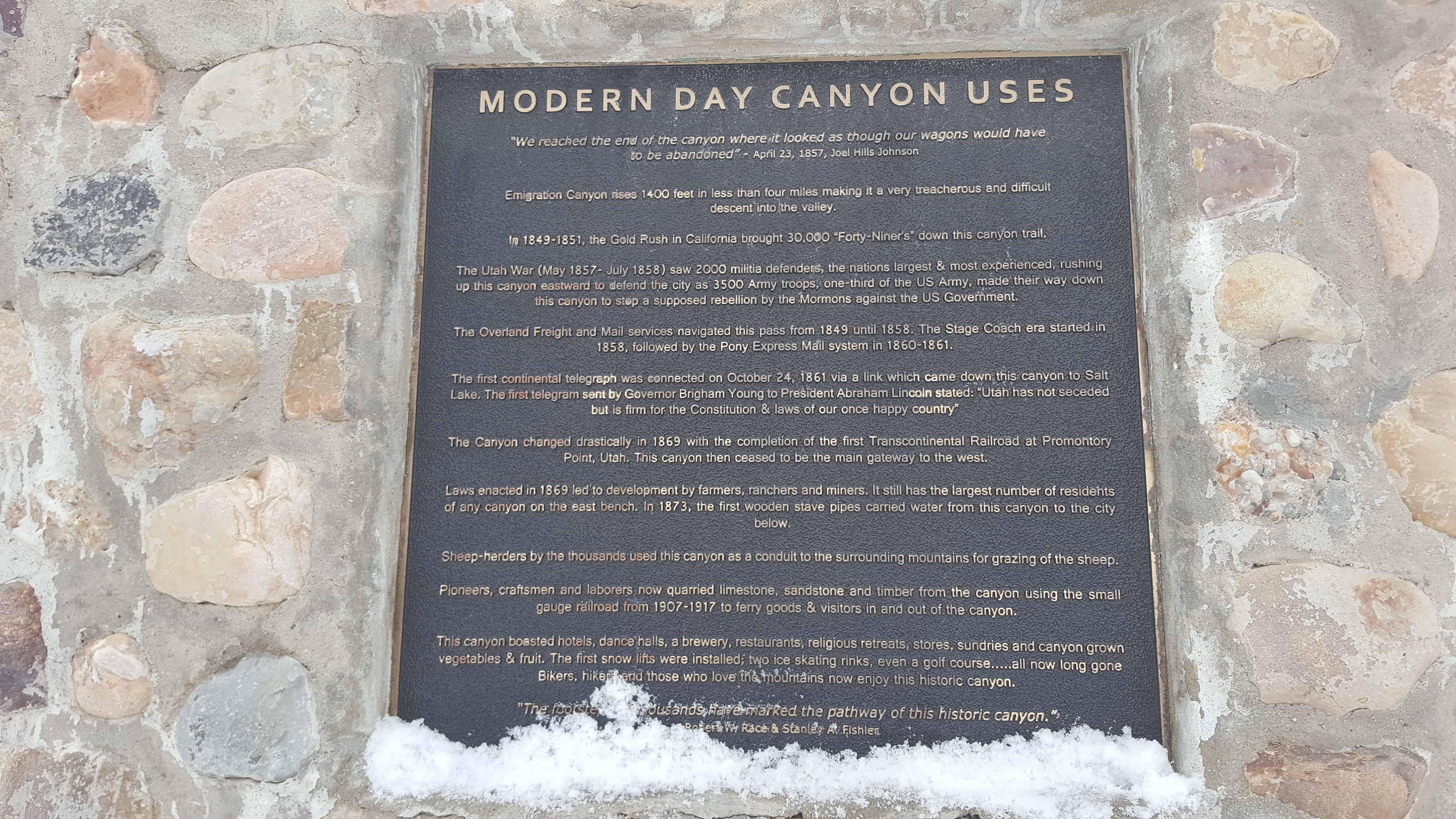
MODERN DAY CANYON USES
“We reached the end of the canyon where it looked as though our wagons would have to be abandoned” – April 23, 1857, Joel Hills Johnson Emigration Canyon rises 1400 feet in less than four miles making it a very treacherous and difficult descent into the valley. In 1849-1851, the Gold Rush in California brought 30,000 “Forty-Niners” down this canyon trail. Utah War (May 1857-July 1858) saw 2000 militia defenders, the nations largest & most experienced, rushing up this canyon eastward to defend the city as 3500 Army troops, one third of the US Army, made their way down this canyon to stop a supposed rebellion by the Mormons against the US Government. The Overland Freight and Mail services navigated this pass from 1849 until 1858. The Stage Coach era started in 1858, followed by the Pony Express Mail system in 1860-1861. The first continental telegraph was connected on October 24, 1861 via a link which came down this canyon to Salt Lake. The first telegram sent by Governor Brigham Young to President Abraham Lincoln stated: “Utah has not seceded but is firm for the Constitution & laws of our once happy country” The Canyon changed drastically in 1869 with the completion of the first Transcontinental Railroad at Promontory Point, Utah. This canyon then ceased to be the main gateway to the west. (Note: The rail lines were joined at Promontory Summit, Utah, 50-miles north of Promontory Point, Utah.)
Laws enacted in 1869 led to development by farmers, ranchers and miners. It still has the largest number of residents of any canyon on the east bench. In 1873, the first wooden stave pipes carried water from this canyon to the city below. Sheep-herders by the thousands used this canyon as a conduit to the surrounding mountains for grazing of the sheep. Pioneers, craftsmen and laborers now quarried limestone, sandstone and timber from the canyon using the small gauge railroad from 1907-1917 to ferry goods & visitors in and out of the canyon. This canyon boasted hotels, dance halls, a brewery, restaurants, religious retreats, stores, sundries and canyon grown vegetables & fruit. The first snow lifts wer installed; two ice skating rinks, even a golf course … all now long gone. Bikers, hikers and those who love the mountains now enjoy this historic canyon. “The footsteps of thousands have marked the pathway of this historic canyon.” Robert W. Race & Stanley A. Fishler
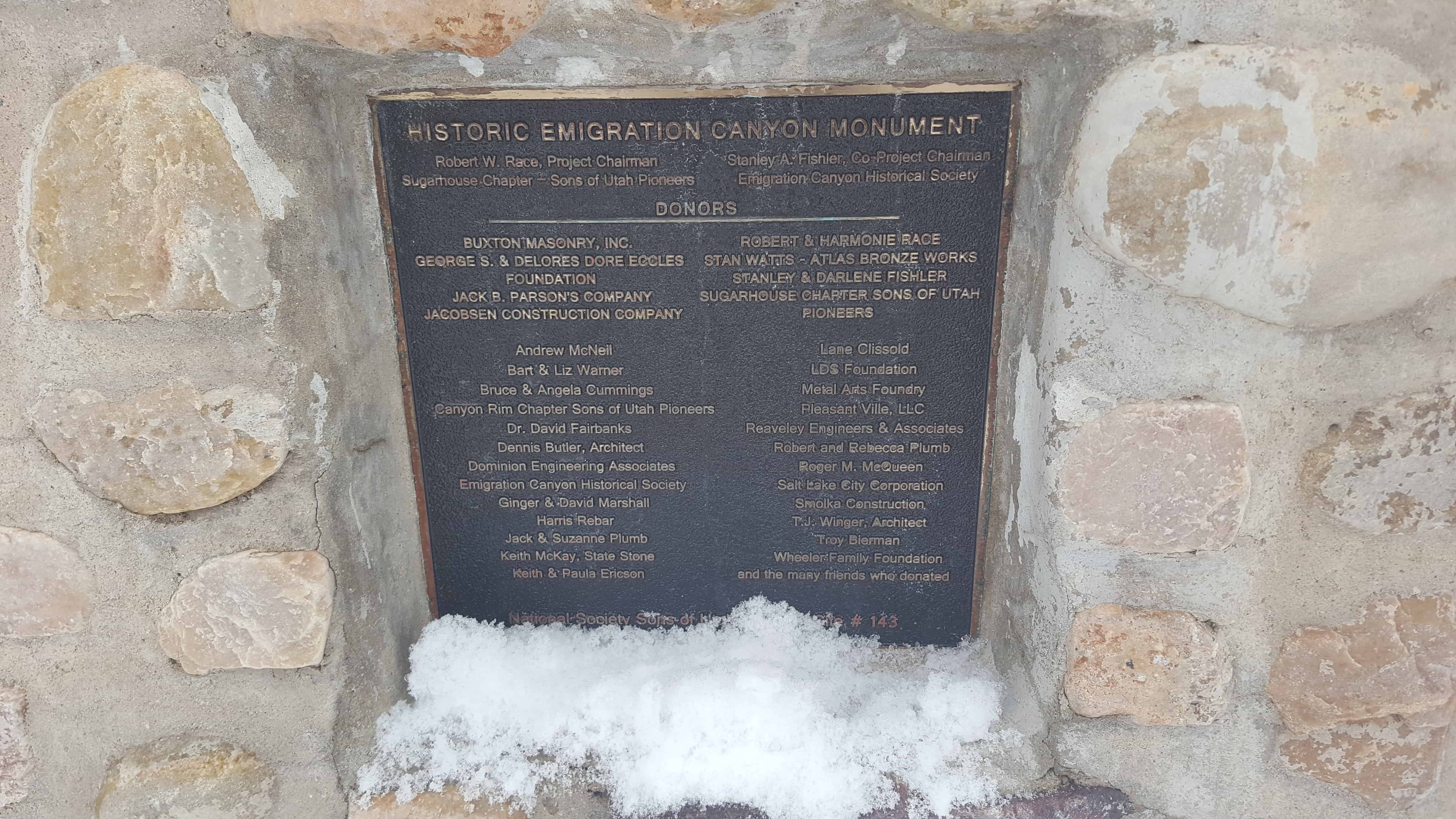
HISTORIC EMIGRATION CANYON MONUMENT Robert W. Race, Project Chairman Stanley A Fishler, Co-Project Chairman Sugarhouse Chapter – Sons of Utah Pioneers
Emigration Canyon Historical Society A list of donors are displayed on the plaque.