• About JacobBarlow.com
  • Cemeteries in Utah
  • D.U.P. Markers
  • Doors
  • Exploring Utah Email List
  • Geocaching
  • Historic Marker Map
  • Links
  • Movie/TV Show Filming Locations
  • Oldest in Utah
  • Other Travels
  • Photos Then and Now
  • S.U.P. Markers
  • U.P.T.L.A. Markers
  • Utah Cities and Places.
  • Utah Homes for Sale
  • Utah Treasure Hunt

JacobBarlow.com

~ Exploring with Jacob Barlow

JacobBarlow.com

Tag Archives: utah

Handcart Pioneer Monument

05 Tuesday Aug 2014

Posted by Jacob Barlow in Uncategorized

≈ Leave a comment

Tags

Art, historic, Salt Lake City, Salt Lake County, Temple Square, utah

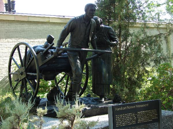
The Handcart Pioneer monument is a tribute to the thousands of hardy Mormon pioneers who, because they could not afford the larger ox-drawn wagons, walked across the rugged plains in the 1850’s, pulling and pushing all of their possessions in handmade, all-wood handcarts. Some 250 died on the journey, but nearly 3,000, mostly British converts, completed the 1,350-mile trek from Iowa City, Iowa, to Salt Lake Valley. Many latter-day saints today proudly recount the trials and the triumphs of their ancestors who were among the Mormon handcart pioneers.

Sculpted by Torleif S. Knaphus. Located at Temple Square in Salt Lake City, Utah

Kanab Forts

05 Tuesday Aug 2014

Posted by Jacob Barlow in Uncategorized

≈ 1 Comment

Tags

historic, Kanab, Kane County, utah

2017-03-05 10.14.09

Kanab gets its name from an anglicized form of the Piute word “willows”, which grew abundantly along the creek banks.

The Kanab Fort was begun in 1864, under the direction of Jacob Hamblin as a protection from the Indians and as a base to explore the region. Severe and frequent Indian attacks made it impractical to maintain the fort and it was abandoned in 1866. It was reoccupied in 1870 by Levi Stewart and others sent to do missionary work and to establish peace with the Indians. In December of that same year there was a fire in the fort that killed Levi’s wife and five sons. There is a historical plaque in Kanab marking the site of the fort honoring Jacob Hamblin and Levi Stewart.

The Fort you can see in the distance, west of this sign, is a movie prop. In the 1930’s the Parry brothers realized the potential of the movie industry in this area. The town was soon nicknamed “Little Hollywood” because so many movies were made in this area. This fort was built for the movie “Buffalo Bill”. The fort was intended to remain as a landmark and a set for other movies, but for the filming of “Fury at Furnace Creek”, it was soaked with gasoline and burned to the ground. It was rebuilt and burned again for “The Apple Dumpling Gang”.
7abfb0e6-4713-4e0d-b9f3-6349161d061b

2017-03-05 10.14.13
Deputy Brian B. Harris

Half Way House

05 Tuesday Aug 2014

Posted by Jacob Barlow in Uncategorized

≈ 1 Comment

Tags

historic, Salt Lake County, Sandy, SUP, utah

picture07oct07-248

Only a few yards from this monument – to the Northwest – stood the Milo Andrus “Halfway House”, a comfortable and convenient two-story pioneer inn. The inn was one of several built along State Street in the 1850-80 period to care for the many south and northbound travelers. The Andrus Inn became known as the “Halfway House” because it was located midway between “Traveler’s Rest” at 6400 South State and Porter Rockwell‘s layout near the Point of the Mountain. If one were walking, riding horseback or in a buggy or ther (sic) horse-drawn conveyance, the Andrus place was always a welcome stop. Built in 1859 and the early part of the 1860’s, the Halfway House served as both a hotel and a family residence for 120 years. The structure was moved from here beginning in 1982 to the Pioneer Trails State Park in Salt Lake City after its history was authenticated by the State. The inn was actually a project of Lucy Loomis Tuttle Andrus, one of several wives of Milo. Lucy was a widow with children when Milo married her in 1850 as they were crossing the plains. At the time he was leader of some Church members who were enroute to Utah from England. After the group arrived in Utah, he worked hard to get them all situated. During the 1850’s Milo and his families were involved in the great Church colonization program. Locations they helped settle were Green River, Dixie and Cache Valley in Utah, and Oxford and the Salmon River Country in Idaho. They eventually bought 160 acres in the Dry Creek area of the Jordon Bottoms that included this land on State Street. This area is now part of the community of Crescent.

See other historic markers in the series on this page for SUP Markers.

picture07oct07-246

Neff’s Station

05 Tuesday Aug 2014

Posted by Jacob Barlow in Uncategorized

≈ 1 Comment

Tags

historic, Salt Lake County, Sandy, SUP, utah

picture07oct07-248

The adjoining Benjamin Barr Neff farm – one forth (sic) of a mile north of here – became known as “Neff’s Station at Dry Creek” or just “Neff’s Station” after Deseret Telegraph established an office here in 1871. Mary Ellen Love Neff, 20-year-old second wife of Benjamin operated the station. The Neff farm was an ideal location for the telegraph station because the north-south line connecting Salt Lake City and east-west lines connecting Alta and Bingham, crossed at that point. With the coming of the cross-valley railroad through the Sandy area in 1873, the telegraph station was moved to that community. Mary Ellen was retained as operator for the new Sandy station. Benjamin Barr Neff, of Swiss ancestry, became a successful farmer owning dairy cows, horses and mules. The well which he dug for the farm was used until a few years ago and remains on the property.

See other historic markers in the series on this page for SUP Markers.

picture07oct07-247

Caroline Carr Armstrong House

05 Tuesday Aug 2014

Posted by Jacob Barlow in Uncategorized

≈ 3 Comments

Tags

Capitol Historic District, historic, Historic Homes, NRHP, Salt Lake City, Salt Lake County, utah

2018-04-09 19.27.26

This Victorian style house was probably built c. 1889 for Caroline Carr Armstrong, a widow who, with her six children, had come to Utah from Australia the previous year. Caroline was born in Kent, England, in 1840, but at a young age she immigrated to Australia where she joined the LDS Church in 1871. Her husband, William, apparently died just prior to her coming to Utah. Mrs. Armstrong passed away in this house in 1903.

2018-04-09 19.27.58

2018-04-09 19.27.54

2018-04-09 19.27.40

2018-04-09 19.27.38

picture24nov07-208
picture24nov07-209

Location: N 40° 47.084 W 111° 53.816

Caffrey & Davis Furniture Company / Senior Hotel

05 Tuesday Aug 2014

Posted by Jacob Barlow in Uncategorized

≈ 1 Comment

Tags

historic, NRHP, Springville, utah, utah county

This Building was constructed in 1890 as the retail furniture store of James Caffrey and Samuel Davis, partners in the firm Caffrey & Davis ( “Furniture, Carpets, and Wallpaper”), operating here until 1907, when it was purchased by Walter and Herbert Robinson. They, together with their brothers, formed the Robinson Brothers Music Co., which sold furniture and “musical merchandise.” In 1921, the building was purchased by Laura Senior. The Senior family added the rear addition with the second story and operated a confectionary, cafe, hotel, and billiard hall.

Through most of the 1930s, the Senior Hotel was one of three hotels operating in Springville. Following Laura’s death, title passed in 1931 to her son, Oliver, who lived here with his second wife, Priscilla, and his children, Max and Jaqueline. Max, Oliver’s son by his first marriage, worked as hotel clerk and later manager. The hotel and associated tourist court ( behind this building ) continued to be a family owned and operated venture through the 1960s, closing in the 1980s, after which the building sat vacant. In May 1995 Bradley and Elizabeth Petersen purchased the building and began an extensive restoration project to preserve and return it to use.

Located at 296 South Main Street in Springville, Utah

Related:

  • Navajo Water Carrier (sculpture located here)
picture10dec07-008
ingress_20130810_142059_12

Butch Cassidy Childhood Home

22 Tuesday Jul 2014

Posted by Jacob Barlow in Uncategorized

≈ 2 Comments

Tags

Circleville, Garfield County, Historic Homes, utah

picture24jul07-166

I’ve always been a huge fan of Robert LeRoy Parker (Butch Cassidy.)

I’ve heard over the years that this was his childhood home, but I’ve heard that about a couple of places. Either way it’s fun to dream and they’ve transformed this from just a cabin in a field to a place with signs and a parking lot and officially calling it his boyhood home.

Location, N 38.14477 W 112.30479 (just south of Circleville, Utah)

Text below from a a sign on site:

Butch Cassidy Childhood Home

Robert LeRoy Parker, A.K.A. Butch Cassidy, lived here with his family from 1880 to around 1884.

He was 14 when his family moved here and about 18 when he left. Research about Parker’s life here is ongoing. Information uncovered so far shows he was a fun big brother, loved dancing and racing horses, liked to read, was a hard worker and was kind to animals.

picture24jul07-165

Update: 2019 – I stopped by again, they’ve really upgraded the place.  They put in a bathroom, a parking lot with fencing around it, some old farm equipment and plaques and signs about Butch Cassidy.   They’ve also closed up the cabin so you can’t just go in whenever you want like I could when I took the above photos.   

Update 2020:

They’ve upgrade even more, it’s come a long way from the cabin in the field I stopped by in 2007.

Castle Gate Historic Marker Highway Pull-Off

14 Monday Jul 2014

Posted by Jacob Barlow in Uncategorized

≈ 1 Comment

Tags

historic, Mining, Railroad, Soldier Summit, spanish fork canyon, utah

Driving highway 6/50 between Price/Helper and Spanish Fork, in Price Canyon not too far from Helper, Utah you can see an area to pull off the highway with a lot of history to read.

So far there are six markers/monuments:

  • Carbon Plant Memorial
  • Carbon Power Plant
  • Castle Gate Mine Disaster
  • Robbery of the Pleasant Valley Coal Company
  • Utah’s Coal Industry
  • Willow Creek Mine Explosion

Carbon Plant
Carbon Plant


2014-06-18 14.35.39


2014-06-18 14.35.51

2014-06-18 14.36.03


2014-06-18 14.36.19

Pleasant Valley Junction

14 Monday Jul 2014

Posted by Jacob Barlow in Uncategorized

≈ 1 Comment

Tags

historic, Soldier Summit, spanish fork canyon, utah

  • Picture I took in 2007
    Picture I took in 2007

Pleasant Valley Junction about 1/2 mile south of this site, began in the early 1880’s when the Rio Grande Railroad extended the main line from Tucker over the summit into Carbon County. A round house was built and a branch line extended to the Pleasant Valley Coal camps. All coal shipped from Pleasant Valley used this new route. The area, renamed Colton in the late 1890’s, was important as a railhead for livestock shipment, general freight and a thriving ice industry. Another part of Colton’s economy was the mining and milling of ozokente, a mineral wax found only here and in Austria. The store behind this monument was moved from the original townsite in 1936. Dedicated July 13, 1991.

  • Picture I took in 2007
    Picture I took in 2007
  • Picture I took in 2014
    Picture I took in 2014

Soldier Summit Historic Marker

14 Monday Jul 2014

Posted by Jacob Barlow in Uncategorized

≈ 1 Comment

Tags

historic, Soldier Summit, spanish fork canyon, utah

On September 11, 1776. Two Franciscan Priests, Father Escalante & Father Dominguez entered what is now the State of Utah, and several weeks later camped in a mountain pass.
It is believed that the fathers gave the pass its first name, calling it Grassy Pass. The name was changed to Soldier Pass when Johnson’s Army at Camp Floyd was ordered east in 1861, about 40 officers & enlisted men from the Southern States were given permission to leave the U.S. Army & go south to join the Confederate Army. They arrived at Grassy Pass in a blizzard, six or seven men & a fourteen year old boy were frozen to death & were buried by a spring near the summit of the pass. The Rio Grande Western Railroad Company in 1880 named the pass Soldier Summit in its first time table.

  • Picture taken in 2009
    Picture taken in 2009
  • Picture taken in 2009
    Picture taken in 2009
  • Picture taken in 2014
    Picture taken in 2014
  • Picture taken in 2014
    Picture taken in 2014
← Older posts
Newer posts →

Follow Jacob

Follow Jacob

Blog Stats

  • 2,033,157 hits

Social and Other Links

BarlowLinks.com

Recent Posts

  • Dixie Sorghum (Molasses) Mill
  • This is the Place State Park
  • Eyes Westward
  • Wellsville Relief Society Meetinghouse
  • Angels Are Near Us

Archives


Loading Comments...