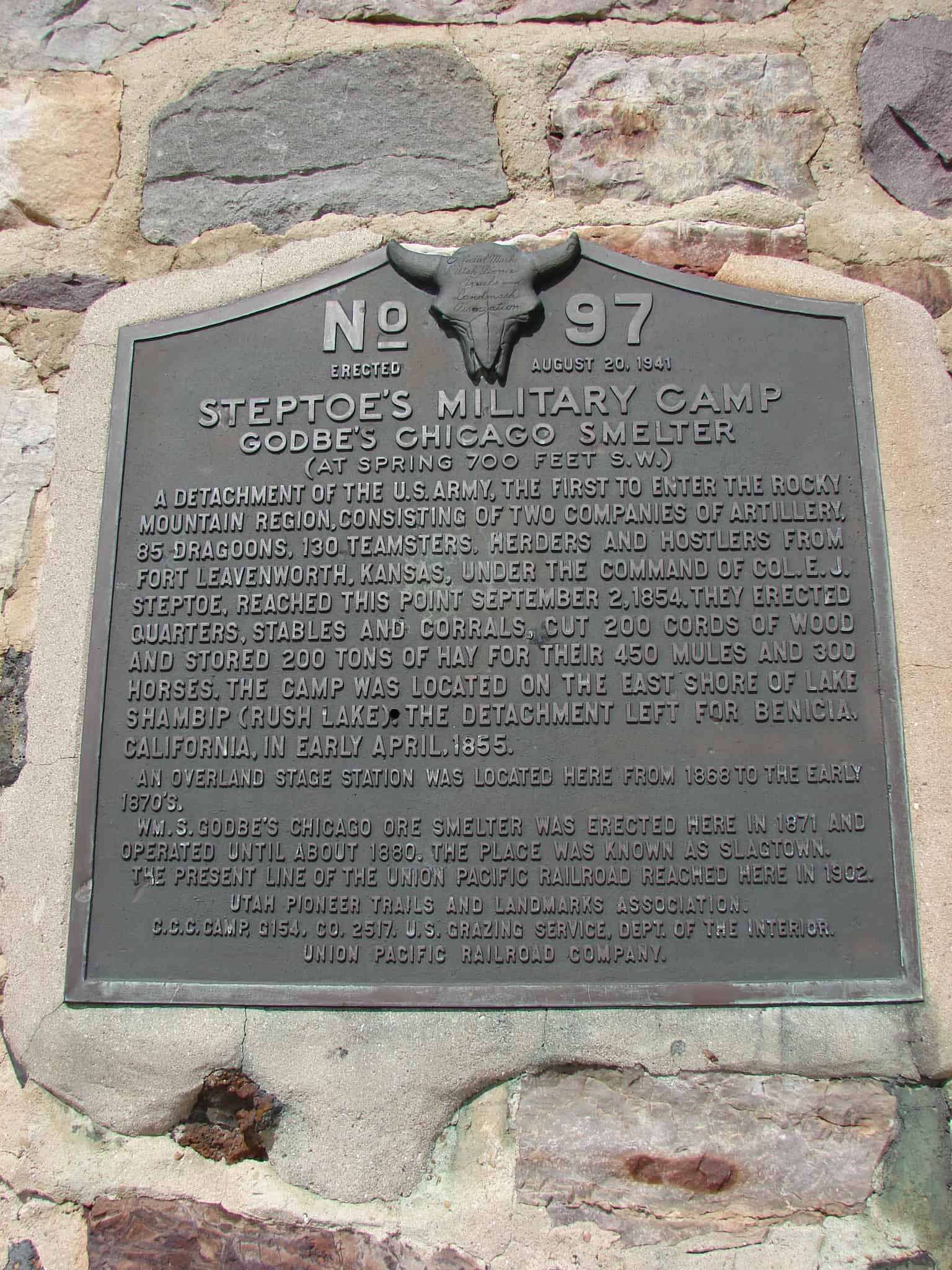
A detachment of the U.S. Army, the first to enter the Rocky Mountain Region, consisting of two companies of artillery, 85 dragoons, 130 teamsters, herders and hostlers from Fort Leavenworth, Kansas, under command of Col. E.J. Steptoe, reached this point September 2, 1854. They erected quarters, stables and corrals, cut 200 cords of wood and stored 200 tons of hay for their 450 mules and 300 horses. The camp was located on the east shore of Lake Shambip (Rush Lake). The detachment left for Benecia, California, in early April, 1855. An Overland Stage Station was located here from 1868 to the early 1870’s. Wm. S. Godbe’s Chicago Ore smelter was erected here in 1871 and operated until about 1880. The town was known as Slagtown. The present line of the Union Pacific Railroad reached here in 1902.
The text above is from this historic marker which is #97 of the UPTLA Markers and was later adopted to be an SUP Marker. It is located just south of Stockton, Utah
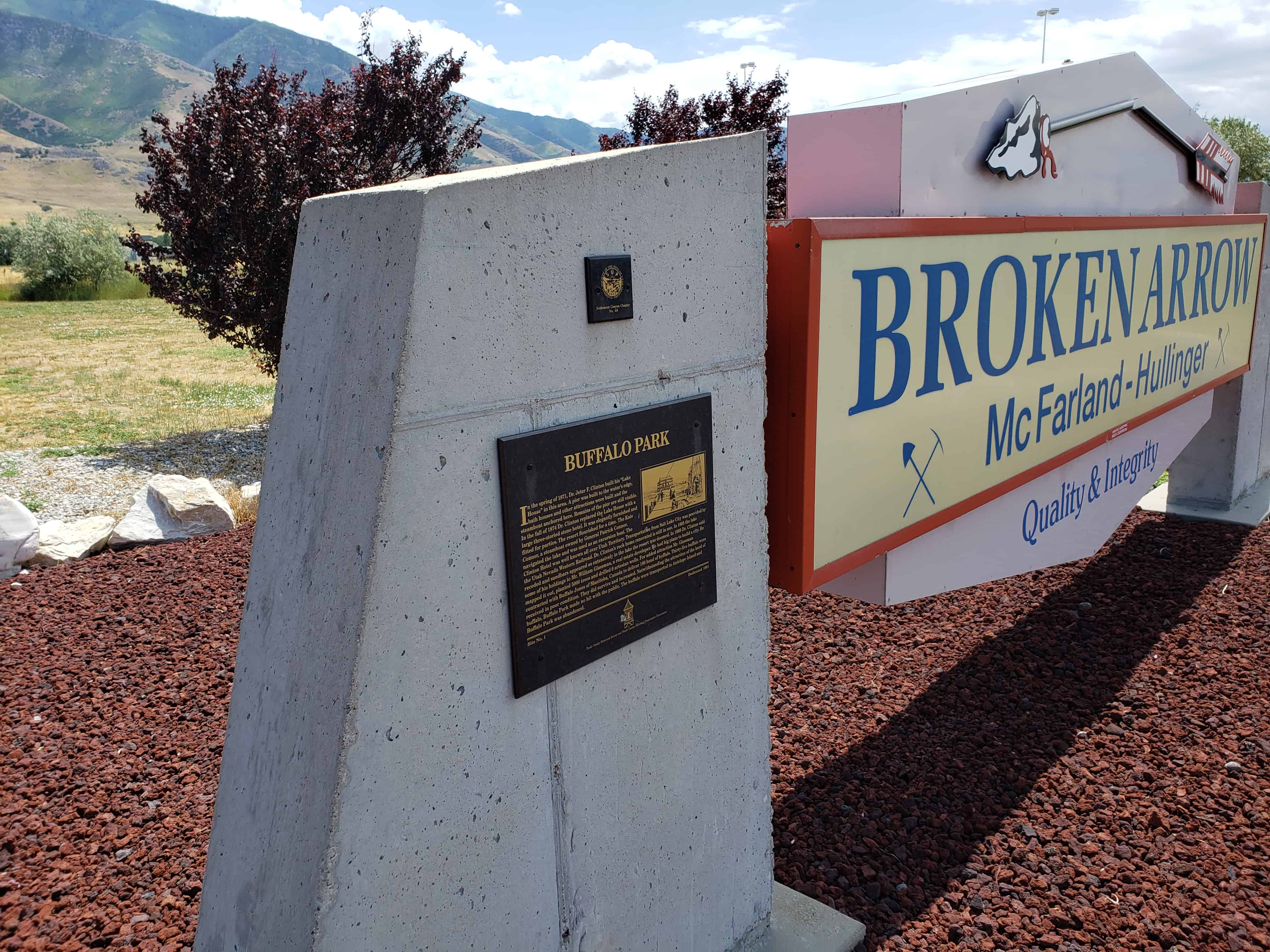
In the Spring of 1871 Dr. Jeter F. Clinton built his “Lake House” in this area. A pier was built to the water’s edge, bath houses and other attractions were built and the steamboat anchored here. Remains of the pier are still visible.
In the fall of 1874 Dr. Clinton replaced the Lake House with a large three-storied stone hotel. It was elegantly furnished and fitted for parties. The resort flourished for a time. The Kate Connor, a steamboat owned by General Patrick Connor, navigated the lake and was used as an excursion boat.
The Clinton Hotel was well known all over Utah Territory. Transportation from Salt Lake City was provided by the Utah Nevada Western Railroad. Dr. Clinton’s rock home renovated is still in use. In 1885 the lake receded and sandbars appeared so extensively in the lake the resort was doomed. In 1889 Dr. Clinton sold some of his holdings to Mr. William Glassman, a real estate developer. He had big plans to build a city. He mapped it out, planted 5,000 trees and drilled 6 artesian wells.
For added attraction Mr. Glassman contracted with Buffalo Jones of Manitoba, Canada to deliver 100 head of buffalo. Thirty-five buffalo were received in poor condition. They did survive and increase. Notwithstanding the attraction of the herd of buffalo, Buffalo Park made no hit with the public, the buffalo were transported to Antelope Island and Buffalo Park was abandoned.
There is a historic marker not far from here that was placed on a boulder taken from the Old Buffalo Ranch.
See other historic markers in the series on this page for SUP Markers.
Around 1891 after the D & R G W railroad replaced the narrow gauge, with standard gauge track. The division point was consolidated in Helper. At this time a 15 stall roundhouse, a new depot and other accommodations were built. In 1919 the division point was relocated to Soldier Summit. The roundhouse was moved piece by piece to the new location. In 1929, adverse weather conditions at 7,700 feet forced the railroad to move operations back to Helper.
The roundhouse was again dismantled and moved back to its original location. The roundhouse operated until the steam locomotive was phased out and replaced with diesel electric power in the 1950’s.
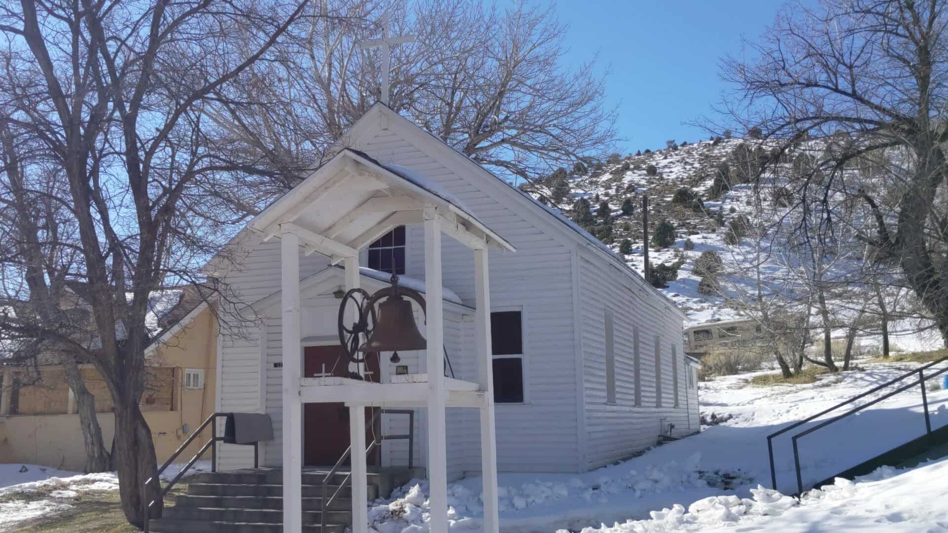
St. Patrick’s Catholic Church, built 1885, remains as one of the oldest Catholic Churches in Utah. Constructed under the direction of Reverend Denis Keily, the building represents both the importance of Irish settlement in Tintic as well as the early Catholic missionary efforts of Bishop Lawrence Scanlan. The church was listed in the National Register of Historic Places on March 14, 1979 as part of the Eureka Historic District.
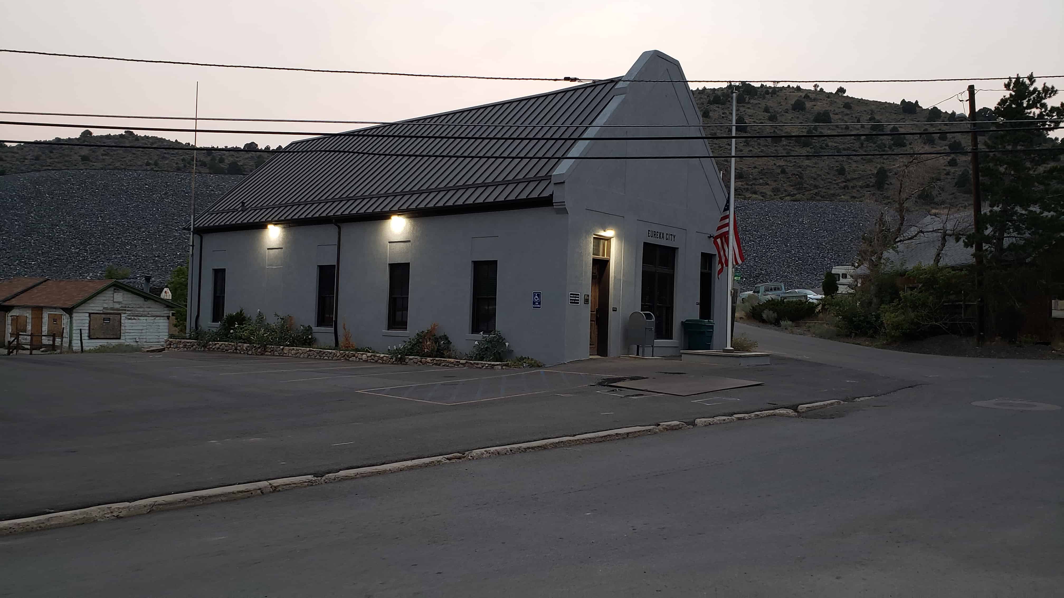
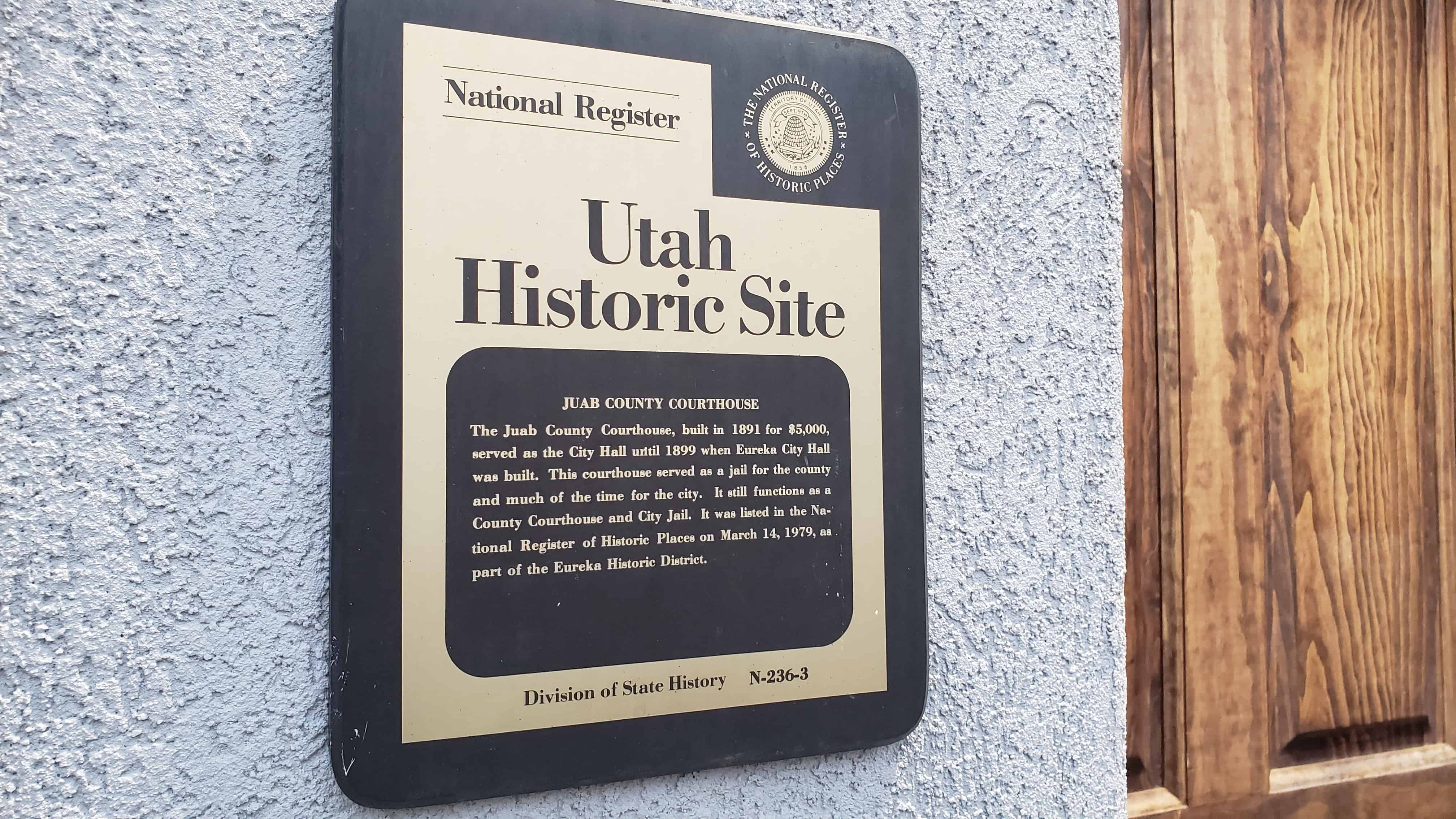
The Juab County Courthouse, built in 1891 for $5,000 served as the City Hall until 1899 when Eureka City Hall was built. This courthouse served as a jail for the county and much of the time for the city. It still functions as a County Courthouse and City Jail. It was listed in the National Register of Historic Places on March 14, 1979, as part of the Eureka Historic District.
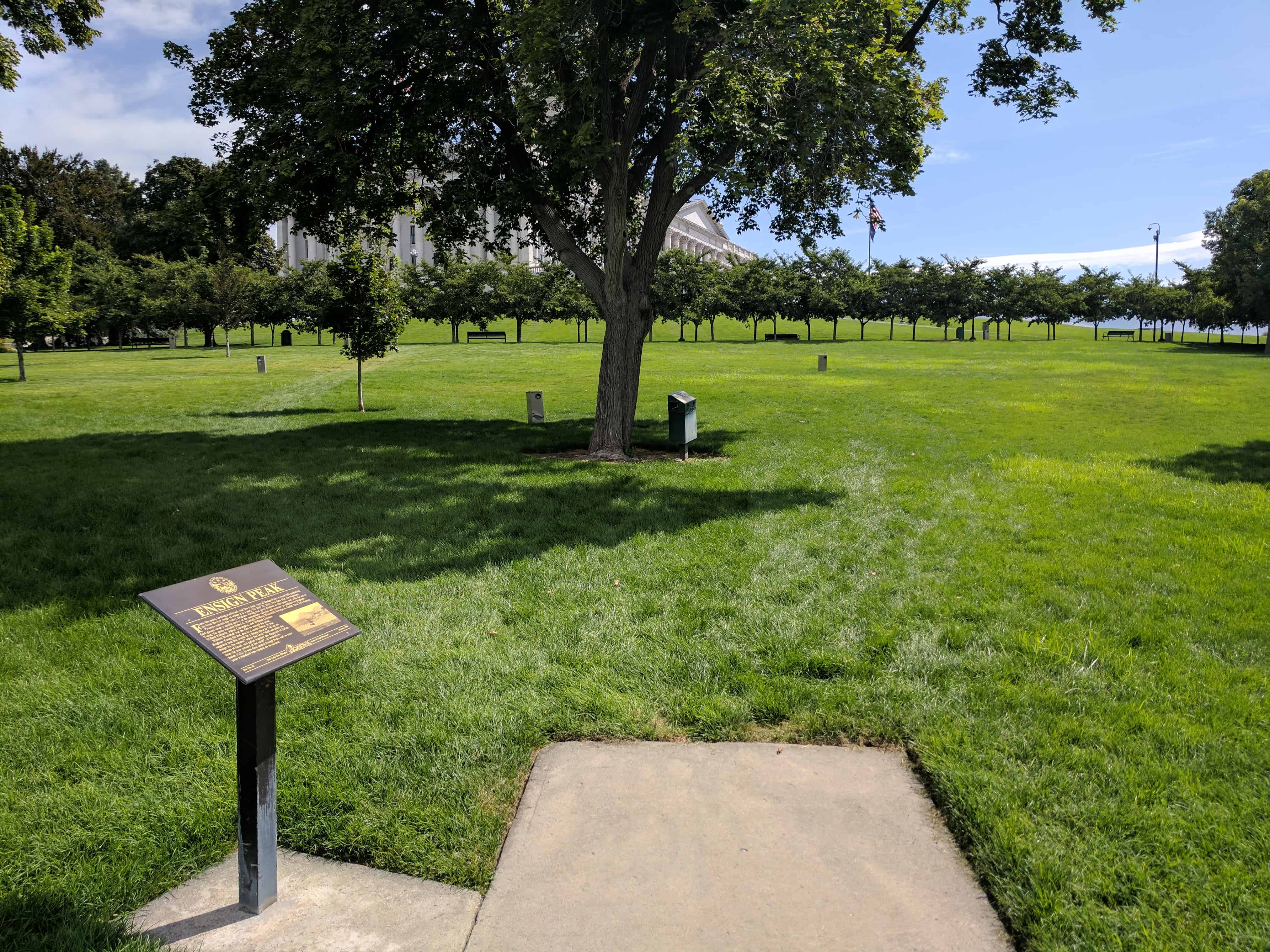
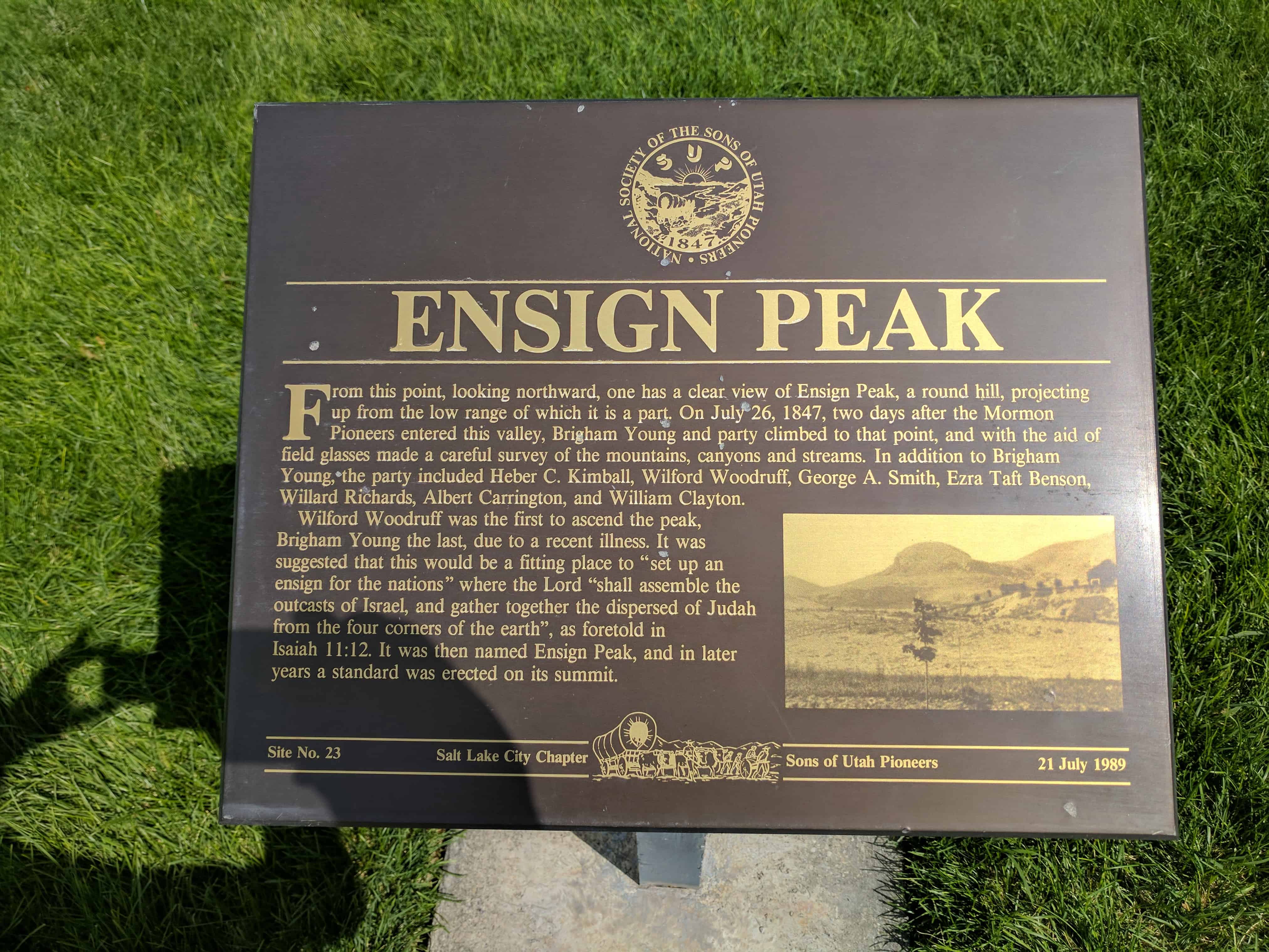
Elevation 5,441 ft. Monday morning, July 26, 1847, the pioneers resumed their secular labors. Although Brigham Young, leader of the pioneer band, was suffering from mountain fever, he directed that exploration work be started immediately, one party being headed by himself. The party left about 10 o’clock a.m.. This party consisted of Brigham Young, Heber C. Kimball, Willard Richards, Wilford Woodruff, George A. Smith, Ezra T. Benson, Albert Carrington and William Clayton. Messrs. Kimball, Woodruff, Benson and Smith had ascended City Creek Canyon several miles the Saturday evening before. The party now climbed to the hills west of the canyon and proceeded northward, the President still riding. “A good place to raise an ensign,” he remarked…as the party planted their feet upon a prominent peak near the western edge of the mountainous spur projecting in the valley from the northeast. Ensign Peak, the mountain, was accordingly named, which title it still bears…from the top of the peak the view was more than ever sublime. The “Ensign” in the minds of the Mormon Pioneers concerned not one nation, but all nations; not one epic or age, but all epics and all ages; not nationality but humanity, is its scope and concern. It was the sign and ensign of the Empire of the Christ; it was a prophecy of the time to come when the kingdoms of this world would become “the kingdom of our Lord and of his Christ; and he shall reign for ever and ever.” East Millcreek Chapter, dedicated April 21, 1986
See other historic markers in the series on this page for SUP Markers.
The first known residents of the Riverton area were the Yo No Indians, a poor tribe living along the Jordan River. Well-worn trails extended from Utah Lake where various tribes wintered, to Bear Lake where they rendezvoused during the summer. Much credit is due for the free use of their byways, exchange of leather goods and furs, relinquishing land, and their general friendly attitude. Four forts erected west of the river were never seriously needed for protection. They were: Wight’s Fort, north by the Oquirrh Mountains; English Fort at the Bennion Cemetery site; Fort Herriman, 5 miles west of here; and Cedar Fort to the south.
Riverton was born of the Pioneer Spirit that moved men and women independently to reach out and wrestle a living from the harsh, untamed land. Many settlers spent their first year in dug-outs along the Jordan River as did the Yo No’s.
In 1855, Abraham Hunsaker, a convert from Illinois and a member of the Mormon Battalion, moved his herds across the river to join Jesse Beckstead and Samuel and Thomas Butterfield who were already using the land for grazing. Abraham was the first man to own land and divert water. But Archibald Gardner was the first to live here and become the largest land owner; so for many years the area was called “Gardnersville.” Judge Charles Smith later named the town “Riverton”.
From 1850 to 1881 most attempts to bring water to the land were inadequate, however, some succeeded. The fertile soil responded, and the permanent expanding settlement was here to stay. Sheep, cattle, alfalfa, beets, minerals, poultry, and dry farming all had their “hey day” and contributed greatly to the growing economy.
A maturity milestone was reached August 8, 1886, when the Riverton Ward of the Church of Jesus Christ of Latter-day Saints was organized with 138 members. Orrin P. Miller served as the first Bishop. Plans were soon underway for a new meeting house. Richard W. Kletting was selected as architect. (He was also architect of the Utah State Capitol and the old Saltair Pavillion). Willard C. Burgon was named building contractor. With visions of new hope, the people geared for Riverton’s “Grandest Effort.” Construction began in 1899.
This magnificently beautiful domed church, with the inscription “HOLINESS TO THE LORD” over the front door was erected at 12800 South Redwood Road on a two-acre site donated by Thomas P. Page. With its high dome, it was an inspiring edifice and could be seen for long distances.
On January 21, 1900, Bishop Miller was sustained stake president, Gordon S. Bills was ordained bishop of the 346 member ward. The lower part of the building was in use by 1908. There were many financial hardships during construction, however, it was finally paid for and dedicated on December 20, 1920. The cost was approximately $25,000.00 plus much donated labor and materials. Because of its high ceilings, excessive maintenance and heating problems, it was razed in 1940 after just 30 years of use. Gone, too, are the brick kiln, Tithing Yard, molasses mill, flour mill, harness shop, the Commercial Building and dance hall built by Daniel Densley, and the Salt Lake and Utah Railroad (Orem Commuter Line) 1914-1945.
Many fond memories linger in the hearts of the long-time residents, the “Pioneers” of Riverton. This monument is gratefully erected to their memory and integrity.
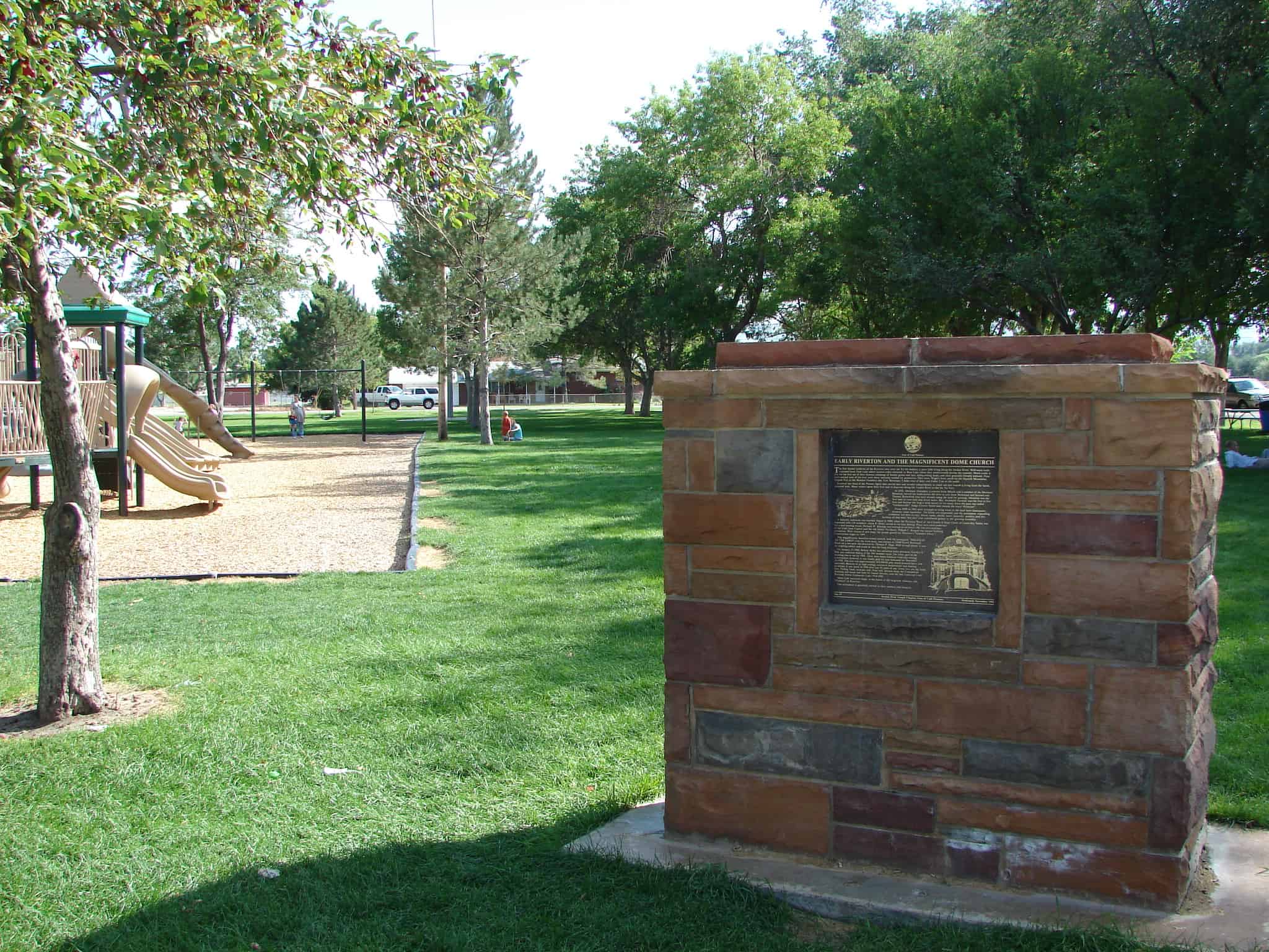
Sons of Utah Pioneers historic marker #7 was located here at Riverton City Park (1452 W 12600 S in Riverton) – this is the original monument before it was later split into two separate monuments, “Early Riverton” and “The Magnificent Dome Church,” both still located here at the park.
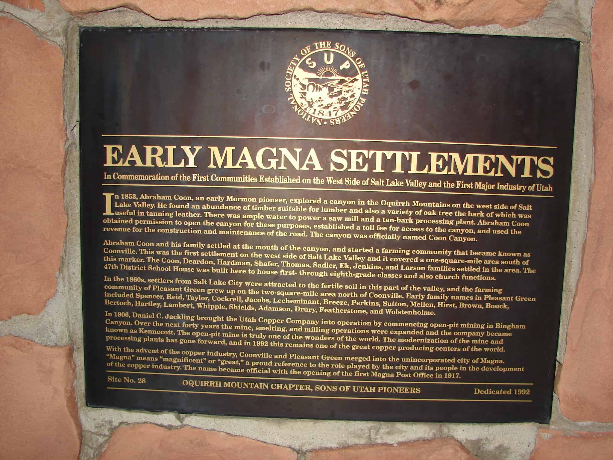
EARLY MAGNA SETTLEMENTS In Commemoration of the First Communities Established on the West Side of Salt Lake Valley and the First Major Industry of Utah In 1853 Abraham Coon, an early Mormon pioneer, explored a canyon in the Oquirrh Mountains on the west side of Salt Lake Valley. He found an abundance of timber suitable for lumber and also a variety of oak tree the bark of which was useful in tanning leather. There was ample water to power a saw mill and a tan-bark processing plant. Abraham Coon obtained permission to open the canyon for these purposes, established a toll fee for access to the canyon, and used the revenue for the construction and maintainance of the road. The canyon was officially named Coon Canyon. Abraham Coon and his family settled at the mouth of the canyon, and started a farming community that became known as Coonville. This was the first settlement on the west side of Salt Lake Valley and it covered a one-square-mile area south of this marker. The Coon, Deardon, Hardman, Shafer, Thomas, Sadler, Ek, Jenkins, and Larson families settled in the area. The 47th District School House was built here to house first- through eighth-grade classes and also church functions. In the 1860s, settlers from Salt Lake City were attracted to the fertile soil in this part of the valley, and the farming community of Pleasant Green grew up on the two-square-mile area north of Coonville. Early family names in Pleasant Green included Spencer, Reid, Taylor, Cockrell, Jacobs, Lecheminant, Breeze, Perkins, Sutton, Mellen, Hirst, Brown, Bouck, Bertoch, Hartley, Lambert, Whipple, Shields, Adamson, Drury, Featherstone, and Wolstenholme. In 1906, Daniel C. Jackling brought the Utah Copper Company into operation by commencing open-pit mining in Bingham Canyon. Over the next forty years the mine, smelting, and milling operations were expanded and the company became known as Kennecott. The open-pit mine is truly one of the wonders of the world. The modernization of the mine and processing plants has gone forward, and in 1992 this remains one of the great copper producing centers of the world. With the advent of the copper industry, Coonville and Pleasant Green merged into the unincorporated city of Magna. “”Magna” means “magnificent” or “great,” a proud reference to the role played by the city and its people in the development of the copper industry. The name became official with the opening of the first Magna Post Office in 1917.
See other historic markers in the series on this page for SUP Markers.
George Quinn McNeil was born to John McNeil and Mary Jan Quinn McNeil on January 4, 1865, in Bountiful, Utah. He married Adriane Marie Thomas on August 15, 1888. They lived on the family farm located on the southeast side of Bountiful City. Today, the area is known as North Canyon.
McNeil assisted Daniel Davis at the grist mill located on this site. NcNeil captured bears in the mountains above Bountiful City which were trained to do work around the mill. The bears were also taught to pull McNeil’s wagon. He desired to take the bears on a tour from Bountiful City throughout the United States and have them perform a circus-type act. McNeil had traveled only a short distance from Brigham City with the bears when they misbehaved and the tour was cancelled.
George Quinn McNeil died on June 23, 1943.
We are pleased to recognise his unique role regarding the mill. (Caption under Photograph) George McNiel (sic), and Jerry Ellis, second from left, caught and trained bears at the Heber C. Kimball Grist Mills.
See other historic markers in the series on this page for SUP Markers.
Pioneer Founder of Woods Cross, Utah Born Oct. 16, 1800 in Dutchess County, New York. Died Apr. 15, 1892 Baptized into the Church of Jesus Christ of Latter-Day Saints Feb. 20, 1833, Ernestown, Canada by Brigham Young. Persecuted with Saints in states of Ohio, Missouri and Illinois. Guard, Nauvoo Temple. Exchanged 260 acres for 2 wagons, 4 oxen, 3 cows and 1 carriage. In recognition of talent as an exceptional farmer, Brigham Young requested he remain on the Missouri to plant crops for migrating saints. At age 48 he captained 50 wagons in 2nd Co., 1st Div. of Brigham Young’s Co. Leaving in spring of 1848 and arriving in Salt Lake Valley Sept. 20, 1848. Later settled near this plot after finding richest soil. In 1850 he built a two story adobe house which for years was the only religious meeting place in Davis County. Later, he built the first public hall complete with belfry and bell which rang for all affairs. Hall housed the first formal local church organizations. The choir consisted of his own family. Wood School held here, the teacher being paid by hall owner and contributions. This hall provided a lovely recreational area. He was known for his sense of humor, devotion to Church, civic mindedness, help to many settlers getting started, care for foster homeless children and Indians. With the crossing of the railroad through Wood homestead, area was named Woods Cross by Brigham Young. General area south to Salt Lake City, west to Great Salt Lake and east to Sessions Settlement (Now Bountiful) came to be known as Woods Cross. Local area still bears name. This private cemetery plot dedicated Aug. 27, 1858 by Daniel Wood This Memorial erected by Daniel Wood Posterity and dedicated by his Great Grandson Henry D. Moyle, First Counselor in the First Presidency of the Church of Jesus Christ of Latter-day Saints, Apr. 1, 1962. (Other side of monument) Interred in Wood Cemetery…(list of names)…


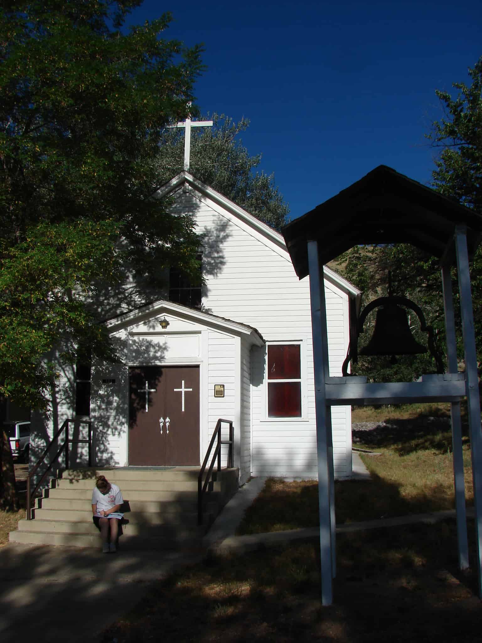 St. Patrick’s Catholic Church, built 1885, remains as one of the oldest Catholic Churches in Utah. Constructed under the direction of Reverend Denis Keily, the building represents both the importance of Irish settlement in Tintic as well as the early Catholic missionary efforts of Bishop Lawrence Scanlan. The church was listed in the National Register of Historic Places on March 14, 1979 as part of the Eureka Historic District.