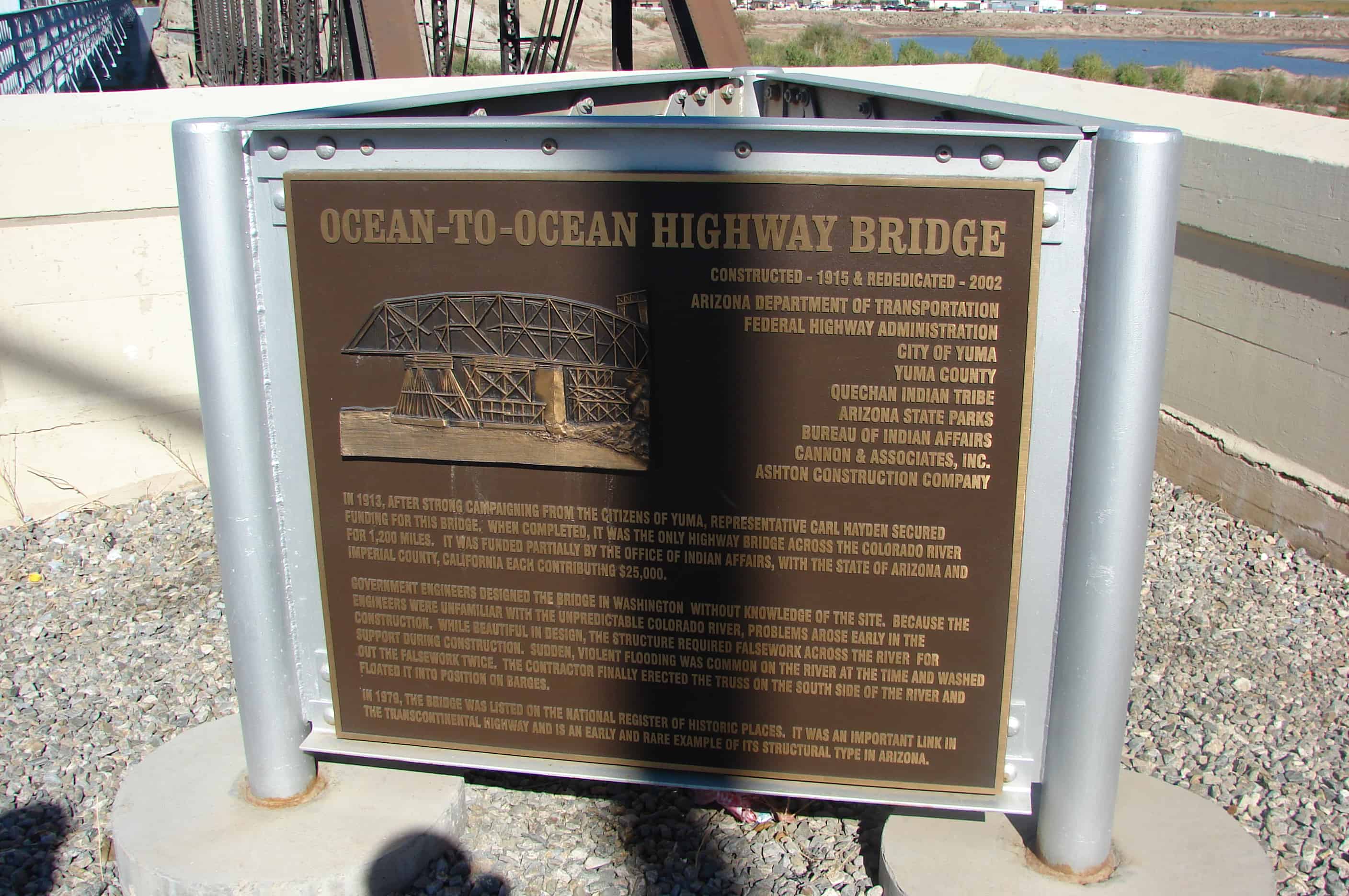
The bridge was constructed in 1915 through a joint effort between the Office of Indian Affairs and the states of California, Arizona and New Mexico to promote traffic along the Ocean-to-Ocean Highway. The bridge was the only one over the Colorado for 1,200 miles. The bridge has no center pillar because of the Colorado River potential roughness.
During the 1930s, California California erected a checkpoint on their side to prevent jobless Oakies and Arkies from entering.
The bridge stopped operations in 1988. In 2002 it reopened to one way traffic only. The Ocean-to-Ocean Highway Yuma” sign was restored and is illuminated at night.
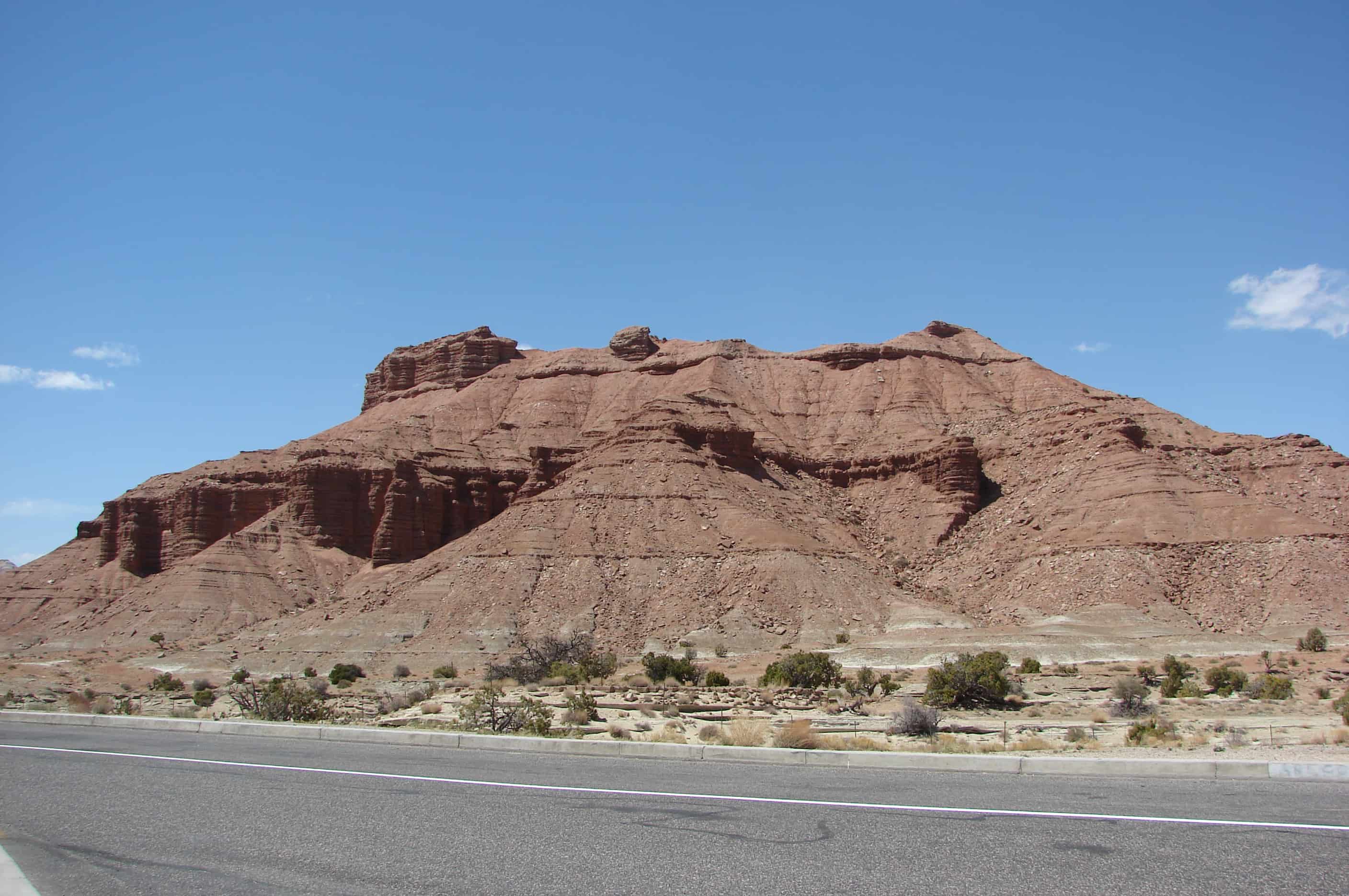
The San Rafael Swell is a kaleidoscope of colors splashed across a rugged landscape of cliffs, canyons, arches and pinnacles. Erosion sculpts the stone, but the environment in which it was deposited determines its color. In general, the brighter colors, red, yellow, and orange, are present in rocks deposited where oxygen was present. Examples of these environments are sand dunes and floodplain material higher then the water table. The duller colors, gray, light green, and purple, are present in rocks where there was no oxygen as they were deposited. These would be formed at the bottom of an inland sea or below a water table. These boggy places also trapped the bodies of dinosaurs ad preserved their bones as fossils. The Cleavland-Lloyd Dinosaur Quarry to the north of here has yielded hundreds of dinosaur fossils. This world famous quarry has produced more dinosaur mounts for display in museums then any other in the world, all thanks to the amazing fosilization of these once boggy areas now in front of you and all around you, take a minute to look at how different this place once was.
Photograph: “Portion of road up Parley’s Canyon, showing how unfinished it was, but adequate to get wagons and horses over.” Photograph: “Early form of transportation up Parley’s Canyon. Notice narrow path behind wagon.” Parley P. Pratt’s toll road. The “Deseret News” dated June 29, 1850, described Parley Pratt’s new route through Parley’s Canyon as the Golden Pass, the new route through the mountains. This alternate valley entrance was explored and built by Parly P. Pratt and was used as a means of securing fuel and timber for himself and other emigrants. To defray his expenses for the road building, he initiated a toll for others to use his road in 1848. His established rates were as follows: 75c for a two-horse outfit, 10c for each additional pack or saddle animal, and 1c per head for sheep and loose stock. His toll house was located near the creek and approximately 1/2 mile west of Suicide Rock. Initially the Golden Pass Road was passible for horse and wagon, and between 1850-1869 thousands of Mormon pioneer emigrants, California-bound gold seeks, Pony Express riders, overland stage coaches, plus thousands of soldiers traveled over this dirt road.
Built on a 200 acre farmland north of Parley’s Creek and east of 20th East between the years of 1849-1852, it was the largest grist mill in the Utah Territory. It operated between 1852-1857 and was shut down in 1857 due to the entrance of Johnson’s U.S. Army. The mill was operated by means of a large water wheel located on the northeast corner of the mill. Water in turn was conveyed by a mill race from Parley’s Creek (just east of Suicide Rock) approximately one mile to the spillway and onto a twelve foot diameter water wheel. The shaft of this waterwheel conveyed take-off power for belt drive to the Industrial Center’s machinery. Following in 1857 start-up, the milling equipment was removed in 1863 and the plant was changed over to a cotton mill and then a woolen mill until its demise by fire.
The house was built in 1916 by Joe Burgess. He hauled lava rock from the nearby black hill for the foundation stones and constructed the home out of formed cement blocks made by Lim Canfield. These formed cement blocks became popular in the early part of the 20th century when the stone masons, who had brought their trade from the old country, started becoming extinct. The forms were made so the blocks had the exterior texture of handcut sandstone blocks.
Constructed by Israel Ivins, the community’s first medical doctor. This home had, at the rear, a little shop which served as a drugstore that provided medicine and remedies for the embryonic town.
Pioneer Home of Erastus Goddard and Josephine Nixon Whitehead
Build in the 1880’s by George Whitehead for his brother Erastus “Ras” Whitehead. The foundation is lava rock. The walls are adobe brick, hand made from straw, clay and horsehair. Beams and wood structures are nailed with handmade square head nails. Erastus and his father owned the A.R. Whitehead and Son Mercantile Store on Tabernacle Street which was a very successful business. He and Josephine had seven children, who were raised in this home. Erastus died in 1906, at the age of 34.
The famous camel herd with which the name of Hi Jolly is linked constitutes an interesting sidelight of Arizona history….
Jefferson Davis (afterward President of the Southern Confederacy). As Secretary of War. Approved a plan to experiment with camels for freighting and communication in the arid Southwest….Major Henry C. Wayne of the U.S. Army and Lt. D.D. Porter (later a distinguished admiral in the Civil War) visited the Levant with the storeship “Supply” and procurred 33 camels which were landed at Indianola, Texas. February 10, 1856. 41 were added on a second voyage….
With the first camels came. As caretaker, Haiji Ali whose Arabic name was promptly changed to “Hi Jolly” by the soldiers. And by this name he became universally known. His Greek (?) name was Philip Tedro….On the Beale Expedition in 1857 to open a wagon road across Arizona from Fort Defiance to California. The camels under Hi Jolly’s charge. Proved their worth. Nevertheless, the War Department abandoned the experiment and the camels were left on the Arizona desert to shift for themselves. Chiefly roaming this particular section. They survived for many years creating interest and excitement …. Officially the camel experiment was a failure. But both Lt. Beale and Major Wayne were enthusiastic in praise of the animals. A fair trail might have resulted in a complete success.
Last Camp of Hi Jolly Born somewhere in Syria about 1828 Died at Quartzsite December 16, 1902 Came to this country February 10, 1856 Camel Driver – Packer Scout – Over Thirty Years a faithful aid to the US Government
This two-story, one-part commercial block building was constructed in 1889. The second story brick addition dates from c. 1890. Both were built during Sandy’s first major period of development known as the “Mining, Smelting, and Small Farm Era, 1871-c1910”. The “Sandy Co-op” sign panel was located below the corbelled brick cornice was alternating rows of dog tooth coursing. The relatively simple design and bilateral symmetry of the building is expressive of the aesthetics employed on commercial structures in Sandy. It is important as the only two-story commercial block building remaining from the City’s original commercial district.
The Sandy Co-op Mercantile and Manufacturing Co. occupied the building until 1908 when it changed hands several times before being purchased and used by the Knights of Pythias between 1912-1943. The main floor was reportedly used for the sale of general merchandise and the upper floor as a meeting and dance hall. The building was converted to serve as Sandy City’s fire station between 1949-1984. In 1988, it was restored to house the Sandy City Museum.
The text on this page is from the plaques on the building. The building is located at 8744 South Center Street in the historic sandy area of Sandy, Utah
The land was originally owned by La Grande Young and sold to Wells Clark in 1886. Sandy Co-op purchased it in 1888. The building was constructed in 1890 with a co-op merchantile store on the bottom floor and a social hall on the top floor. Dances and other social events were held weekly as the main social gatherings. The bottom level was used by a variety of occupants including Jenkins Funeral Parlor from 1908 until 1912. During this time period a huge advertisement for “Bull Durham” was painted on the outside south wall. Located across the street was a Utah Southern Railroad Station. The old building survived the vibration of a great many trains during Sandy’s coming of age. In 1912, Mingo Lodge No. 6 Knights of Pythias purchased the building to be used as a lodge hall and rental for other social functions. It was referred to as the “K.P. Lodge” during this time period. In 1939 Sandy City purchased the building as an interim fire station until a new facility was built in 1984 at another location. The building’s architecture dates from 1890 and is of a non-reinforced masonry construction “low fired brick on a quartzite-granite foundation”.
.
ZCMI Co-op Building 1890-1908 Official outlet of ZCMI (Zion’s Co-operative Mercantile Institution), “America’s First Department Store”. This building housed the “Sandy Co-op” which was part of the ZCMI co-operative system servicing more than 150 communities in the intermountain area with retail commodities and services beginning in 1868.
This property was one owned by Jacob Gates, the 2nd mayor if St. George. Whether he constructed the Victorian house during his ownership (1876-1890) or it was built a little later, about 1893, by Hector & Ella McQuarrie is not certain.
What is known is that Ella rented some of the rooms to “drummers” (salesmen) travelling to St. George on business. Four of her six children were born here.


 .
.


