• About JacobBarlow.com
  • Cemeteries in Utah
  • D.U.P. Markers
  • Doors
  • Exploring Utah Email List
  • Geocaching
  • Historic Marker Map
  • Links
  • Movie/TV Show Filming Locations
  • Oldest in Utah
  • Other Travels
  • Photos Then and Now
  • S.U.P. Markers
  • U.P.T.L.A. Markers
  • Utah Cities and Places.
  • Utah Homes for Sale
  • Utah Treasure Hunt

JacobBarlow.com

~ Exploring with Jacob Barlow

JacobBarlow.com

Tag Archives: DUP

Ferron Pioneers

15 Friday Aug 2014

Posted by Jacob Barlow in Uncategorized

≈ Leave a comment

Tags

Castle Valley, DUP, Emery County, Ferron, historic, utah

The first permanent settlers of Ferron arrived December 6, 1877. They were Swen Larsen and son, Niels Christian Larsen; Nicholas Larsen and wife Helena, Peter F. Peterson and wife, Caroline. The first woman with a family of children, Ann Singleton Wrigley, wife of Joseph Wrigley, came in the fall of 1878. Ferron was named in honor of A.D. Ferron, a pioneer surveyor of Cache Valley.

Located at 40 West 100 North in Ferron, Utah

  • DUP # 117
    DUP # 117
  • 20140810_190431
  • 20140810_190441

Old Social Hall

14 Thursday Aug 2014

Posted by Jacob Barlow in Uncategorized

≈ 1 Comment

Tags

Castle Dale, Castle Valley, DUP, Emery County, historic, Orangeville, utah

DUP # 217

DUP # 217

20140810_172845 20140810_172848

In 1888 the men and boys of this community brought material from the mountains and built a hall on this spot of ground. They formed a company and rented the hall. The L.D.S. Church purchased the building when Jasper N. Robertson was first bishop. It was used for church, school, and recreation sixty-three years. The hall was razed in 1952. The bell was procured by Charles Oliphant in 1889 and hung in the belfry where it tolled for fires, time, funerals, and all special occasions.

First Public Building in Orangeville

14 Thursday Aug 2014

Posted by Jacob Barlow in Uncategorized

≈ 1 Comment

Tags

Castle Dale, Castle Valley, DUP, Emery County, historic, Orangeville, utah

  • DUP # 111
    DUP # 111
  • 20140810_173654
  • 20140810_173658

On this site in December, 1880, a primitive meeting house was built, a log building which served the community for church, school, dramatic and recreational purposes. Orangeville had been a part of Castle Dale, but in 1882, it was organized as a Ward and named Orangeville for Orange Seeley, a prominent colonizer of Castle Valley. The first bishop was Jasper Robertson; first school teacher and musical director, Samuel R. Jewkes; first dramatic and social leader John. H. Reid.

Old Ranger Station

13 Wednesday Aug 2014

Posted by Jacob Barlow in Uncategorized

≈ 1 Comment

Tags

DUP, Emery County, historic, Historic Buildings, Huntington, utah

OLD RANGER STATION

This building, erected in 1909 at Bear Creek site, was originally the first Ranger Station in Huntington Canyon. John P. Brockbank served as ranger from November, 1909, until November, 1917. Later it was used as summer headquarters by the forest ranger in the nearby district. Finally it was given to the Daughters of Utah Pioneers, and in 1951, it was moved to this location to be headquarters of the Huntington Camp.

20140810_143730 20140810_143733 20140810_143737 20140810_143739 20140810_143745 20140810_143747 20140810_143756 20140810_143816

Huntington’s First Meeting House

13 Wednesday Aug 2014

Posted by Jacob Barlow in Uncategorized

≈ 1 Comment

Tags

Castle Valley, DUP, Emery County, Huntington, utah

HUNTINGTON‘S FIRST MEETING HOUSE

January, 1879, Orange Seeley, presiding valley bishop, appointed Elias Cox to preside over the Latter-day Saints who had settled on Huntington Creek. In October a ward was organized. Logs were hauled from the canyon and a meeting house erected by Benjamin Jones, Sr., John F. Wakefield, W. Albert Guymon, Sr., Walsh Caldwell, William Avery, Milas E. and Joseph R. Johnson, Albey W. Sherman, Jr., David Cheney, John Wimmer and others. The building was 40 x 60 feet, split shingle roof, lumber floor and benches of split logs. It was dedicated December 1880, and served the community for church, school, and recreation. The building was destroyed by fire in 1918.

20140810_143316 20140810_143336 20140810_143347

Huntington

13 Wednesday Aug 2014

Posted by Jacob Barlow in Uncategorized

≈ 1 Comment

Tags

Castle Valley, DUP, Emery County, historic, Huntington, utah

  • 20140810_141945
  • 20140810_141949
  • 20140810_141956
  • 20140810_142003

HUNTINGTON

In 1875, Leander Lemmon and James McHadden, seeking a good range for their horses found feed plentiful at the mouth of Huntington Canyon and vicinity. Mr. Lemmon brought sheep and cattle from Cottonwood, Salt Lake County. In the autumn of 1876, he built the first log cabin on Huntington Creek near this marker. An irrigation ditch was dug, taking water from the nearby creek. The town is situated on Huntington Creek, from which it receives its name.

Old Palmyra

02 Wednesday Jul 2014

Posted by Jacob Barlow in Uncategorized

≈ 2 Comments

Tags

DUP, Forts, historic, Palmyra, spanish fork, SUP, utah, utah county

picture7sep07-065

This Monument marks the South-West corner of Fort Palmyra. This Fort was built by the settlers for protection. Palmyra was selected in 1852 as a suitable place to build a city by Apostle Geo. A. Smith. The first home was built in August of that year. W.W. Willis was its first Mayor. The first bishop was Stephen Markam. Silas Hillman was the first school teacher. Upon advice from President Brigham Young, the settlers of Palmyra moved to Spanish Fork, in 1856.

This marker was placed in 1933 and the D.U.P. didn’t start numbering their historic markers until 1934 so it is not in the numbered list.

Related Posts:

  • Fort Palmyra Pioneer Settlement
  • Palmyra, Utah
Picture 018
Picture 019
Picture 020

Pioneer Heritage Cemetery – Spanish Fork

01 Tuesday Jul 2014

Posted by Jacob Barlow in Uncategorized

≈ 2 Comments

Tags

Cemeteries, DUP, historic, spanish fork, utah, utah county

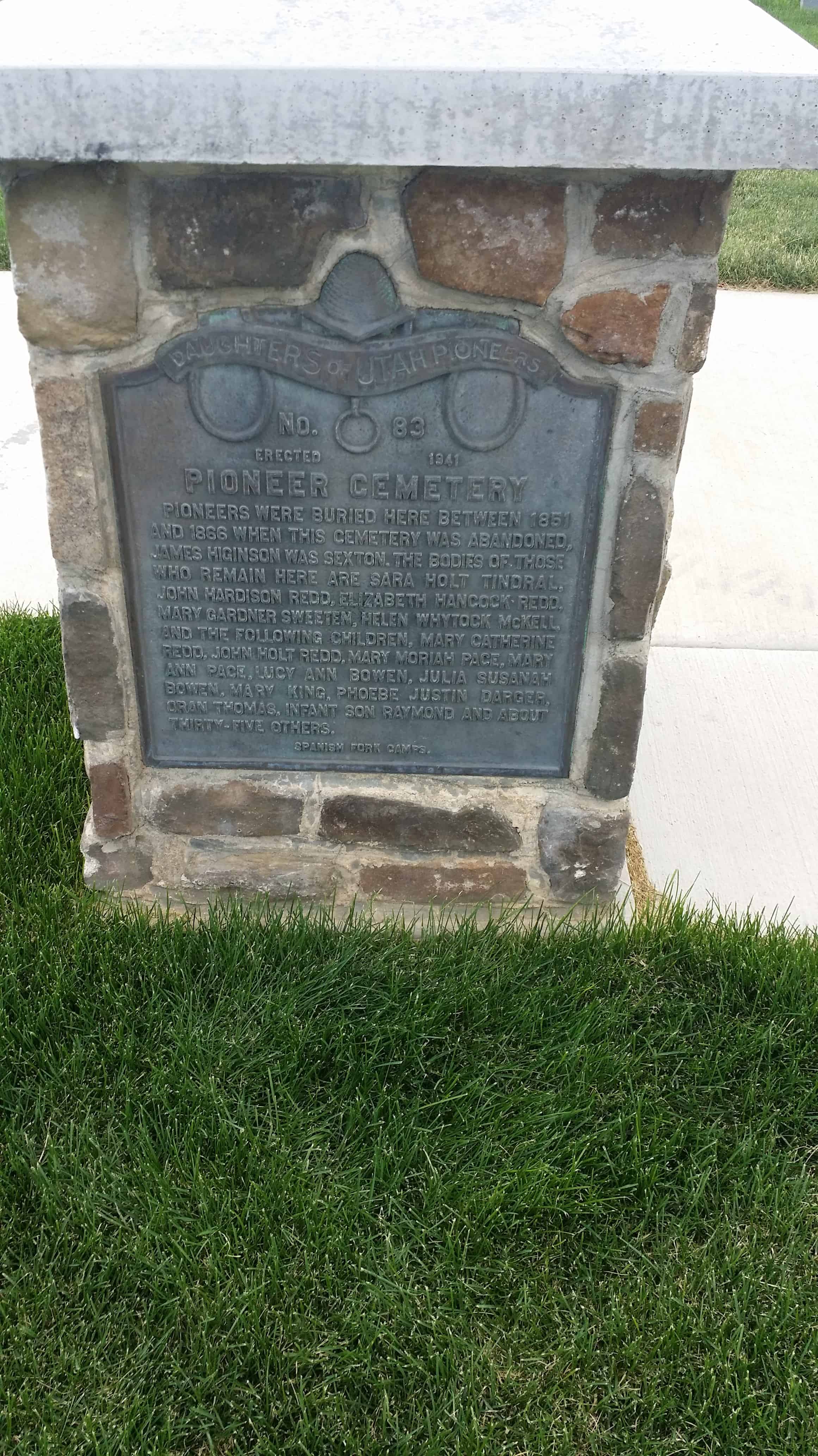
Back in 2006/2007 I was searching out the historic markers placed by the Daughters of Utah Pioneers, #83 (see information here) was at the Pioneer Heritage Cemetery in Spanish Fork, Utah.

Here are a few photos I took back then:

ImageImageImage

As you can see there wasn’t much to look at, a monument and an arch and a weed-filled field. 

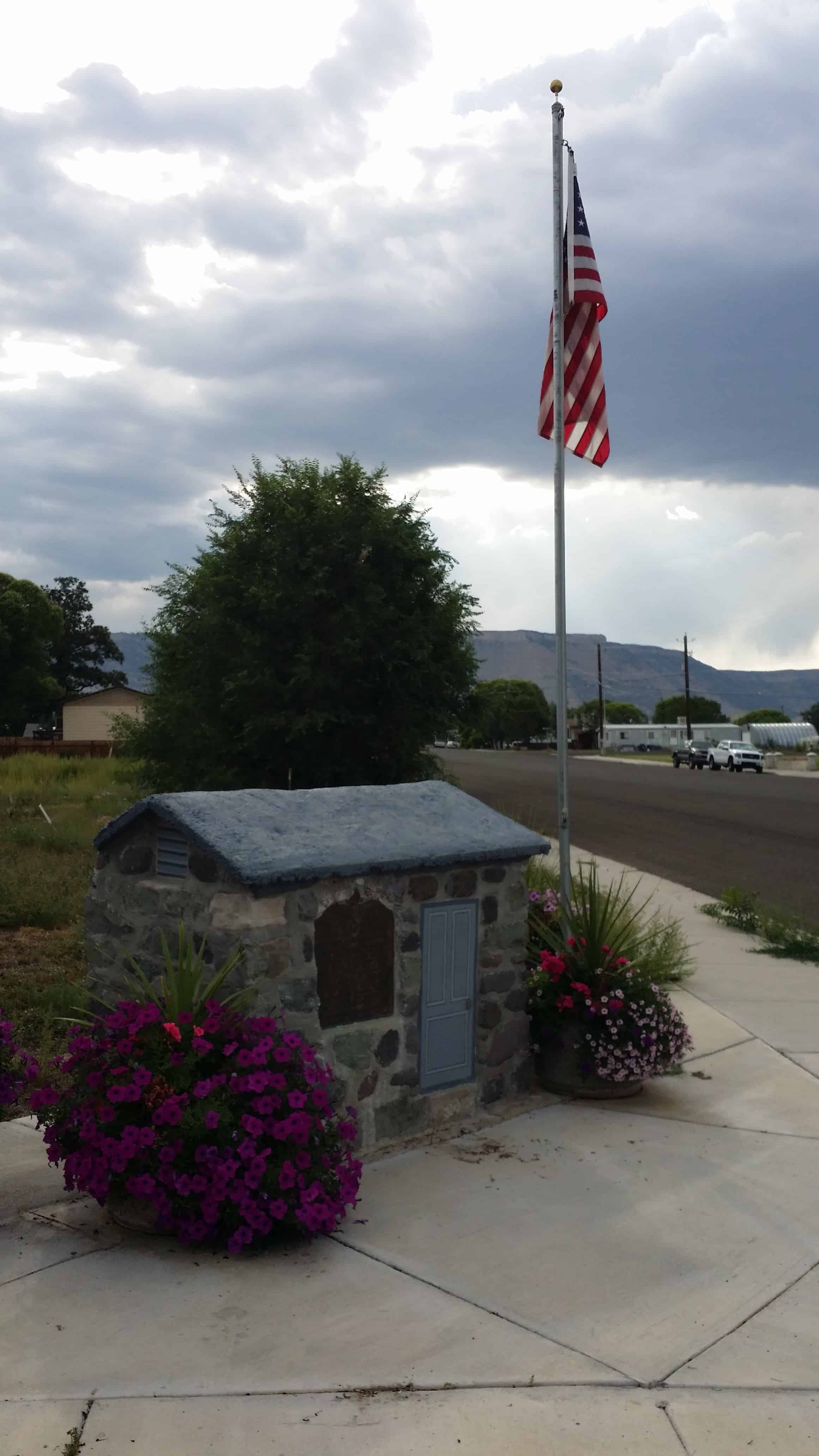
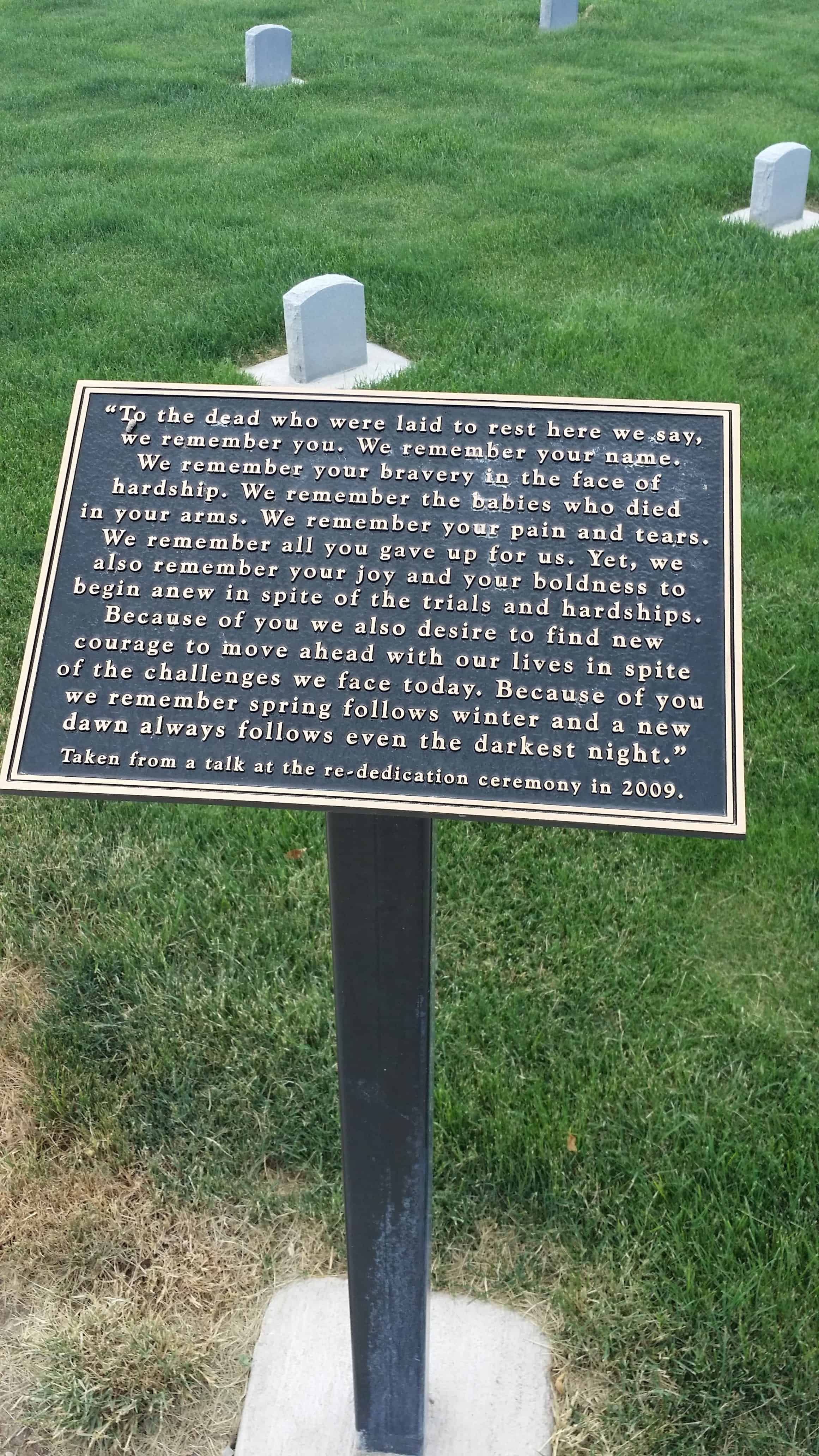
Well they have since really made it quite nice, plaques with stories, a nice lawn, headstones in rows.   It’s a great place.   Here are some more photos that I took the other day when I stopped by with the family.

Image

Settlers to this area built some of their first homes directly below this pioneer cemetery. During warn weather they loved in tents or four foot wide wagon boxes. Many settlers dug into the ground or hillside for shelter during the winter. There were once so many dugouts built in the area that Spanish Fork was known as “Gopher Town.”

One family who came to this area was quite astonished to see the women coming out of the “holes,” along the hillside like gophers. During a very wet spring, one of the dugouts started to leak. More dirt was placed on the top of the roof. This extra weight caused the support beam of the family’s root to break killing the father. He is buried here not far from his home.

Image
Image

Early settlers often faced multiple deaths and burials in one family. On May 5th, 1851, John and Elizabeth Hancock Redd’s 17 year old daughter, Mary Catherine Redd, suddenly because ill and died within hours. She was buried on this bluff overlooking the River Bottoms. John and Elizabeth suffered another loss as their 15 year old son, John Holt Redd, was thrown from his horse on November 15, 1853. His heartsick mother died three days later. Then on June 15, 1858 John Hardison Redd died after being kicked by a horse. All four family members were buried in the Redd Cemetery, now known as the Heritage Pioneer Cemetery.

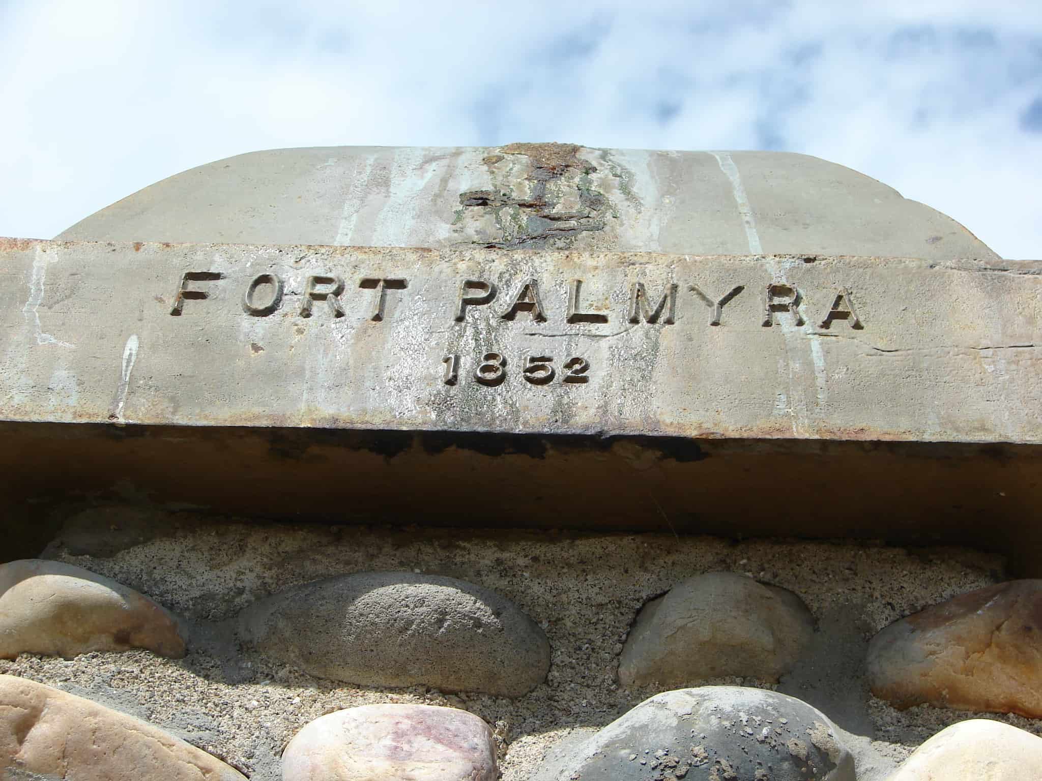
This Cemetery has also been called The Old Palmyra Graveyard, the East Bench Graveyard, and The Upper Cemetery.

Image
Image

In the spring of 1854, Mary Ann Boice took a Native American child, Alpharetta, into her home. Alpharetta was brought to her by the child’s father after his wife died in childbirth. She took care of the infant, along with her own infant son Alfred. Alpharetta soon died of measles and was buried here. Later, Mary Ann and her husband John were called to settle Kamas. While traveling to their new home, their wagon was surrounded by a band of angry Native Americans covered with war paint. A brave, Alpharetta’s father, recognized Mary Ann, got down from his horse and convinced the cheif to let them go in peace.

Image
Image
Image

Helen Whytock McKell was born in Scotland. She married there, and her husband died leaving her with a son to raise. She then married Robert McKell and together with her son emigrated to Utah.

Brigham Young called Robert and Helen to enter into the practice of polygamy. Within days of the polygamist marriage, Helen became ill and died. Robert McKell’s journal said that she was “buried in the old cemetery on the brow of the bench land near the Vincent farm in the River Bottoms.”
When Robert died later, the family brought Helen’s broken headstone to the new cemetery and placed it beside Robert’s.

Image

Early settlers in Spanish Fork took care of their family burials with the aid of friends and volunteers. The winters were severe and often the ground was frozen hard. Those assisting with burials had to clear snow and sagebrush, mark off the grave, then make and tend a fire that would burn all night to soften the ground.
The first burial in the Pioneer Cemetery was Mary Catherine Redd in 1851. Some of the people buried here were later moved to the Spanish Fork City Cemetery. In 1866 a sexton was appointed to start keeping records of burials which were already being made in the City Cemetery.

ImageImageImageImageImageImage

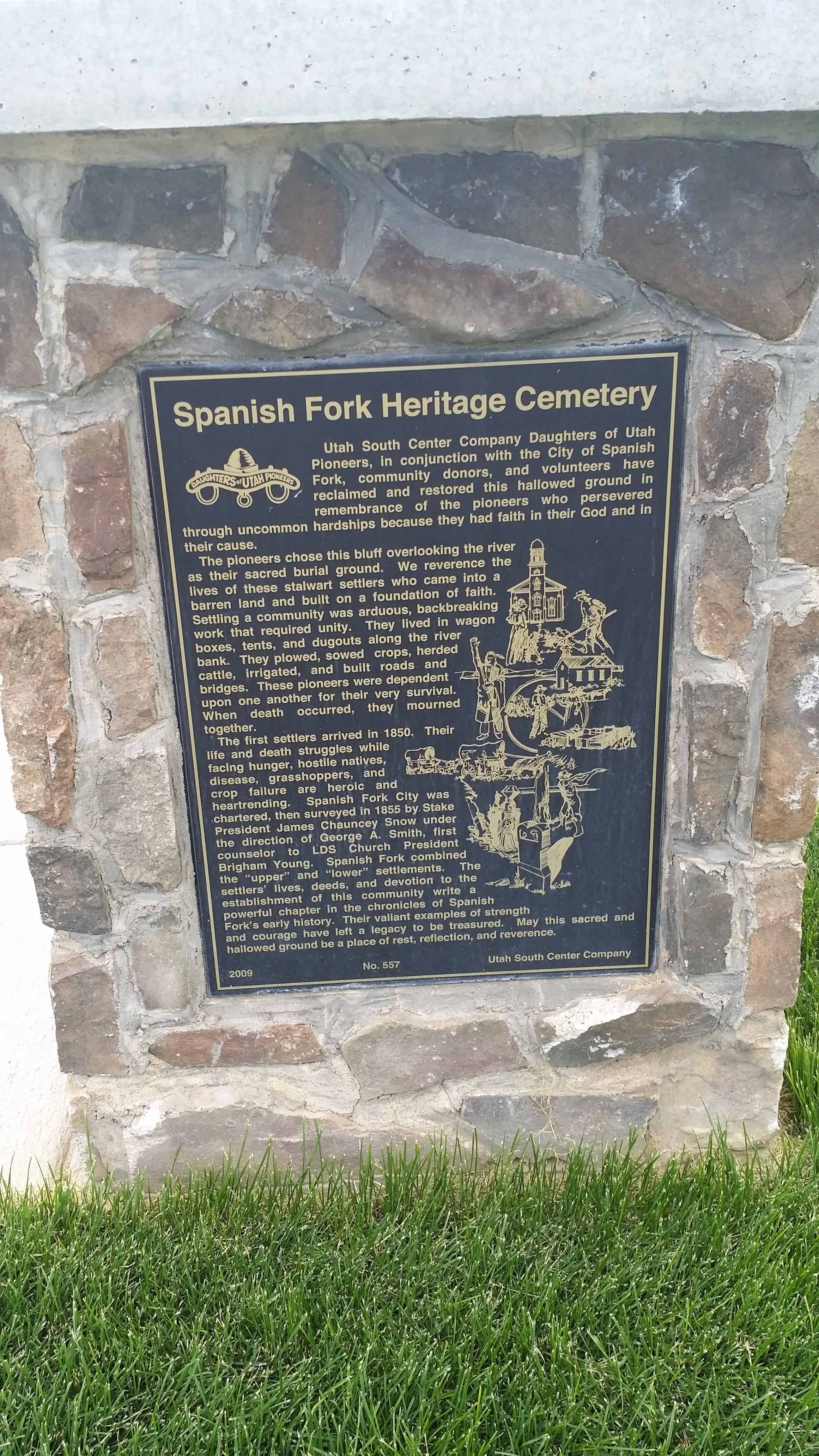
(This is DUP Marker #557, click here for more info)

ImageImageImageImageImageImageImageImage

Cottonwood Settlement

10 Tuesday Jun 2014

Posted by Jacob Barlow in Uncategorized

≈ 1 Comment

Tags

Cottonwood Heights, DUP, historic, Salt Lake County, utah

  • Image

This wooded area, named for the Cottonwood trees, was originally located between Big and Little Cottonwood Creeks, from 13th East to the foothills of the Wasatch Mountains. The Big and Little Cottonwood Canyons were identified by a large Cottonwood tree at the mouth of the north canyon and a smaller one near the mouth of the south canyon. The creeks meandered across the land. Heavy rains and snows created a huge spring runoff in 1862, cutting new channels, which the Pioneer settlers widened and dredged, struggling to tame the creek. They dug many ditches and two canals. Granite from the Little Cottonwood quarry paraded down Vine Street for the construction of the Salt Lake Temple.

As this farming settlement grew southward, distance and swollen creek beds made it difficult to attend church, school and community events outside the Cottonwood area. A branch of the Big Cottonwood Ward was organized for Cottonwood on October 11, 1885; meetings were held in homes, then schools. In 1890, the first school, an existing log cabin on Spring Lane, was taught by Martha Moses. In 1893, Spillett’s Hall, containing the local post office and store, housed the school for a year. In 1894, students attended a one-room log cabin located just behind the present Oakwood School. In 1896, District 37 built a two-room red brick school. A larger four-room Oakwood School was completed in 1913. Businesses were scattered along Highland Drive.

Big Cottonwood Ward was divided on February 12, 1911, creating Holladay and Brinton Wards. Albert Quist became Bishop, with Edward C. Bagley and Ensign Woodruff serving as counselors. Brinton Ward continued to meet in the school until December 10, 1914, when the chapel was ready. From Ensign Woodruff’s journal (son of President Wilford Woodruff): “I was the contractor… With Fred Smith’s team and my plow, we broke ground… My brother, John, donated the ground…” As the very first chapel built entirely by voluntary labor and contributions, the Brinton Ward building was dedicated by President Heber J. Grant on February 12,1928, as the Cottonwood Ward. The settlement of Cottonwood became known as a ward of Salt Lake City.

2011 No. 562 Salt Lake Olympus Company

  • Image

Gilmer and Salisbury Overland Stage Company

10 Tuesday Jun 2014

Posted by Jacob Barlow in Uncategorized

≈ 2 Comments

Tags

DUP, Hatton, historic, Millard County, utah

picture27sep08-002

Gilmer and Salisbury Overland Stage Company

The town of Hatton was settled in 1854 on the old immigrant trail leading to southern California.  This site identifies one of the stops the Gilmer and Salisbury Overland Stage made on the way from Salt Lake City, Utah to Pioche, Nevada, and on to the coast.  Jack Gilmer and Monroe Salisbury purchased the Utah line of Wells, Fargo & Co. and renamed it.  By 1880 they became one of the most powerful corporations in the West.

Two spans of horses pulled the heavy stage to the Hatton “Home Station” operated by William George.  Frederick M. Bird, Sr. was the caretaker for the horses, and Orson Whitaker was one of the first drivers.  They would ready the fresh horses at the sound of a bugle, blown when the stage was within one mile.  Refreshments for passengers were provided at the Bird home.

Farming was the main occupation for the settlers, and the stage line provided additional revenue.  John Ormond had a store beside the station that sold merchandise, including candy that his wife made.  George Hickerson had a thriving business selling feed, hay, and grain to immigrants traveling to California.

Peter Robison, one of the first settlers, originally named the town Corn Creek.  When he became postmaster, the town was renamed Petersburg.  A few years later, Richard Hatton became postmaster, and the town was named Hatton.

As the town grew, Cornelia Robison taught school in the Robison home.  Later Henry Young and William Dameron were teachers.  A building was erected in 1867 that served as a school and a church meeting place.

Brigham Young, President of The Church of Jesus Christ of Latter-day Saints, advised the settlers in 1867 to move farther up Corn Creek to conserve water, utilize more fertile soil, and avoid early frosts.  Several families heeded his advice, but some stayed.  After the railroad came, the stage line was sold and business declined.  In a few years, Hatton was almost deserted.

picture27sep08-001

Check out all of the historic markers placed by the Daughters of Utah Pioneers at JacobBarlow.com/dup

← Older posts
Newer posts →

Follow Jacob

Follow Jacob

Blog Stats

  • 2,064,964 hits

Social and Other Links

BarlowLinks.com

Recent Posts

  • The Heinrich Gubler Home
  • The Temple Quarry
  • The Old Settler’s “Swallow’s Nest”
  • Arthur Miles Home
  • Navajo Shadehouse Museum

Archives

Loading Comments...