• About JacobBarlow.com
  • Cemeteries in Utah
  • D.U.P. Markers
  • Doors
  • Exploring Utah Email List
  • Geocaching
  • Historic Marker Map
  • Links
  • Movie/TV Show Filming Locations
  • Oldest in Utah
  • Other Travels
  • Photos Then and Now
  • S.U.P. Markers
  • U.P.T.L.A. Markers
  • Utah Cities and Places.
  • Utah Homes for Sale
  • Utah Treasure Hunt

JacobBarlow.com

~ Exploring with Jacob Barlow

JacobBarlow.com

Tag Archives: utah

Salt Lake City’s Historic Districts

02 Sunday Feb 2020

Posted by Jacob Barlow in Uncategorized

≈ 3 Comments

Tags

Historic Districts, NRHP, Salt Lake City, Salt Lake County, utah

(the above image is from slc.gov)

Salt Lake City has 13 historic districts listed on the National Register of Historic Places.

  • Avenues Historic District
  • Bennion-Douglas
  • Bryant
  • Capitol Hill Historic District
  • Central City Historic District
  • City Creek Canyon Historic District
  • Exchange Place Historic District
  • Gilmer Park Historic District
  • Liberty Wells Historic District
  • Northwest Historic District
  • South Temple Historic District
  • U of U Circle Historic District
  • University Neighborhood Historic District
  • Westmoreland
  • Yalecrest Historic District

Related Posts:

  • Neighborhoods of Salt Lake City
  • Salt Lake City, Utah
  • Utahโ€™s Historic Districts

State Street SLC

01 Saturday Feb 2020

Posted by Jacob Barlow in Uncategorized

≈ 18 Comments

Tags

Salt Lake City, State Street, State Street SLC, utah

I make a page for each city where all of the posts of places in that city are listed by address for those times when I need to find a post and I can remember where it was but not the name or some similar situation.

Salt Lake Cityโ€™s page was getting so long I decided to split it up.

  • โ€œWestโ€ Streets
  • โ€œEastโ€ Streets
  • โ€œNorthโ€ Streets
  • โ€œSouthโ€ Streets
  • The Avenues area
  • Capitol Hill Historic District
  • State Street
  • Main Street
  • Named Street and Other

– West side of State Street (North to South) – – East side of State Street (North to South) –
350 N State St – Utah State Capitol350 N State St – Utah State Capitol
300 North300 North
86-88 E 300 N300 N State St – Old City Hall, Now Known As Council Hall
279 N State St264-268 N State St
269 N State St250 N State St
259 N State St
79 Hillside Avenue
Hillside AvenueHillside Avenue
233 N State St232-234 N State St
214 N State St โ€“ Brooks-Snyder Home
225 N State St โ€“ Woodruff-Riter Mansion210 N State St โ€“ Ellerbeck Home
208 N State St
204 N State St โ€“ Miller-Geoghegan Home
200 NorthEast Capitol Street
78 E 200 N180 N State St โ€“ Gallacher Home
169 N State St170 N State St โ€“ Cannon Home
163 N State St โ€“ Bailey Home158 N State St โ€“ Ashby Snow Home
161 N State St
157 N State St
151 N State St
145 N State St โ€“ William Bernard Dougall Jr. Home
125 N State St110 N State St – City Creek Park
61 E North Temple
North Temple2nd Avenue
47 E South Temple – LDS Church Office Building115 E First Avenue โ€“ Brigham Young Historic Park
63 E South Temple – The Bee-Hive House113 E First Avenue
1st Avenue
40 N State St
109 E South Temple โ€“ Eagle Gate Apartments
1 N State St โ€“ Eagle Gate1 N State St โ€“ Eagle Gate
 South Temple South Temple
100 E South Temple โ€“ Alta Club
6015 S State St
29 S State St – The Belvedere Apartments
36 S State St45
61 S State St
69 S State
70 S State St – Mountain States Telephone & Telegraph Building95 S State St
100 South100 South
120 S State St – Federal Reserve Bank
125 S State St – Wallace F. Bennett Federal Building
132 S State St – Orpheum Theatre139 S State St
140 S State St – Cooperative Wagon and Machinery Company
150 S State St151 S State St
156 S State St
158 S State St also the Empire Theater
160 S State St – Liberty Theater
89 E 200 S185 S State St – Maverik HQ
200 South200 South
222 S State St – Salt Lake City Marriott City Center215 S State St
245 S State St
268 S State St – Brooks Arcade299 S State St – See: 111 E 300 S
300 South300 South
324 S State St311 S State St
328 S State St
338 S State St333 S State St
342-350 S State St
Exchange Place
360-368 S State St
370/372 S State St
73-75 E 400 S โ€“ Hotel Plandome375 S State St
400 South400 South
450 S State St – Scott M. Matheson Courthouse449 S State St – Washington Square
451 S State St – Salt Lake City and County Building
500 South500 South
555 S Main St – The Grand America Hotel525 S State St
543 S State St
575 S State St
600 South600 South
90 Eย 600 S601 S State St
Gregory Place623 S State St
638 S State St625 S State St
627 S State St
629 S State St
640 S State St635 S State St
650 S State St645 S State St
660 S State St651 S State St
662 S State St657 S State St
666 S State St665 S State St
680 S State St675 S State St
700 South700 South
722 S State St711 S State St
730 S State St735 S State St
745 S State St
755 S State St
754 S State St – Sears777 S State St
800 South800 South

  • 801 S S State St
  • 810 S State St – Taco Time
  • 825 S State St
  • 830 S State St
  • 843 S State St
  • 850 S State St
  • 854 S State St
  • 855 S State St
  • 858 S State St
  • 864 S State St
  • 865 S State St
  • 877 S State St
  • 888 S State St

  • 905 S State St
  • 917 S State St
  • 923 S State St
  • 927 S State St
  • 935 S State St
  • 958 S State St
  • 961 S State St
  • 999 S State St

  • 1004 S State St
  • 1010 S State St
  • 1016 S State St
  • 1049 S State St
  • 1050 S State St
  • 1081 S State St
  • 1083 S State St
  • 1084 S State St
  • 1090 S State St
  • 1095 S State St

  • 1102 S State St
  • 1107 S State St
  • 1111 S State St
  • 1115 S State St
  • 1121 S State St
  • 1122 S State St
  • 1125 S State St
  • 1135 S State St
  • 1136 S State St
  • 1139 S State St
  • 1147 S State St
  • 1148 S State St
  • 1158 S State St
  • 1165 S State St
  • 1169 S State St
  • 1185 S State St – Uptown Motel
  • 1190 S State St
  • 1200 S State St
  • 1207 S State St
  • 1212 S State St
  • 1220 S State St
  • 1301 S State St – Coachmans Dinner & Pancake House
  • 1302 S State St – Wayne’s Corner
  • 1324 S State St – Ralphaelโ€™s Church School Museum
  • 1330 S State St
  • 1356 S State St
  • 1374 S State St – Witzels Pawn
  • 1385 S State St
  • 1388 S State St – Bearing & Bushing Supply

  • 1400 S – State Brass Foundry
  • 1435 S State St
  • 1438 S State St
  • 1445 S State St
  • 1446 S State St
  • 1460 S State St
  • 1465 S State St
  • 1470 S State St
  • 1480 S State St
  • 1489 S State St
  • 1492 S State St – Piper Down
  • 1499 S State St

  • 1504 S State
  • 1514 S State
  • 1533 S State
  • 1540 S State St – Midtowne Apartments
  • 1554 S State St – 1554 S State
  • 1575 S State St – Old South High / SLCC
  • 1588 S State St

  • 1650 S State St – Arby’s

  • 1701 S State St
  • 1708 S State St
  • 1716 S State St
  • 1717 S State St
  • 1729 S State St
  • 1749 S State St – Capitol Motel
  • 1760 S State St
  • 1767 S State St – Wasatch Service Station
  • 1785 S State St
  • 1791 S State St
  • 1792 S State St

  • 1815 S State St – Fadel’s Fine Furniture
  • 1816 S State St
  • 1829 S State St – Zions Motel
  • 1899 S State St – Alta Motel Lodge

  • 2001 S State St – County Offices, former hospital
  • 2010 S State St
  • 2014 S State St
  • 2040 S State St
  • 2090 S State St

South of 2100 South is technically in South Salt Lake, Utah

  • 2102 S State St
  • 2115 S State St – Busy Bee
  • 2265 S State St
  • 2500 S State St
  • 2511 S State St
  • 2615 S State St
  • 2783 S State St – Reams
  • 2866 S – The Spiking Tourist Lodge

  • 3028 S State St
  • 3035 S State St
  • 3053 S State St
  • 3054 S State St
  • 3055 S State St – Exotic Kitty
  • 3066 S State St – Temple City Motel
  • 3080 S State St
  • 3081 S State St
  • 3092 S State St
  • 3094 S State St
  • 3106 S State St
  • 3109 S State St
  • 3116 S State St
  • 3125 S State St
  • 3130 S State St
  • 3144 S State St
  • 3147 S State St
  • 3149 S State St
  • 3160 S State St
  • 3165 S State St
  • 3205 S State St
  • 3208 S State St
  • 3430 S State St
  • 3600 S State St – Mi Ranchito Grill
  • 3605 S State St – Children’s Theater
  • 3620 S State St – King Buffet of Salt Lake
  • 3635 S State St – Auto Depot
  • 3638 S State St – RODEO AUTO SLC

Lakeview Tithing Office/Bunnell Creamery

01 Saturday Feb 2020

Posted by Jacob Barlow in Uncategorized

≈ 3 Comments

Tags

Historic Buildings, NRHP, Orem, Provo, Tithing Offices, utah, utah county

Lakeview Tithing Office/Bunnell Creamery

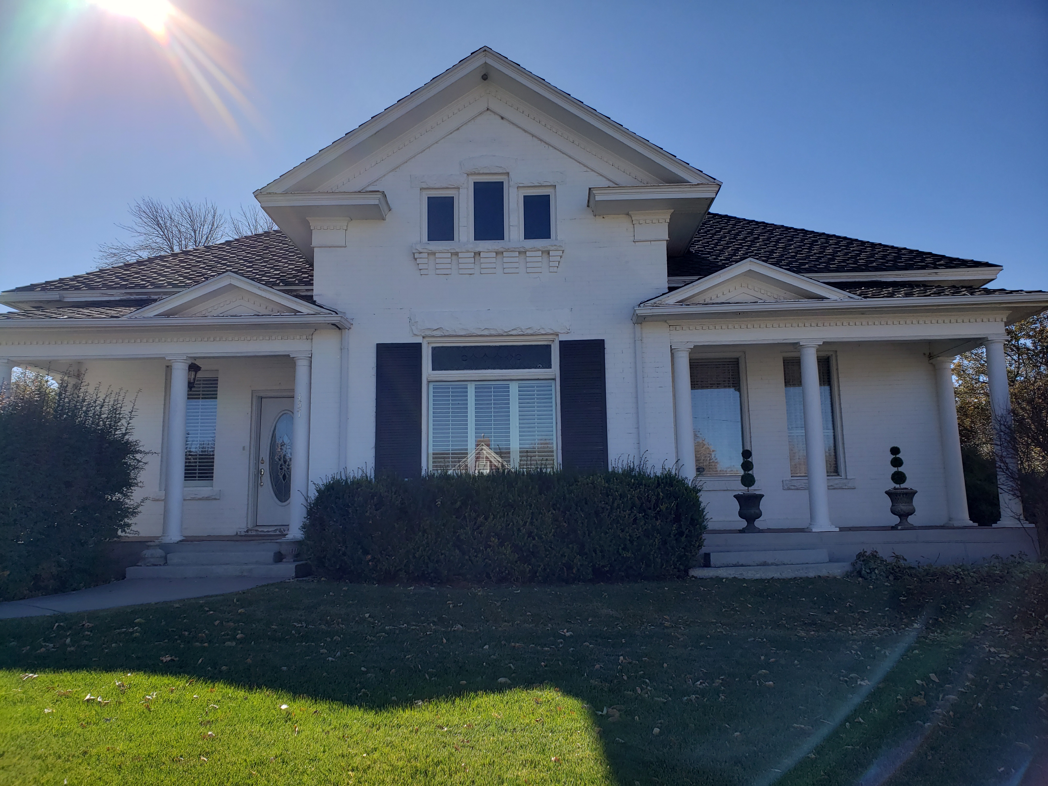
The Lakeview Tithing Office was originally constructed as a creamery by Leslie L. Bunnell in 1899. Leslie and his father, Stephen I. Bunnell, operated a successful dairy operation for a number of years, and this creamery served as the headquarters of their business, which involved making and selling cheese and butter, as well as selling milk. It was the first creamery in Lakeview, a small, unincorporated farming community located between Provo and Utah Lake. The 16’x 16′ room on the west side of the creamery served as the home for the family, which included five children, until 1904, when the adjacent house was built. Soon after that, the Bunnells sold the creamery to the Lakeview Ward of the LDS church for use as a tithing office. The west room was used as an office and the east room served as a storage area for grain and other tithing commodities. The Bunnell family bought the tithing office/creamery back around 1920 and used it for a granary. Occasionally, the west room was used as a residence the last time was during World War II, when a single man lived there for several months. Currently the building is used for storage by the Bunnells.

The Lakeview Tithing Office, built in 1899, is historically significant as one of 28 well preserved tithing buildings in Utah that were part of the successful tithing system of The Church of Jesus Christ of Latter-day Saints (LDS or Mormon church) between the 1850s and about 1910. Tithing lots, which usually included an office and several auxiliary structures, were facilities for collecting, storing, and distributing the farm products that were donated as tithing by church members in the cash-poor agricultural communities throughout the state. Tithing offices were a vital part of almost every Mormon community, serving as local centers of trade, welfare assistance, and economic activity. They were also important as the basic units of the church-wide tithing network that was centered in Salt Lake City.

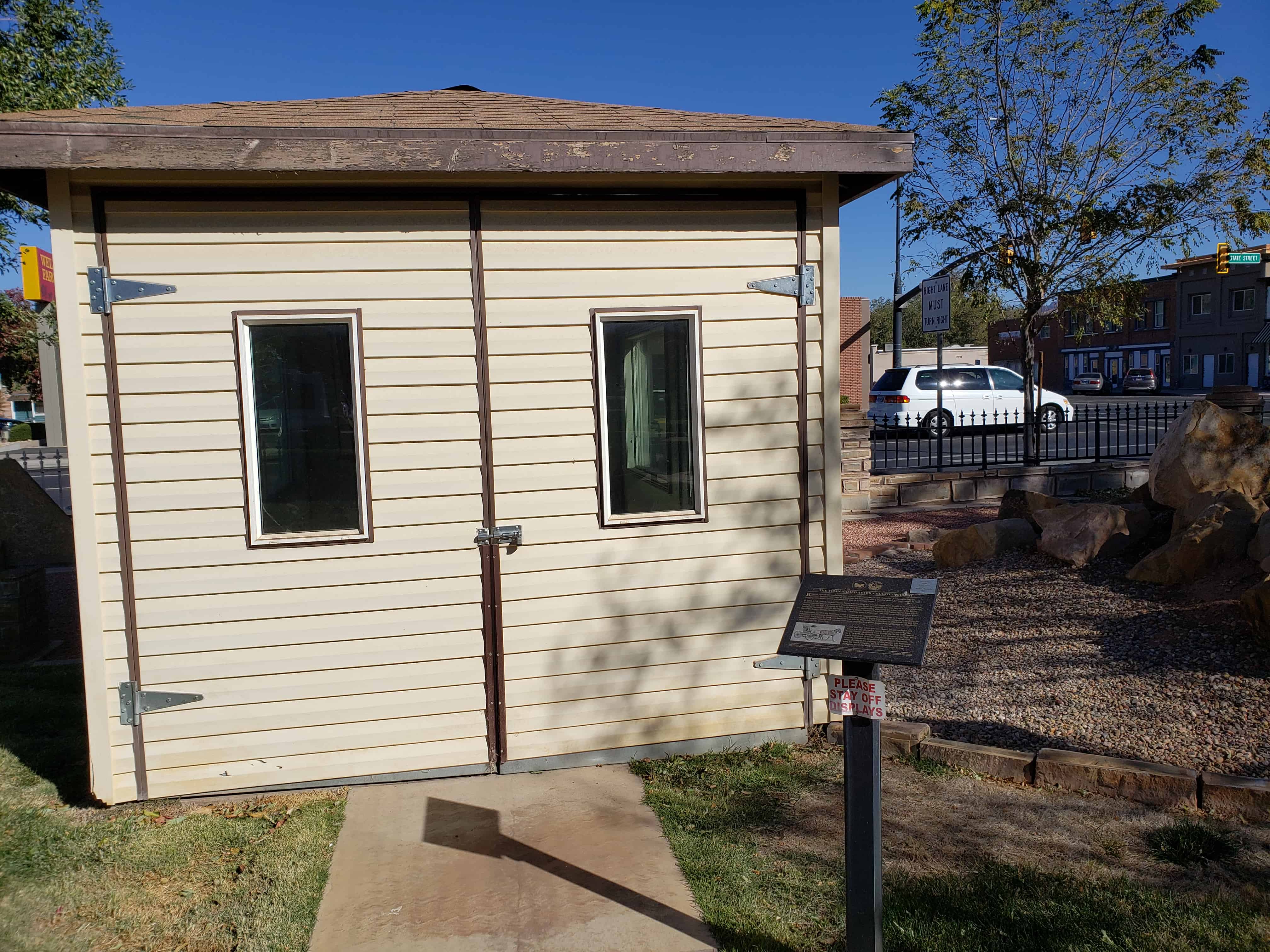
The Lakeview Tithing Office is a one story brick building with a combination gable and hip roof, a stone foundation, and a false front. There is a chimney three quarters of the way down the ridge line. The false front is typical of small town commercial buildings at the turn of the century, as is the corbelling of its upper edge, the jigsaw cut decorative elements in the wooden arches over the facade openings, and the rock-faced shoulder arches over the same openings. The false front is stepped. The facade openings consist of a door centered between two windows. Behind the lower step of the false front on the east side of the building is an extension off the main block of the building. It is a rectangular room with a shed roof and rear entrance, and is situated under the eaves of the main roof. It was probably part of the original construction. According to information in a 1975 Utah Historic Sites Inventory form, it is likely that the room was used to house a boiler that powered the machinery of the creamery. The building has received no major alterations, is in fair condition and maintains its original integrity.

Related Posts:

  • Tithing Offices
  • Lakeview, Utah
  • Historic Registration Form (# 85000289)

Mountain Courtyard Suites

31 Friday Jan 2020

Posted by Jacob Barlow in Uncategorized

≈ 1 Comment

Tags

Abandoned, Salt Lake City, Salt Lake County, utah

I stopped by to document Mountain Courtyard Suites, an apartment building in Salt Lake City that is in poor shape. I’m not sure if they’re going to fix it or knock it down but just in case I like to get photos to be able to look back on.

Related Posts:

  • Residents flee as apartment building shifts

Washington Fields, Utah

31 Friday Jan 2020

Posted by Jacob Barlow in Uncategorized

≈ Leave a comment

Tags

utah, Washington County

Originally Marshalltown, Utah and now an unincorporated area south of Washington, Utah and east of St George, Utah. In the early 1900s there was a brick factory in Marshalltown.

James Simpson House

30 Thursday Jan 2020

Posted by Jacob Barlow in Uncategorized

≈ Leave a comment

Tags

Historic Homes, Mt Pleasant, Sanpete County, utah

James Simpson House

457 West Main
Mt. Pleasant, UT 84647

Constructed c. 1910 for James Simpson, the walls of this double-cross-wing, symmetrical home are three bricks thick. Its facade eclectically combines classical formalism and details, though it is neither fully Neo-classical nor entirely Victorian.

Builders Brandt and Jacobsen used a cement foundation filled with rock, the first in Mt. Pleasant. Locals stood around watching and speculating that it would never last, but today no cracks can be found. The second story is unfinished; the front is unchanged, except for replacing doors on the front porch with windows.

Mr. Simpson died in 1918 during the flu epidemic. Local residents, fearing the ravages of the flu, wanted nothing to do with anything that had come in contact with the disease. Simpsonโ€™s body was passed from the back bedroom through the window and laid out on the front lawn, then placed in a coffin and the lid nailed shut. Just at this time, James Monsen was passing by. Unafraid, he went into the house, took Simpsonโ€™s nine-year-old daughter Dorothy on his lap and comforted her by explaining what was happening.

In 1932 Willis N. and Louise F. Madsen Purchased the house from Simpsonโ€™s daughter Eva and added a screen porch to the back. After Willisโ€™ death in 1932, Louise married Justus O. Seely, then the mayor of Mt. Pleasant.(*)

Related Posts:

  • Historic Homes in Mount Pleasant
  • Mt Pleasant, Utah
Home of James D. Simpson and Rebecca Ruby Beckstrom ~~~ (from our archives)

The Promise of Peoa

30 Thursday Jan 2020

Posted by Jacob Barlow in Uncategorized

≈ Leave a comment

Tags

History, Peoa, summit county, utah

The Promise of Peoa

In May of 1857, an exploring party, under the direction of W.W. Phelps, visited this area seeking locations for future settlements. After selecting this as a place appropriate for such a settlement, he said a prayer of dedication over the area.

Phelps reported in the Deseret News: The place was dedicated, as all the earth will eventually be, for the benefit of Israel, and whoever loves there must love by faith and works in spirit and in truth, for no one else can hope to live there on any other principle.

When settlers arrived three years later in 1860, living close together was necessary for their mutual protection. initially, they built their log homes next to each other, forming a rectangular fort.

This fort was built straddling the creek, thereby providing the occupants with a fresh source of water within the confines of the fort. The creek was thereafter called Fort Creek. The location of this fort is at the present junction of Woodenshoe Lane and State Road 32.

The area to become Peoa was laid out as a town site with each settler taking a strip of land some 12 rods wide, making about 12 acres, running approximately east and west from the road toward the West Hills. (A rod is a unit of measurement 16 1/2 feet.)

On the top of each farm were two buildings lots right next to the road. As the entire town site was not used up, there was a strip on the south end that was divided into what was called “meadow claims” of about 6 acres each. These claims ran perpendicular to the original claims south from what is now Marchant Lane. After these claims were taken (one claim for each family), the portion to the west and south was called “The Undivided” and used in common by the entire community for grazing.

Related Posts:

  • Fort Sage Bottom
  • Peoa, Utah

Warm Creek – Fayette

29 Wednesday Jan 2020

Posted by Jacob Barlow in Uncategorized

≈ Leave a comment

Tags

DUP, Fayette, Historic Markers, Sanpete County, utah

In 1861, Joseph Bartholomew, James Mellor and others settled here and diverted the warm creek for irrigation purposes. A branch of the Church of Jesus Christ of Latter-day Saints was organized in 1862 with Branch Young president. The name of the settlement was changed from Warm Creek to Fayette, honoring the town in New York where the church was first organized. In 1863, John E. Metcalf built the first grist mill on the stream flowing from the warm spring one mile east of this marker. He fashioned and used these mill stones. Fayette Ward was organized July -1877.

D.U.P. Marker # 409

Related Posts:

  • Fayette, Utah
  • Other DUP Markers

Located at 99 South 100 East in Fayette, Utah.

Fayette, Utah

29 Wednesday Jan 2020

Posted by Jacob Barlow in Uncategorized

≈ Leave a comment

Tags

Fayette, Sanpete County, utah

Named after Fayette, New York – Fayette, Utah was previously called Warm Creek.

Related Posts:

  • Dover, Utah
  • Dover Cemetery
  • Park
  • Warm Creek DUP Marker
  • Z.C.M.I. Building
  • Fayette posts sorted by address

The Town Named After A Buggy Incident

27 Monday Jan 2020

Posted by Jacob Barlow in Uncategorized

≈ 1 Comment

Tags

Historic Markers, Hurricane, SUP, utah, Washington County

Located in Hurricane, Utah at the Hurricane Valley Pioneer Heritage Park next to a Carriage House display shelter built by Jaden Ruesch is S.U.P. (Sons of Utah Pioneers) historic marker # 166.

The Town Named After A Buggy Incident

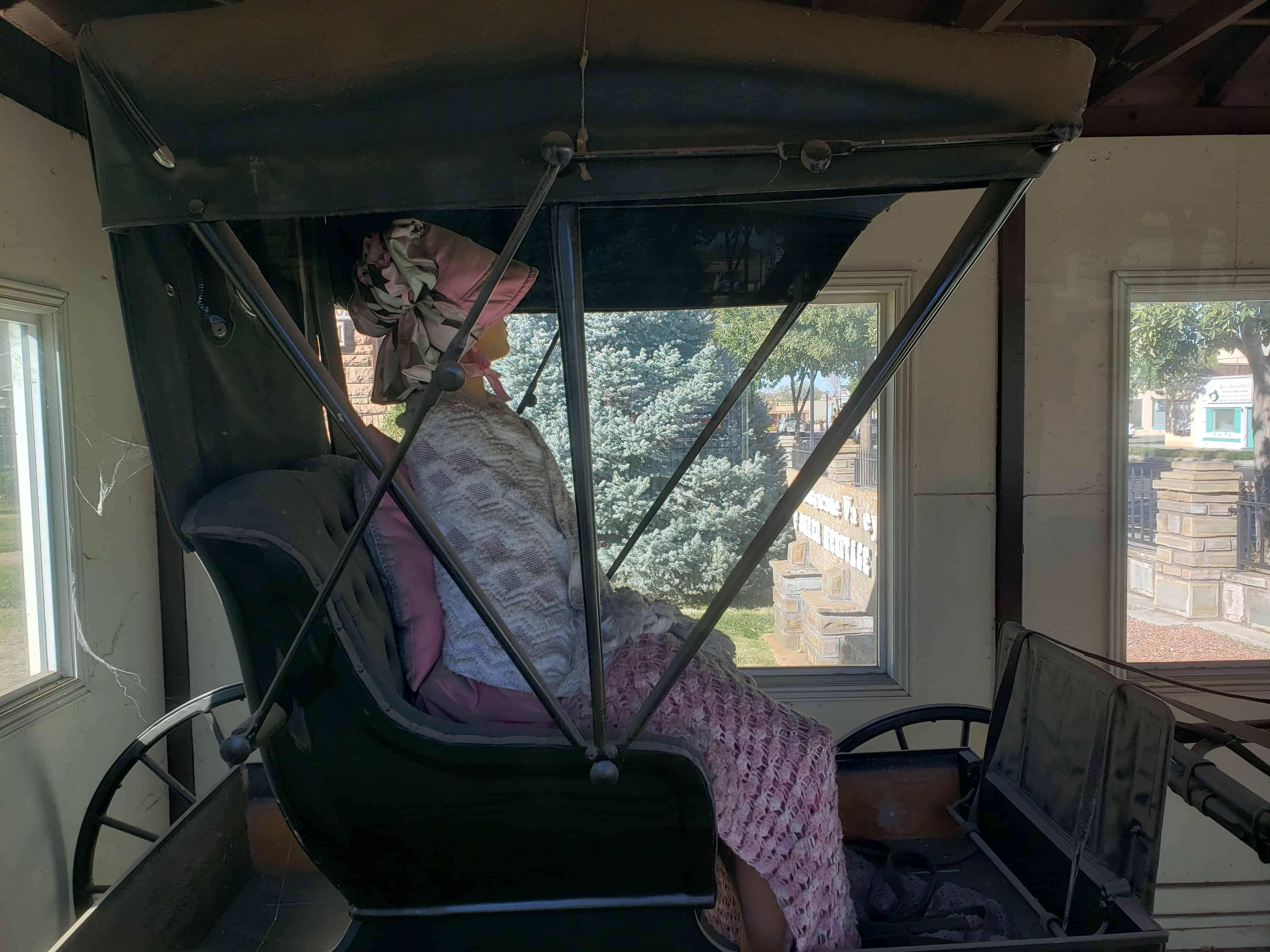
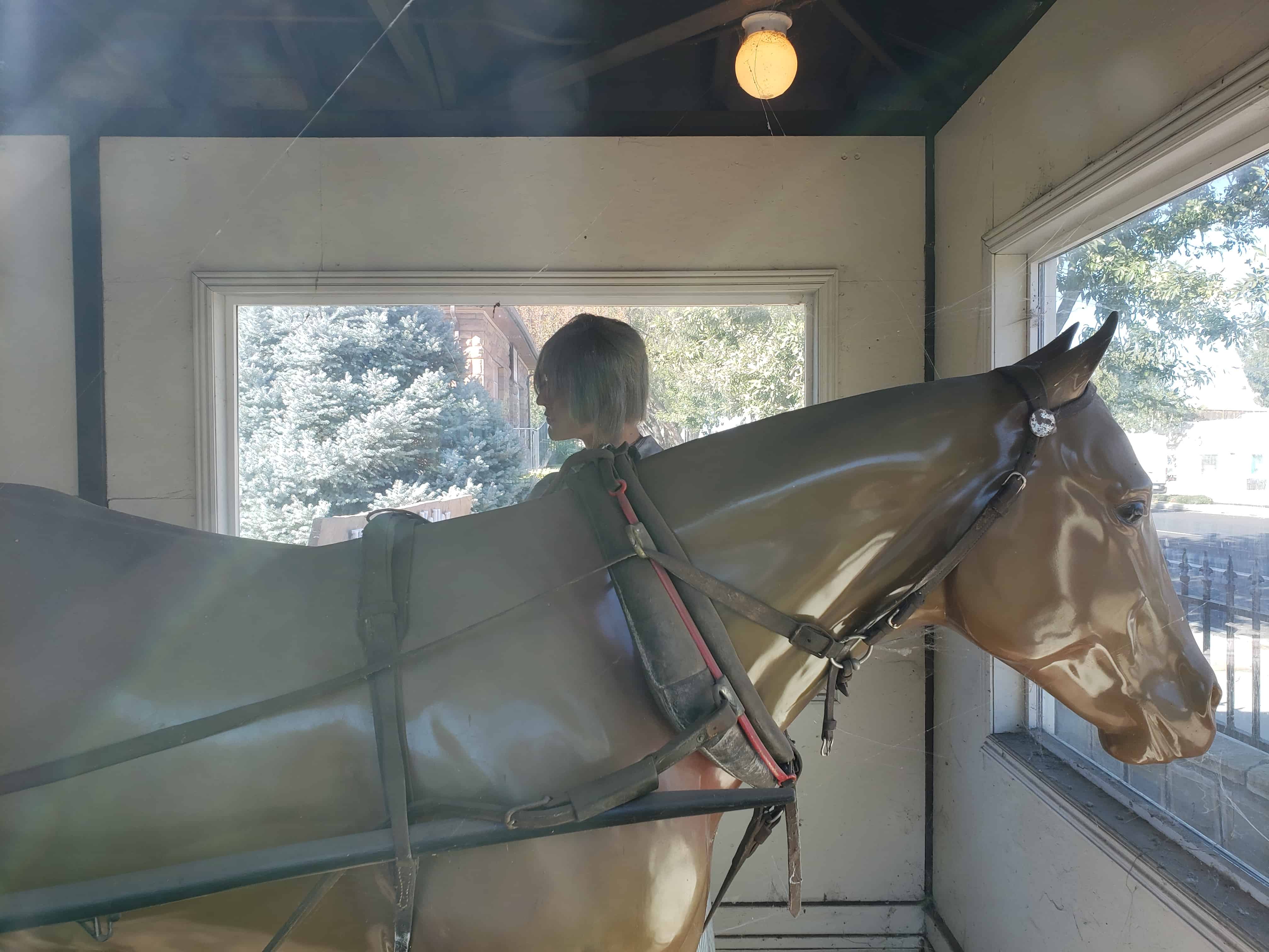
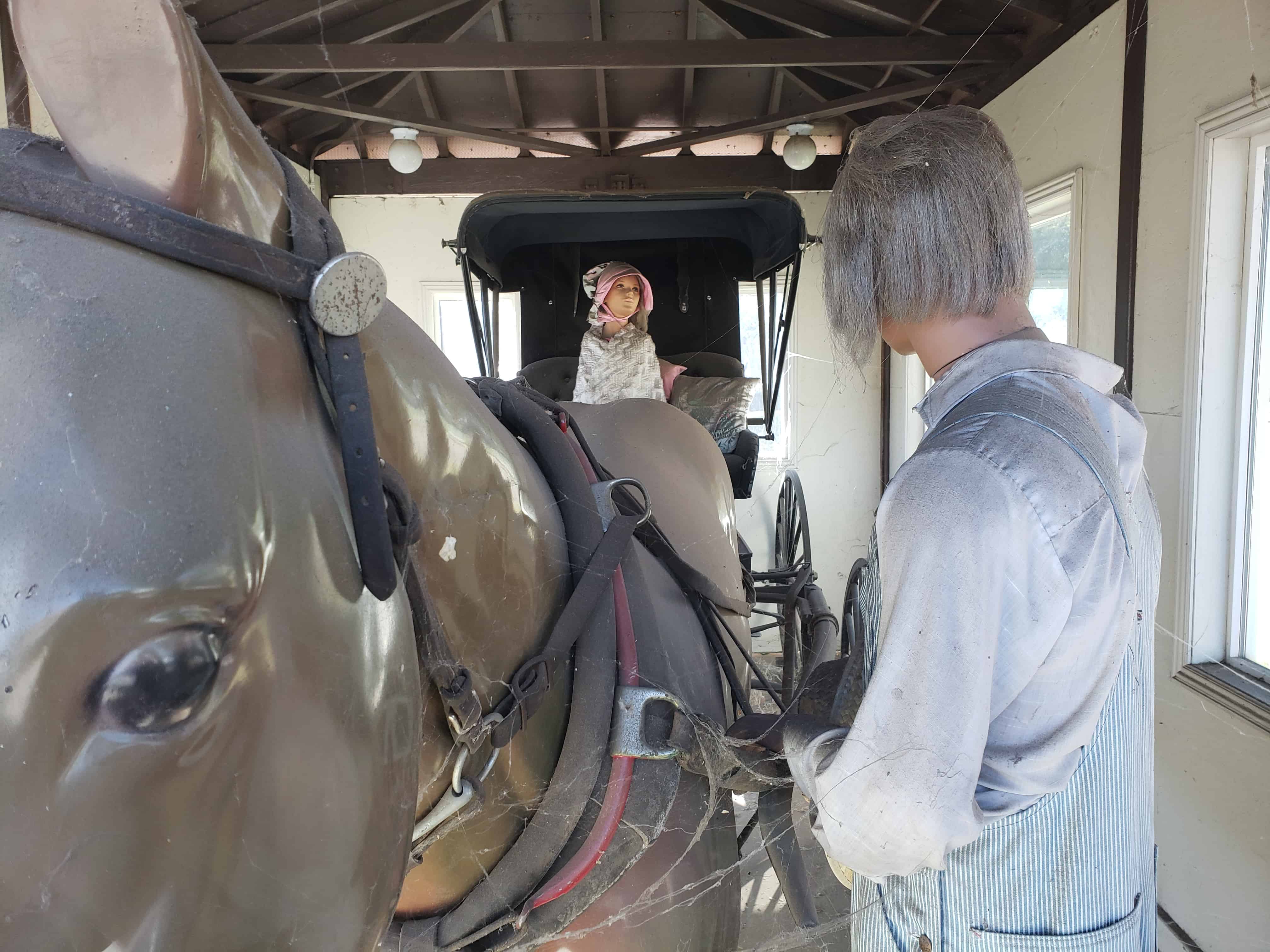
Buggies, such as the one before you, were an important part of early America. As the name implies, Doctors’ Buggies were used by physicians but they were also a popular choice for many others as well. Buggies were dearly prized and generally kept in a carriage house.

In 1863, LDS Church Apostle Erastus Snow was traveling in a similar buggy from Kanab to St. George, Utah. Accompanying him were horsemen (Nephi Johnson and David H. Cannon) who told him of an old Indian trail leading over the hill. Choosing to follow the trail, they successfully descended the other side of the hill by having the horsemen restrain the buggy with their lariats. However, a strong wind came up and blew off the top of the buggy. Erastus Snow exclaimed, “That was quite a hurricane! We will name this Hurricane Hill.”

On September 1, 1893, the Hurricane Canal Company was organized and work began on a canal around Hurricane Hill, ending at Hurricane Flat. Two thousand acres of fertile land could be irrigated by building the new canal. On August 6, 1904, a celebration was held in Hurricane, near the canal at 200 North and 300 East. About 100 people attended and watched with great excitement as water began flowing through the Hurricane Canal and onto the fertile flat.

Later that day, where you now stand, people gather in a bowery on the new town square to choose a name for the town. Names suggested were Pearl City, as the town was to be a “pearl in the desert”, Lake City, because at the time, there was a lake south of town; Chaparral, due to the bush that grew so abundantly throughout the valley; or Hurricane, after the canal company, the hill, and the flat that had used that name since the buggy incident many years before.

← Older posts
Newer posts →

Follow Jacob

Follow Jacob

Come wander with me on Youtube.

Blog Stats

  • 2,106,162 hits

Social and Other Links

BarlowLinks.com

Recent Posts

  • Scout Monument
  • Provo High School Seminary Building
  • 821 E 100 S
  • 820 E 100 S
  • 817-819 E 100 S

Archives

Loading Comments...