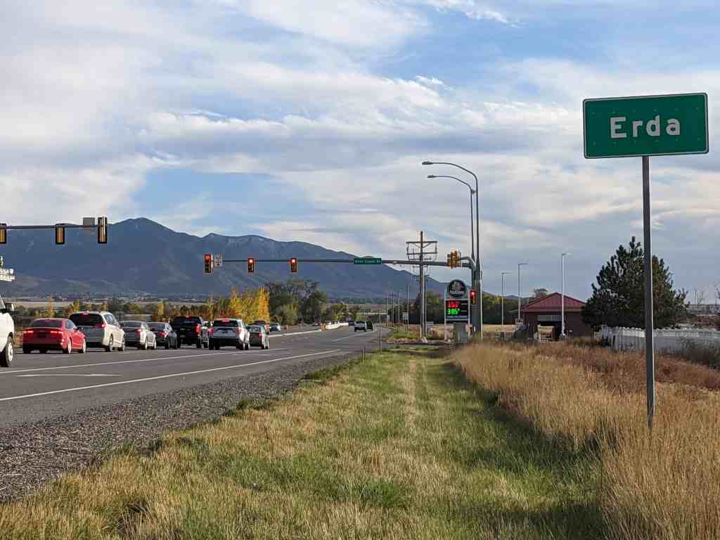
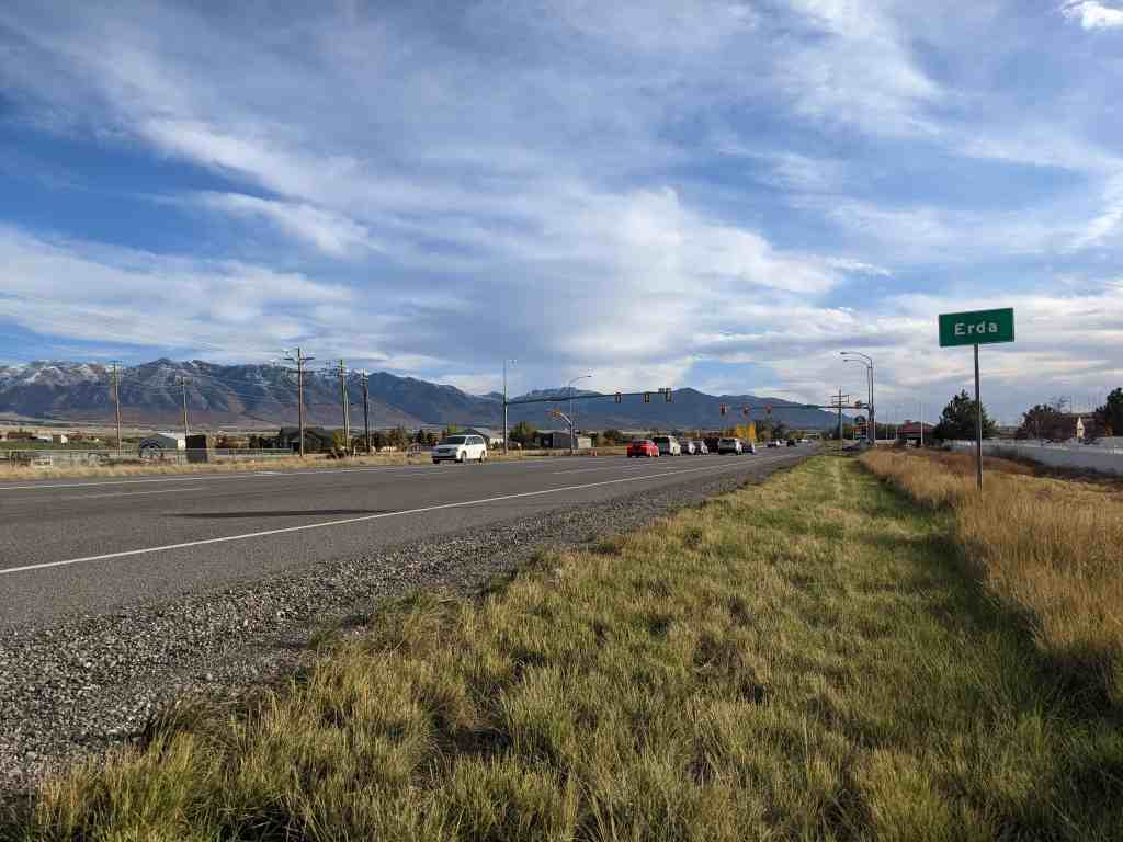
Erda is in Tooele County, Utah located just south of Stansbury Park and just north of the county seat of Tooele. The population was 4,642 at the 2010 census, a significant increase from the 2000 figure of 2,473.
Marilyn Shields, a member of the Daughters of Utah Pioneers who works at the nearby Benson Grist Mill, said there are two stories about how Erda, settled in 1851 and originally called Batesville and Rose Springs, earned its official name.
In one version, Shields says, a wheat and alfalfa farmer named Pierre Apollinaire DeRoubaix, who moved to the area in 1870, called it Erda after a town in France where he once lived. Even though there is no city or town in France named Erda, there is a small village named Erdeven which could have been Pierre Droubay’s home town.
“The other more well-known story is that the San Pedro-Salt Lake Railroad that ran along the Oquirrh Mountains named the town Erda after a German word that means earth,” says Shields.
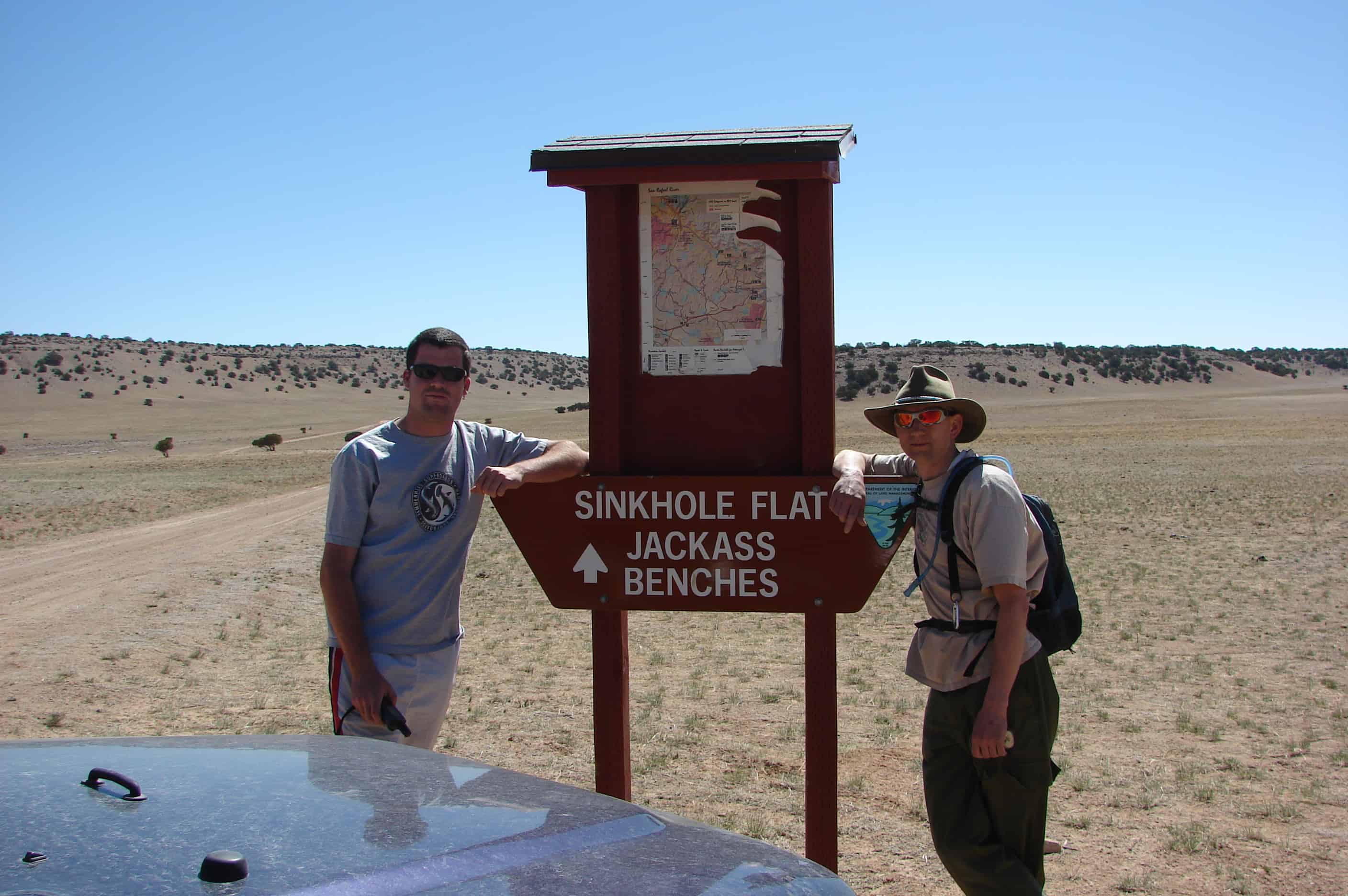
A very dangerous sink hole, about 30 feet in diameter and at least 25 feet deep was discovered on the San Rafael very recently, It was thought to be an old mine shaft which water had gotten into and now has caved in creating a hazardous hole to the surface. A group of off highway vehicle riders found the hole and notified the Bureau of Land Management, who controls most of the land in the San Rafael.
A sinkhole, also known as a sink, shake hole, swallow hole, swallet, doline or cenote, is a natural depression or hole in the surface topography caused by the removal of soil or bedrock, often both, by water. Sinkholes may vary in size from less than a meter to several hundred meters both in diameter and depth, and vary in form from soil-lined bowls to bedrock-edged chasms. They may be formed gradually or suddenly, and are found worldwide.
Mechanisms of formation may include the gradual removal of slightly soluble bedrock (such as limestone) by percolating water, the collapse of a cave roof, or a lowering of the water table. Occasionally a sinkhole may exhibit a visible opening into a cave below. In the case of exceptionally large sinkholes, such as Cedar Sink at Mammoth Cave National Park, USA, a stream or river may be visible across its bottom flowing from one side to the other.
Sinkholes may capture surface drainage for running or standing water, but may also form in currently high and dry locations. The state of Florida in the USA is known for having frequent sinkholes, especially in the central part of the state. The Murge area in southern Italy also has numerous sinkholes. Sinkholes can be formed in retention ponds from large amounts of rain.
Sinkholes are usually but not always linked with karst landscapes. In such regions, there may be hundreds or even thousands of sinkholes in a small area so that the surface as seen from the air looks pock-marked, and there are no surface streams because all drainage occurs sub-surface.
Sinkholes have been used for centuries as disposal sites for various forms of waste. A consequence of this is the pollution of groundwater resources, with serious health implications in such areas.
Sinkholes also form from human activity, such as the rare but still occasional collapse of abandoned mines in places like West Virginia, USA. More commonly, sinkholes occur in urban areas due to water main breaks or sewer collapses when old pipes give way. They can also occur from the overpumping and extraction of groundwater and subsurface fluids.
When sinkholes are very deep or connected to caves, they may offer challenges for experienced cavers or, when water-filled, divers. Some of the most spectacular are the Zacatón cenote in Mexico, the Boesmansgat sinkhole in South Africa, Sarisariñama tepuy in Venezuela, and in the town of Mount Gambier, South Australia.
Out exploring the fields west of the Ogden area I saw a “Welcome to Blossom” sign, I didn’t even know there was one I’ll study up and write what I learn here.
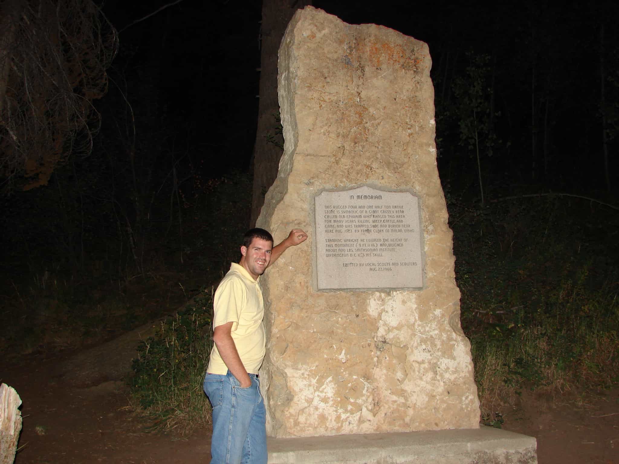
The Grave of a Giant Bear, the stone monument over the grave is as tall as he was ( 9 feet 11 inches ), he weighed 1,100 lbs.
In Memoriam
This rugged four and one half ton native stone is symbolic of a giant grizzly bear called Old Ephraim who ranged this area for many years killing sheep, cattle and game and was trapped, shot, and buried near here Aug. 1923 by Frank Clark of Malad, Idaho.
Standing upright he equaled the height of this monument (9 ft. 11 in.) and weighed about 1,100 lbs. Smithsonian Institute Washington D. C. has his skull.
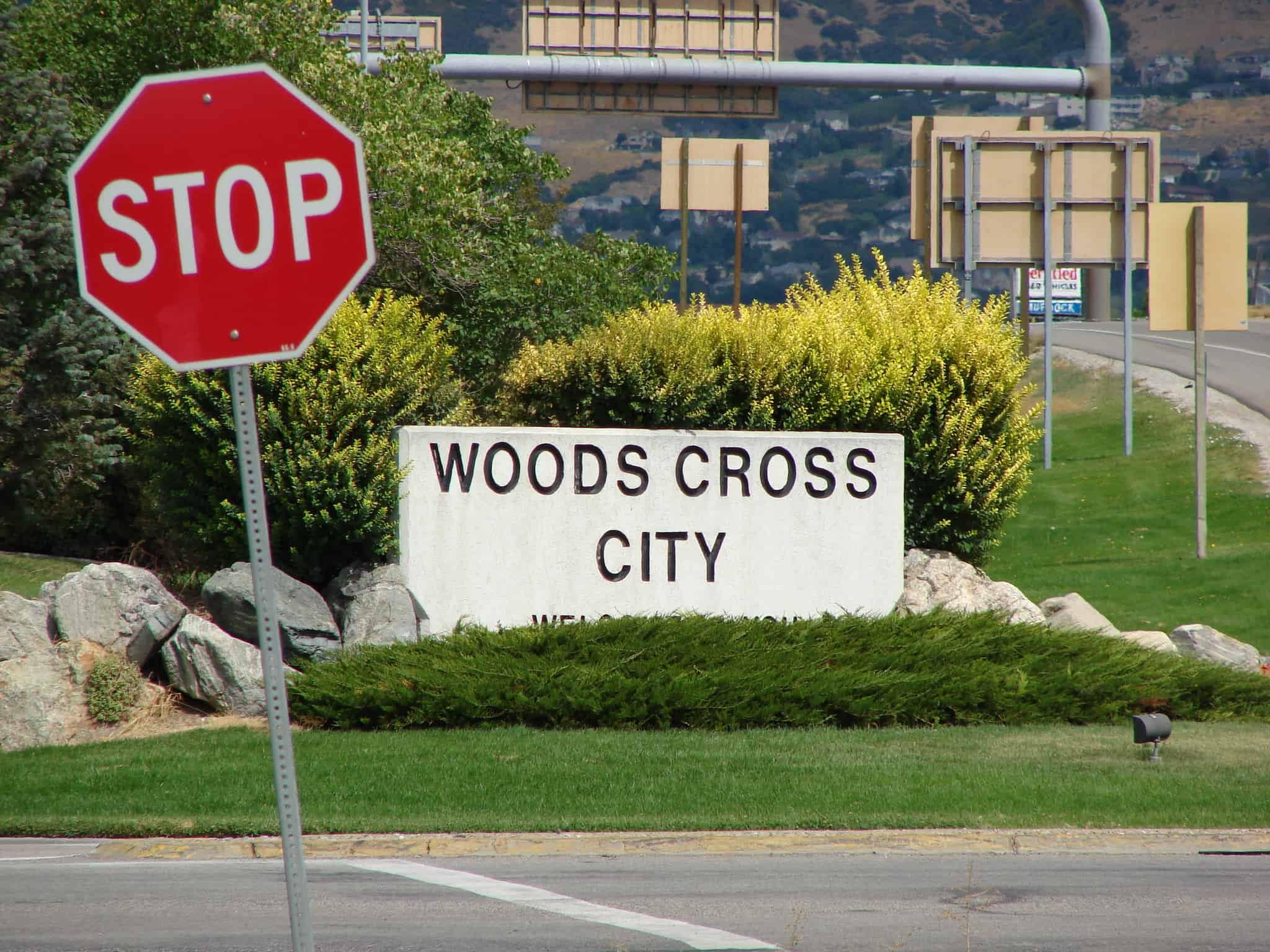
Woods Cross lies near the bottom of the Great Salt Lake Basin, approximately eight miles north of Salt Lake City. It was officially chartered in 1935 by the owners of the Reservoir and Pipeline Company who pooled their Mill Creek water shares and transferred their capital stock and assets to the new city board of trustees. Woods Cross was originally an unincorporated area extending from the southern boundary of Centerville south to the Salt Lake County line and including the areas and communities of Val Verda, Orchard, North Salt Lake, West Bountiful, among others.
In 1847, after the initial Mormon settlement of the Salt Lake Valley, Peregrine Sessions went north to locate pasture lands. He selected a spot near Cudahy Lane, where he spent the winter with is family watching over the herds. The next year, 1848, other settlers arrived and built cellars and dugouts along and near the banks of the Jordan River.
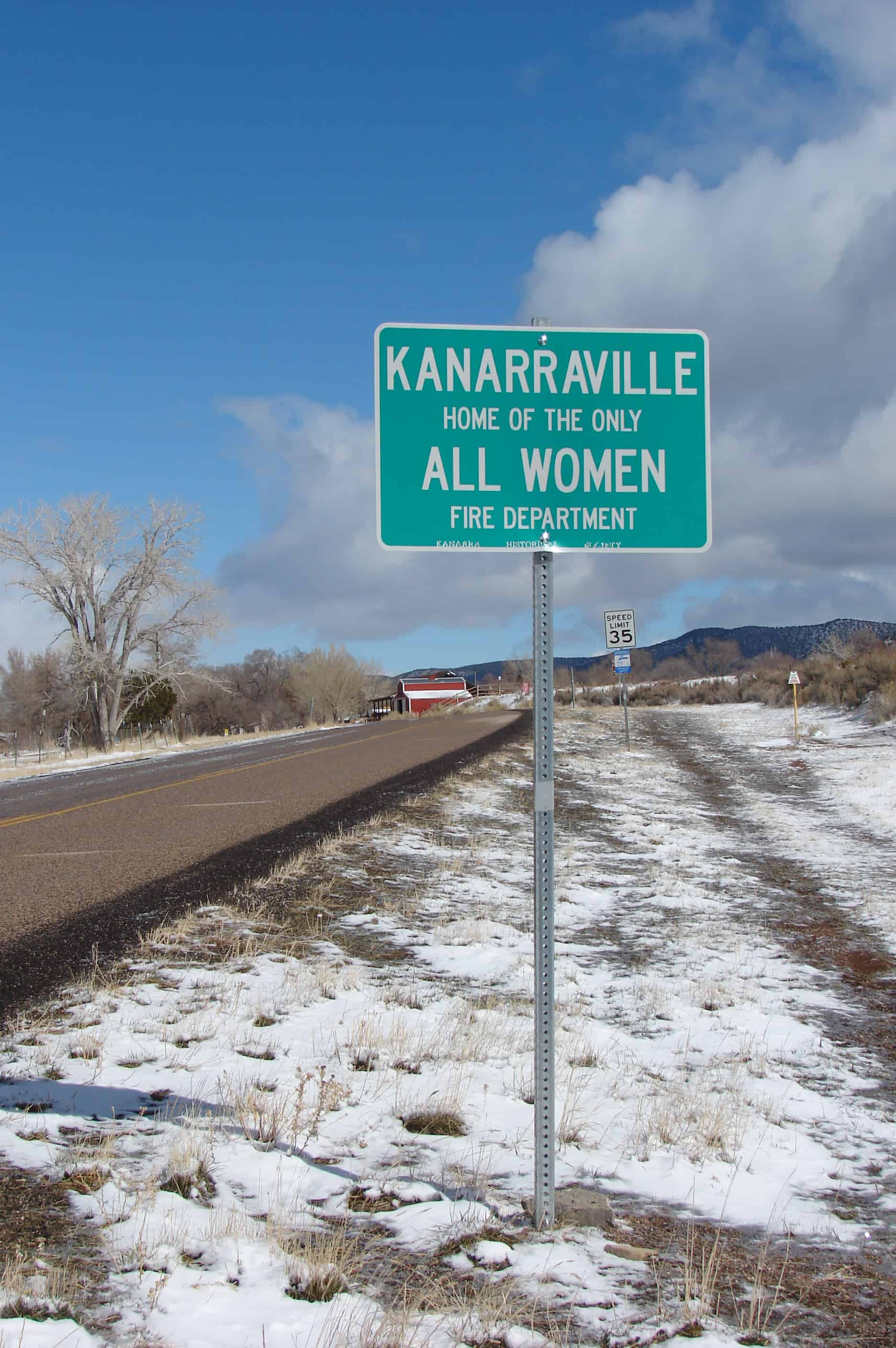
Kanarraville is the home of the only all women fire department.
The town may have acquired its name from either of two sources. The popular belief is that the name came from an Indian Chief, Kuanar, who resided along the creek. Another origin may have been from the kind of willows that grew along the creek, Kanarra Willows.
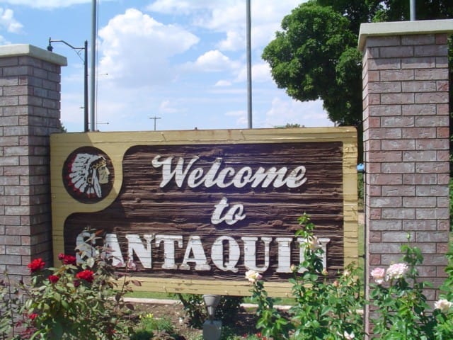
Santaquin is located in Utah County, about seventy miles south of Salt Lake City in a picturesque and beautiful site with a view of Utah Lake and Mount Timpanogos to the north. Originally called Summit City because of its location at the summit dividing line between Utah and Juab valleys, it was settled in late 1851 by pioneers who were helping settle Payson, located about six miles to the north. Abundant water, plenty of fertile land for farming, and abundant groves of trees for firewood, fence posts, and cabin logs made this an ideal place for a community.
A friendship developed between local Indian chief Guffich and Benjamin F. Johnson, leader of the original pioneers, which enabled the whites to settle peacefully in the area. By 1853 the settlement had grown sufficiently to become known as Summit Creek Precinct No. 7. Soon after, however, the Walker War broke out, and the settlers were forced to move for safety to Payson, where they remained until 1855.
Around this time a fort was built according to plans furnished by architect Truman O. Angell. After its completion, the settlers moved back to the town in the spring of 1856. One night soon after resettlement Chief Guffich came secretly to warn Johnson of an impending raid by young braves, including his son Santaquin. The settlers quickly left, and when the raiders found the fort deserted Chief Guffich explained to them that the white men were good people and that the Great Spirit had warned them of the attack. It was claimed that from that day peace was made between the local Indians and the Mormon pioneers. It was decided to name the town after Guffich, but he declined the honor and asked that the settlement be named “Santaquin” for his son.
A rock schoolhouse was built in the fort in 1856. It was stoutly built and served the public for many years, still being used into the 1980s. It was not until 1896 that the first local church building was constructed, religious meetings having been conducted in the school building, which now serves as a senior citizens’ center and a veterans’ memorial hall.
In addition to farming, early industries included sawmills, a flour mill, a molasses mill, and a furniture shop. A silk industry was started with the planting of mulberry trees, some of which still remain in the city. Horse and buggy were the only means of transportation available until 1875, at which time the Utah Southern Railroad completed a line to Santaquin. About that time, rich ore was discovered in the Tintic area. Several mines were discovered on Santaquin ridge, or Dry Mountain, with some copper, lead, silver, and zinc being mined; the Union Chief mine was the most prosperous.
Following serious flooding in 1949, the Summit Creek Canal and Irrigation Company was given approval to construct a reservoir west of the city; on several occasions it has prevented disastrous damage to the community. A diversion dam was completed and more than 10,000 feet of concrete pipe laid in 1971, which proved to be an efficient method of conserving valuable water resources. Irrigation methods changed to sprinkling systems or drip systems, enabling farmers to efficiently irrigate land that was not level, bringing more farmland into production. Natural gas service was brought to Santaquin in 1954, and marked a major development in the modernization of the community.
With the construction of the steel plant at Geneva and the rapid growth in the Provo–Orem area to the north, many fruit farmers relocated to the Santaquin area. Large orchards were planted, replacing wheat fields and pasture land. The construction of huge cold storage facilities for the fruit created many jobs in the community. Another boast to the economy and population came in 1968 with the completion of Interstate 15 through the town.
ESCALANTE TRAIL
Fray Francisco Silvestre Velez De Escalante and Fray Francisco Atanasio Dominguez, two Catholic Priests of the Franciscan Order accompanied by their attendants
Don Juan Pedro Cisneros Lucrecio Muniz
Don Dernardo Miera Y Pacheco Andres Muniz
Don Joaquin Lain Juan De Agulia
Lorenzo Olivares Simon Lucero
Encamped near here September 24, and 25, 1776, to open a wider field for mission work among the Indians. They were seeking an overland route from Santa Fe New Mexico to Monterey California.
These Priests were the first white men to enter what is now the State of Utah and the first to give us a written record of the geography of the country and the character of its people.
THIS STONE
Contributed to Provo City by the children of the Provo City Schools September 25, 1931
See other historic markers in the series on this page for UPTLA/SUP Markers.
“The last remaining vestige of pioneer life in Highland.” – Utah State Historical Society
This log home, built about 1890 and occupied by the Boyd and Louise Stice family from 1926 to 1954 was moved from its original location in west Highland to Heritage Park in 1991. It was deeded to, and restored by, the Highland Camp of the Daughters of the Utah Pioneers.
Welcome to Joe’s Valley, a 75-mile long, north-south trending depression graben, what’s a graben you ask?
Horsts and Grabens
A graben is a depressed block of land bordered by parallel faults. Graben is German for ditch.
A graben is the result of a block of land being downthrown producing a valley with a distinct scarp on each side. Grabens often occur side-by-side with horsts. Horst and graben structures are indicative of tensional forces and crustal stretching.
Graben are produced from parallel normal faults, where the hanging wall is downthrown and the footwall is upthrown. The faults typically dip toward the center of the graben from both sides. Horsts are parallel blocks that remain between grabens, the bounding faults of a horst typically dip away from the center line of the horst.
A single graben or multiple grabens can produce a rift valley.
(Horsts are up thrown blocks bounded on either side by parallel normal faults.)
(Grabens are downthrown blocks bounded on either side by parallel normal faults.)
Half-Graben
Half-grabens develop when parallel faults on either side of a block develop, but the block becomes tilted instead of dropping down as in a graben.