Aaron and Sarah Smethurst homesteaded 160 acres on this site in 1895.
John and Mary Eggett bought the early pioneer farm for $400 in 1902 and raised nine children here. Farm animals, orchards, and a garden provided most of their needs. The Eggett family held all the property until 1959, when part of it became Memorial Estates Cemetery. After the floods in 1983, a landfill bridge was built to the east and the John Eggett family donated three acres to Bountiful City for this park while the remainder was subdivided.
Brick making began early in Bountiful in several areas. The brickyard between 500 and 1500 South and west of 200 West, was operated in turn by the Kirk Brick, Improved Brick, and Bountiful Brick companies, who made more bricks than any other Utah firm. Bountiful Brick Co., owned and operated by John S. and Bertha W. Ledingham, sold the land in 1930, dismantled the kilns, and sold even those bricks. All of the brickyards closed during the Depression.
Anthony W. Ivins was a prominent church and civic leader in early St. George. He served twice in the Presidency of the St. George Stake and Mayor of the City from 1890-1894 in 1895 he was elected as a Washington County representative to the Utah Territorial Constitutional Convention.
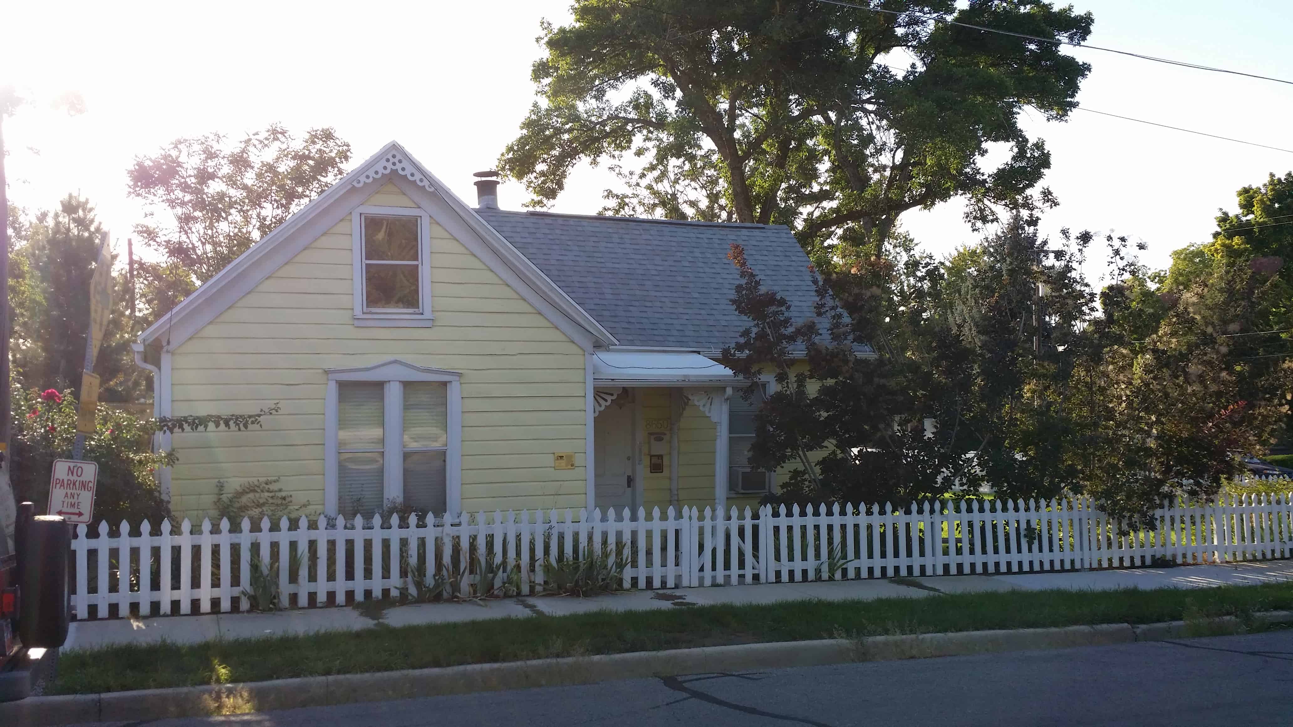
The Sandy Historic District is a Historic District in Sandy, Utah that covers most of the city’s pre-suburbanization extent. It is essentially the area east of State Street, west of 700 East north of 9000 South, and south of Pioneer Avenue (8530 South; near the northern boundary of the city of Sandy). About half of the National Register of Historic Places listings in Salt Lake County outside of Salt Lake City are in Sandy, and the large majority of those are within the Historic District.
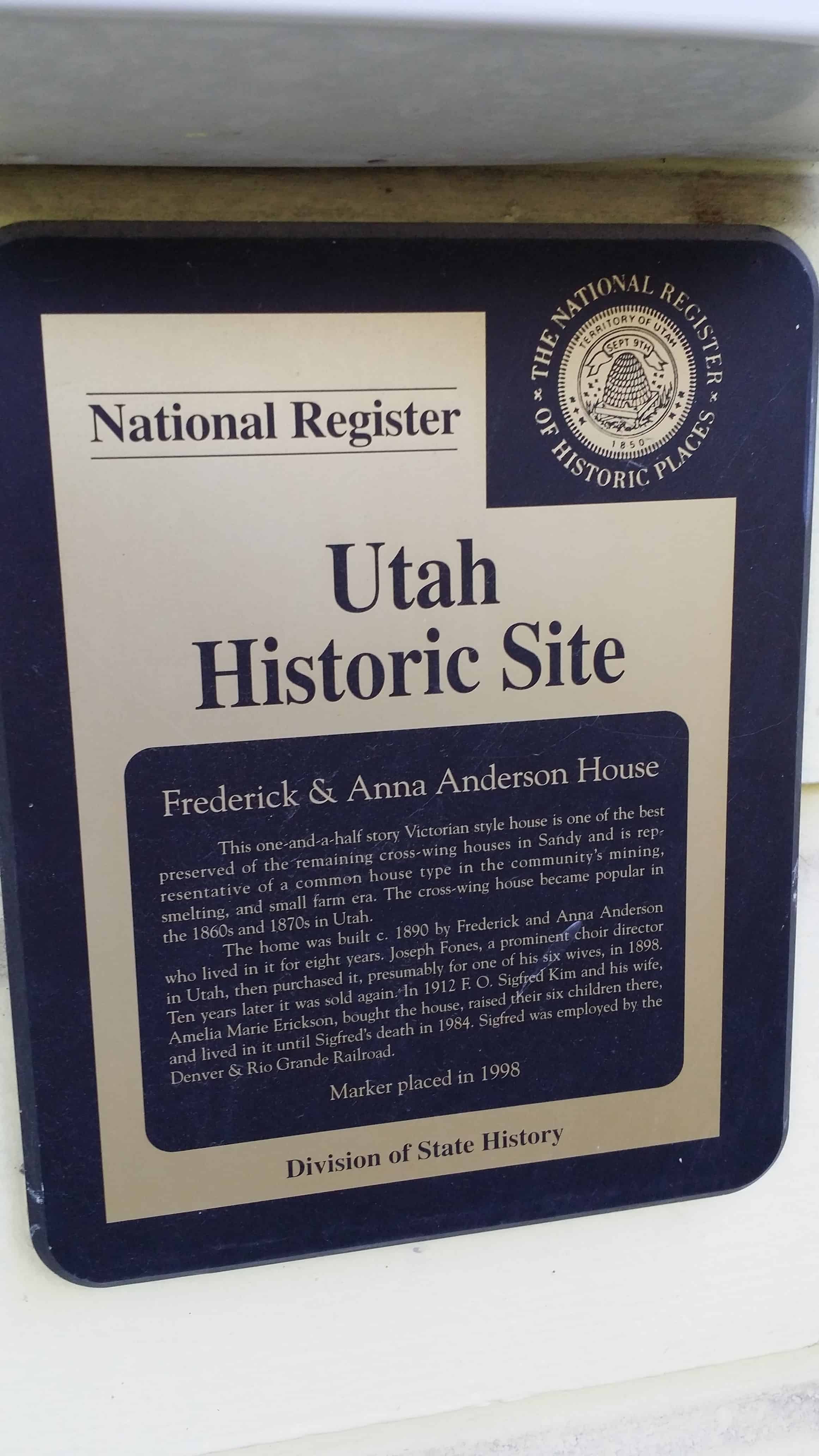
This one-and-a-half story Victorian style house is one of the best preserved of the remaining cross-wing houses in Sandy and is representative of a common house type in the community’s mining, smelting, and small farm era. The cross-wing house became popular in the 1860s and 1870s in Utah.
The home was built c. 1890 by Frederick and Anna Anderson who lived in it for eight years. Joseph Fones, a prominent choir director in Utah, then purchased it, presumably for one of his six wives, in 1898. Ten years later it was sold again. In 1912 F.O. Sigfred Kim and his wife, Amelia Marie Erickson, bought the house, raised their six children there, and lived in it until Sigfred’s death in 1984. Sigfred was employed by the Denver & Rio Grande Railroad.
The above text is from the plaque on the home, placed in 1998. The home is located at 8650 South Center Street in the historic sandy area of Sandy, Utah
The first homesteader on this land was John Kynaston, who acquired it from the U.S. Government for $1.50 an acre in 1870. In 1964, Bountiful City purchased the land from Lola Wilson and Aurelia Olsen. They were grandchildren of the Brown family who had owned and farmed the property from the early 1900’s. The City created Five Points Park as part of its plan to provide green spaces for its citizens.
Hoosier Pass elevation 11,542 ft is a high mountain pass in the Rocky Mountains of central Colorado in the United States. A share of the pioneer settlers being natives of Indiana, the “Hoosier State” caused the name to be selected.
The pass is located on the Continental Divide at the northern end of the Mosquito Range, in a gap between Mount Lincoln (west) and Hoosier Ridge (east). It sits on the boundary between Park (south) and Summit (north) counties.
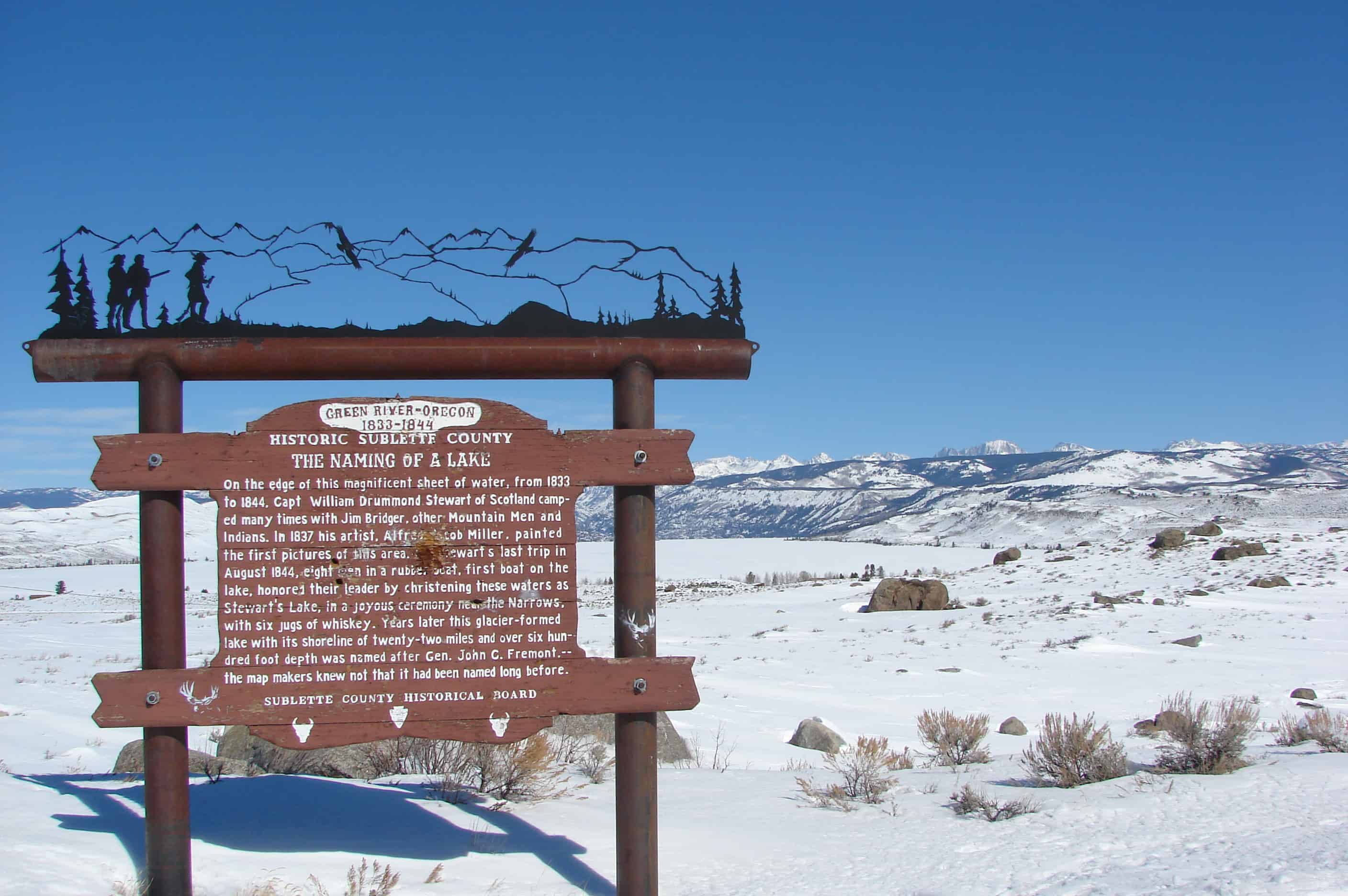
On the edge of this magnificent sheet of water, from 1833 to 1844, Captain William Drummond Stewart of Scotland, camped many times with Jim Bridger and other Mountain Men and the Indians. In 1837 his artist, Alfred Jacob Miller, painted the first pictures of this area. On Stewart’s last trip in 1844, eight men in a rubber boat, first boat on the lake, honored their leader by christening these waters as Stewart’s Lake in a joyous ceremony near the narrows with a jug of whiskey. Years later this glacier-formed lake with its shoreline of twenty-two miles and over six hundred foot depth was named for John C. Fremont, – the map makers knew not it had been named long before.
The marker pictured above has been replaced and the new one says:
Sir William Drummond Stewart of Scotland can be called Wyoming’s first tourist. Stewart attended every summer rendezvous from 1833 to 1838, during the heyday of the mountain man fur trade. Four of those gatherings took place nearby, at the confluence of Horse Creek and the Green River.
This magnificent glacier-carved lake must have been one of Stewart’s favorite spots. Artist Alfred Jacob Miller accompanied Stewart in 1837 and painted the first pictures of the area, including the mountain lakes that inspired both men.
Although the last rendezvous was held in 1840, Stewart and mountain man William Sublette returned one more time in 1843. They camped here for 10 days in August, visited old Shoshone Indian and trapper friends, and raced horses on a flat to the west near the New Fork River. Stewart and a small party floated to the head of the lake in an India-rubber boat brought especially for that purpose. At that time this lake was called both Stewart’s Lake and Loch Drummond.
The year before, in 1842, explorer John C. Fremont had made his first trip west, and guided by Kit Carson, climbed what he thought was the highest summit in the Wind River Mountains. This peak, which towers over the lake, was later named Fremont’s Peak. Long after, not knowing that the lake had already been named in honor of Stewart, Fremont supporters named it Fremont Lake even though John C. Fremont had never actually been there.
At 9 miles long, 1 mile wide and 600 feet deep, Fremont Lake is the second largest natural lake in Wyoming.