
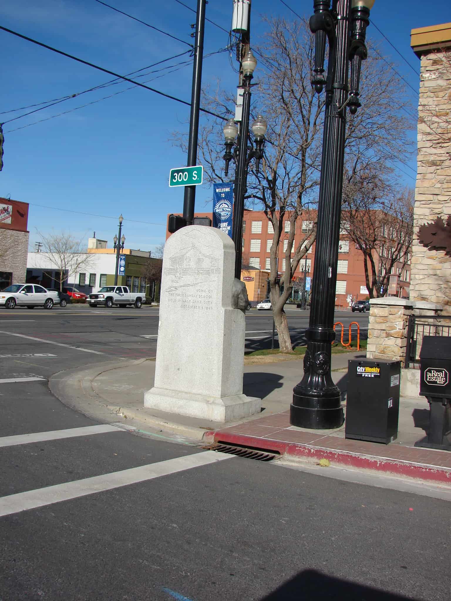
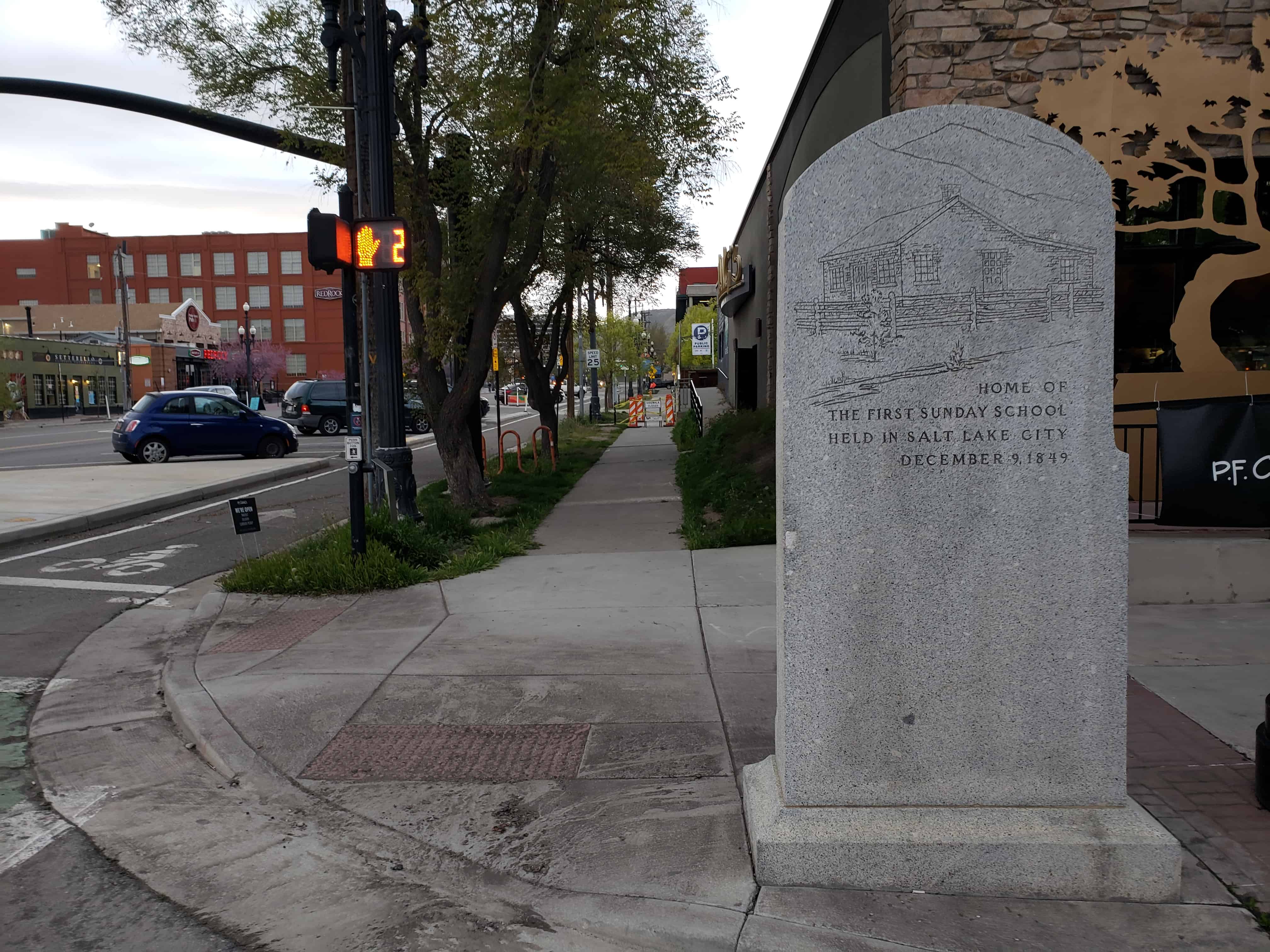
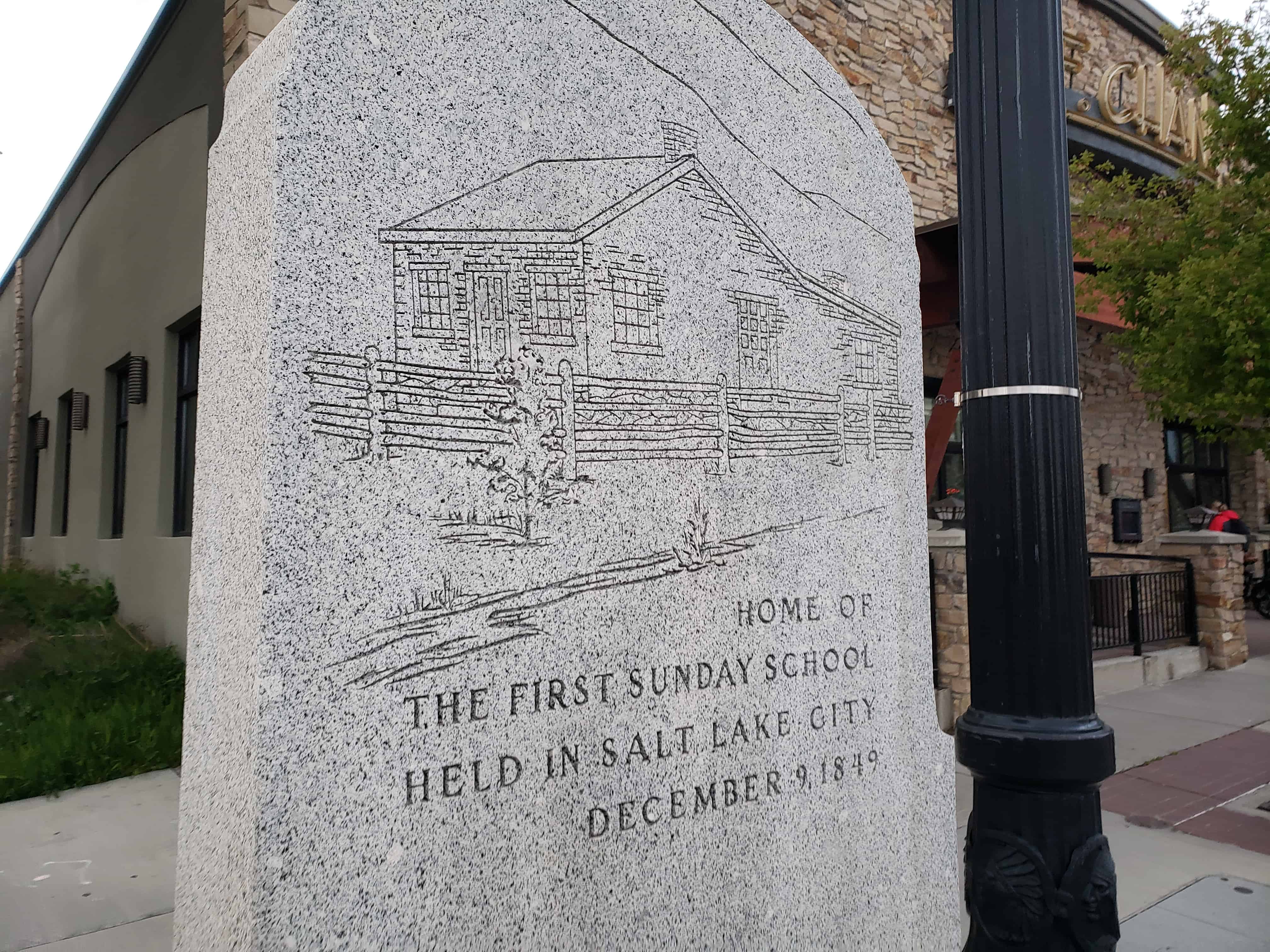
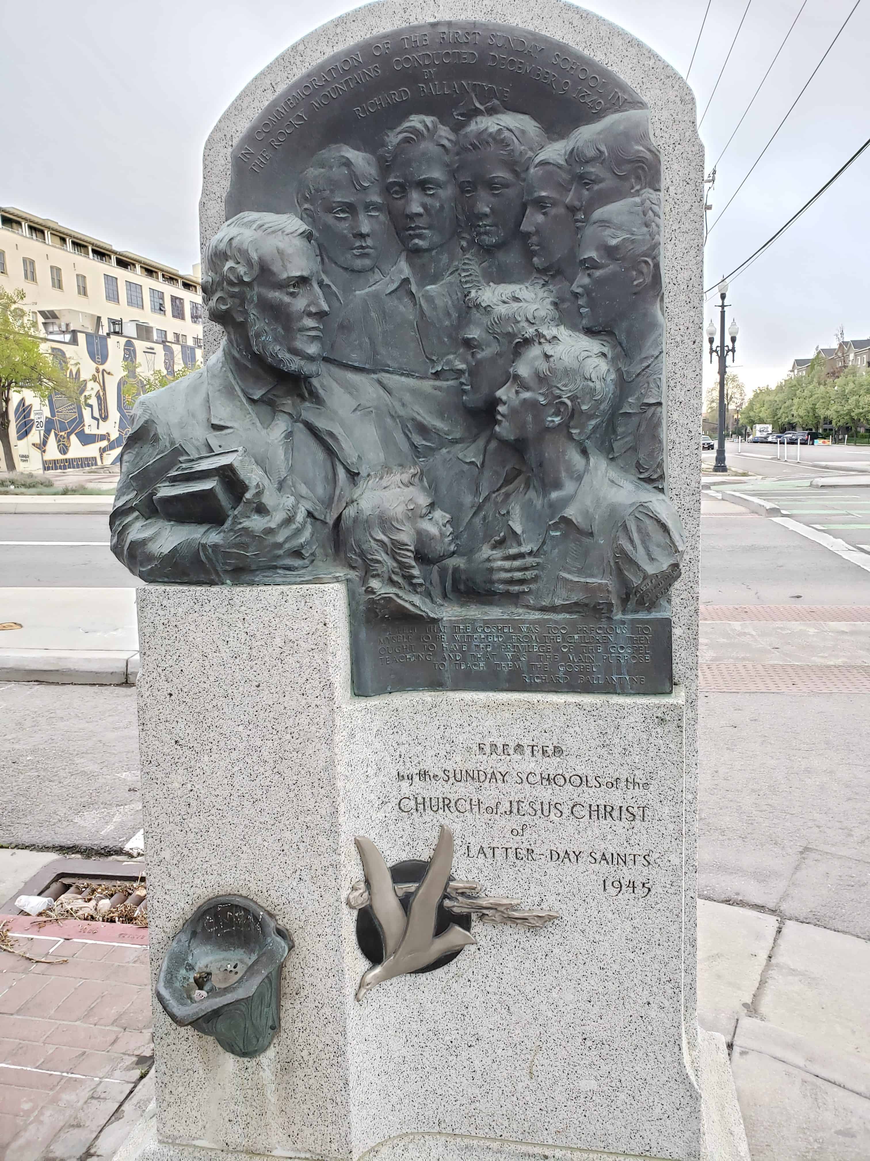
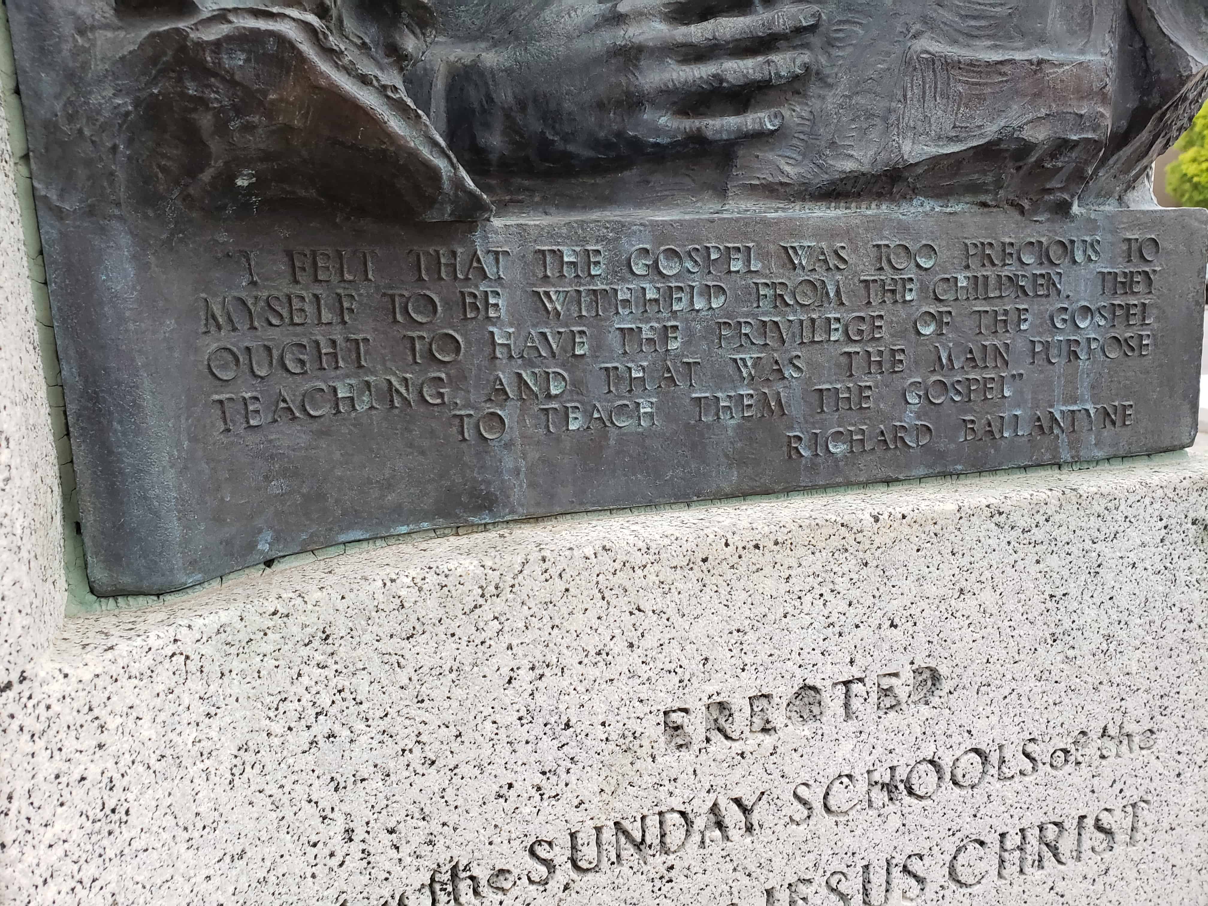
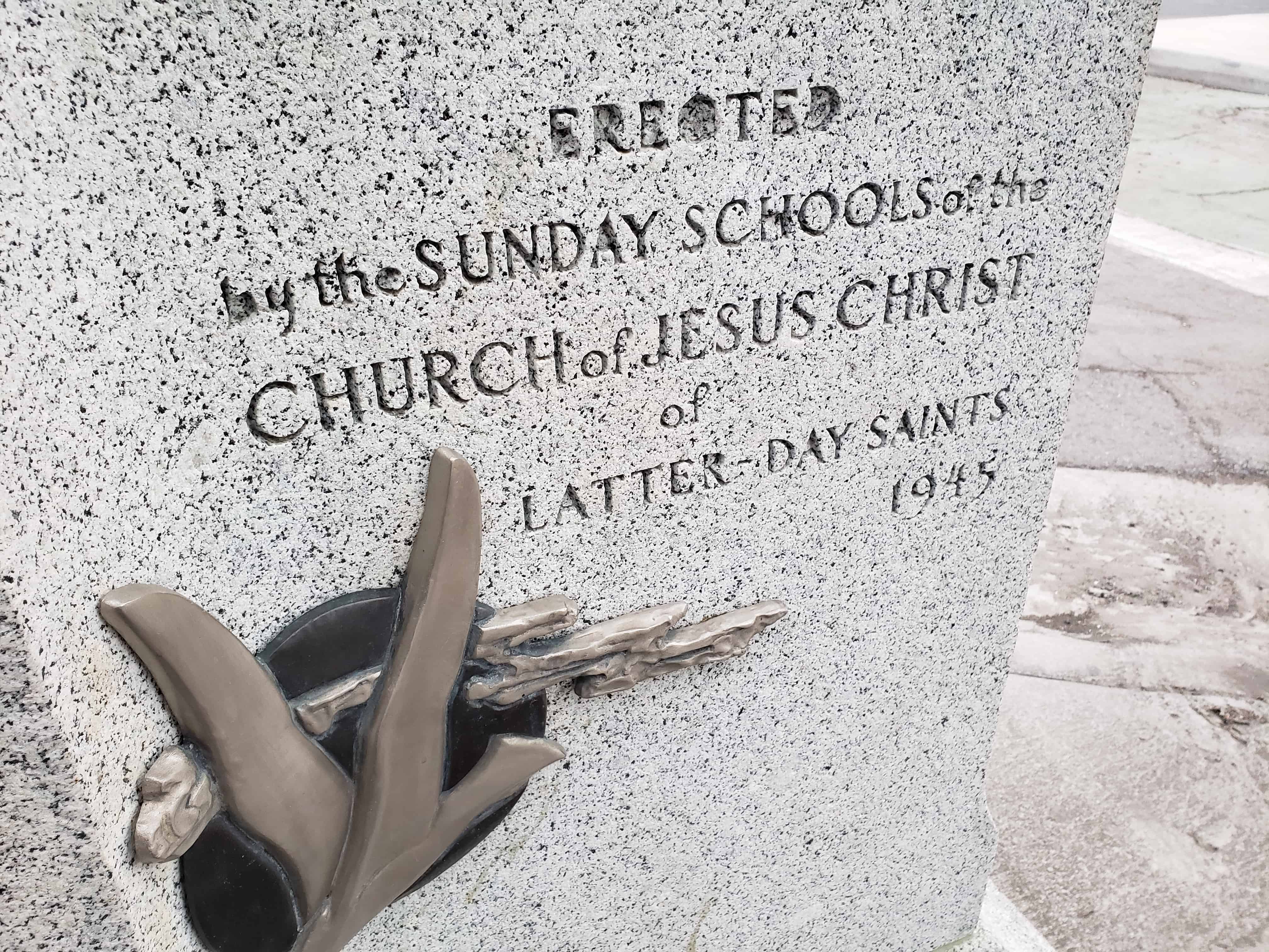
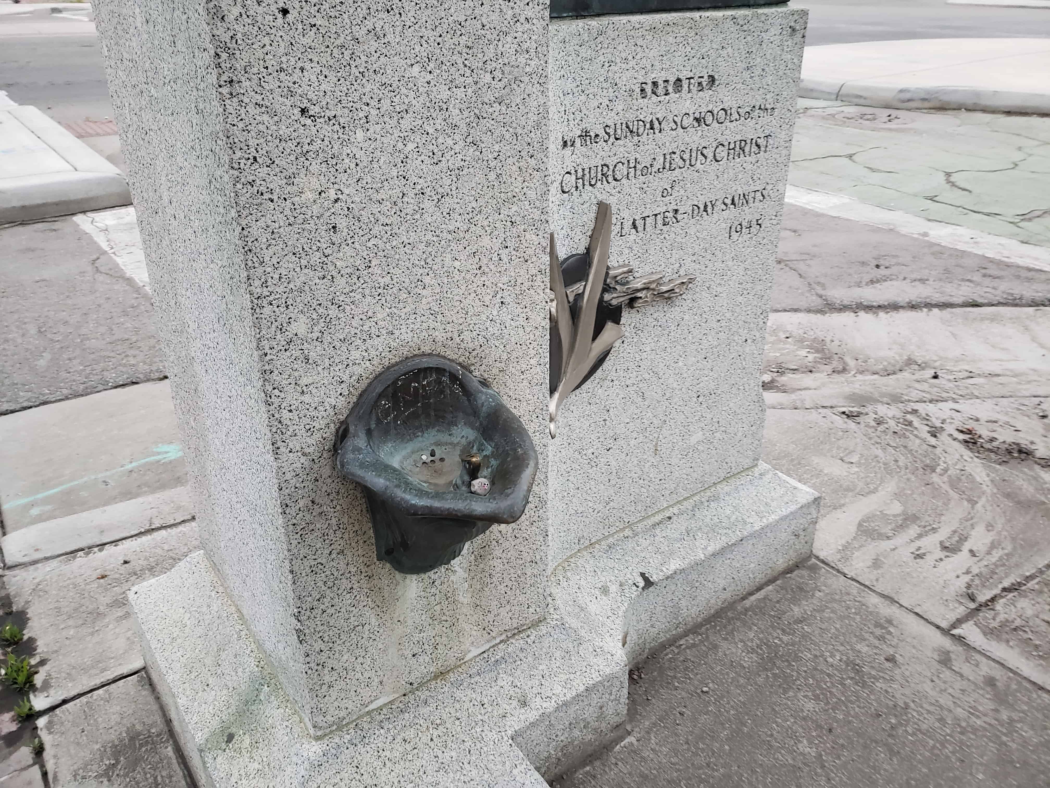
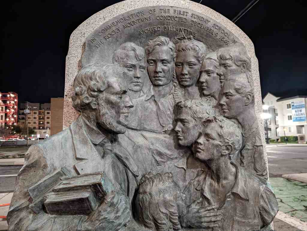
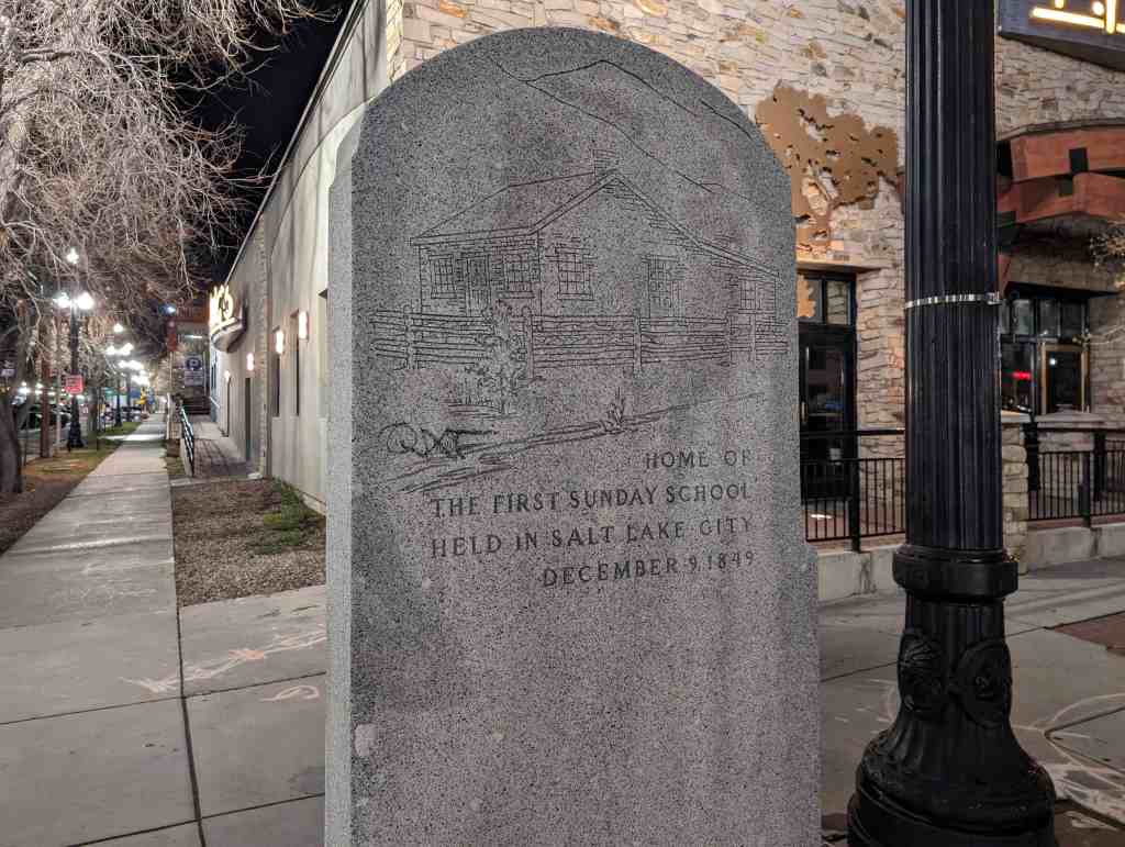
Utah’s First Sunday School
This marker was erected in 1945 to commemorate the first Sunday school that took place near here nearly 100 years earlier.
This historic marker is located out in front of 174 W 300 S in Salt Lake.


25 Sunday Dec 2016
Posted in Uncategorized
Utah’s First Sunday School
This marker was erected in 1945 to commemorate the first Sunday school that took place near here nearly 100 years earlier.
This historic marker is located out in front of 174 W 300 S in Salt Lake.
23 Friday Dec 2016
Posted in Uncategorized
Tags
Downtown SLC, historic, Historic Markers, Salt Lake City, Salt Lake County, SUP, Temple Square, utah

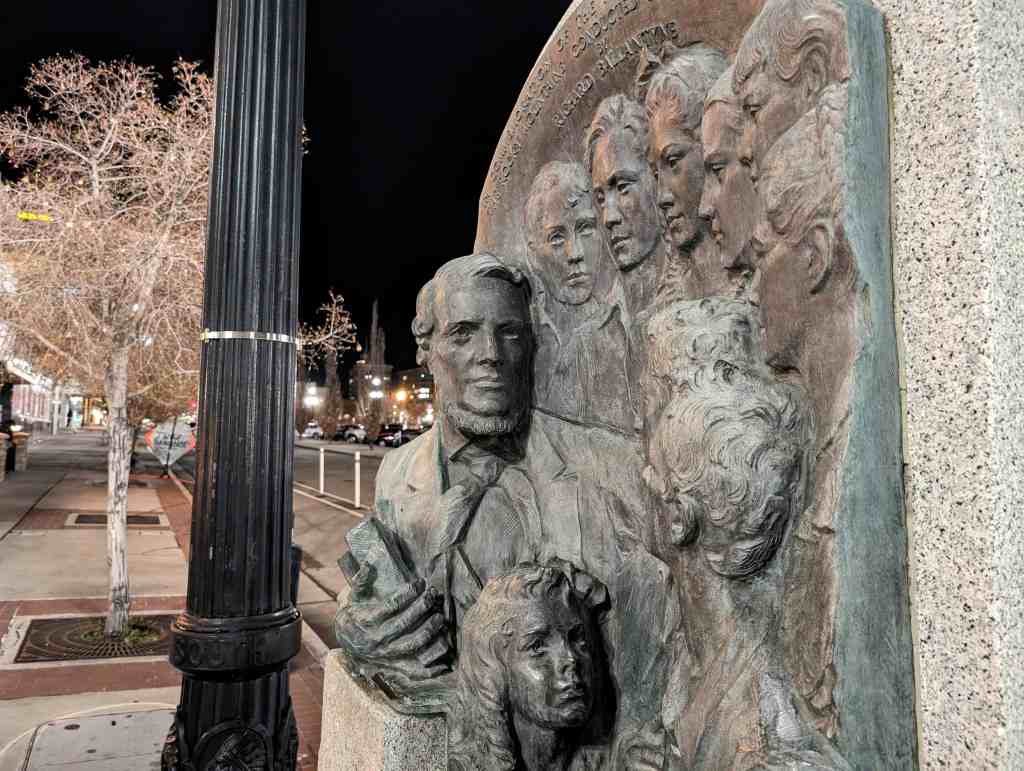
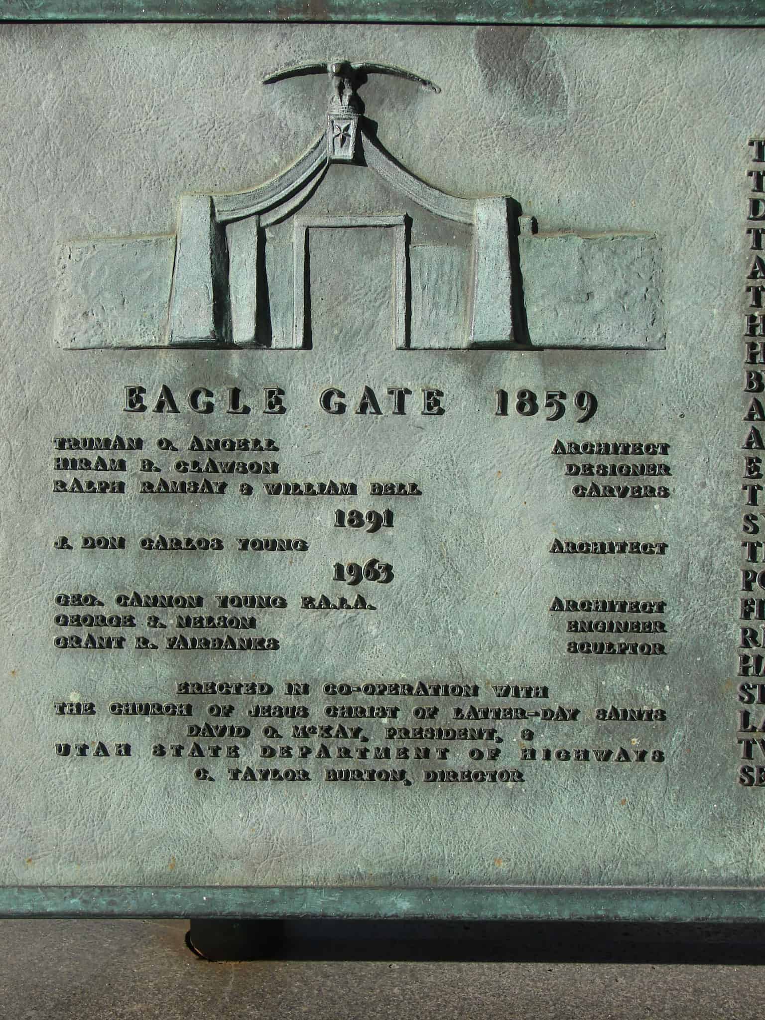
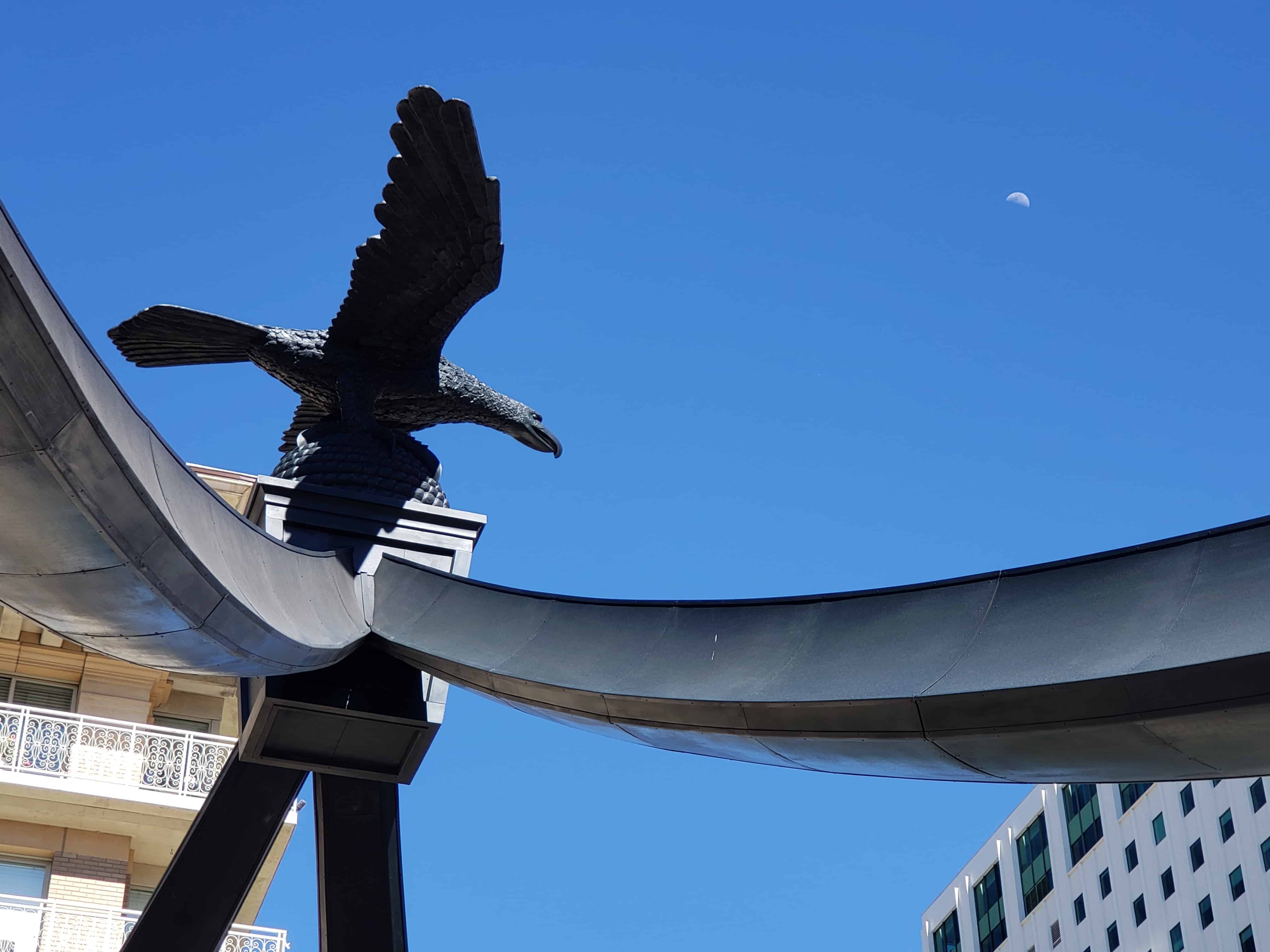
Eagle Gate
“The Eagle Gate was erected in 1859, Hiram B. Clawson, designer; Ralph Ramsay and William Bell, carvers. It formed a part of a cobble stone wall, 8 feet high and 500 rods long, which surrounded the grounds of President Brigham Young and was built by him as a protection against Indians, and to furnish labor to the unemployed. Torn down in 1890 to widen the street and to permit the passage of electric cars. Rebuilt in 1891.”
When the Eagle Gate was reconstructed and dedicated October 5, 1891, a treasure box was sealed in the granite base containing newspapers, photographic views, personal cards and a copper plate engraved by David McKenzie, Containing the paragraph quoted above.
The 16 foot wooden eagle, weighing 500 pounds, the beehive and four-way wooden supports were placed in March 1859, over the original gate way, leading to City Creek Canyon and the private grounds of Brigham Young, Governor of Utah.
At the time of reconstruction the original wooden eagle was sent to Chicago, Electroplated with copper and replaced over the present gate.
See other historic markers in the series on this page for UPTLA/SUP Markers.
Several SUP/UPTLA Markers are located near each other here.
Related:


23 Friday Dec 2016
Posted in Uncategorized
Tags
Downtown SLC, historic, Historic Markers, LDS, Salt Lake City, Salt Lake County, SUP, Temple Square, utah

Location: 51 South and State St. – Social Hall Ave.
This monument marks the site of the Social Hall, the first recreation center in the intermountain west. Built by the Church of Jesus Christ of Latter-day Saints under the direction of Brigham Young. Made of plastered adobe walls with native wood floors and roof. Auditorium 40 by 60 feet, seating 350 persons – stage 20 by 40 feet – dressing rooms and banquet hall in basement. Dedicated January 1, 1853.
Here the Deseret Dramatic Association conducted many home talent theatricals, musicales and other festivities. Sessions of the Legislature, official meetings, receptions, banquets, and other social functions were held here. It was used as theatre, library and gymnasium by the Mutual Improvement Associations.
In 1922 the building was razed.
This is UPTLA Marker #20, see other historic markers in the series on this page for UPTLA/SUP Markers.
Salt Lake City Tour #8 is also here. See also, Social Hall Museum.
Related Posts:

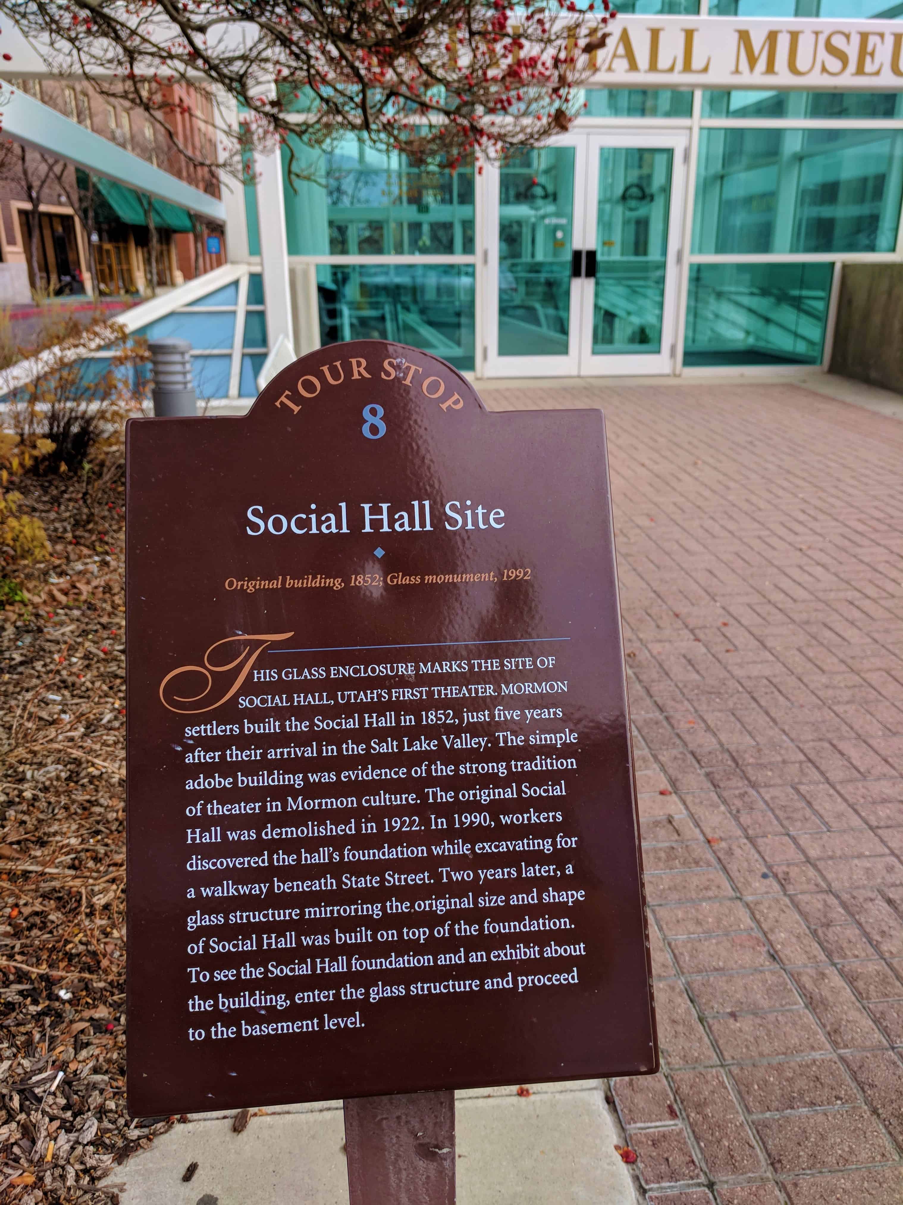
Social Hall Site
Original building, 1852; Glass monument, 1992
This glass enclosure marks the site of Social Hall, Utah’s first Theater. Mormon settlers built the Social Hall in 1852, just five years after their arrival in the Salt Lake Valley. The simple adobe building was evidence of the strong tradition of theater in Mormon culture. The original Social Hall was demolished in 1922. In 1990, workers discovered the hall’s foundation while excavating for a walkway beneath State Street. Two years later, a glass structure mirroring the original size and shape of Social Hall was built on top of the foundation. To see the Social Hall foundation and an exhibit about the building, enter the glass structure and proceed to the basement level.
(Tour Stop 8)


The above photos are from my 2017 visit, I stopped by in 2022 to get updated photos and they have moved the monument down into the Social Hall Museum, same location, lower elevation. Below are the updated photos:


23 Friday Dec 2016
Posted in Uncategorized

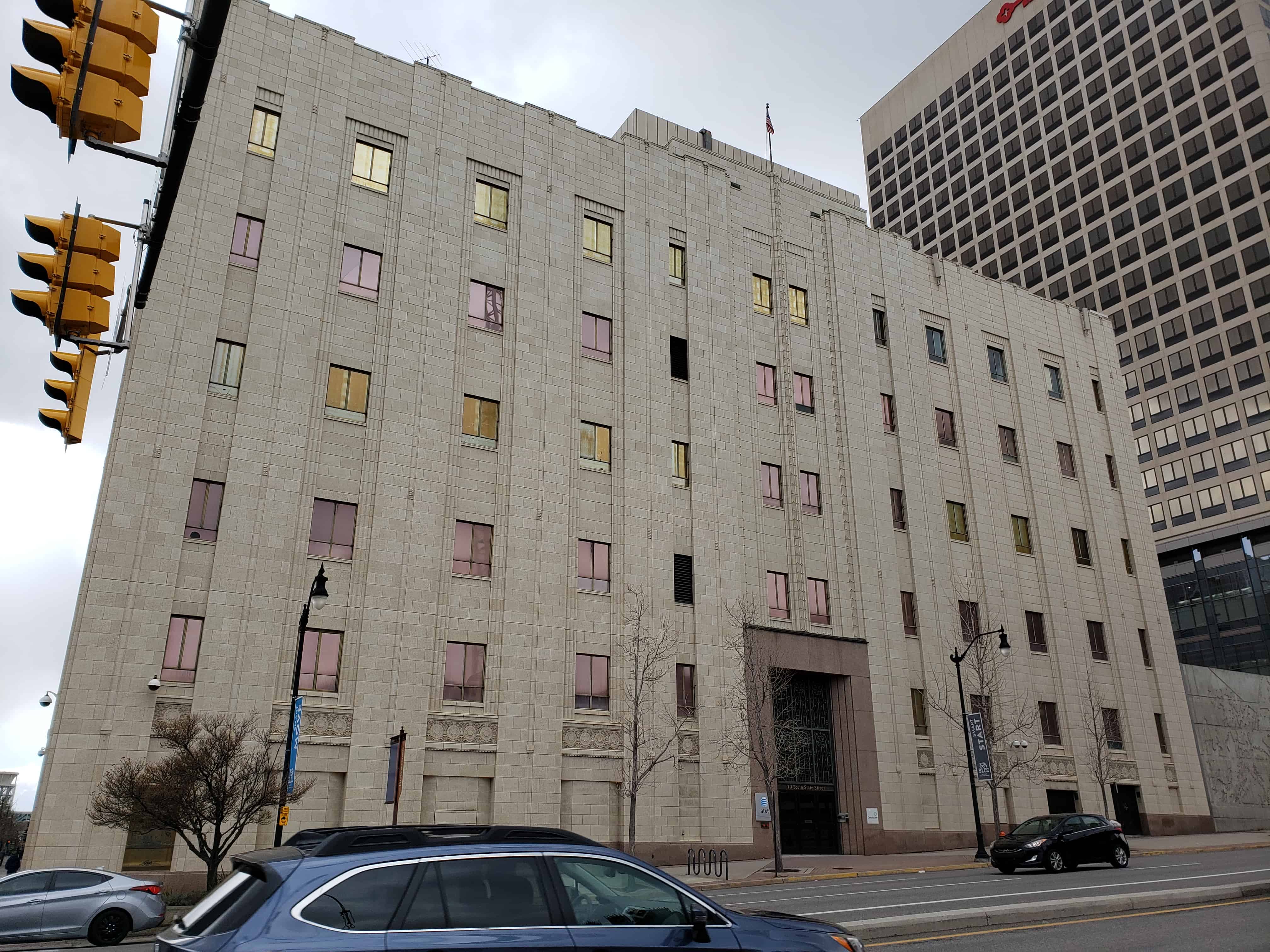
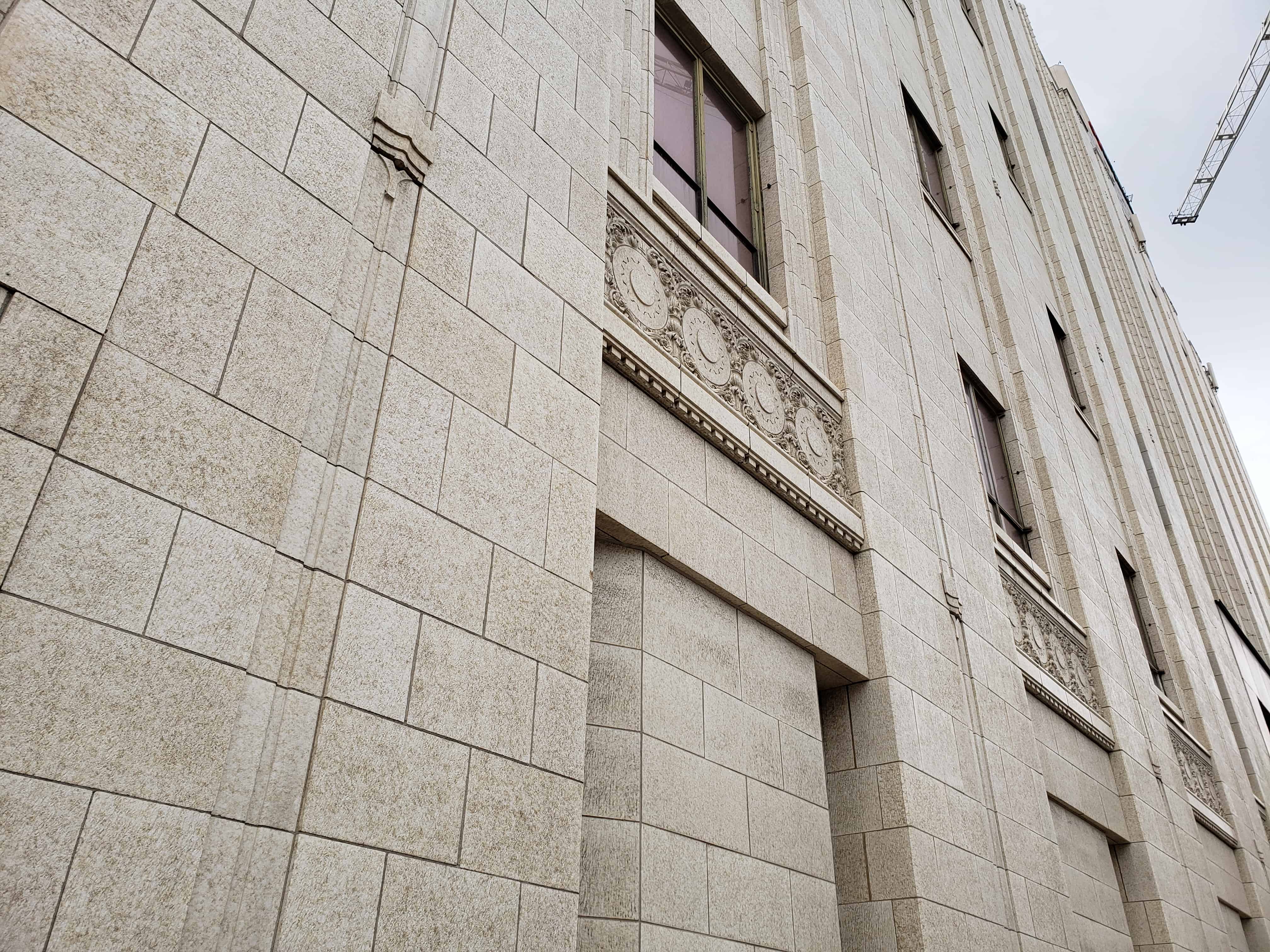
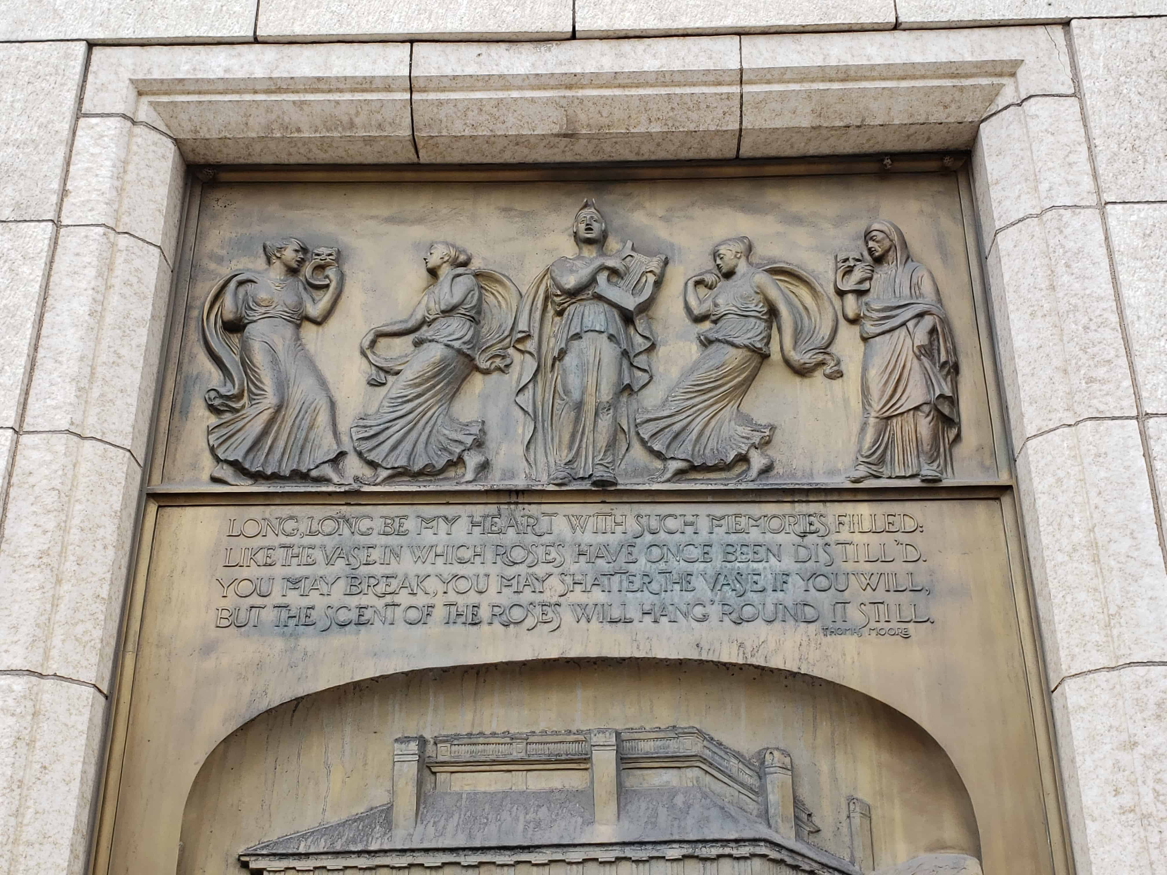
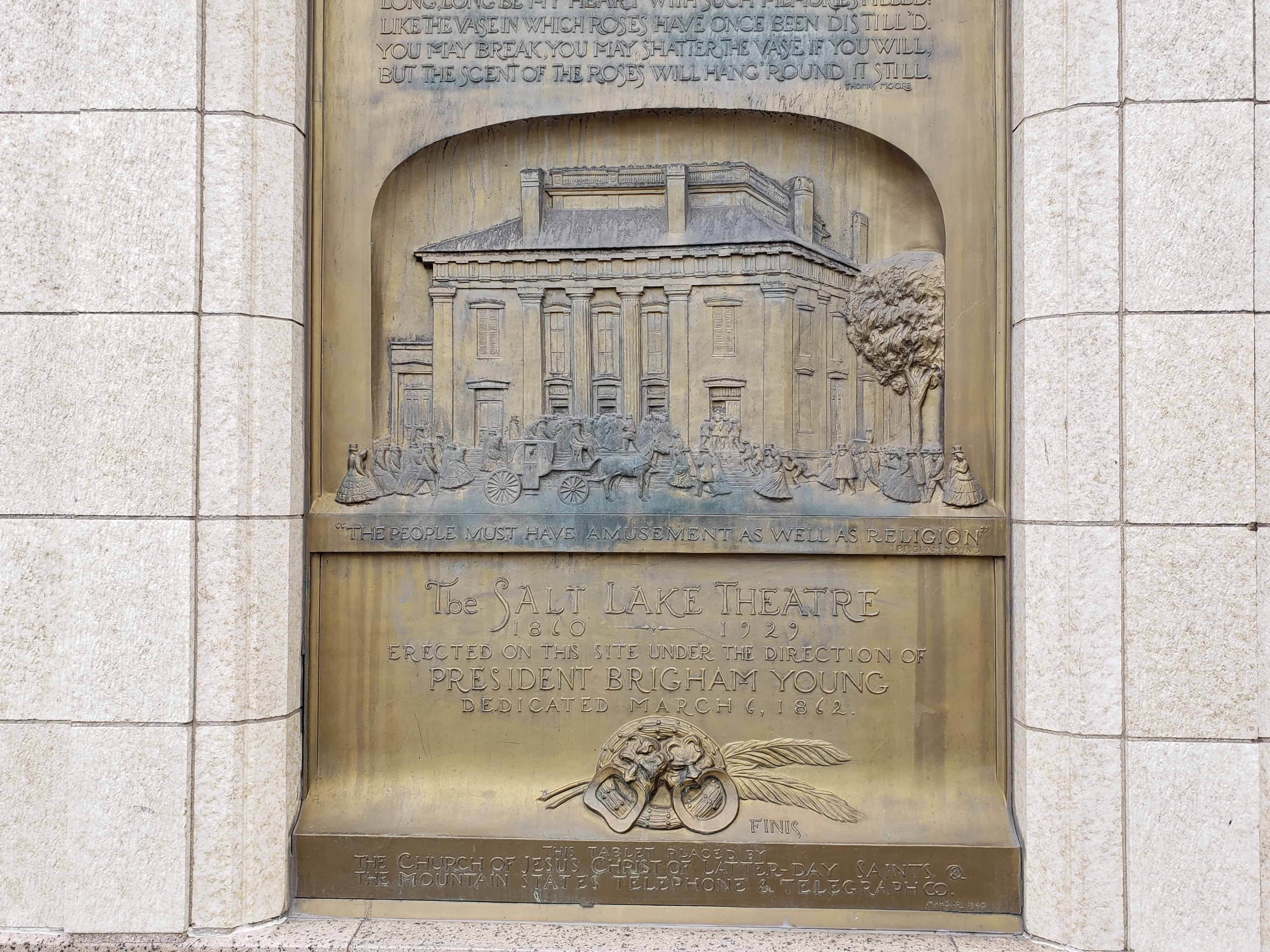
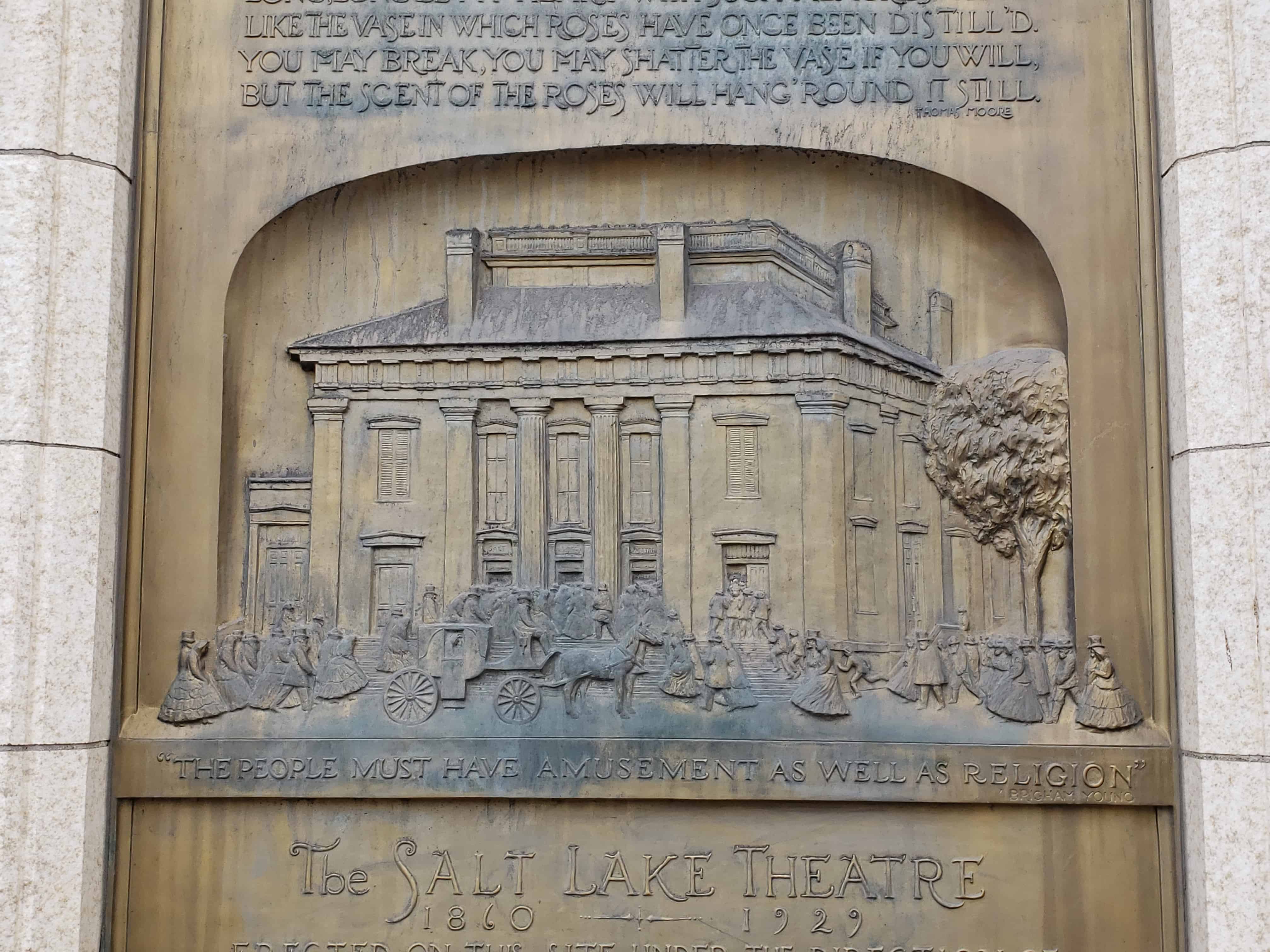
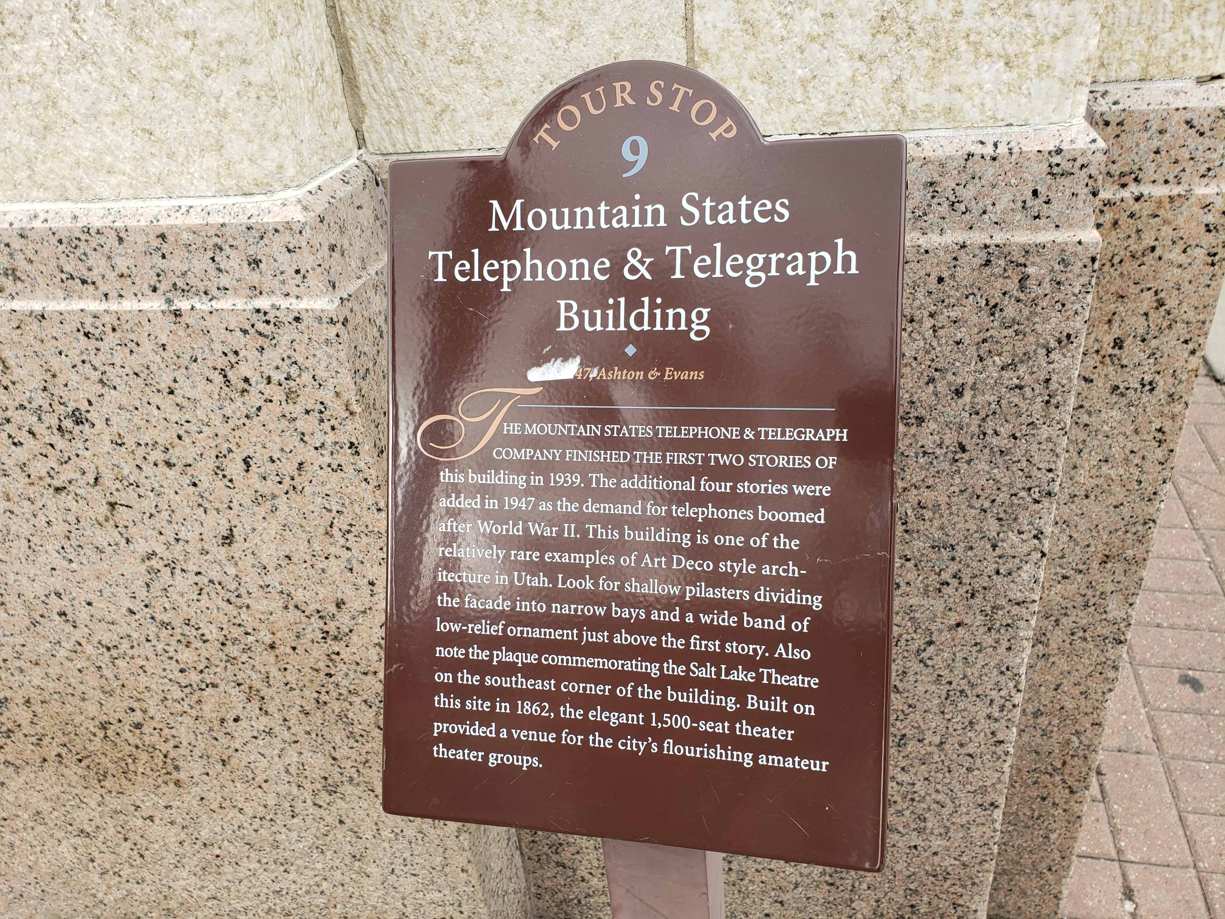
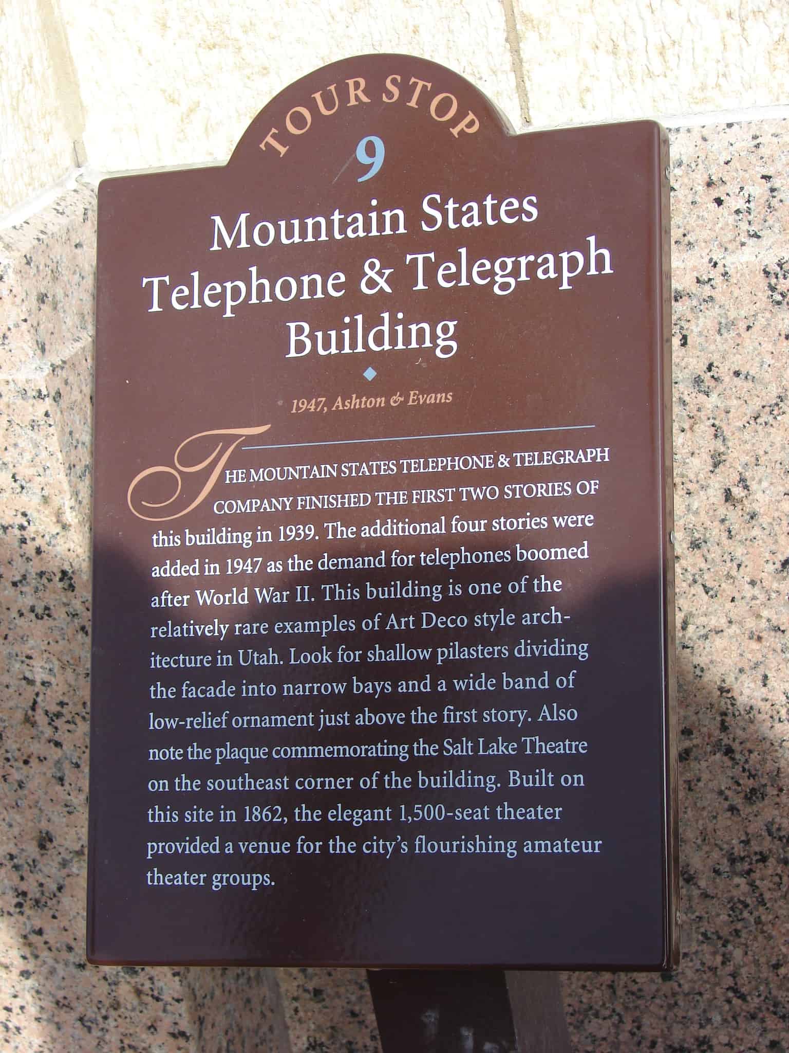
Mountain States Telephone & Telegraph Building
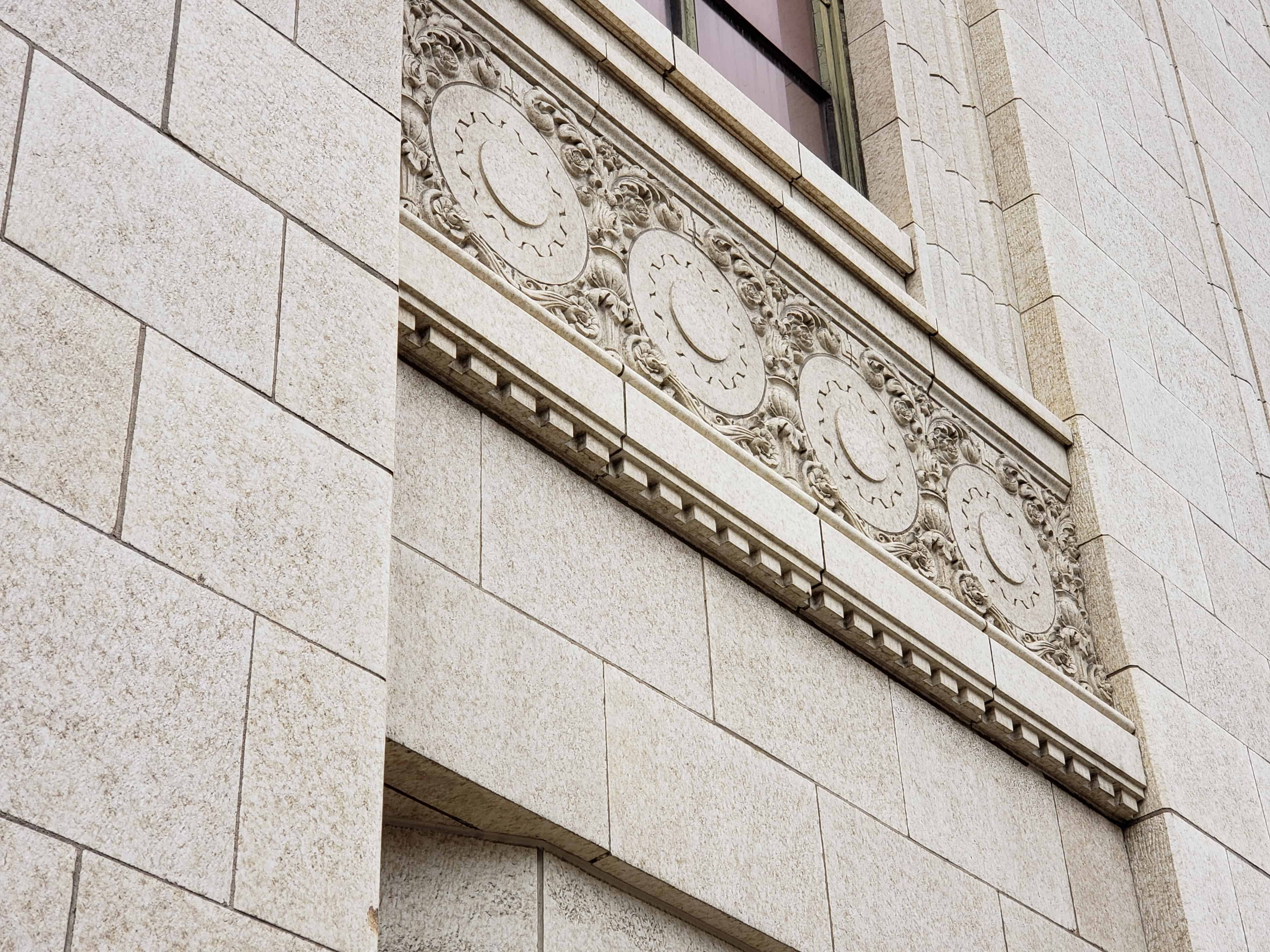
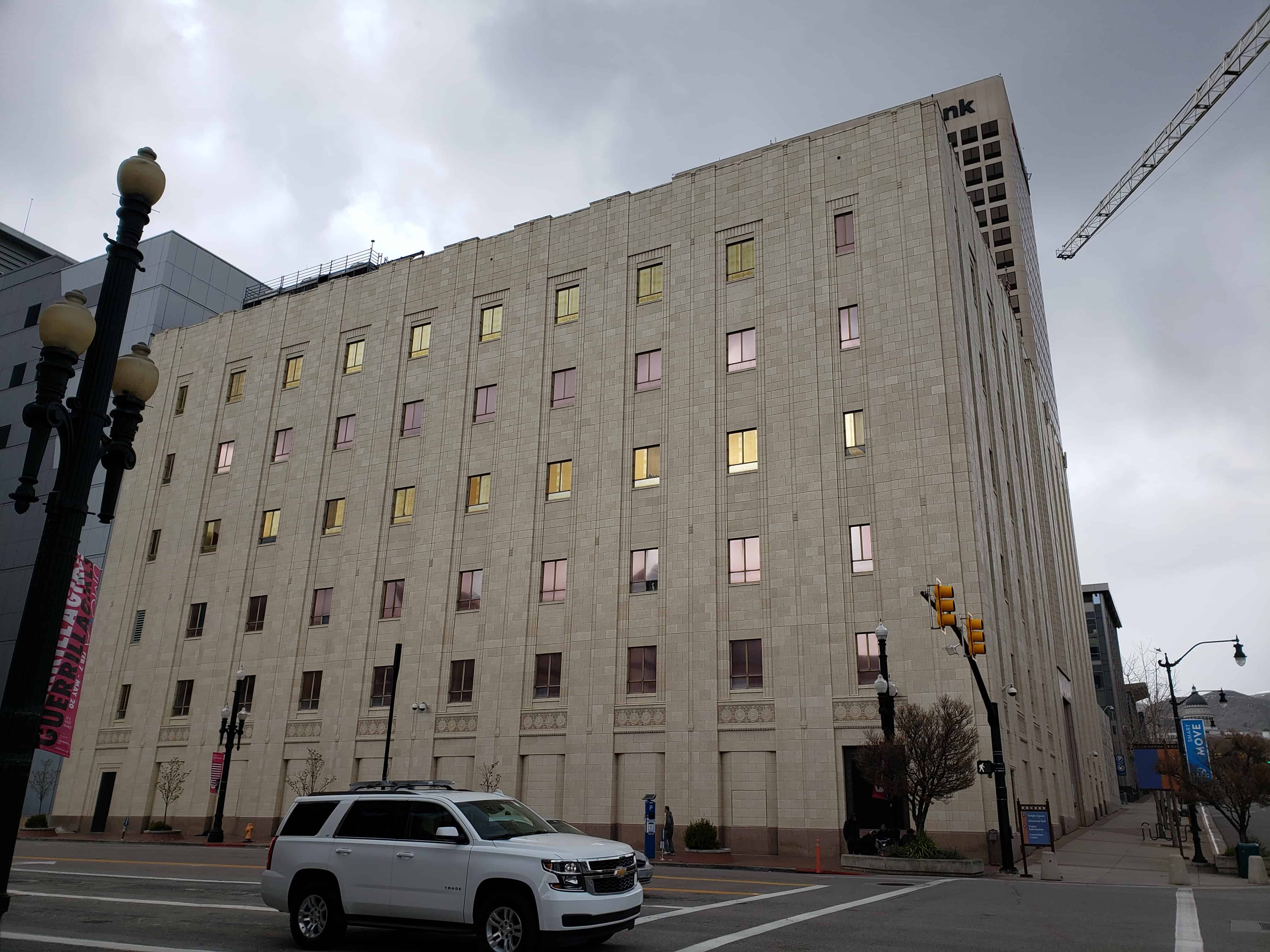
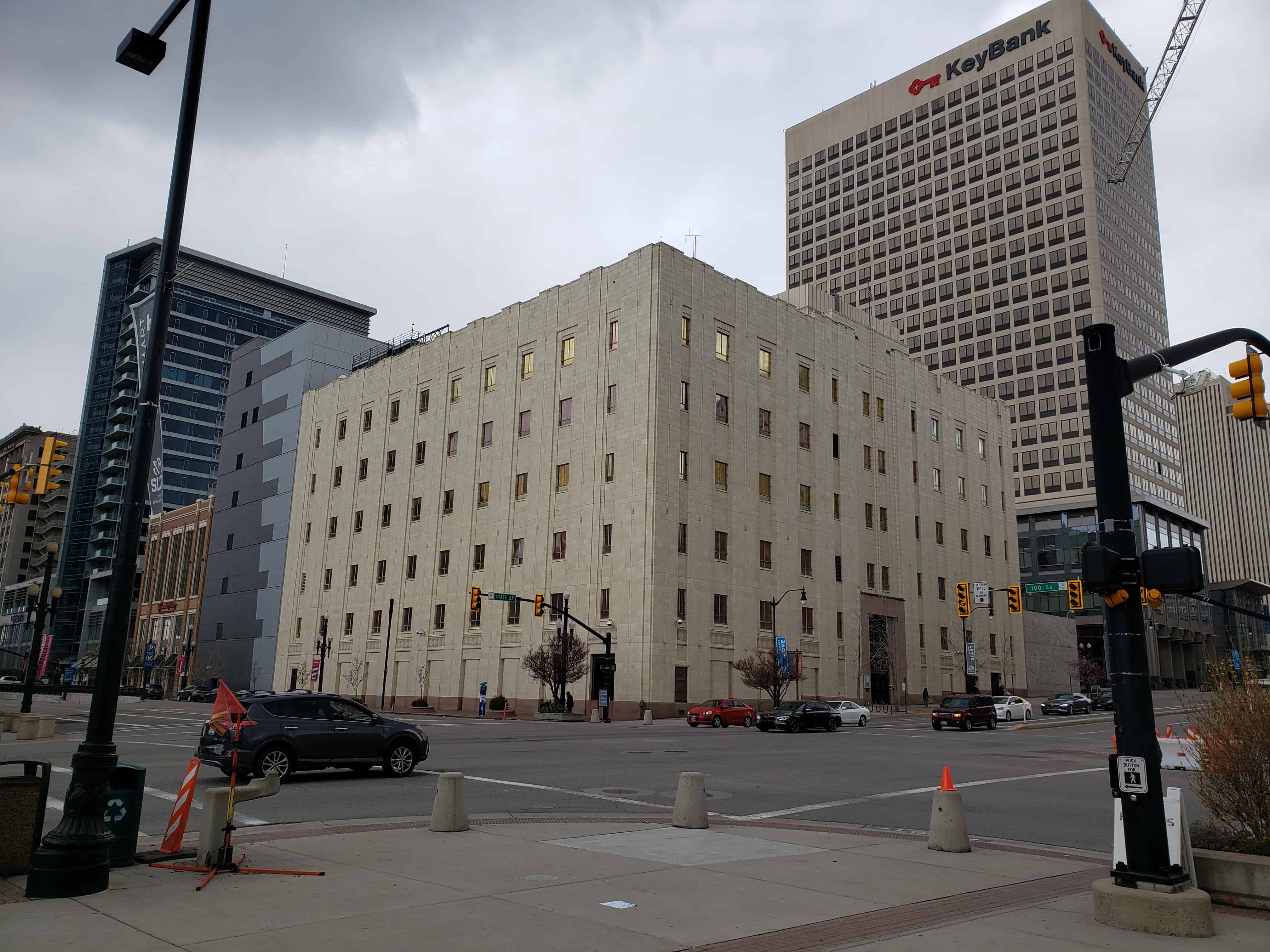
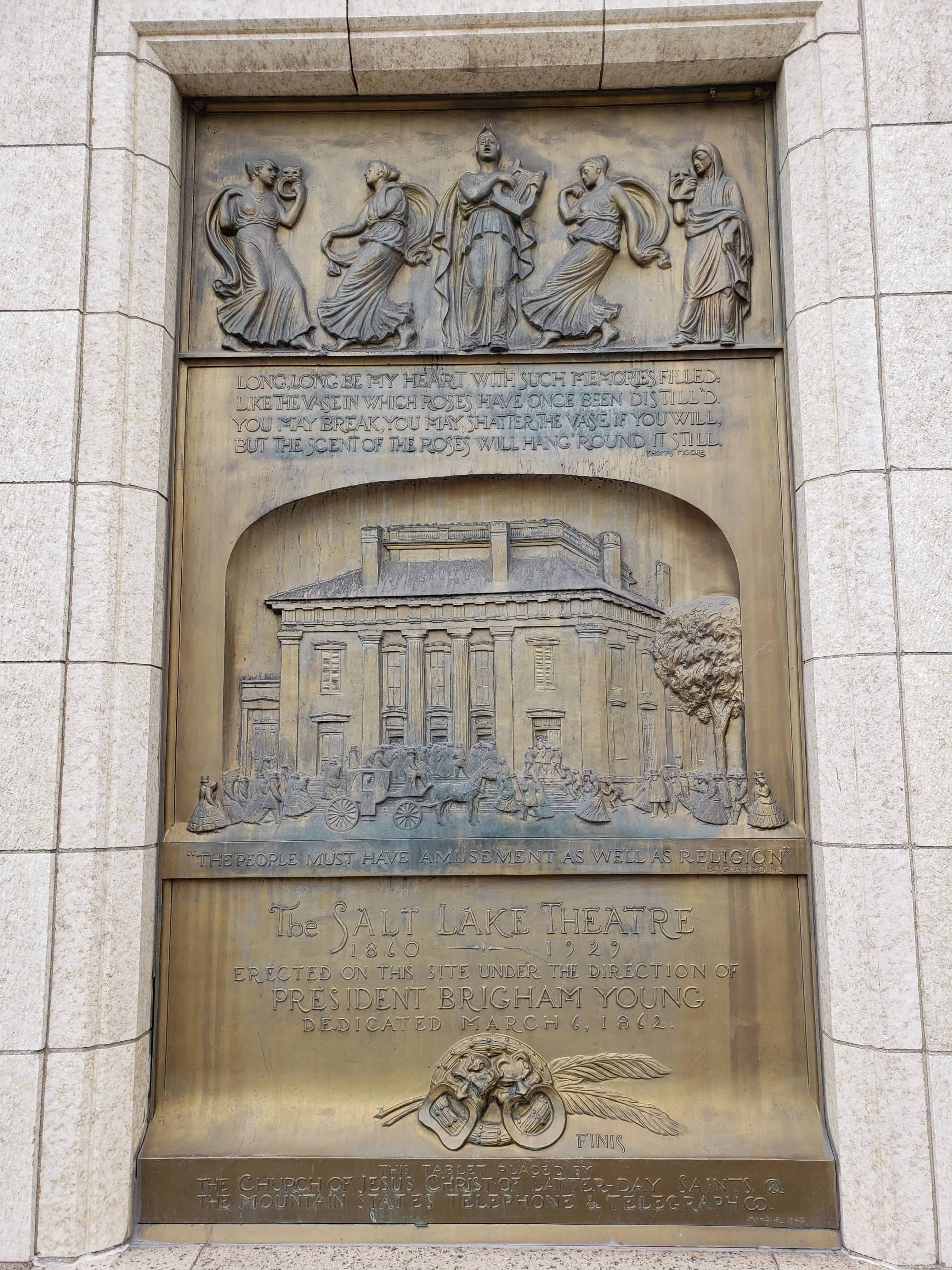
The Mountain States Telephone & Telegraph Company finished the first two stories of this building in 1939. The additional four stories were added in 1947 as the demand for telephones boomed after World War II. This building is one of the relatively rare examples of Art Deco style architecture in Utah. Look for shallow pilasters dividing the facade into narrow bays and a wide band of low-relief ornament just above the first story. Also note the plaque commemorating the Salt Lake Theatre on the southeast corner of the building. Built on this site in 1862, the elegant 1,500-seat theater provided a venue for the city’s flourishing amateur theater groups.
Related Posts:

23 Friday Dec 2016
Posted in Uncategorized
Tags

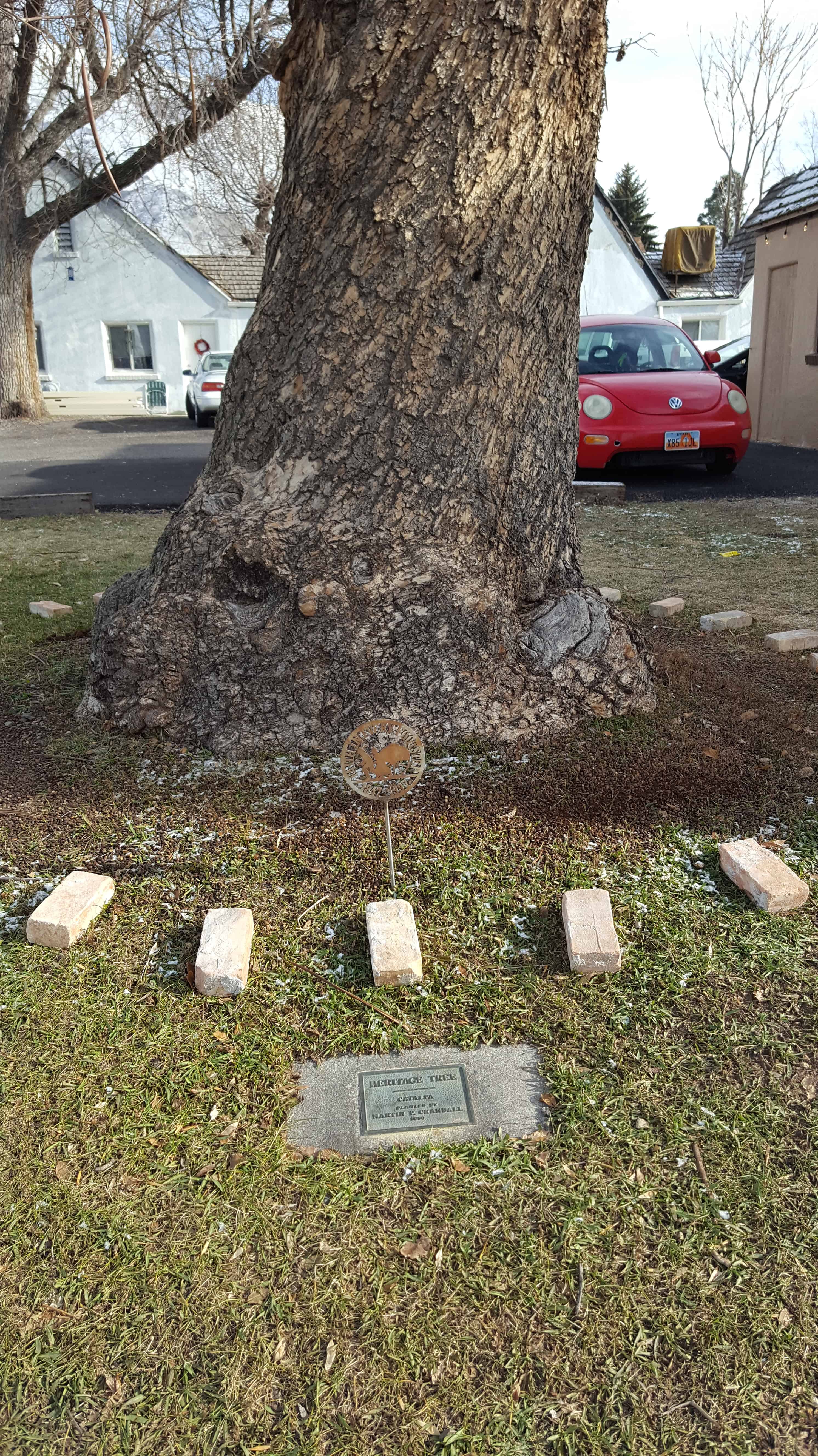
This Catalpa tree in Springville is a Heritage Tree, planted by Martin P. Crandall in 1856.
Located at 388 N Main.
Springville Heritage Trees:


18 Sunday Dec 2016
Posted in Uncategorized
Tags
historic, Liberty Park, NRHP, Parks, Salt Lake, Salt Lake City, Salt Lake County, utah


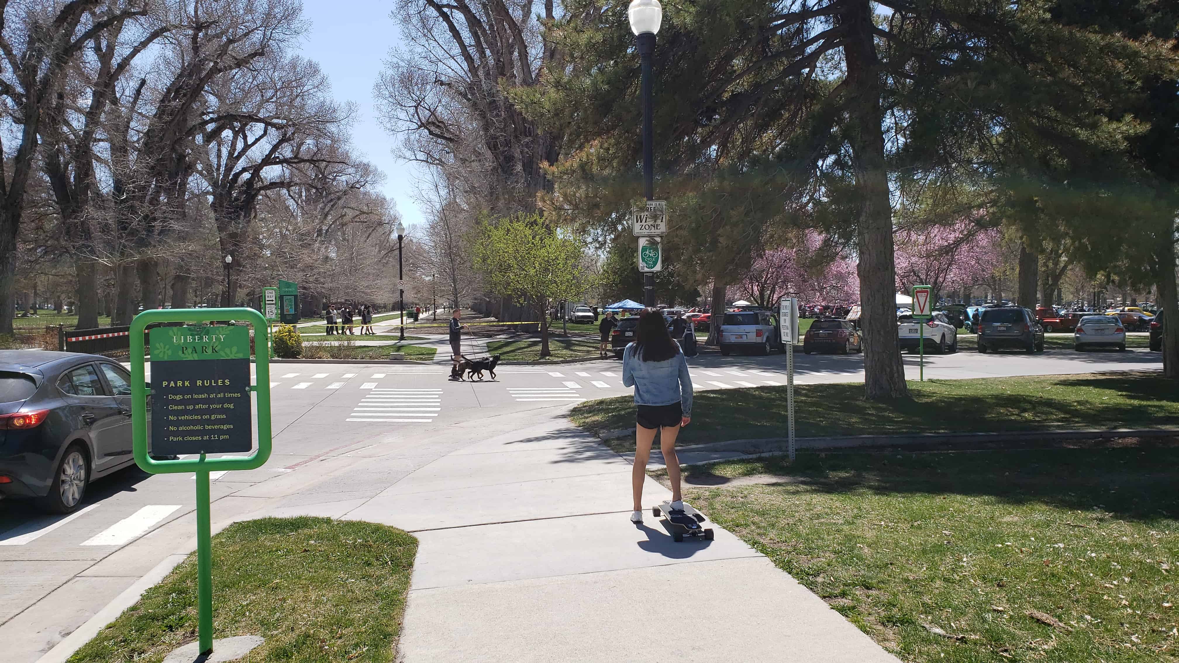
The entire 110 acres of the park was listed on the National Register of Historic Places in 1980 as Liberty Park.
It was established in 1881 upon purchase from the estate of Brigham Young. It is significant as “Utah’s best example of the ‘central park'”, following example of New York City’s Central Park in the general reform movement that represented.
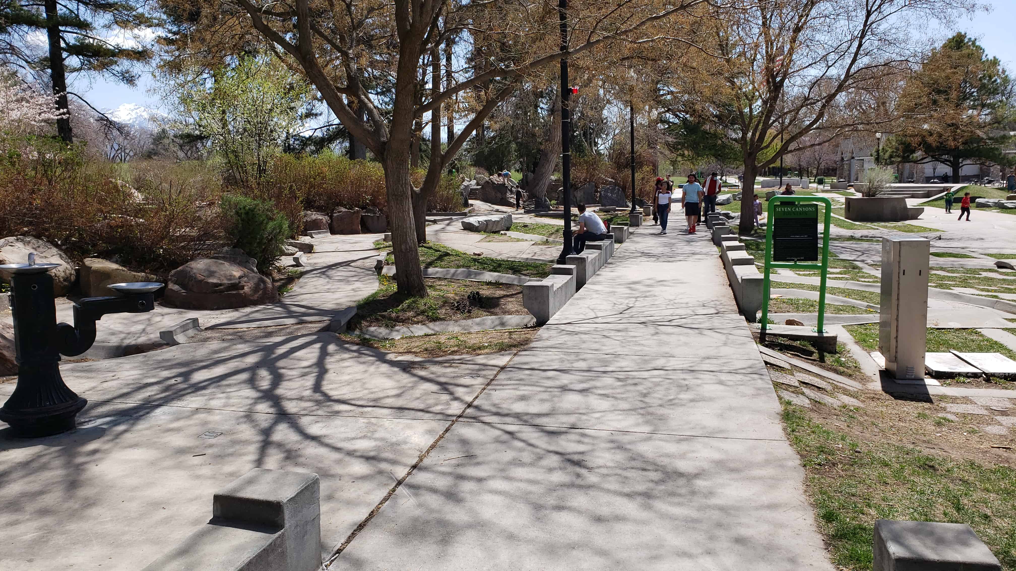
Several historic buildings and markers are located throughout the park.

Liberty Park Posts:


Liberty Park is significant as one of the earliest and largest urban parks in Utah. Originally purchased by Salt Lake City in 1881 from the estate of Brigham Young, it is Utah’s best example of the “central park.” It documents the spirit of reform of the second half of the nineteenth century, when parks were seen as important factors in civilizing America’s increasingly industrialized cities and improving the moral character of their inhabitants. Many American cities followed the pattern of New York City’s Central Park, which was designed in the late 1850’s. Liberty Park is laid out on the site
of a mill and farm established by Isaac Chase (the Isaac Chase Mill is listed on the National Register).

Liberty Park was established on the site of the Isaac Chase Farm and Mill. Chase had been assigned a plot in the original “Big Field Survey” of 1847, which distributed farm plots to the first settlers of the Salt Lake Valley. Because of the mill and the large trees on the farm, it was locally known as Forest Park, the locust Patch and the Mill Farm. The farm and mill were purchased by Brigham Young in 1860, who traded Chase for property in Centerville in Davis County, which Chase never occupied. Brigham Young reportedly expressed the desire that the property be purchased by the city “for the lowest price” after his death. On April 20, 1881, the city paid the Brigham Young estate $27,500 for the farm.

Local newspapers reported that the “locust patch is the only grove within miles of the city and is located about three blocks from the First Ward street car tracks. ‘This grove is large enough for all the purposes that can ever be required….The farm contains as much ground as will be needed for a park for Salt Lake in the next two generations at least, and there is so much that it will never be necessary to keep the grounds like a lawn, as would be the case were it but a ten acre block. The whole can be made to appear rural and rustic, can be sufficiently developed and still give ample room for picnics, for ponds, for walks, for driving and for all other purposes for which parks are used.”
The dedication of the park was originally scheduled for July 4, 1881. Because of the assassination of President Gar field, the celebration was postponed. Although the city waited until the following summer for the dedication, they did not wait until the Fourth of July but instead had the celebration on June 17, 1882, the anniversary of the Battle of Bunker Hill.

The dedicatory procession formed at the City Hall and included Mayor Jennings, ex-mayor Little (who had presided over the purchase of the property), Wilford Woodruff and numerous other city, state, and Mormon Church officials. Music was provided by Croxall’s Silver Band, the Union Glee Club and the Sixth Infantry Band. The remarks of the speakers reflected the popular importance of the new large park. Mr. Ben Sheeks concluded one of the orations by saying that the park “gives to the poor a feeling of interest in his country, and to the rich a satisfaction which ever follows the act of giving to those who needs. And who will say that the man, woman or child does not need the
opportunity of enjoying a pleasant walk of beholding the beauties of art or nature even as they need bread. Let us ever remember that sometimes “the beautiful is as useful as the useful perhaps more so.”

A greenhouse was buit in 1903, and tennis courts added about 1915. The large entrance piers at Sixth East and Ninth South were added in 1920. The bandstand was built about 1911, and a bandstand shelter added in 1949. A swimming pool was constructed in 1949. An appropriation for a zoo was made in 1914, and the zoo remained open until the establishment of the Hogle Zoo in 1931. Russell Tracy donated his collection of birds to the city in 1938, with
appropriations for its construction matched by Tracy in 1938 and 1939.

A master plan has been proposed by the city, which plans to spend four million dollars during the next ten years improving the facilities and landscaping.


Significant Buildings

The Isaac Chase Mill was built between 1847-1852 by Frederick Kepler and/or Phares Wells, Sr., Architect for the mill was William Weeks. There are conflicting accounts concerning the builder(s) of the mill. The milling parts were brought across the plains in 1847 and the mill was built in various stages. The present building was built in 1852. Adobe for the mill were made in an area that was known as the Church farm. This area is now part of the Forest Dale Golf Club. Several smaller structures housed the mill parts prior to this building. The mill has been noted as the first grist mill and flour mill in Utah. In 1854, Brigham Young married Clarissa Ross Chase, a stepdaughter of Isaac’s. In that same year, Brigham Young and Isaac Chase became partners. By this time, Chase had acquired over 100 acres around the mill
site. Chase was appointed superintendent, in charge of the building of mills throughout the LDS church. In 1860, Chase was given land in Centerville by Brigham Young in exchange for his holdings on the mill and adjacent properties. In 1871, John W. Young was listed as the manager of the mill in the Pacific Coast Directory. In 1881, the land and mill were sold to Salt Lake City for development of a park. During this time, some milling appears to have taken place but the mill eventually became used as a supply shed. By 1896, there were efforts to tear the mill down, but fortunately this was never done. The city began leasing the mill to the Daughters of the Utah Pioneers in 1933 for $1.00 a year. The adobe and wood building began deteriorating and in 1970, restoration work started on the building. The building is now restored and open to the public in the summer months. The building is listed on the National Register of Historic Places.

The Isaac Chase House was built in 1853-1854 after the completion of the mill located to the south of the building. Prior to this, Chase and his family resided in a one-room structure on their lot in the Big Field. The house was built of adobe made in the adobe pits located in the area known then as Church Farm. This area is now incorporated in the area of the Forest Dale Golf Club. Isaac and his family resided there until 1860 when they moved to the family home located on State Street in Salt Lake City. He died there in 1861. The house was located in the property that Brigham Young acquired from Chase in exchange for some land in Centerville. George Ogden Chase, a son of Isaac built a house on the property in Centerville. The house was in possession of the Young Family until 1881 when the city purchased the property. After the city purchased the area that would become Liberty Park, the groundskeeper of the park resided there. The house is now used as a relic hall for the DUP at the present time and is open during the summer months.
15 Thursday Dec 2016
Posted in Uncategorized
Tags
historic, Historic Homes, Manti, museums, NRHP, Sanpete County, utah
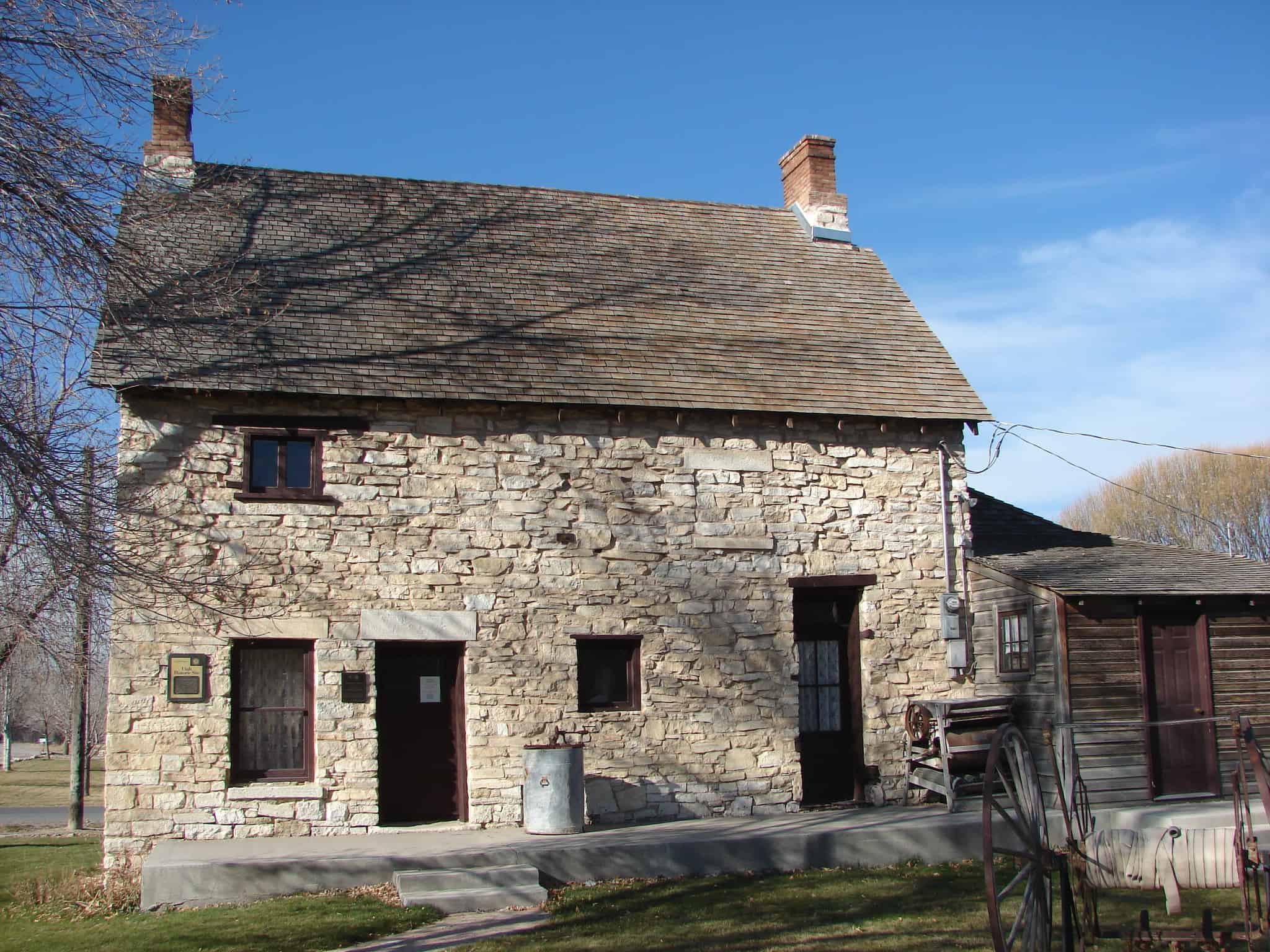
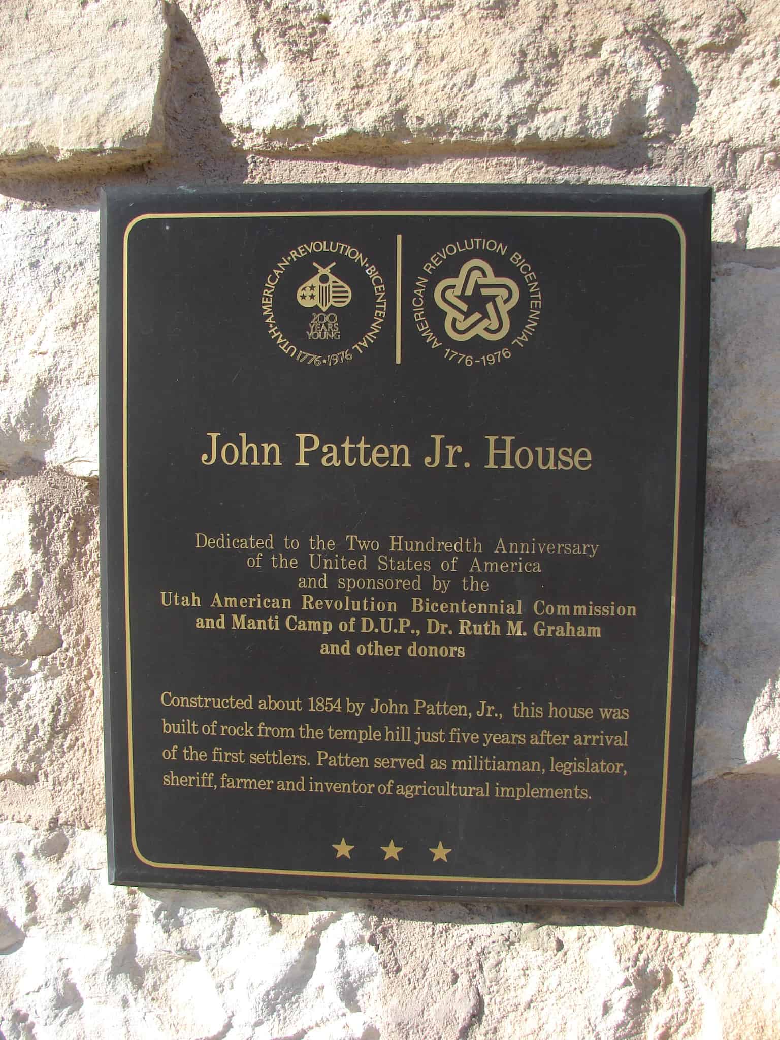
John Patten Jr. House
Dedicated to the Two Hundredth Anniversary
of the United States of America
and sponsored by the
Utah American Revolution Bicentennial Commission
and Manti Camp of D.U.P, Dr. Ruth M. Graham
and other donors
Constructed about 1854 by John Patton, Jr., this house was built of rock from the temple hill just five years after arrival of the first settlers. Patton served as militiaman, legislator, sheriff, farmer and inventor of agricultural implements.
The John Patten House was constructed c.1854 of limestone. John Patten came to Utah in 1850 and settled in Manti. He was active in community affairs serving as a representative to the Utah Territorial Legislature, Sheriff of Sanpete County and a member of the City Council. The vernacular style house is an excellent example of early pioneer stone construction in Utah. The house was acquired May 23, 1976 with the assistance of a grant from the Utah Bicentennial Commission and the help of Dr. Ruth Graham, a descendant of John Patten.

The John Patten House is located at 84 West 300 North in Manti, Utah and was added to the National Historic Register on (#77001315) August 22, 1977.
The two-story limestone home built by John Patten, Jr., c. 1854 is a well-preserved example of early vernacular Mormon architecture in Utah. Patten played a prominent role in the settlement of Manti, established in 1849 as one of the earliest of approximately 400 colonies in the “Mormon Corridor.”
John Patten was born in Fairplay, Green County, Indiana, June 20, 1825. His family was among the earliest converts to the Church of Jesus Christ of Latter-day Saints (Mormon Church). As John grew up, he experienced the many persecutions of the Mormons in Missouri and in 1839 was among those to sign a covenant of protection and removal, authored by Brigham Young in response to an order of extermination by General Clark of Missouri. Patten came to Utah in 18SO and located in Manti, one of Utah’s oldest cities, where he assisted in building the first fort in 1852. He took an active part in the Walker and Black Hawk wars and was one of three witnesses to receive a treaty of peace and deed to Sanpete County from Arapine, Chief of the Ute Indians, May, 1855. Patten was prominent in civic activities, serving as a representative to the Territorial Legislature, Sheriff of the county and member of the City Council. He was married in Manti to Candace Smith who later died, leaving two sons and three daughters. He was married again to Emily, a widow and sister of his first wife. She had three sons and two daughters.
Patten was a farmer by occupation. He built the Patten Reservoir and Patten Ditch, an irrigation system still in use which runs water to farmland five miles north of Manti. Somewhat of an inventor, Patten is credited with constructing the first “go-devil,” a device used to lay off furrows for irrigation flow in farm fields. As a sideline, he also tried to develop a “perpetual motion” machine.
John Patten built his two-story limestone home c. 1854 after living next to the oolitic limestone quarry for a few years. The vernacular style home represents the earliest and most primative form of stone masonry construction in pioneer Utah. The walls of the home were laid in coursed rubble using crude mud mortar, most of which has washed away. Local residents call this mode of construction “dry wall.” The two-overtwo plan with dirt floor cellar also documents a typical early Mormon pioneer plan type. Although some alterations and small additions of brick and wood have been made, the John Patten Home is basically well-preserved. The home was lived in continuously until 1975 when it became a museum for the Daughters of the Utah Pioneers.
04 Sunday Dec 2016
Posted in Uncategorized

Authentic Water Delivery Gate (headgate)
This monument commemorates the coming of water to Imperial Valley and the effort of the pioneers to turn the desert into a productive agricultural area.

03 Saturday Dec 2016
Posted in Uncategorized

The Longest Wooden Suspension Bridge in Utah, in Dewey. The classic, historic bridge was burned in 2008 and replaced.

Built in 1916 – Restored in 2000
The Dewey Bridge, constructed in 1916, is on the National Register of Historic Places. In its prime it was designed to support the weight of 6 horses, 3 wagons and 9000 pounds of freight. It is significant for its outstanding Engineering Accomplishment and for its Historic role as a vital transportation and commercial link connecting Southeastern Utah with Colorado and other points east. In the early decades of the twentieth century, Moab and other Southeastern Utah towns were dependent on communities in Western Colorado for everyday supplies, and markets for their agricultural products. This Bridge, which spans the formidable natural barrier of the Colorado River, was the first to provide a direct connection. Dewey Bridge is Utah’s longest suspension bridge, and at the time of its construction, was the second longest suspension bridge west of the Mississippi. It is also the State’s longest clear span bridge.


03 Saturday Dec 2016
Posted in Uncategorized

John & Harriet Farrer Home
Built in 1904, this single story brick structure is one of the best preserved examples of the cross-wing plan in Sandy. It retains a majority of its original Queen Anne and Victorian eclectic detailing and is expressive of the local craftsmanship and use of native materials. The main entry to the house has been created with an angled vestibule placed at the inside corner of the intersecting wings. the gables at the projecting and intersecting wing are triangulated by a full cornice return and were originally detailed with a variety of patterned shingles.
This building was constructed by it’s owner, John W. Farrer, and may be among the best work of this local builder. John and Harriet Worthington Farrer sold this home in 1909 to Nephi Anderson, a local farmer, who sold the home to Bertram and Maude Vincent in 1918. Bertram died the following year and his wife continued to live in the home and supported herself and her young family by working in the garment industry.
The above text is from the plaque on the home, placed in 1994. The home is located at 39 East Pioneer Avenue in the historic sandy area of Sandy, Utah

