• About JacobBarlow.com
  • Cemeteries in Utah
  • D.U.P. Markers
  • Doors
  • Exploring Utah Email List
  • Geocaching
  • Historic Marker Map
  • Links
  • Movie/TV Show Filming Locations
  • Oldest in Utah
  • Other Travels
  • Photos Then and Now
  • S.U.P. Markers
  • U.P.T.L.A. Markers
  • Utah Cities and Places.
  • Utah Homes for Sale
  • Utah Treasure Hunt

JacobBarlow.com

~ Exploring with Jacob Barlow

JacobBarlow.com

Tag Archives: historic

Historic Homes in Provo

03 Saturday Dec 2016

Posted by Jacob Barlow in Uncategorized

≈ 11 Comments

Tags

historic, Historic Buildings, Historic Homes, Provo, utah, utah county

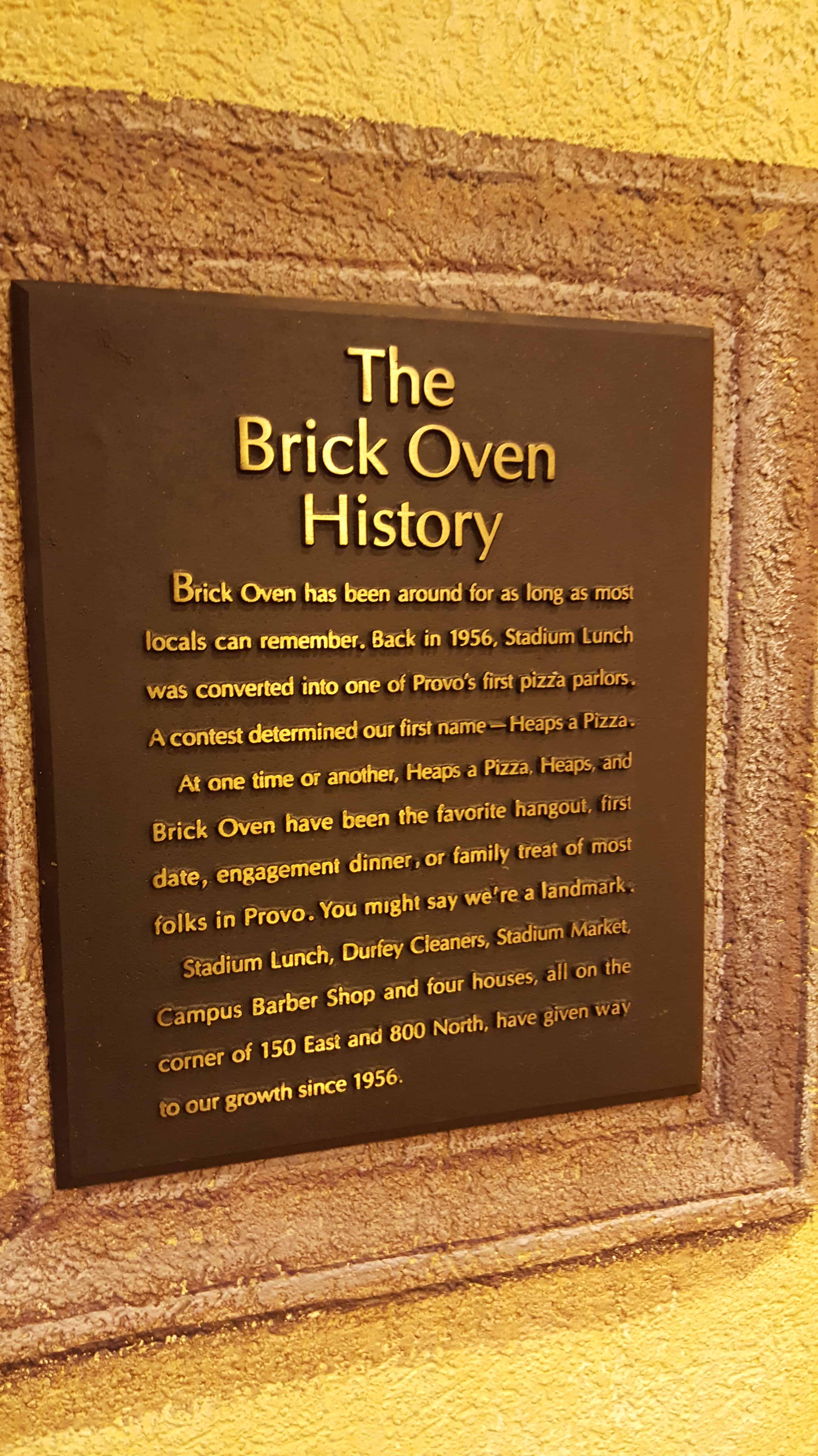
A list of some of the historic homes in Provo.

  • William D. Alexander House
  • Dr. Samuel H. Allen House and Carriage House
  • Angus G. Beebe House
  • Bert and LaPriel Crane House
  • Clark-Taylor Home
  • Charles E. Davies House
  • John and Sarah Lewis Dixon Degray House
  • LeRoy Dixon Home
  • Elizabeth C Kirkwood House
  • Firmage House
  • John F. Meldrum House
  • Fred J. Moore House
  • George M. Brown House
  • George Taylor Jr. House
  • Graham House
  • Harvey H. Cluff House
  • James E. Snyder House
  • George Passey House
  • Jesse W Prothero House
  • John E. Booth House
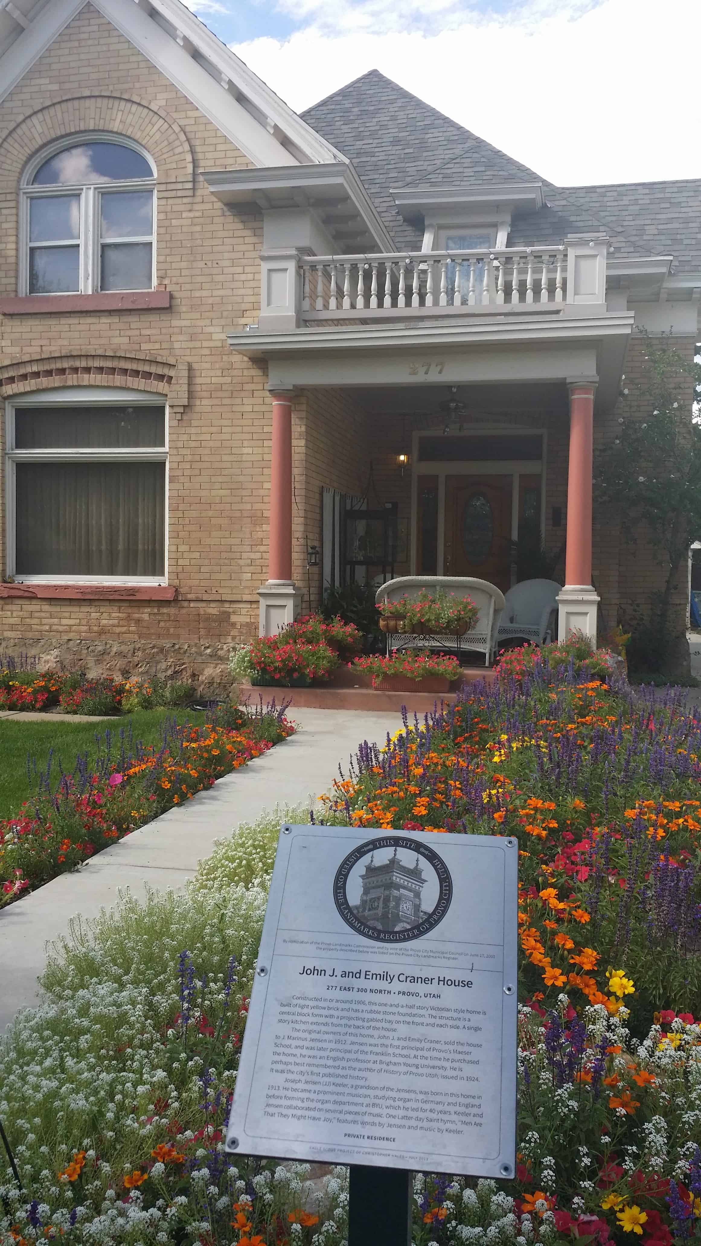
  • John J. and Emily Craner House
  • John R. Twelves House
  • Joseph H. Frisby House
  • Leven-Wolf House
  • Justis Johnson House
  • Lawrence Bean House
  • The Octogon House
  • Pierpont House and Pierpont Mansion
  • Provo’s oldest home
  • C.W. Reid House
  • Silver Row
  • Simon Peter Eggertsen Home
  • Sutton House
  • S.A. Strawhorne House
  • Fred and Mary Taylor House
  • Thomas N. Taylor House
  • Van Wagenen House
  • William D. Roberts House
  • William H. Ray House

Brick Oven

03 Saturday Dec 2016

Posted by Jacob Barlow in Uncategorized

≈ 1 Comment

Tags

historic, Historic Buildings, Provo, utah, utah county

2016-11-30-17-28-51

The Brick Oven History

Brick Oven has been around for as long as most locals can remember.  Back in 1956, Stadium Lunch was converted into one of Provo’s first pizza parlors.  A contest determined the first name – Heaps a Pizza.

At one time or another the landmark of Heaps a Pizza, Heaps, and Brick Oven have been the favorite hangout, first fate, engagement dinner, or family treat of most folks in Provo.

Stadium Lunch, Durfey Cleaners, Stadium Market, Campus Barber Shop and four houses, all on the corner of 150 East and 800 North, have given way to their growth since 1956.

2016-11-30-17-29-10

(from county records)

Heaps A Pizza in 1956 (by Ken Heaps), it became Brick Oven in 1974 and is one of Utah’s oldest restaurants.

  • Oldest Restaurants in Utah

Located at 111 East 800 North in Provo, Utah.

Heritage Park

02 Friday Dec 2016

Posted by Jacob Barlow in Uncategorized

≈ 2 Comments

Tags

DUP, Firsts, historic, Memorials, Mills, Parks, Springville, utah, utah county

2016-11-14-11-42-40

Heritage Park, one of Springville’s Parks.

Heritage Park Flagpole – Dedicated 1976 in honor of Margaret Bird Conover.

First Mills in Utah County

Memorial Bench for George Schmidt (1926-2009)

Friend and mentor to thousands of Eagle Scouts.

Springville Heritage Park

Dedicated to the Two Hundredth Anniversary of the United States of America and sponsored by the Utah American revolution Bicentennial Commission and Springville Federated Women’s Clubs.

An official Bicentennial project of the sponsors, this park is on property acquired by Jacob Houtz in 1851.  In 1915 it became a federal fish hatchery and was abandoned in 1922.  Until deeded to Springville City in 1976 for exclusive park use, the site was neglected and unkempt.

Nelson – Mathis Mercantile

29 Tuesday Nov 2016

Posted by Jacob Barlow in Uncategorized

≈ 1 Comment

Tags

historic, Historic Buildings, St. George, utah, Washington County

2013-04-06-19-53-25

Nelson – Mathis Mercantile

The date the original structure was built on these premises is unknown, but Will and Ernest Nelson owned and operated their mercantile on this site until 1924 when they took in a partner, Gordon Mathis.

It was then that a new facade featuring the prism glass windows was added.  The building was restored  to its original appearance in 1992.  Included in that restoration is what is believed to be the original tin ceiling and fir floor.

Added in 1920, St. George’s only remaining sidewalk elevator can be seen in front of the store.  Recipient of the mayor’s award for historic sites for the year 1992.

2013-04-06-19-55-37
2013-04-06-19-55-49
2013-04-06-19-55-58

This Is The Place Heritage Park

29 Tuesday Nov 2016

Posted by Jacob Barlow in Uncategorized

≈ 3 Comments

Tags

DUP, historic, Historic Buildings, Historic Homes, Historic Markers, LDS, LDS Church, Monuments, Salt Lake City, Salt Lake County, SUP, This Is The Place Heritage Park, utah

The location of the park is where, on July 24, 1847, Brigham Young first saw the Salt Lake Valley that would soon become the Mormon pioneers’ new home. Members of The Church of Jesus Christ of Latter-day Saints believe that Young had a vision shortly after they were exiled from Nauvoo, Illinois. In the vision, he saw the place where the Latter-day Saints would settle and “make the desert blossom like a rose” and where they would build their State of Deseret. As the account goes, Brigham Young was very sick with Rocky Mountain Spotted Fever and was riding in the back of a wagon. After exiting Emigration Canyon and cresting a small hill, he asked to look out of the wagon. Those with him opened the canvas cover and propped him up so he could see the empty desert valley below. He then proclaimed, “It is enough. This is the right place. Drive on.” The words, “this is the place,” were soon heard throughout the wagon train as the Mormon pioneers descended into the valley, their long journey having come to an end. The statement was first attributed to Young by Wilford Woodruff more than thirty years after the pioneer advent.

Over the next several years, tens of thousands of Mormon pioneers emerged from Emigration Canyon and first saw their new home from this same location. A Utah state holiday, Pioneer Day, occurs each year on July 24 to commemorate the Mormon pioneers’ entry into the valley.

See also:

  • Angels Are Near Us
  • Anson Call
  • Eyes Westward
  • First Company of Pioneers into the Valley
  • Green Flake
  • Hark Wales & Oscar Smith
  • Israel and Elizabeth Haven Barlow
  • Jane Elizabeth Manning
  • This Is The Place Obelisk
  • This is the Place State Park (monument)
  • The Riter Cabin
  •  
  • Official Website
  •  

Located at 2601 Sunnyside Avenue in Salt Lake City, Utah

For other State Parks in Utah visit this page. and for other parks in Salt Lake this page.

Mule Canyon Ruin

28 Monday Nov 2016

Posted by Jacob Barlow in Uncategorized

≈ Leave a comment

Tags

historic, Prehistoric, Ruins, San, San Juan County, utah

2016-07-31-12-22-50

Mule Canyon Ruin is an ancestral Puebloan ruin located on Cedar Mesa in Southeastern Utah.  Well preserved Pueblo surface ruins found at this site are over 700 years old. The ruin complex includes above-ground and underground dwellings: a kiva and tower which have been excavated and stabilized as well as a block of twelve rooms. The BLM has constructed a canopy to protect the kiva. Interpretive signing and vault toilets are provided. The site is handicapped accessible and well signed on the highway. The site is open year round and there is no admission fee.

Erastus Fairbanks Snow

27 Sunday Nov 2016

Posted by Jacob Barlow in Uncategorized

≈ 1 Comment

Tags

historic, Historic Markers, St. George, utah, Washington County

2013-04-06-19-49-34

Erastus Fairbanks Snow

Missionary, Founder of St. George,
President of the Cotton Mission

Erastus Snow was born in St. Johnsbury, Vermont in 1818.  He entered the Salt Lake Valley on July 21, 1847, in advance of the first company of Mormon Pioneers.  He was ordained an Apostle at the age of thirty.  As a missionary for The Church of Jesus Christ of Latter-Day Saints, he crossed the Great Plains seven times and published the first foreign translation of the Book of Mormon in Denmark in 1850.  Elder Snow presided over the Cotton Mission from 1861 to 1888 and supervised the construction of the St. George Temple and Tabernacle.

This monument is dedicated to Elder Snow’s leadership and the great sacrifice of the Cotton Mission Pioneers.

May 24, 1997

2013-04-06-19-49-39

Mission San Luis Rey De Francia

20 Sunday Nov 2016

Posted by Jacob Barlow in Uncategorized

≈ 2 Comments

Tags

California, Catholic, historic, Historic Markers, LDS, LDS Church, Oceanside, San Diego County

picture27dec07-071

The historical marker reads as follows:

MISSION SAN LUÍS REY DE FRANCIA

Founded June 12, 1798 by Father Lasuén, then president of the California missions, and administered by Father Peyrí, Mission San Luís Rey is notable for its impressive architecture-a composite of Spanish, Moorish, and Mexican.

The following text was copied from Wikipedia.
Mission San Luis Rey de Francia was founded on June 13, 1798 in what is now the town of Oceanside, California. In 1816, Mission San Antonio de Pala was established twenty miles inland as its asistencia (“sub-mission”). The local Payomkowishum tribe became known as the Luiseño, after the San Luis mission. An early account of the mission was written by one of its Luiseño neophytes, Pablo Tac.

No services were held at the Mission for 46 years. It was not until 1892 when two Mexican priests were given permission to restore the Mission as a monastery; Father Joseph O’Keefe was assigned as an interpreter for the monks. It was he who began to restore the old Mission in 1895. The cuadrángulo (quadrangle) and church were completed in 1905. Today, Mission San Luis Rey de Francia is a working mission. It is cared for by the people who belong to the parish, and is still being restored. There is a museum and visitors center at the Mission, as well as a small cemetery.

picture27dec07-069

picture27dec07-070


Located at 4050 Mission Ave in Oceanside, California.

Also located here:

  • The Mormon Battalion (historic marker)

Related:

  • The Mormon Battalion

Arizona’s Honeymoon Trail

19 Saturday Nov 2016

Posted by Jacob Barlow in Uncategorized

≈ 1 Comment

Tags

Arizona, DUP, historic, LDS, LDS Church, Maricopa County, Mesa

2016-09-05-17-24-06

DUP Marker #532 – Located in Mesa’s Pioneer Park.

Arizona’s Honeymoon Trail

For nearly forty years, couples from Arizona settlements left their homes each fall after harvest and traveled 400 miles to St. George, Utah. Winding slowly through desert and steep canyons, crossing barren plateaus, and passing rivers and pools of undrinkable water, these travelers made their way to be married in the St. George Temple, the only temple completed at that time. The trail followed the old wagon road across the Colorado River at Lee’s Ferry. Couples from Snowflake and Taylor were the first known to make the trip in 1881. Some couples married in civil ceremony before leaving, while others were escorted by chaperones. A few couples, waiting to afford the trip, had children who accompanied them. Frequently couples banded together for the trip. Before leaving on the long, hazardous journey, wagons were loaded with food packed in grub boxes, and water barrels were mounted on the wagon sides. Supplies of hay and grain for the animals were also transported. When needed, settlers along the way furnished food and water from their meager supplies.

Because of the romantic nature of these adventures, reporter Will C. Barnes gave the route its name, The Honeymoon Trail. After the Atlantic Pacific Railroad was completed in 1885, a few couples went by train, and later by auto. When the Mesa Arizona Temple was dedicated in 1927, the journey was no longer necessary. The old trail still is visible in a few places. The route was added to the National Register of Historic Places in 1986. This slender thread that connected the Arizona settlements to the St. George Temple became an enduring testimony to the faith of these settlers, members of The Church of Jesus Christ of Latter-day Saints. A pattern of sacrifice aided the pioneers in settling the Arizona and New Mexico wilderness.

2016-09-05-17-23-54
2016-09-05-17-23-09

Mesa

19 Saturday Nov 2016

Posted by Jacob Barlow in Uncategorized

≈ 1 Comment

Tags

Arizona, DUP, historic, LDS, LDS Church, Maricopa County, Mesa

2016-09-05-17-23-33

DUP Marker #169 – Located in Mesa’s Pioneer Park.

Mesa

Early in 1878 a hardy band of Mormon pioneers arrived on this mesa. With a straight edge and a spirit level they proved the feasibility of using the ancient Montezuma Canal to bring life-giving irrigation water from the Salt River to the desert sands. On February 14th work began on this project. A survey was made and stakes driven, May 16, 1878, to plat the townsite according to the “City of Zion” plan given by Joseph Smith, the founder of the Church of Jesus Christ of Latter-Day-Saints. Elijah Pomeroy was the first Bishop of Mesa and A. F. McDonald the first Mayor. Maricopa County

2016-09-05-17-23-54
2016-09-05-17-23-26


← Older posts
Newer posts →

Follow Jacob

Follow Jacob

Blog Stats

  • 2,033,157 hits

Social and Other Links

BarlowLinks.com

Recent Posts

  • Dixie Sorghum (Molasses) Mill
  • This is the Place State Park
  • Eyes Westward
  • Wellsville Relief Society Meetinghouse
  • Angels Are Near Us

Archives


Loading Comments...